

Weather webcast with Lisa Michaels
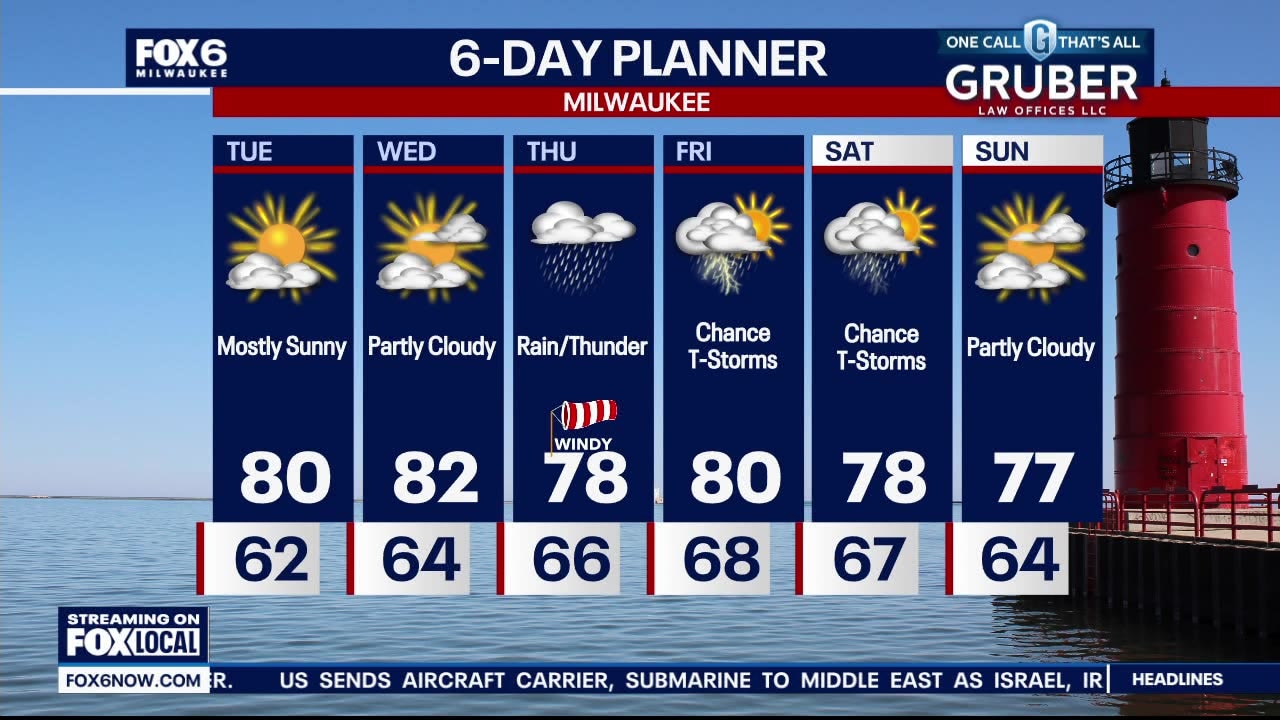
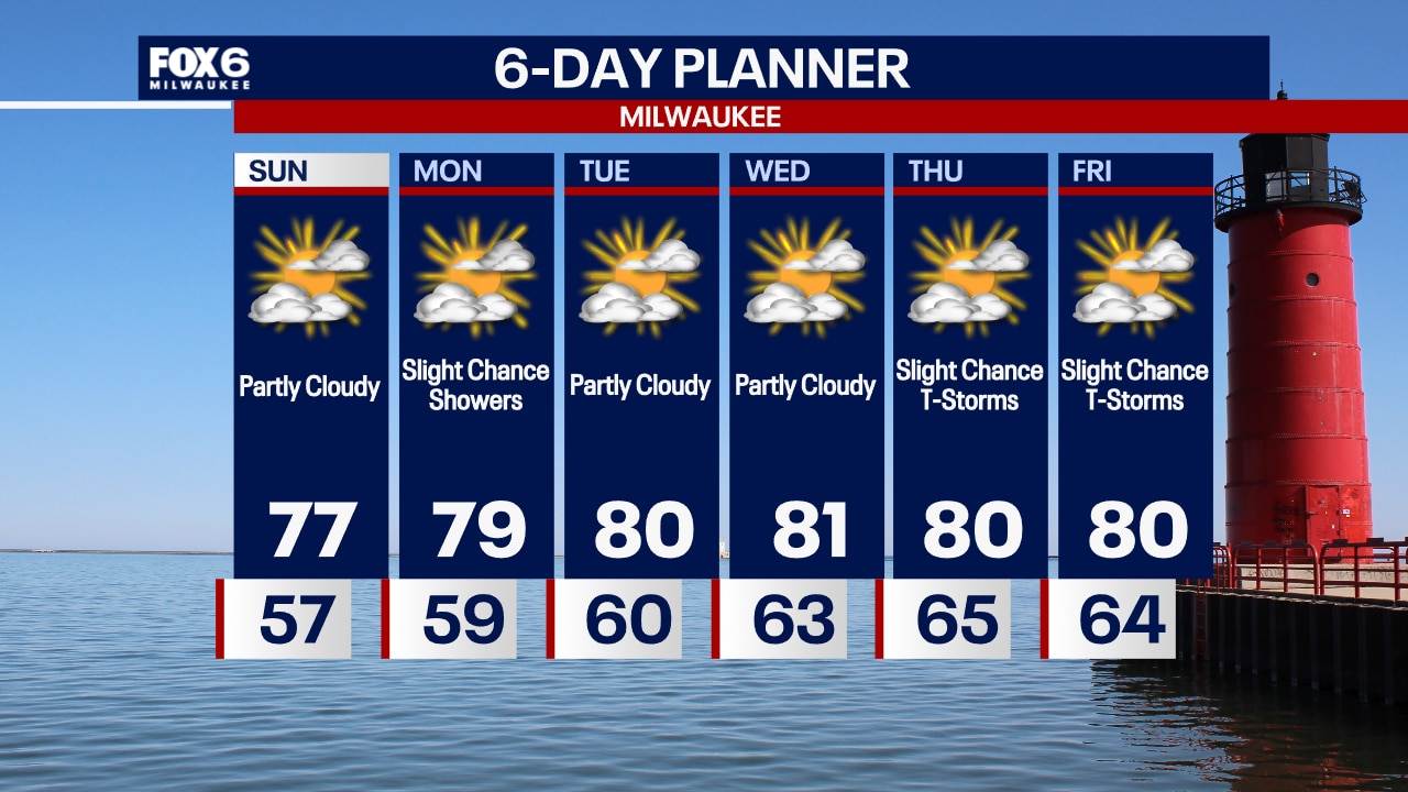
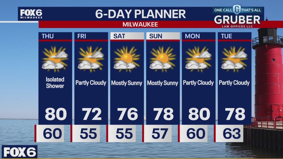
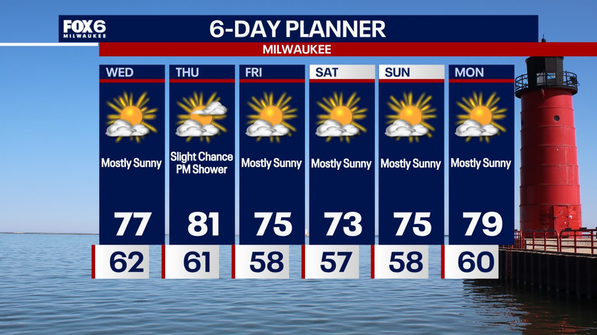
An isolated shower this afternoon/evening. Otherwise, mostly clear with lows in the low 60s. More seasonable temps this week in the low 80s. High pressure keeps us dry for the first half of the week through Wednesday. We are mostly dry today through Wednesday afternoon but then enter a soggy period from Wednesday night through the weekend. We could see 1.5 - 2.0 inches of rain over a few days later this week.
An isolated shower this afternoon/evening. Otherwise, mostly clear with lows in the low 60s. More seasonable temps this week in the low 80s. High pressure keeps us dry for the first half of the week through Wednesday. We are mostly dry today through Wednesday afternoon but then enter a soggy period from Wednesday night through the weekend. We could see 1.5 - 2.0 inches of rain over a few days later this week.
Weather webcast with Rob Haswell
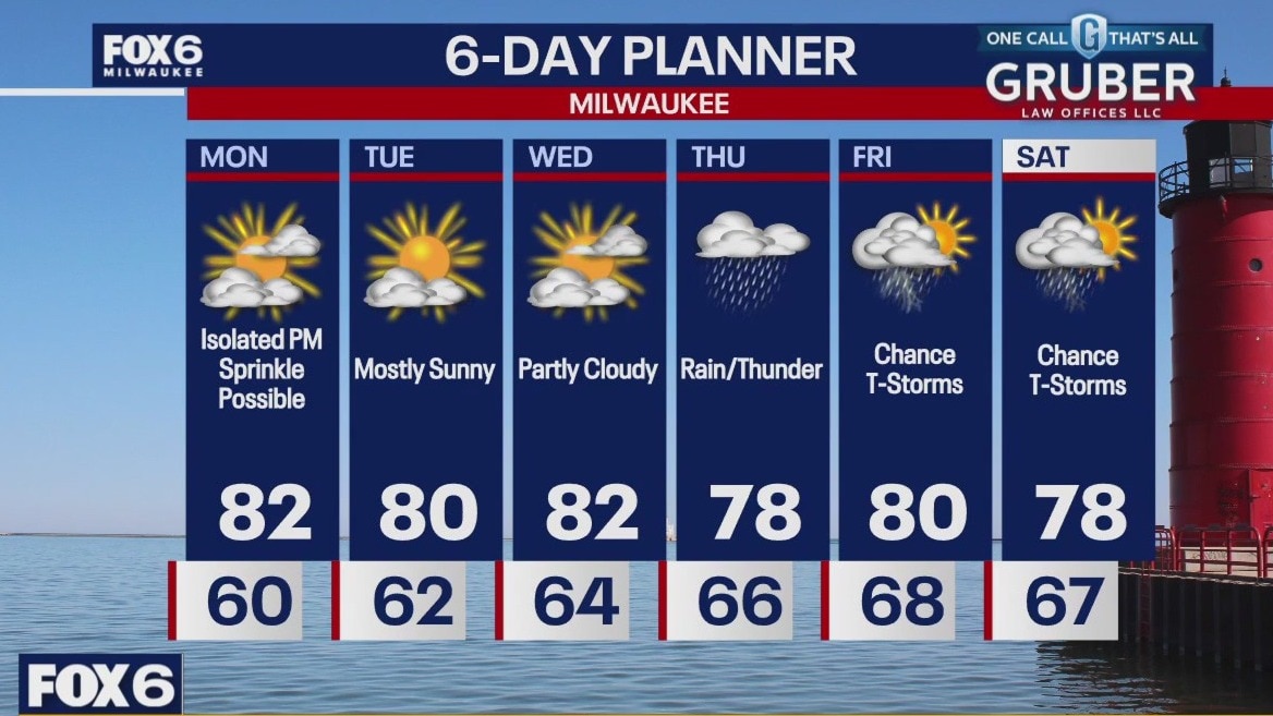
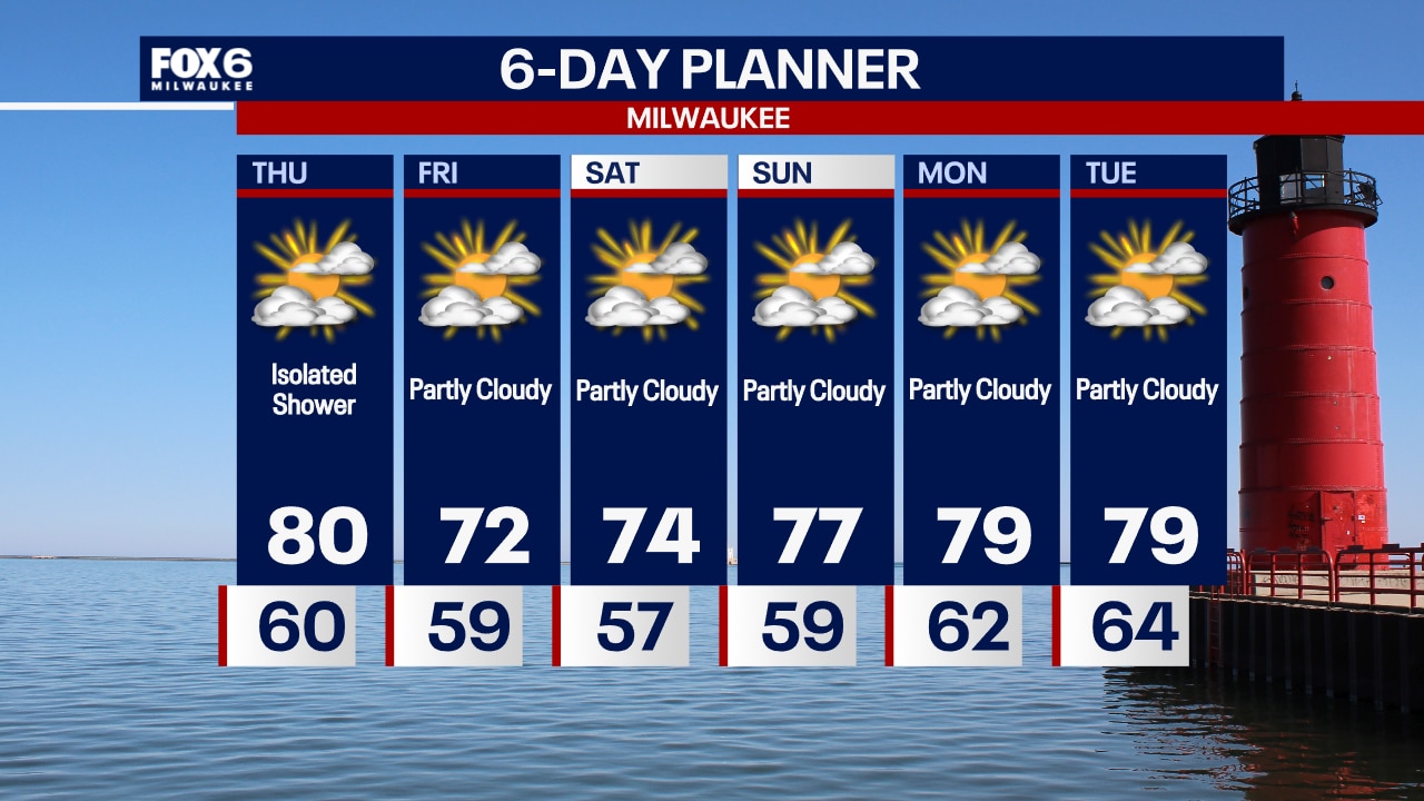
High pressure is still the big player weather-wise today, but with a disturbance to our southwest and another to our northeast today, we could see an isolated afternoon sprinkle. Highs will warm back to seasonal or slightly above today and stay in the near-seasonal range most of the week. We are mostly dry today through Wednesday afternoon, but then we enter a soggy period from Wednesday night through the weekend. We could see 1.5 - 2.0 inches of rain over a few days later this week.
High pressure is still the big player weather-wise today, but with a disturbance to our southwest and another to our northeast today, we could see an isolated afternoon sprinkle. Highs will warm back to seasonal or slightly above today and stay in the near-seasonal range most of the week. We are mostly dry today through Wednesday afternoon, but then we enter a soggy period from Wednesday night through the weekend. We could see 1.5 - 2.0 inches of rain over a few days later this week.

Weather Webcast with Chief Meteorologist Tom Wachs
The Perseid Meteor Shower will be at its peak overnight. Look to the northeast overnight and let your eyes adjust. You might catch several meteors flying across the sky. Partly sunny on Monday with a high around 80.
The Perseid Meteor Shower will be at its peak overnight. Look to the northeast overnight and let your eyes adjust. You might catch several meteors flying across the sky. Partly sunny on Monday with a high around 80.
Weather Webcast with Chief Meteorologist Tom Wachs
Partly cloudy and comfortable tonight. Temperatures dropping into the 60s this evening. The Perseid Meteor Shower peaks overnight. Start looking to the NE after 10pm.
Partly cloudy and comfortable tonight. Temperatures dropping into the 60s this evening. The Perseid Meteor Shower peaks overnight. Start looking to the NE after 10pm.
Weather webcast with Rob Haswell
An area of high pressure building over the area keeps us sunny and dry for a couple of days. Highs today will reach the upper 70s and dew points remain low for that more Fall-like feel.
An area of high pressure building over the area keeps us sunny and dry for a couple of days. Highs today will reach the upper 70s and dew points remain low for that more Fall-like feel.
Weather Webcast with Chief Meteorologist Tom Wachs
Partly cloudy overnight with the Perseid Meteor Shower possible. Temperatures dropping into the 50s. Partly sunny and breezy on Sunday with highs in the mid-to-upper 70s.
Partly cloudy overnight with the Perseid Meteor Shower possible. Temperatures dropping into the 50s. Partly sunny and breezy on Sunday with highs in the mid-to-upper 70s.

Weather Webcast with Chief Meteorologist Tom Wachs
Partly cloudy tonight with the wind settling down. Temperatures will drop through the 60s and settle in the 50s overnight. Partly sunny, breezy and warmer on Sunday. Highs in the mid-to-upper 70s.
Partly cloudy tonight with the wind settling down. Temperatures will drop through the 60s and settle in the 50s overnight. Partly sunny, breezy and warmer on Sunday. Highs in the mid-to-upper 70s.
Weather webcast with Lisa Michaels
Partly sunny Saturday with highs in the low to mid 70s by the afternoon. Breezy at times but cool, comfortable, and dry. Another dry day on Sunday is anticipated with slightly warmer temps pushing into the upper 70s.
Partly sunny Saturday with highs in the low to mid 70s by the afternoon. Breezy at times but cool, comfortable, and dry. Another dry day on Sunday is anticipated with slightly warmer temps pushing into the upper 70s.
Weather webcast with Lisa Michaels
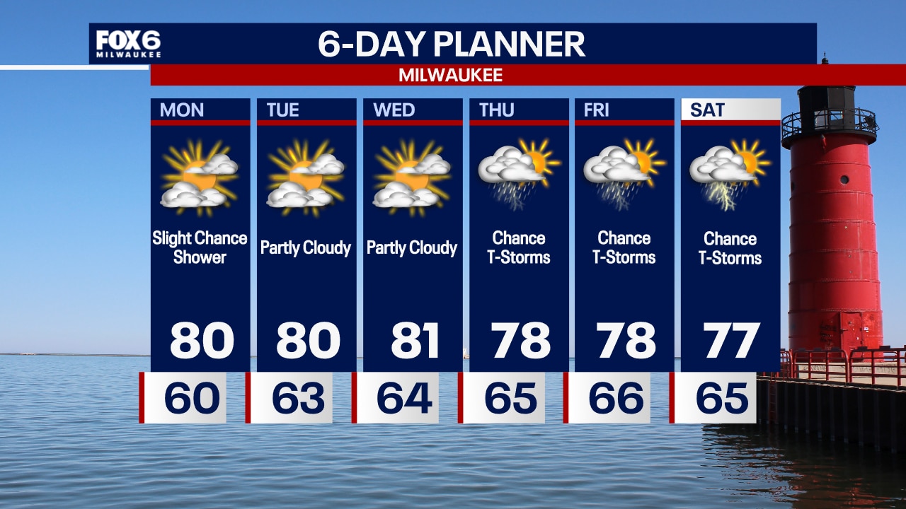
Clouds gradually decrease tonight. Temps will fall into the low 50s inland and mid 50s lakeside by Saturday morning. Mostly sunny and dry conditions this upcoming weekend. Temps will be cooler on Saturday in the low 70s and warmer on Sunday in the upper 70s. This is still below average for this time of year. More near average temps return next week close to 80F with dry days ahead. Next chance for rain could be late Wednesday.
Clouds gradually decrease tonight. Temps will fall into the low 50s inland and mid 50s lakeside by Saturday morning. Mostly sunny and dry conditions this upcoming weekend. Temps will be cooler on Saturday in the low 70s and warmer on Sunday in the upper 70s. This is still below average for this time of year. More near average temps return next week close to 80F with dry days ahead. Next chance for rain could be late Wednesday.
Weather webcast with Rob Haswell
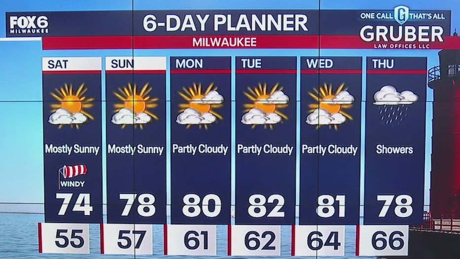
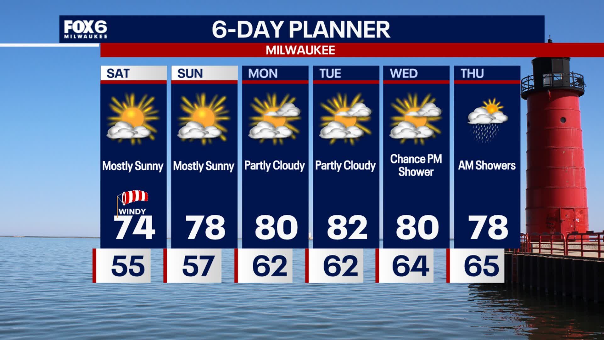
On the backside of a stalled low today we can expect breezy conditions and much cooler temperatures with highs in the low 70s. As areas of instability rotate around the low, we could see a few isolated afternoon and evening showers but most areas stay dry. We should see a clear night and stay dry and sunny on Saturday with just a few more clouds for Sunday. Our next chance for precipitation isn't likely until later Wednesday.
On the backside of a stalled low today we can expect breezy conditions and much cooler temperatures with highs in the low 70s. As areas of instability rotate around the low, we could see a few isolated afternoon and evening showers but most areas stay dry. We should see a clear night and stay dry and sunny on Saturday with just a few more clouds for Sunday. Our next chance for precipitation isn't likely until later Wednesday.

Weather Webcast with Chief Meteorologist Tom Wachs
Mostly clear and breezy overnight with temperatures dropping into the 50s. Partly sunny, windy and cooler on Friday with highs in the low 70s.
Mostly clear and breezy overnight with temperatures dropping into the 50s. Partly sunny, windy and cooler on Friday with highs in the low 70s.
Weather Webcast with Chief Meteorologist Tom Wachs
Partly cloudy and breezy tonight with temperatures dropping into the 60s this evening. Humidity levels will drop overnight allowing temperatures to fall into the 50s. Partly sunny, windy and cooler on Friday with highs in the low 70s.
Partly cloudy and breezy tonight with temperatures dropping into the 60s this evening. Humidity levels will drop overnight allowing temperatures to fall into the 50s. Partly sunny, windy and cooler on Friday with highs in the low 70s.
Weather webcast with Rob Haswell
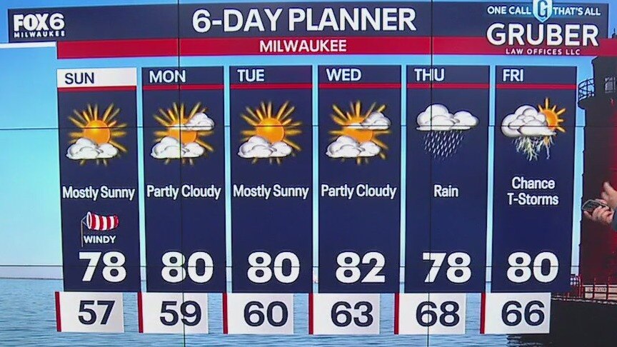
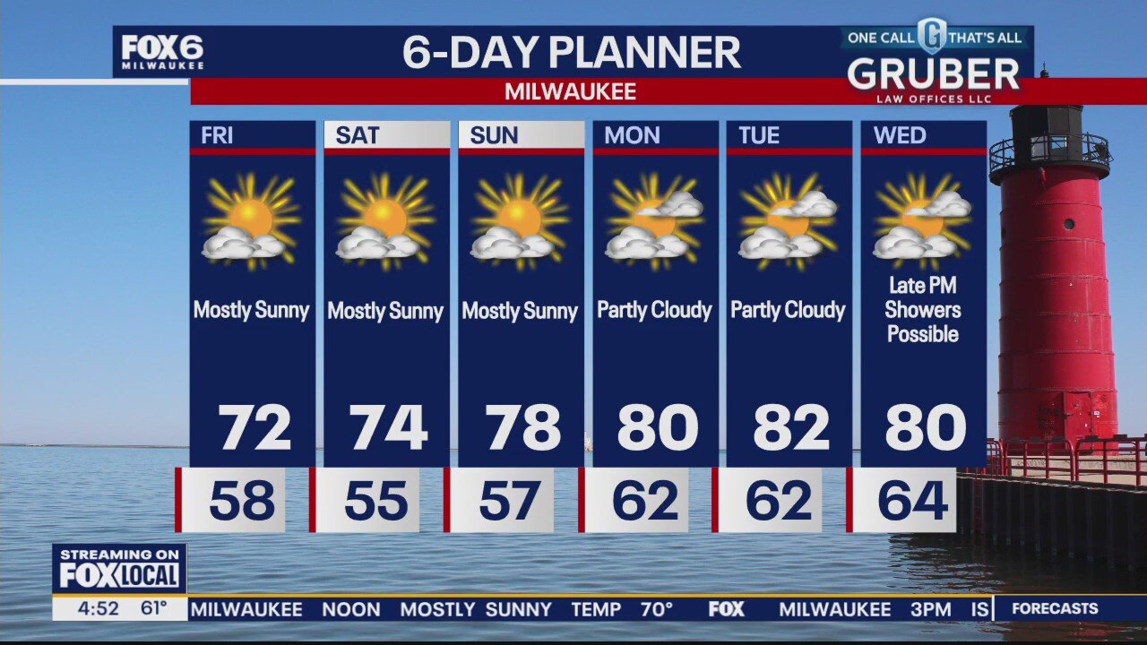
A cold front passes through Wisconsin today. Ahead of that front we warm into the upper 70s to near 80 and cool behind it to the low 70s tomorrow. With the frontal passage comes the chance for a few isolated showers but most areas will stay dry. We remain dry for the rest of the week and into early next week. Highs will remain just lightly below average and overnights will be refreshingly cool.
A cold front passes through Wisconsin today. Ahead of that front we warm into the upper 70s to near 80 and cool behind it to the low 70s tomorrow. With the frontal passage comes the chance for a few isolated showers but most areas will stay dry. We remain dry for the rest of the week and into early next week. Highs will remain just lightly below average and overnights will be refreshingly cool.
Weather Webcast with Chief Meteorologist Tom Wachs
Quiet overnight with temperatures in the 50s to around 60 by sunrise. Partly to mostly cloudy on Thursday with an isolated afternoon rain shower possible. Highs around 80.
Quiet overnight with temperatures in the 50s to around 60 by sunrise. Partly to mostly cloudy on Thursday with an isolated afternoon rain shower possible. Highs around 80.

Weather Webcast with Chief Meteorologist Tom Wachs
Becoming partly cloudy tonight. Temperatures dropping through the 60s. Partly to mostly cloudy on Thursday with a slim chance for a shower and a high around 80.
Becoming partly cloudy tonight. Temperatures dropping through the 60s. Partly to mostly cloudy on Thursday with a slim chance for a shower and a high around 80.

Weather webcast with Lisa Michaels
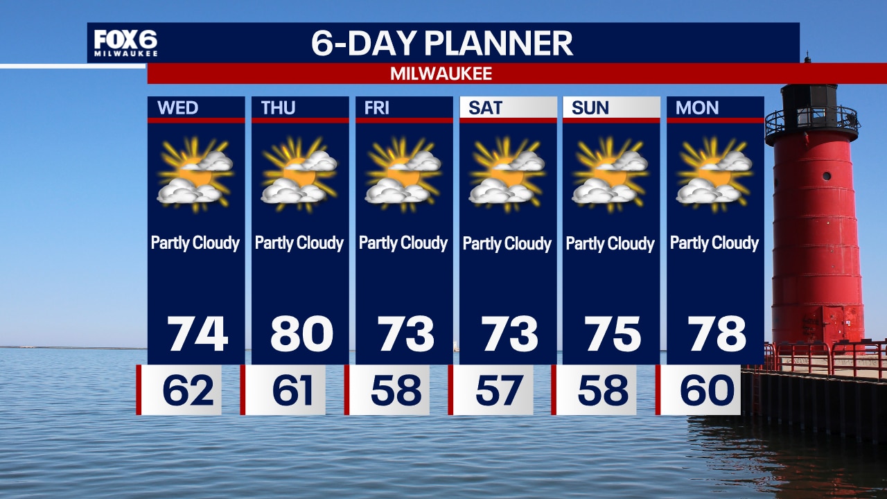
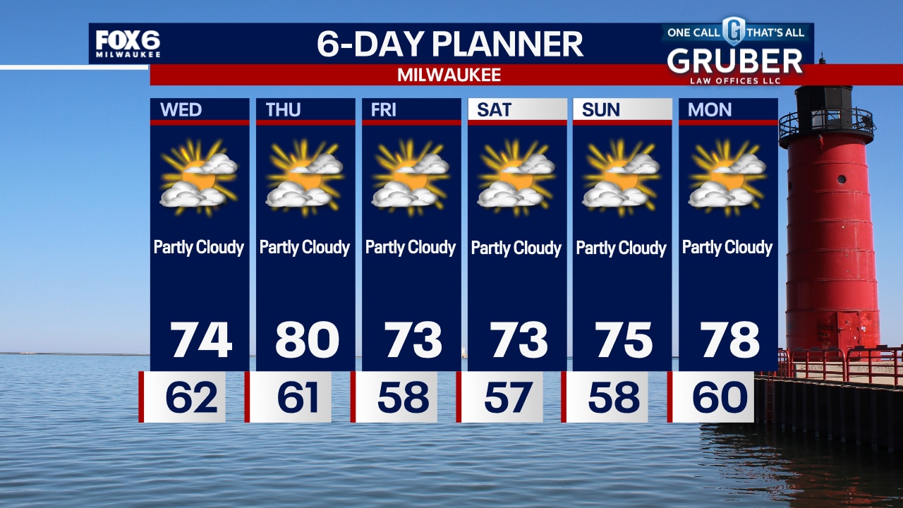
Mostly sunny and cooler on Wednesday with highs in the mid 70s near the lake to upper 70s inland. An approaching cold front on Thursday will bring in a few more clouds with temps reaching the low 80s. A slight chance for a shower in the afternoon. Below average temps and dry conditions for the rest of the week into the weekend.
Mostly sunny and cooler on Wednesday with highs in the mid 70s near the lake to upper 70s inland. An approaching cold front on Thursday will bring in a few more clouds with temps reaching the low 80s. A slight chance for a shower in the afternoon. Below average temps and dry conditions for the rest of the week into the weekend.
Weather webcast with Lisa Michaels
Clouds will continue to decrease tonight. Temps falling in the to upper 50s to low 60s by Wednesday morning. Mostly sunny and cooler on Wednesday with highs in the mid 70s near the lake to upper 70s inland. An approaching cold front on Thursday will bring in a few more clouds with temps reaching the low 80s. A slight chance for a shower in the afternoon. Below average temps and dry conditions for the rest of the week into the weekend.
Clouds will continue to decrease tonight. Temps falling in the to upper 50s to low 60s by Wednesday morning. Mostly sunny and cooler on Wednesday with highs in the mid 70s near the lake to upper 70s inland. An approaching cold front on Thursday will bring in a few more clouds with temps reaching the low 80s. A slight chance for a shower in the afternoon. Below average temps and dry conditions for the rest of the week into the weekend.
Weather Webcast with Chief Meteorologist Tom Wachs
Clearing skies overnight and comfortable. Lows in the mid-50s inland, low 60s near the lake. Partly sunny with lower humidity levels on Wednesday. Highs in the low-to-mid 70s.
Clearing skies overnight and comfortable. Lows in the mid-50s inland, low 60s near the lake. Partly sunny with lower humidity levels on Wednesday. Highs in the low-to-mid 70s.
Weather Webcast with Chief Meteorologist Tom Wachs
Clearing skies and dropping humidity levels tonight. Temperatures will drop through the 60s this evening and into the 50s away from the lake overnight. Partly sunny on Wednesday with a high in the low-to-mid 70s.
Clearing skies and dropping humidity levels tonight. Temperatures will drop through the 60s this evening and into the 50s away from the lake overnight. Partly sunny on Wednesday with a high in the low-to-mid 70s.
Weather webcast with Lisa Michaels
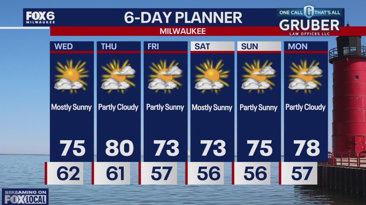
Clearing skies tonight as high pressure moves in. Temperatures dropping through the 60s this evening and settling in the 50s inland overnight, low 60s near the lake. Partly sunny on Wednesday with highs in the mid-70s and comfortable dew points in the 50s. Warming up on Thursday with a touch of humidity. High around 80 with dew points in the low 60s. A cold front will move through on Thursday. Cooler and less humid Friday into the weekend. Highs in the 70s with dew points in the 50s. No major storm systems in sight.
Clearing skies tonight as high pressure moves in. Temperatures dropping through the 60s this evening and settling in the 50s inland overnight, low 60s near the lake. Partly sunny on Wednesday with highs in the mid-70s and comfortable dew points in the 50s. Warming up on Thursday with a touch of humidity. High around 80 with dew points in the low 60s. A cold front will move through on Thursday. Cooler and less humid Friday into the weekend. Highs in the 70s with dew points in the 50s. No major storm systems in sight.