

Weather webcast with Lisa Michaels
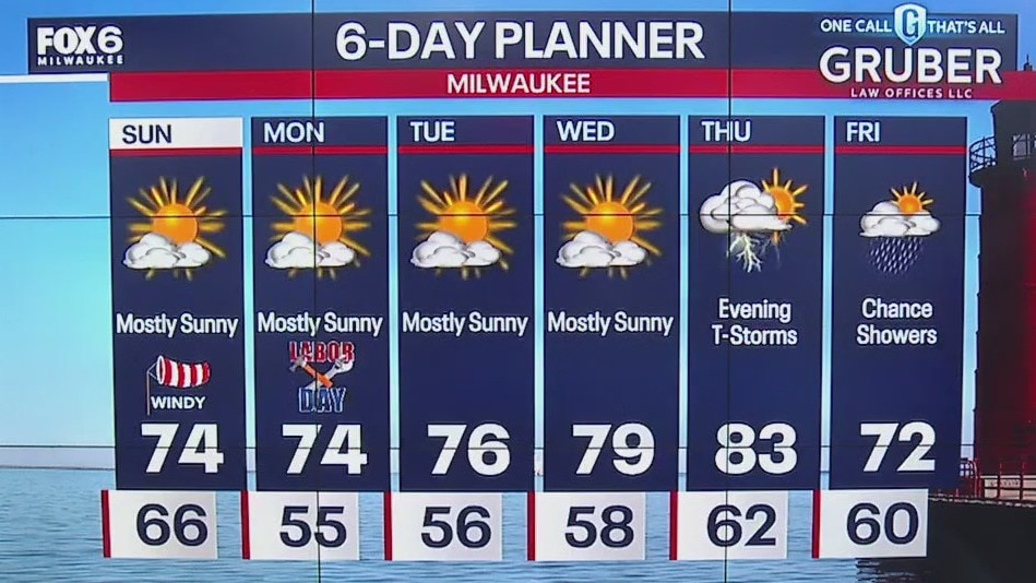
Sunny Sunday with cooler high temps in the mid 70s. Northeast winds will cause dangerous swim conditions for Milwaukee, Racine, and Kenosha counties. More sunshine continues into next week.
Sunny Sunday with cooler high temps in the mid 70s. Northeast winds will cause dangerous swim conditions for Milwaukee, Racine, and Kenosha counties. More sunshine continues into next week.
Weather Webcast with Stephanie Barichello
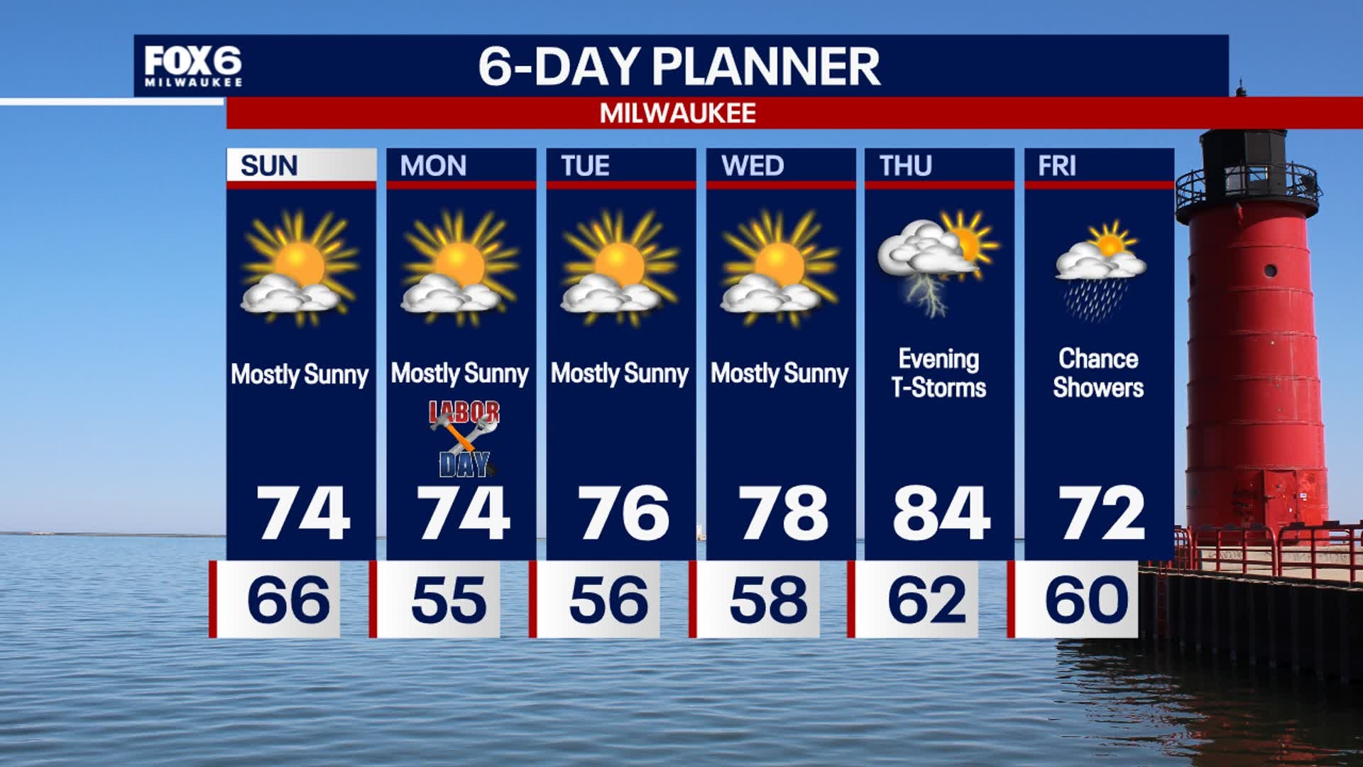
Another sunny and gorgeous day ahead Sunday! It'll be breezy and cooler with temperatures in the low 70s. Similar Monday but less wind. Gradually warming next week, with the warmest day in the 80s on Thursday. A cold front will bring storms Thursday evening into Friday and cool us back to 70s.
Another sunny and gorgeous day ahead Sunday! It'll be breezy and cooler with temperatures in the low 70s. Similar Monday but less wind. Gradually warming next week, with the warmest day in the 80s on Thursday. A cold front will bring storms Thursday evening into Friday and cool us back to 70s.
Weather webcast with Lisa Michaels
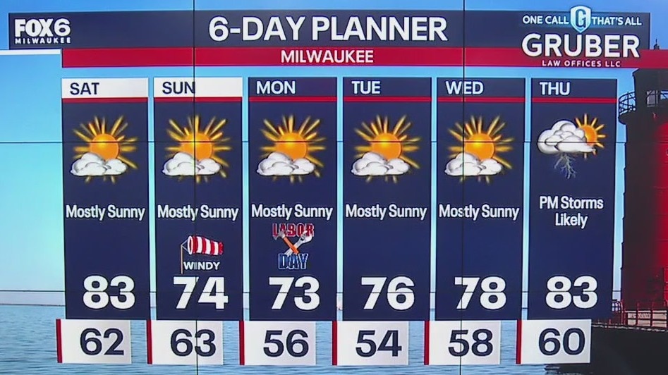
Wonderful Labor Day Weekend Ahead! Saturday will be mostly sunny with highs in the low 80s. Dew points in the low 60s. A dry cold front moves through Saturday night into Sunday bringing another round of cooler temps and drier air by Sunday and Monday.
Wonderful Labor Day Weekend Ahead! Saturday will be mostly sunny with highs in the low 80s. Dew points in the low 60s. A dry cold front moves through Saturday night into Sunday bringing another round of cooler temps and drier air by Sunday and Monday.

Weather Webcast with Stephanie Barichello
Clouds clear tonight, then plenty of sunshine in the days ahead! Warm on Saturday with highs in the 80s, then a lake breeze will cool us into the 70s the rest of the holiday weekend. Chance for storms next Thursday.
Clouds clear tonight, then plenty of sunshine in the days ahead! Warm on Saturday with highs in the 80s, then a lake breeze will cool us into the 70s the rest of the holiday weekend. Chance for storms next Thursday.
Weather webcast with Lisa Michaels
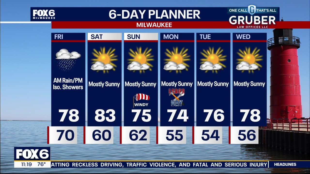
Clouds through the rest of the day with isolated showers possible in the afternoon. Decreasing rain/clouds late Friday. Humid on Friday with highs in the upper 70s. Lower dew points arrive late Friday and into the weekend. A dry and mostly sunny holiday weekend! Saturday will be slightly warmer in the low 80s with mid-70s on Sunday and Monday. More cool, dry, and comfortable days next week!
Clouds through the rest of the day with isolated showers possible in the afternoon. Decreasing rain/clouds late Friday. Humid on Friday with highs in the upper 70s. Lower dew points arrive late Friday and into the weekend. A dry and mostly sunny holiday weekend! Saturday will be slightly warmer in the low 80s with mid-70s on Sunday and Monday. More cool, dry, and comfortable days next week!
Weather webcast with Lisa Michaels
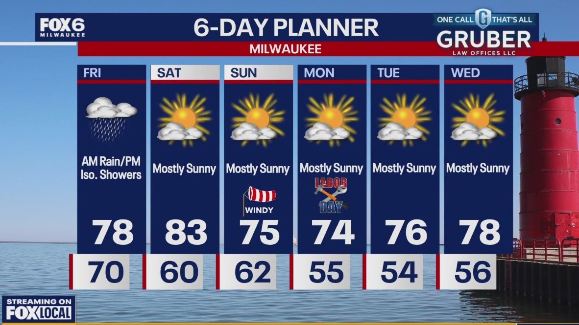
Rain in the morning on Friday. Clouds through the rest of the day with isolated showers possible in the afternoon. Decreasing rain/clouds late Friday. Humid on Friday with highs in the upper 70s. Lower dew points arrive late Friday and into the weekend. A dry and mostly sunny holiday weekend! Saturday will be slightly warmer in the low 80s with mid-70s on Sunday and Monday. More cool, dry, and comfortable days next week!
Rain in the morning on Friday. Clouds through the rest of the day with isolated showers possible in the afternoon. Decreasing rain/clouds late Friday. Humid on Friday with highs in the upper 70s. Lower dew points arrive late Friday and into the weekend. A dry and mostly sunny holiday weekend! Saturday will be slightly warmer in the low 80s with mid-70s on Sunday and Monday. More cool, dry, and comfortable days next week!

Weather Webcast with Chief Meteorologist Tom Wachs
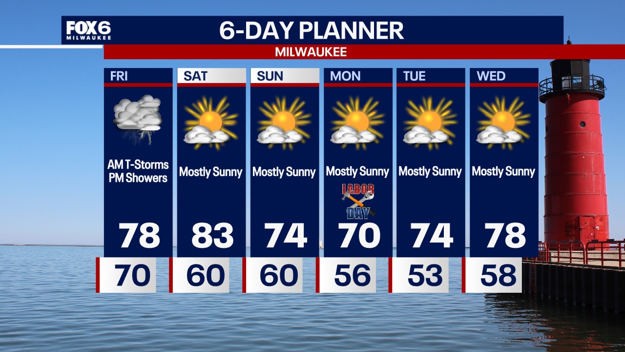
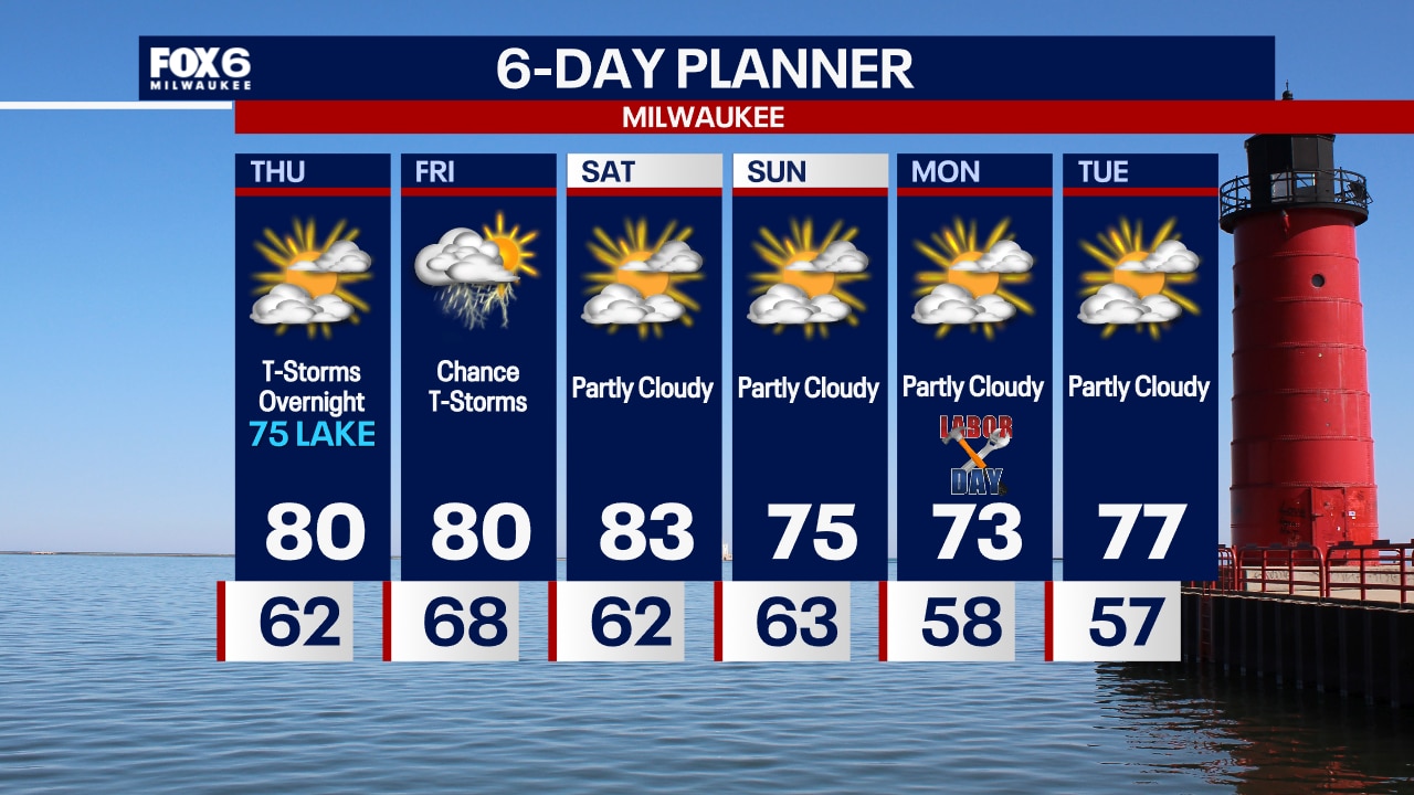
Showers and t-storms moving in from the west after 3am. The steady rain will end by 9am. Spotty light afternoon rain showers with high temperatures in the upper 70s to around 80.
Showers and t-storms moving in from the west after 3am. The steady rain will end by 9am. Spotty light afternoon rain showers with high temperatures in the upper 70s to around 80.
Weather Webcast with Chief Meteorologist Tom Wachs
Becoming partly cloudy this evening, humid with temperatures in the 70s. Thunderstorms move in from the west after 3am. Rainy for the AM commute Friday. Daytime highs in the upper 70s.
Becoming partly cloudy this evening, humid with temperatures in the 70s. Thunderstorms move in from the west after 3am. Rainy for the AM commute Friday. Daytime highs in the upper 70s.
Weather webcast with Stephanie Barichello
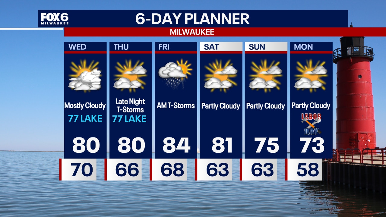
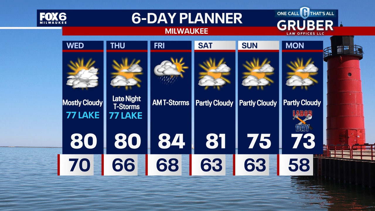
Clouds and some patchy fog to start this morning, then becoming partly sunny this afternoon. Humid, with temperatures in the upper 70s lakeside to low 80s inland. Rain showers and thunderstorms are likely on Friday, then drying out Saturday. Highs will reach into the low 80s with dropping dewpoints. Cooler and much more comfortable through Labor Day!
Clouds and some patchy fog to start this morning, then becoming partly sunny this afternoon. Humid, with temperatures in the upper 70s lakeside to low 80s inland. Rain showers and thunderstorms are likely on Friday, then drying out Saturday. Highs will reach into the low 80s with dropping dewpoints. Cooler and much more comfortable through Labor Day!

Weather Webcast with Chief Meteorologist Tom Wachs
Patchy fog overnight with temperatures in the 60s. Becoming partly sunny on Thursday with highs in the 70s near the lake, low 80s inland. T-Storm chances return overnight Thursday night.
Patchy fog overnight with temperatures in the 60s. Becoming partly sunny on Thursday with highs in the 70s near the lake, low 80s inland. T-Storm chances return overnight Thursday night.
Weather Webcast with Chief Meteorologist Tom Wachs
A few spotty rain showers possible this evening, otherwise patchy fog overnight with temperatures in the 60s. Partly sunny on Thursday with highs in the mid-70s to around 80. T-Storms return late Thursday night and Friday morning.
A few spotty rain showers possible this evening, otherwise patchy fog overnight with temperatures in the 60s. Partly sunny on Thursday with highs in the mid-70s to around 80. T-Storms return late Thursday night and Friday morning.
Weather webcast with Stephanie Barichello
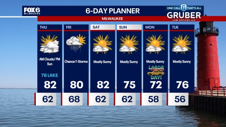
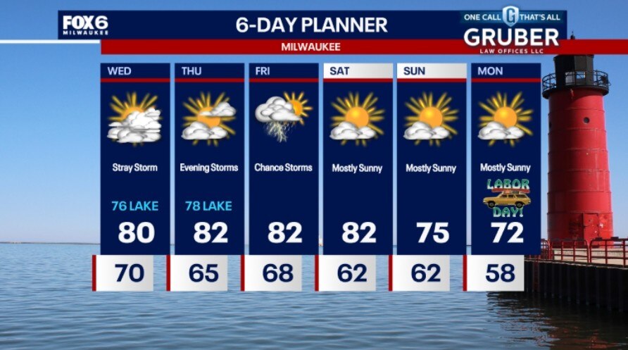
Partly to mostly cloudy today with a stray shower or storm possible. It'll still be humid with but cooler with temperatures in the 70s lakeside to around 80 inland. Temperatures drop into the 60s tonight. Similar on Thursday with rain and storms returning in the evening. Storms will continue into Friday morning, with a chance in the afternoon, as well. A nice, sunny stretch ahead for the holiday weekend. Temperatures will fall into the low 70s with no humidity by Labor Day.
Partly to mostly cloudy today with a stray shower or storm possible. It'll still be humid with but cooler with temperatures in the 70s lakeside to around 80 inland. Temperatures drop into the 60s tonight. Similar on Thursday with rain and storms returning in the evening. Storms will continue into Friday morning, with a chance in the afternoon, as well. A nice, sunny stretch ahead for the holiday weekend. Temperatures will fall into the low 70s with no humidity by Labor Day.
Weather Webcast with Chief Meteorologist Tom Wachs
Patchy fog overnight with a slight chance for a t-storm. Temperatures in the 70s. Mostly cloudy, cooler but still humid on Wednesday. 70s near the lake, 80s inland and south.
Patchy fog overnight with a slight chance for a t-storm. Temperatures in the 70s. Mostly cloudy, cooler but still humid on Wednesday. 70s near the lake, 80s inland and south.
Weather Webcast with Chief Meteorologist Tom Wachs
Scattered t-storms possible this evening, staying humid. Temperatures in the 70s. Cooler but still humid on Wednesday and dry. Highs in the 70s near the lake, 80s inland.
Scattered t-storms possible this evening, staying humid. Temperatures in the 70s. Cooler but still humid on Wednesday and dry. Highs in the 70s near the lake, 80s inland.
Weather webcast with Rob Haswell
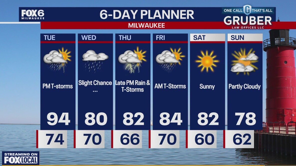
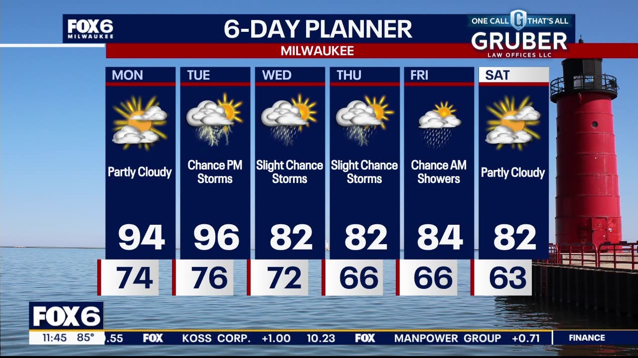
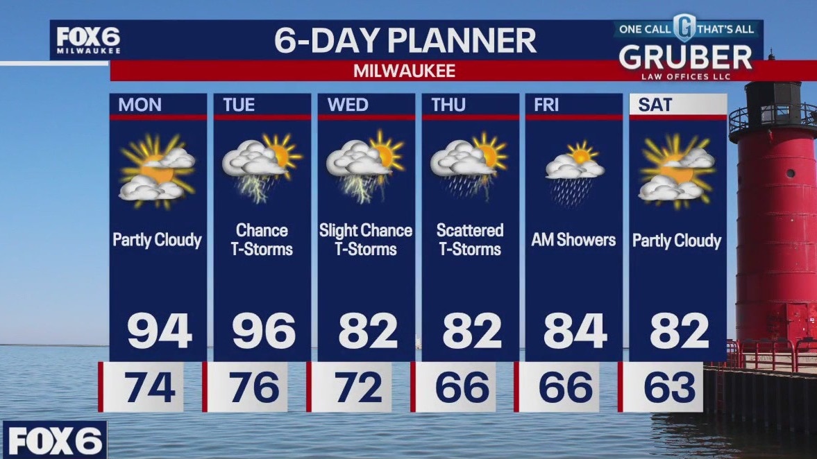
Another hot and humid day today with an Excessive Heat Warning for most areas and a Heat Advisory for our north counties. Highs today will reach the low 90s yet again and feel between 100-105 or higher at times. There is a risk for thunderstorms later this afternoon and evening. Strong to severe storms are possible. Cooler and less humid air arrives by Wednesday.
Another hot and humid day today with an Excessive Heat Warning for most areas and a Heat Advisory for our north counties. Highs today will reach the low 90s yet again and feel between 100-105 or higher at times. There is a risk for thunderstorms later this afternoon and evening. Strong to severe storms are possible. Cooler and less humid air arrives by Wednesday.
Weather Webcast with Chief Meteorologist Tom Wachs
Strong storms possible north of Milwaukee overnight, otherwise warm and humid. Excessive Heat Warning on Tuesday with a heat index of 108. Strong storms possible Tuesday afternoon.
Strong storms possible north of Milwaukee overnight, otherwise warm and humid. Excessive Heat Warning on Tuesday with a heat index of 108. Strong storms possible Tuesday afternoon.
Weather Webcast with Chief Meteorologist Tom Wachs
Warm and humid tonight with temperatures not getting much below 80 in Milwaukee overnight. Excessive Heat Warning on Tuesday. Heat Index around 108 Tuesday afternoon. Strong afternoon t-storms are also possible.
Warm and humid tonight with temperatures not getting much below 80 in Milwaukee overnight. Excessive Heat Warning on Tuesday. Heat Index around 108 Tuesday afternoon. Strong afternoon t-storms are also possible.
Weather webcast with Lisa Michaels
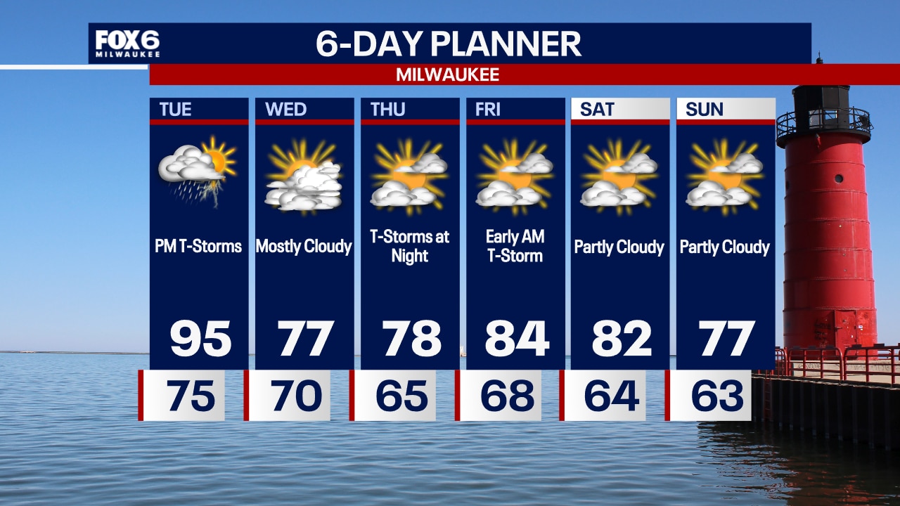
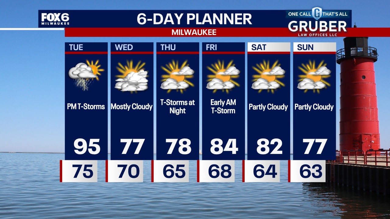
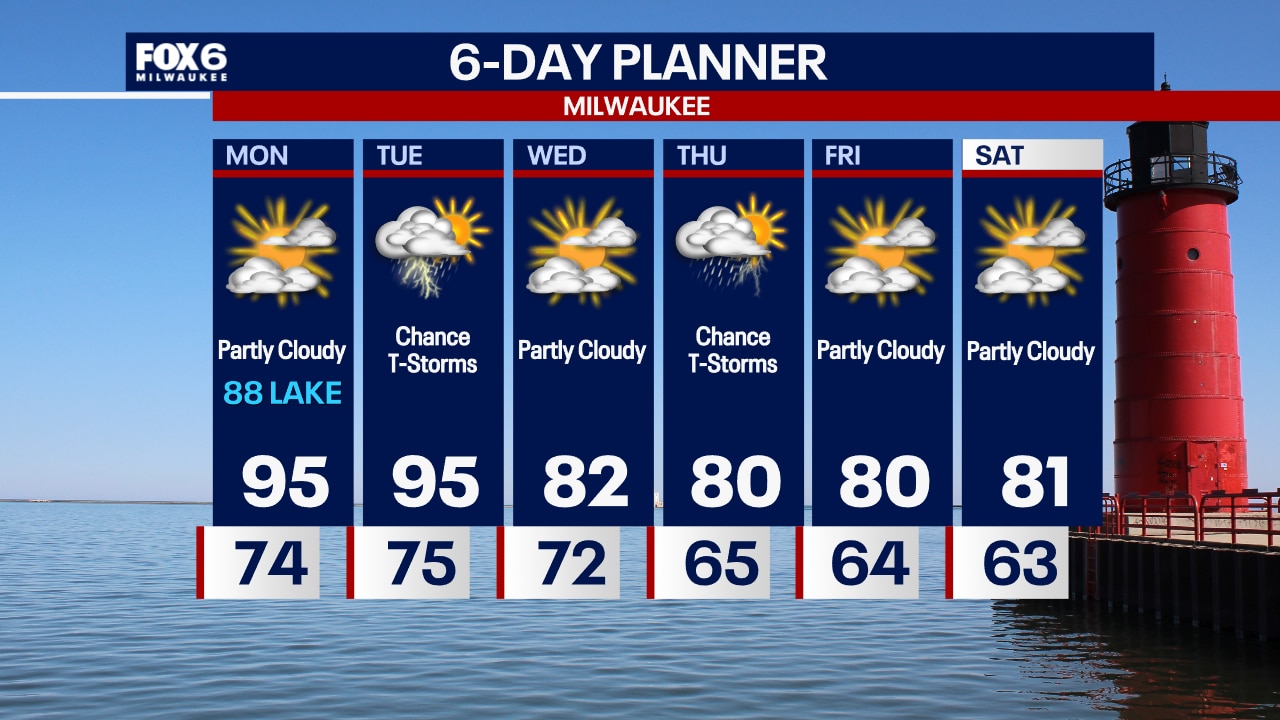
Very hot and humid for the next few days. Heat Advisories along with Excessive Heat Warnings and Watches are in place. Highs today will reach the low to mid 90s but with dew point readings in the 70s, it will feel more like 100 or higher. We remain hot through Tuesday but should return to near average temperatures mid to late week. There is a risk for thunderstorms tonight and Tuesday. Some of those storms could be severe.
Very hot and humid for the next few days. Heat Advisories along with Excessive Heat Warnings and Watches are in place. Highs today will reach the low to mid 90s but with dew point readings in the 70s, it will feel more like 100 or higher. We remain hot through Tuesday but should return to near average temperatures mid to late week. There is a risk for thunderstorms tonight and Tuesday. Some of those storms could be severe.
Weather webcast with Rob Haswell
Very hot and humid for the next few days. Heat Advisories along with Excessive Heat Warnings and Watches are in place. Highs today will reach the low to mid 90s but with dew point readings in the 70s, it will feel more like 100 or higher. We remain hot through Tuesday but should return to near average temperatures mid to late week. There is a risk for thunderstorms tonight and Tuesday. Some of those storms could be severe.
Very hot and humid for the next few days. Heat Advisories along with Excessive Heat Warnings and Watches are in place. Highs today will reach the low to mid 90s but with dew point readings in the 70s, it will feel more like 100 or higher. We remain hot through Tuesday but should return to near average temperatures mid to late week. There is a risk for thunderstorms tonight and Tuesday. Some of those storms could be severe.
Weather Webcast with Chief Meteorologist Tom Wachs
Hot and humid on Monday and Tuesday. Highs in the 90s with a heat index over 100...especially away from the lake. T-Storms are possible on Tuesday.
Hot and humid on Monday and Tuesday. Highs in the 90s with a heat index over 100...especially away from the lake. T-Storms are possible on Tuesday.