

Weather Webcast with Chief Meteorologist Tom Wachs
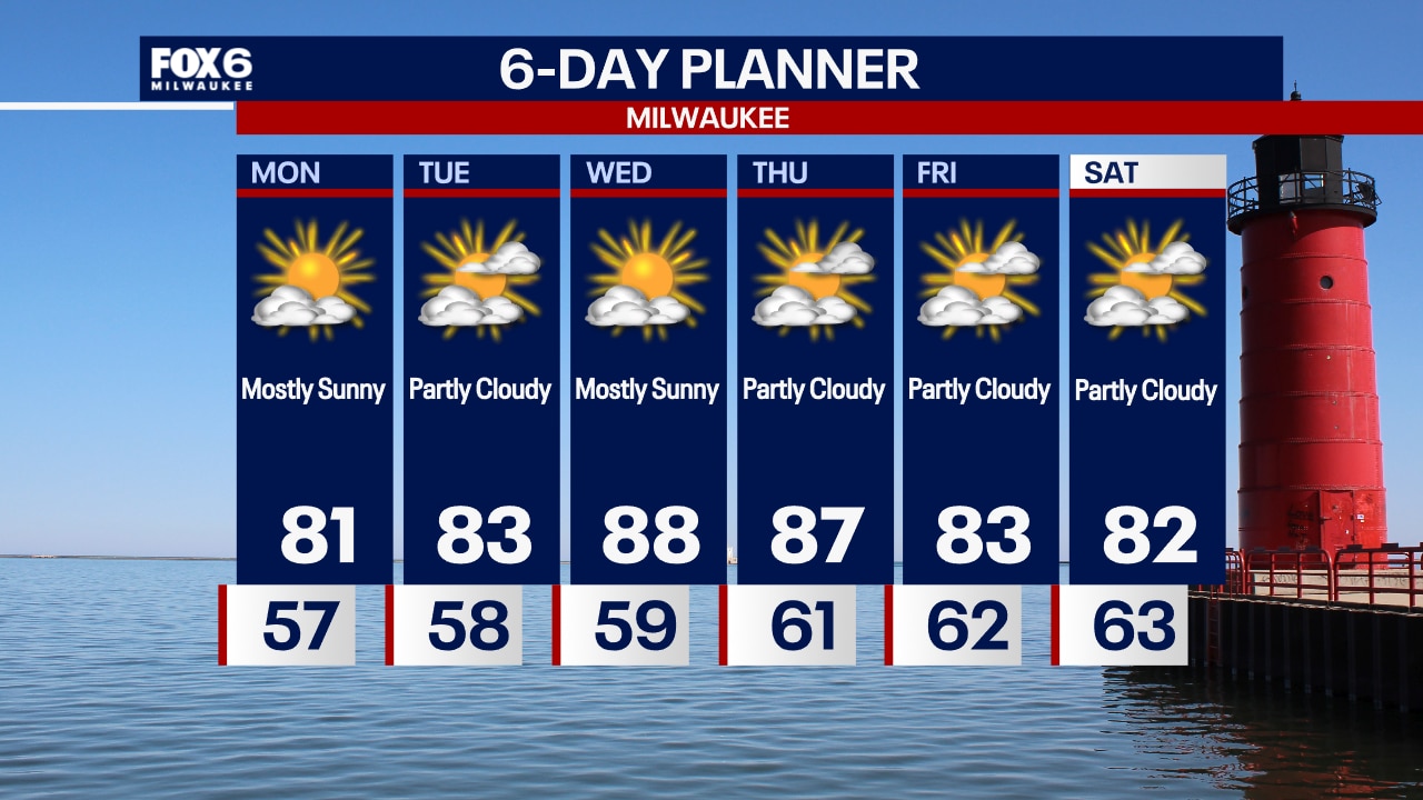
Clear and breezy tonight with temperatures dropping through the 60s. Mostly sunny, breezy and warmer on Monday with highs in the low 80s.
Clear and breezy tonight with temperatures dropping through the 60s. Mostly sunny, breezy and warmer on Monday with highs in the low 80s.
Weather webcast with Rob Haswell
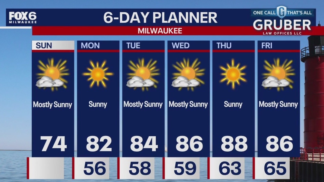
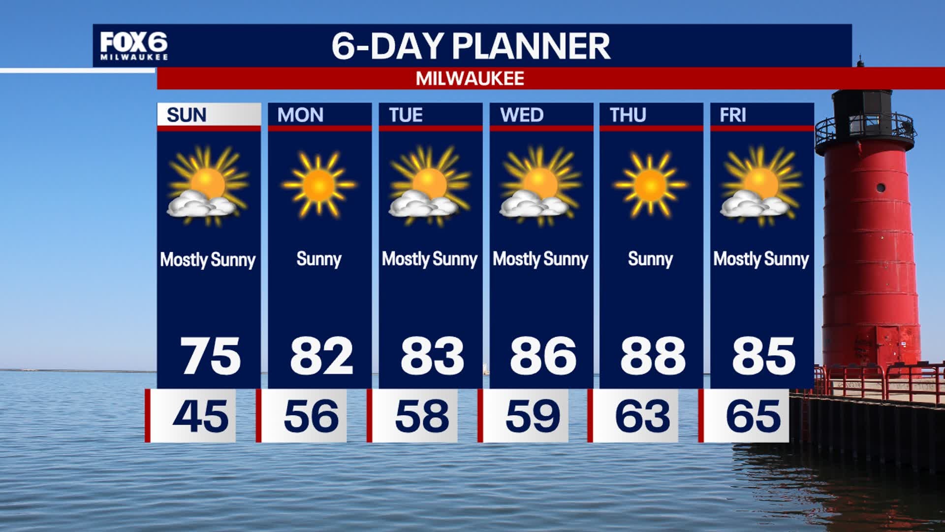
Mostly clear skies tonight with another cool evening as temps will drop into the low to mid 40s by Sunday morning. Mostly sunny skies on Sunday with high temps slightly warmer in the low to mid 70s. Winds begin to change out of the south heading into next week.
Mostly clear skies tonight with another cool evening as temps will drop into the low to mid 40s by Sunday morning. Mostly sunny skies on Sunday with high temps slightly warmer in the low to mid 70s. Winds begin to change out of the south heading into next week.
Weather webcast with Lisa Michaels
Mostly clear skies tonight with another cool evening as temps will drop into the low to mid 40s by Sunday morning. Mostly sunny skies on Sunday with high temps slightly warmer in the low to mid 70s. Winds begin to change out of the south heading into next week. This will continue to bring a warming trend back into the upper 80s by the end of next week! A long dry and sunny stretch of weather will be with us all week.
Mostly clear skies tonight with another cool evening as temps will drop into the low to mid 40s by Sunday morning. Mostly sunny skies on Sunday with high temps slightly warmer in the low to mid 70s. Winds begin to change out of the south heading into next week. This will continue to bring a warming trend back into the upper 80s by the end of next week! A long dry and sunny stretch of weather will be with us all week.
Weather webcast with Rob Haswell
High pressure to our west and a low far to our east are combining to ramp up our wind from the north today. As a result, we will see cold air continue to flood our area with highs in the low to mid 60s today.
High pressure to our west and a low far to our east are combining to ramp up our wind from the north today. As a result, we will see cold air continue to flood our area with highs in the low to mid 60s today.
Weather webcast with Lisa Michaels
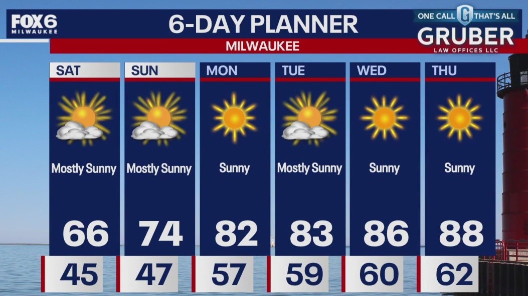
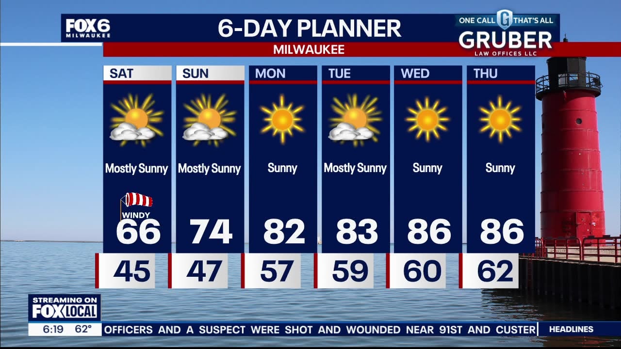
Cool with lows in the low to mid 40s. A few upper 30s inland are possible into Saturday morning. Mostly sunny and cool on Saturday. Highs in the mid 60s with winds off the lake creating dangerous swim conditions through Saturday afternoon due to high waves and rip currents. Mostly sunny on Sunday with highs back in the middle 70s. Warming back into the low and mid 80s next week with more dry days in sight!
Cool with lows in the low to mid 40s. A few upper 30s inland are possible into Saturday morning. Mostly sunny and cool on Saturday. Highs in the mid 60s with winds off the lake creating dangerous swim conditions through Saturday afternoon due to high waves and rip currents. Mostly sunny on Sunday with highs back in the middle 70s. Warming back into the low and mid 80s next week with more dry days in sight!
Weather webcast with Rob Haswell
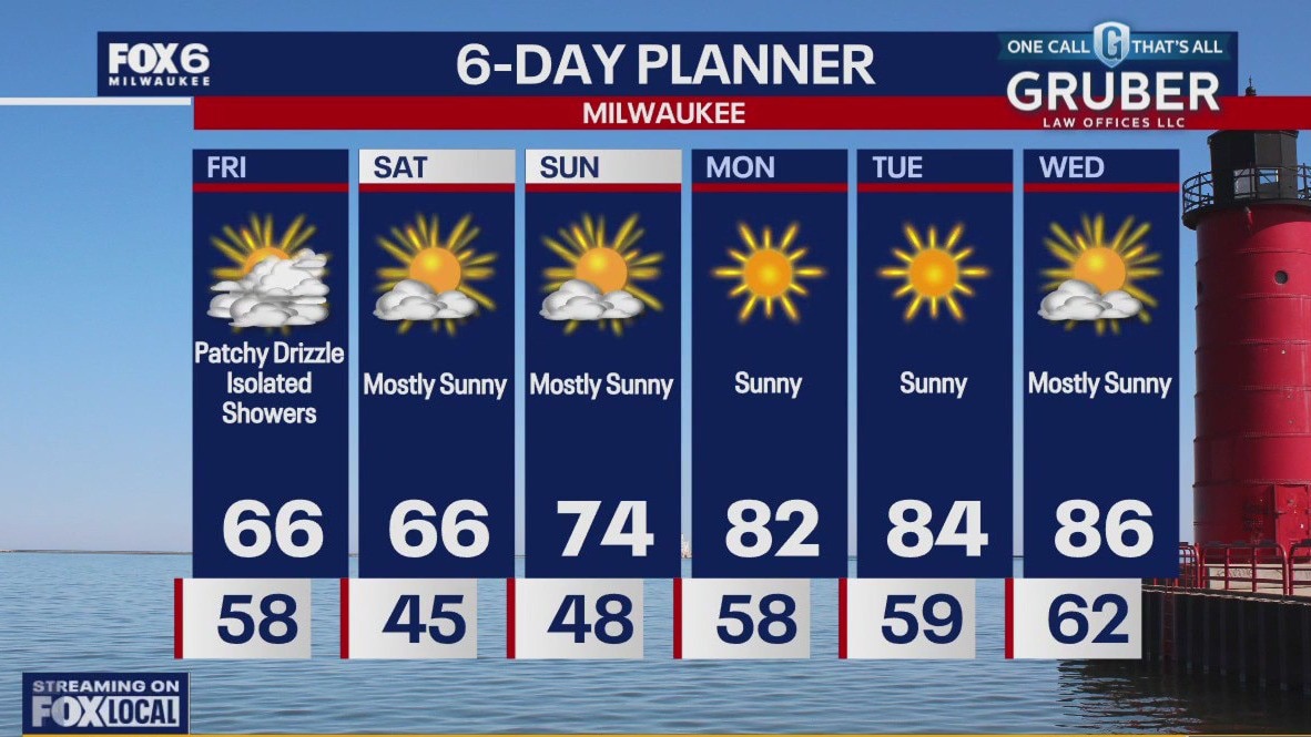
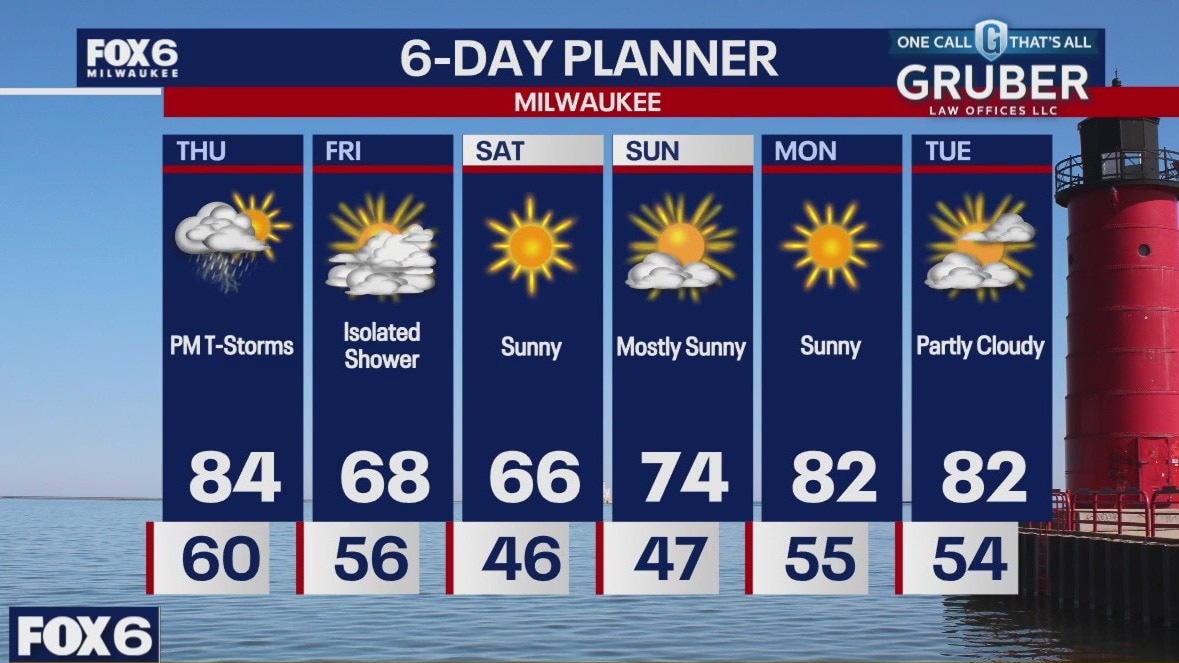
Behind yesterday's low, we remain cloudy with drizzle and a chance for a few showers but the biggest impact is the change in temperatures. We will be in the low to mid 60s this afternoon after hitting 86 yesterday at MKE. The steady NNW wind will make it feel cooler as well. The windy conditions will make for high waves and rough currents in Lake Michigan and NWS has issued a Beach Hazards Statement for our lakeshore areas. We will be cool again tomorrow but rebound back to the low to mid 80s by next week.
Behind yesterday's low, we remain cloudy with drizzle and a chance for a few showers but the biggest impact is the change in temperatures. We will be in the low to mid 60s this afternoon after hitting 86 yesterday at MKE. The steady NNW wind will make it feel cooler as well. The windy conditions will make for high waves and rough currents in Lake Michigan and NWS has issued a Beach Hazards Statement for our lakeshore areas. We will be cool again tomorrow but rebound back to the low to mid 80s by next week.
Weather Webcast with Chief Meteorologist Tom Wachs
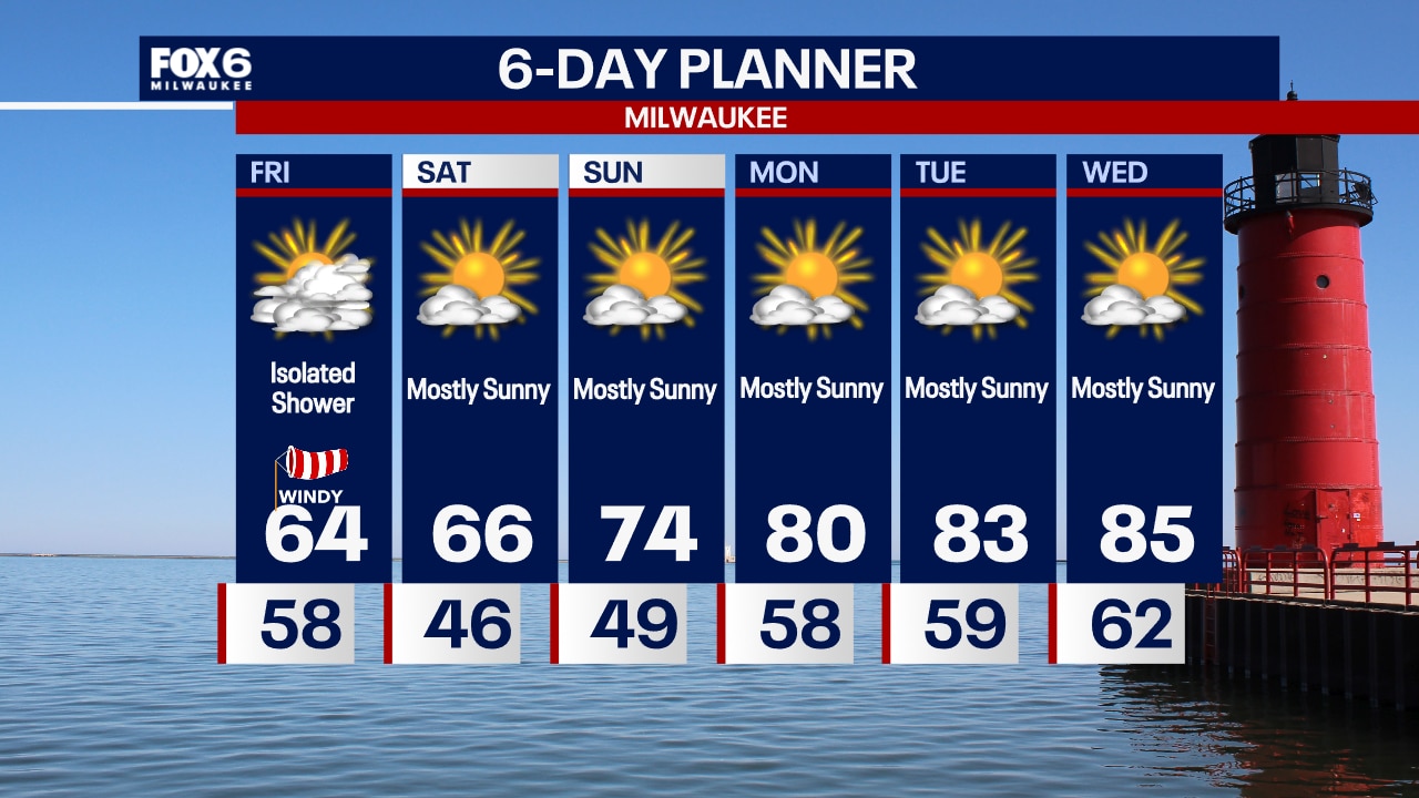
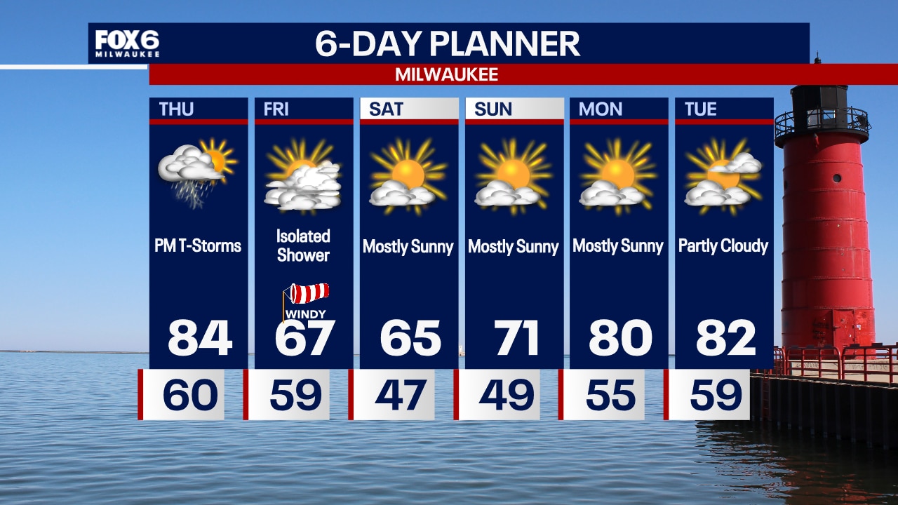
Windy and cooler on Friday with an isolated rain shower possible. Highs in the mid-60s. Very fall-like Friday evening with temperatures in the 50s. Abundant sunshine this weekend.
Windy and cooler on Friday with an isolated rain shower possible. Highs in the mid-60s. Very fall-like Friday evening with temperatures in the 50s. Abundant sunshine this weekend.
Weather Webcast with Chief Meteorologist Tom Wachs
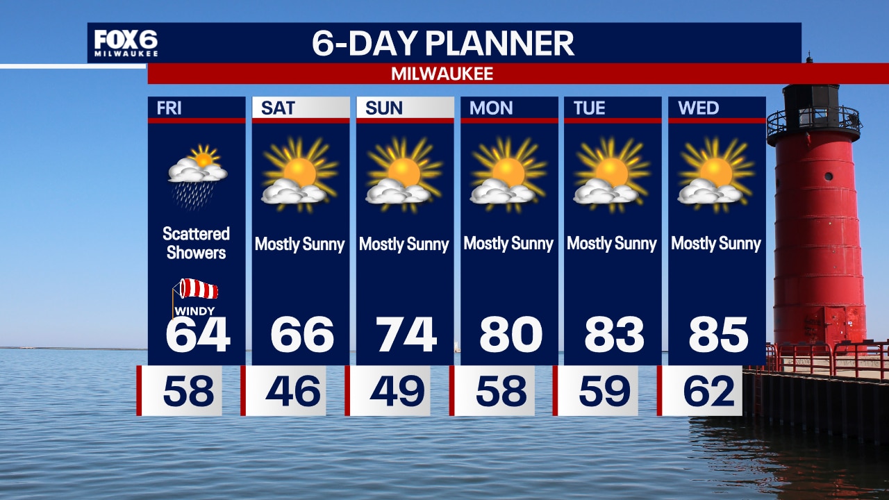
Becoming partly cloudy tonight with a slight chance for a rain shower. Temperatures dropping into the 60s with a northwest breeze. Mostly cloudy, windy and cooler on Friday with scattered showers.
Becoming partly cloudy tonight with a slight chance for a rain shower. Temperatures dropping into the 60s with a northwest breeze. Mostly cloudy, windy and cooler on Friday with scattered showers.
Weather webcast with Rob Haswell
A cold front drops from Minnesota, across us and into Michigan over the next twenty-four hours. Ahead of that front, we will warm on a strong southwesterly wind and hit highs in the low 80s - our warmest day of the month so far. As the front passes through, it will generate some rain and a chance for a few thunderstorms in the evening and overnight. Behind the front we clear out with highs falling into the mid to upper sixties for a couple of days.
A cold front drops from Minnesota, across us and into Michigan over the next twenty-four hours. Ahead of that front, we will warm on a strong southwesterly wind and hit highs in the low 80s - our warmest day of the month so far. As the front passes through, it will generate some rain and a chance for a few thunderstorms in the evening and overnight. Behind the front we clear out with highs falling into the mid to upper sixties for a couple of days.

Weather Webcast with Chief Meteorologist Tom Wachs
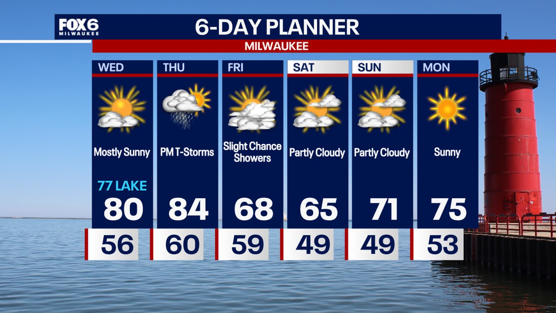
Clear skies overnight with a low around 60. Increasing clouds on Thursday with afternoon/evening showers and a few rumbles of thunder. Highs in the mid-80s.
Clear skies overnight with a low around 60. Increasing clouds on Thursday with afternoon/evening showers and a few rumbles of thunder. Highs in the mid-80s.
Weather Webcast with Chief Meteorologist Tom Wachs
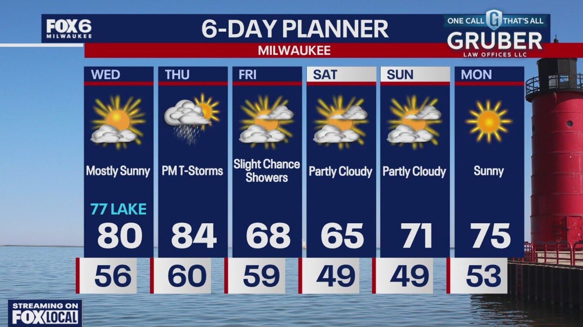
Clear skies tonight with temperatures falling through the 60s. Increasing clouds on Thursday with afternoon/evening showers and t-storms. Highs in the mid-80s.
Clear skies tonight with temperatures falling through the 60s. Increasing clouds on Thursday with afternoon/evening showers and t-storms. Highs in the mid-80s.
Weather Webcast with Stephanie Barichello
Sunny again today, then a chance for showers and storms returns Thursday afternoon and evening along a cold front. A few showers may linger Friday, plus much cooler, then a fall-like weekend ahead with temperatures in the 60s and low 70s.
Sunny again today, then a chance for showers and storms returns Thursday afternoon and evening along a cold front. A few showers may linger Friday, plus much cooler, then a fall-like weekend ahead with temperatures in the 60s and low 70s.
Weather webcast with Lisa Michaels
More sunshine and dry weather on Wednesday with high temps slowly warming into the upper 70s near the lake to low 80s inland. Warmer and humid Thursday with a chance for storms in the evening as a cold front passes. Light rain will also be possible Friday before the system fully exits. Friday will mainly be mostly cloudy with highs in the upper 60s. A true taste of fall Saturday with mid 60s for highs, then warming back into the 70s by Sunday.
More sunshine and dry weather on Wednesday with high temps slowly warming into the upper 70s near the lake to low 80s inland. Warmer and humid Thursday with a chance for storms in the evening as a cold front passes. Light rain will also be possible Friday before the system fully exits. Friday will mainly be mostly cloudy with highs in the upper 60s. A true taste of fall Saturday with mid 60s for highs, then warming back into the 70s by Sunday.
Weather Webcast with Chief Meteorologist Tom Wachs
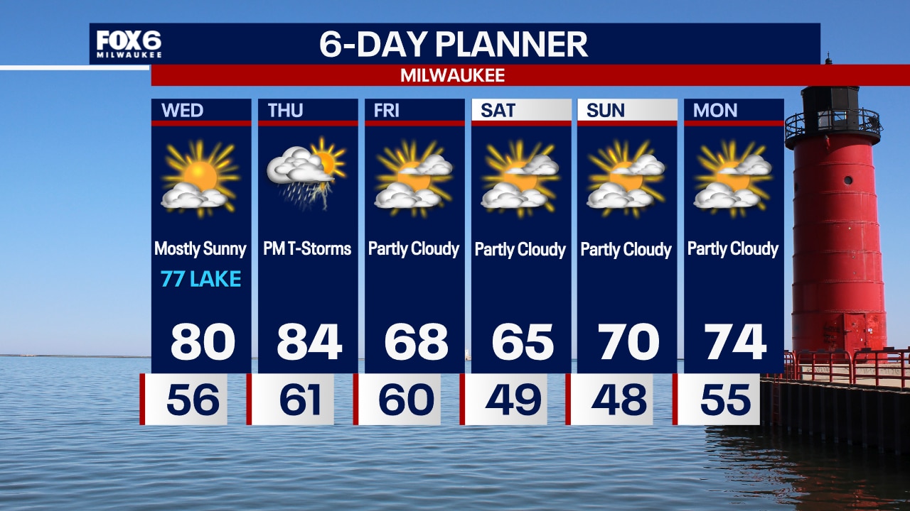
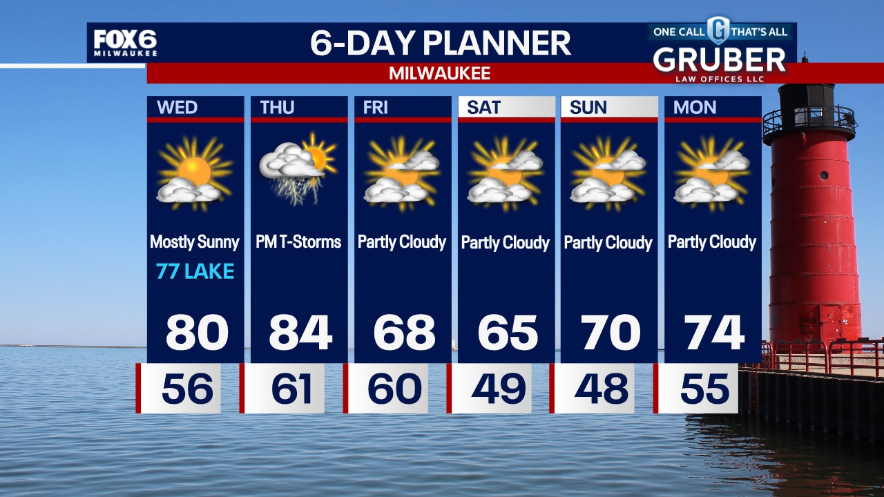
Clear skies overnight with temperatures dropping into the 50s. Mostly sunny on Wednesday with highs in the low 80s inland and upper 70s near the lake.
Clear skies overnight with temperatures dropping into the 50s. Mostly sunny on Wednesday with highs in the low 80s inland and upper 70s near the lake.
Weather Webcast with Chief Meteorologist Tom Wachs
Clear and quiet tonight with temperatures dropping through the 60s this evening and 50s overnight. More sun on the way Wednesday with highs in the upper 70s to around 80.
Clear and quiet tonight with temperatures dropping through the 60s this evening and 50s overnight. More sun on the way Wednesday with highs in the upper 70s to around 80.
Weather webcast with Lisa Michaels
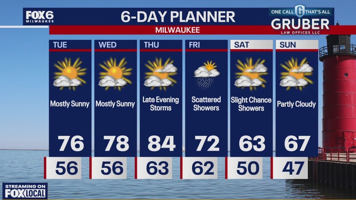
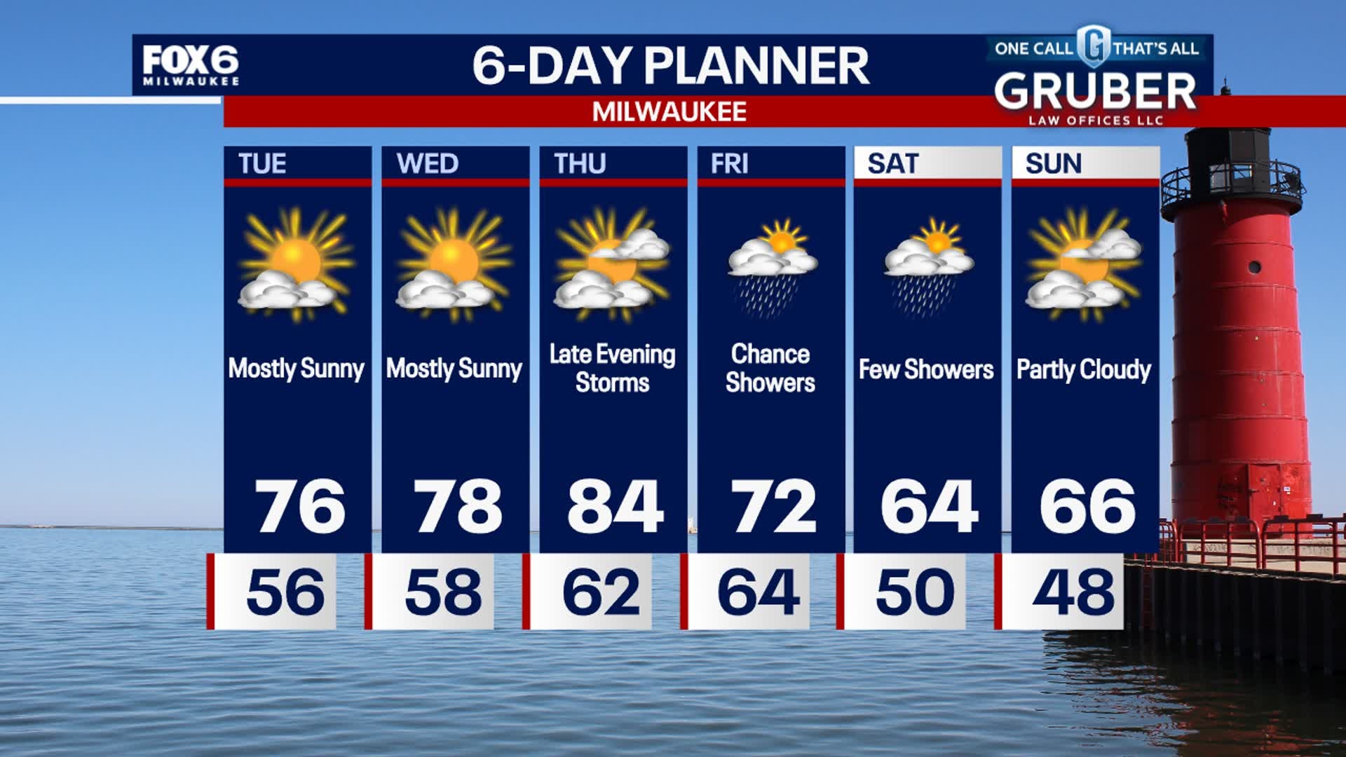
Sunny Tuesday with highs pushing into the mid to upper 70s. More sunshine and dry weather on Wednesday with high temps slowly warming into the upper 70s and maybe 80F inland. The warmest day of the week will be Thursday with 80s back and muggy conditions. A cold front will bring a few storms Thursday evening, then lingering, spotty showers Friday and Saturday. It'll be a much cooler weekend in the 60s.
Sunny Tuesday with highs pushing into the mid to upper 70s. More sunshine and dry weather on Wednesday with high temps slowly warming into the upper 70s and maybe 80F inland. The warmest day of the week will be Thursday with 80s back and muggy conditions. A cold front will bring a few storms Thursday evening, then lingering, spotty showers Friday and Saturday. It'll be a much cooler weekend in the 60s.
Weather Webcast with Stephanie Barichello
Clear and cool tonight with lows in the 40s and 50s, then great weather for back to school Tuesday! Highs in the middle 70s with sunshine. Rain returns Thursday evening and may linger at times into Friday and Saturday. Much cooler this weekend.
Clear and cool tonight with lows in the 40s and 50s, then great weather for back to school Tuesday! Highs in the middle 70s with sunshine. Rain returns Thursday evening and may linger at times into Friday and Saturday. Much cooler this weekend.
Weather webcast with Lisa Michaels
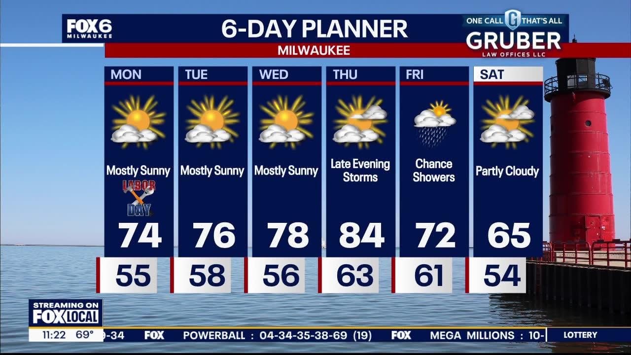
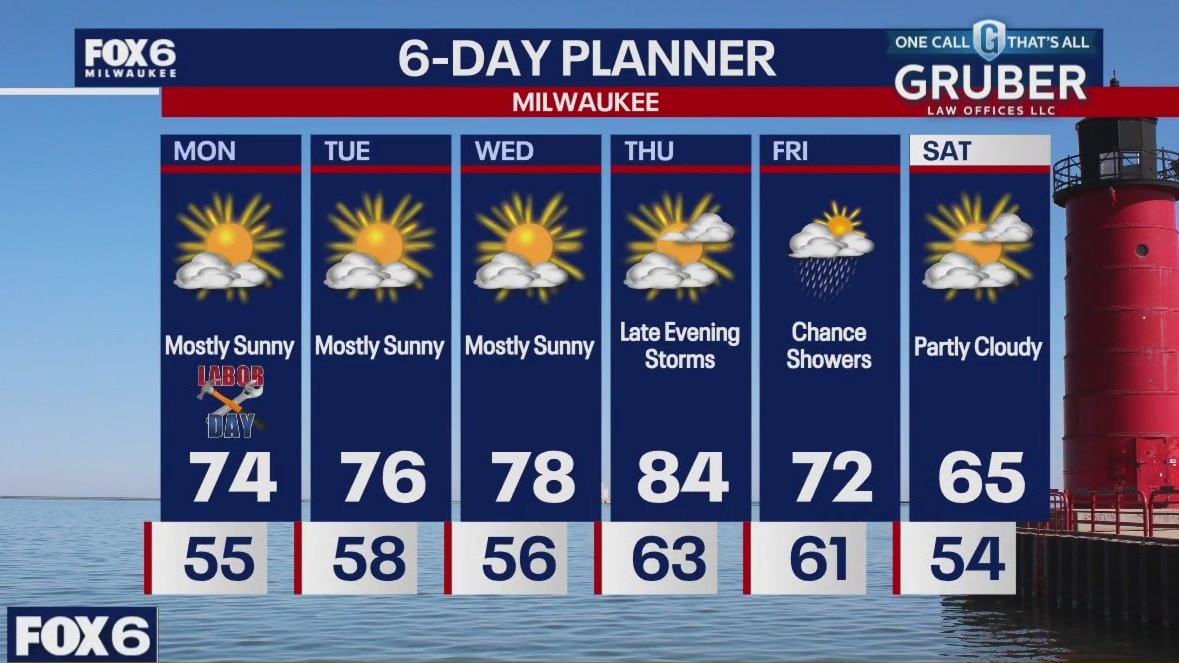
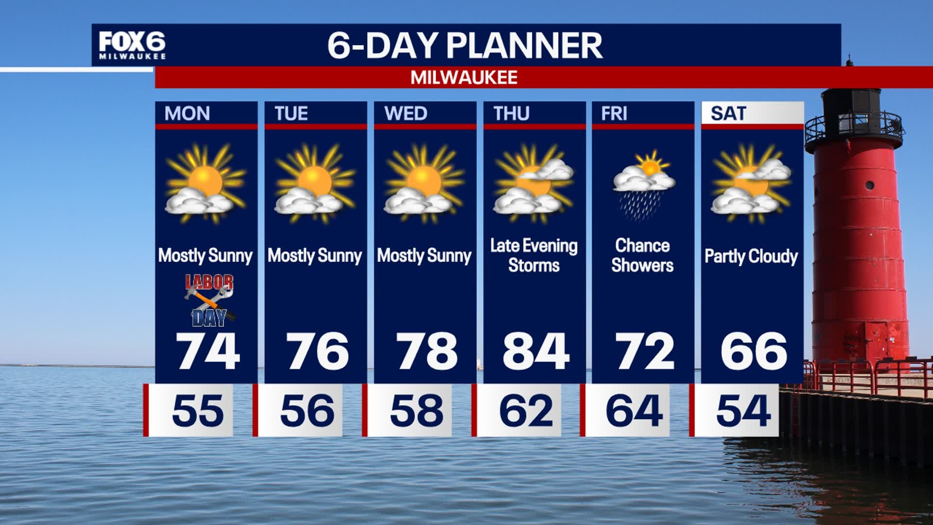
Sunshine and low 70s for Labor Day! Mid to upper 70s through midweek, then a brief warm up Thursday into the 80s. A cold front will bring a chance for showers and storms in the evening, then lingering showers throughout Friday. Cooler Saturday with highs in the 60s and evening temps in the 40s!
Sunshine and low 70s for Labor Day! Mid to upper 70s through midweek, then a brief warm up Thursday into the 80s. A cold front will bring a chance for showers and storms in the evening, then lingering showers throughout Friday. Cooler Saturday with highs in the 60s and evening temps in the 40s!
Weather webcast with Lisa Michaels
Sunshine and low 70s for Labor Day! Mid to upper 70s through midweek, then a brief warm up Thursday into the 80s. A cold front will bring a chance for showers and storms in the evening, then lingering showers throughout Friday. Cooler Saturday with highs in the 60s and evening temps in the 40s!
Sunshine and low 70s for Labor Day! Mid to upper 70s through midweek, then a brief warm up Thursday into the 80s. A cold front will bring a chance for showers and storms in the evening, then lingering showers throughout Friday. Cooler Saturday with highs in the 60s and evening temps in the 40s!
Weather Webcast with Stephanie Barichello
A cool night ahead with lows in the 40s and 50s, then sunny and comfortable again on Labor Day. Gradually warming the rest of the week, with the warmest being Thursday in the 80s. Much cooler weather next weekend behind a Friday cold front.
A cool night ahead with lows in the 40s and 50s, then sunny and comfortable again on Labor Day. Gradually warming the rest of the week, with the warmest being Thursday in the 80s. Much cooler weather next weekend behind a Friday cold front.