

Weather webcast with Lisa Michaels
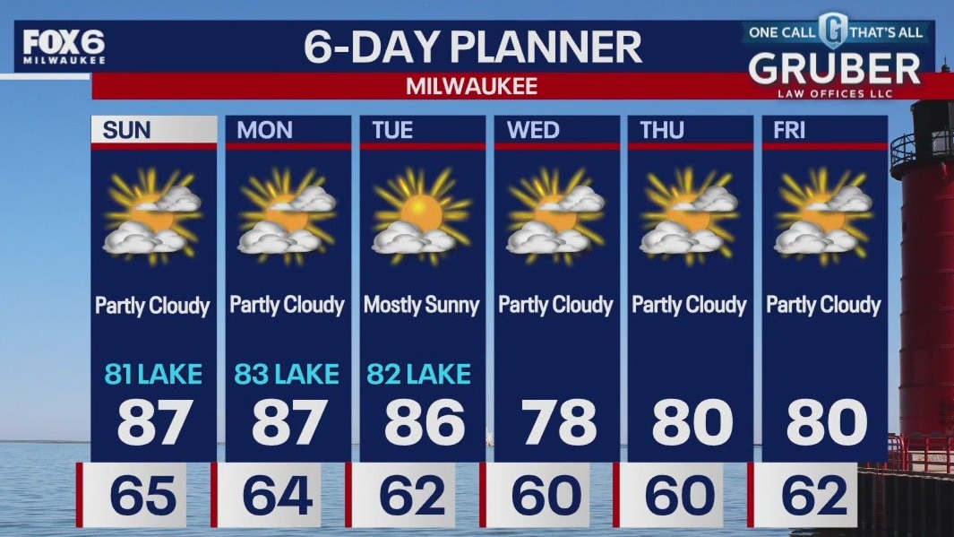
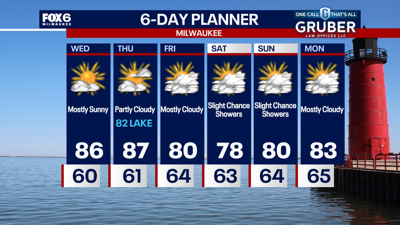
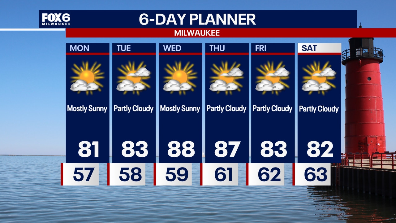
Partly sunny Sunday with warm temps in the low 80s near the lake to upper 80s inland. Humid. The warmer part of this week will be in the beginning with highs in the mid to upper 80s Monday & Tuesday.
Partly sunny Sunday with warm temps in the low 80s near the lake to upper 80s inland. Humid. The warmer part of this week will be in the beginning with highs in the mid to upper 80s Monday & Tuesday.
Weather Webcast with Chief Meteorologist Tom Wachs
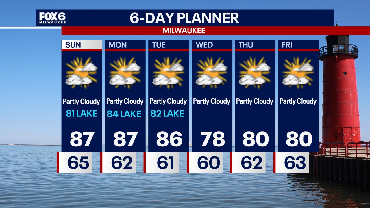
Patchy fog possible overnight with temperatures in the 60s. We have another warm and humid day on the way Sunday with highs in the upper 80s inland, lower 80s near the lake. Warm and dry for the week ahead.
Patchy fog possible overnight with temperatures in the 60s. We have another warm and humid day on the way Sunday with highs in the upper 80s inland, lower 80s near the lake. Warm and dry for the week ahead.

Weather Webcast with Chief Meteorologist Tom Wachs
Partly cloudy tonight with temperatures dropping into the 60s. Patchy fog is possible overnight with lows in the 60s. Partly sunny, warm and humid on Sunday with highs in the 80s, coolest near the lake.
Partly cloudy tonight with temperatures dropping into the 60s. Patchy fog is possible overnight with lows in the 60s. Partly sunny, warm and humid on Sunday with highs in the 80s, coolest near the lake.
Weather webcast with Lisa Michaels
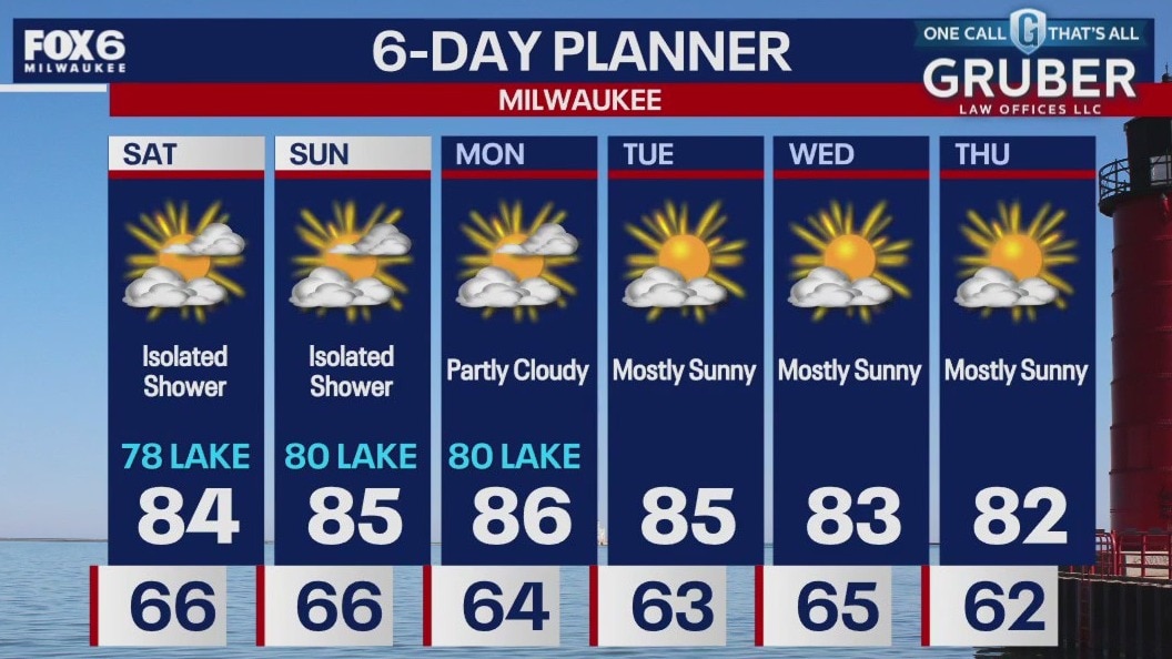
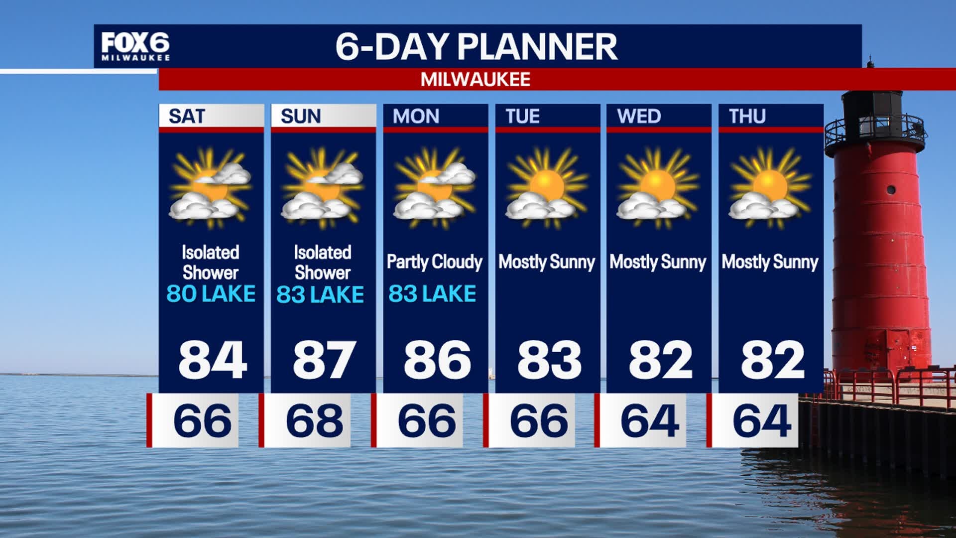
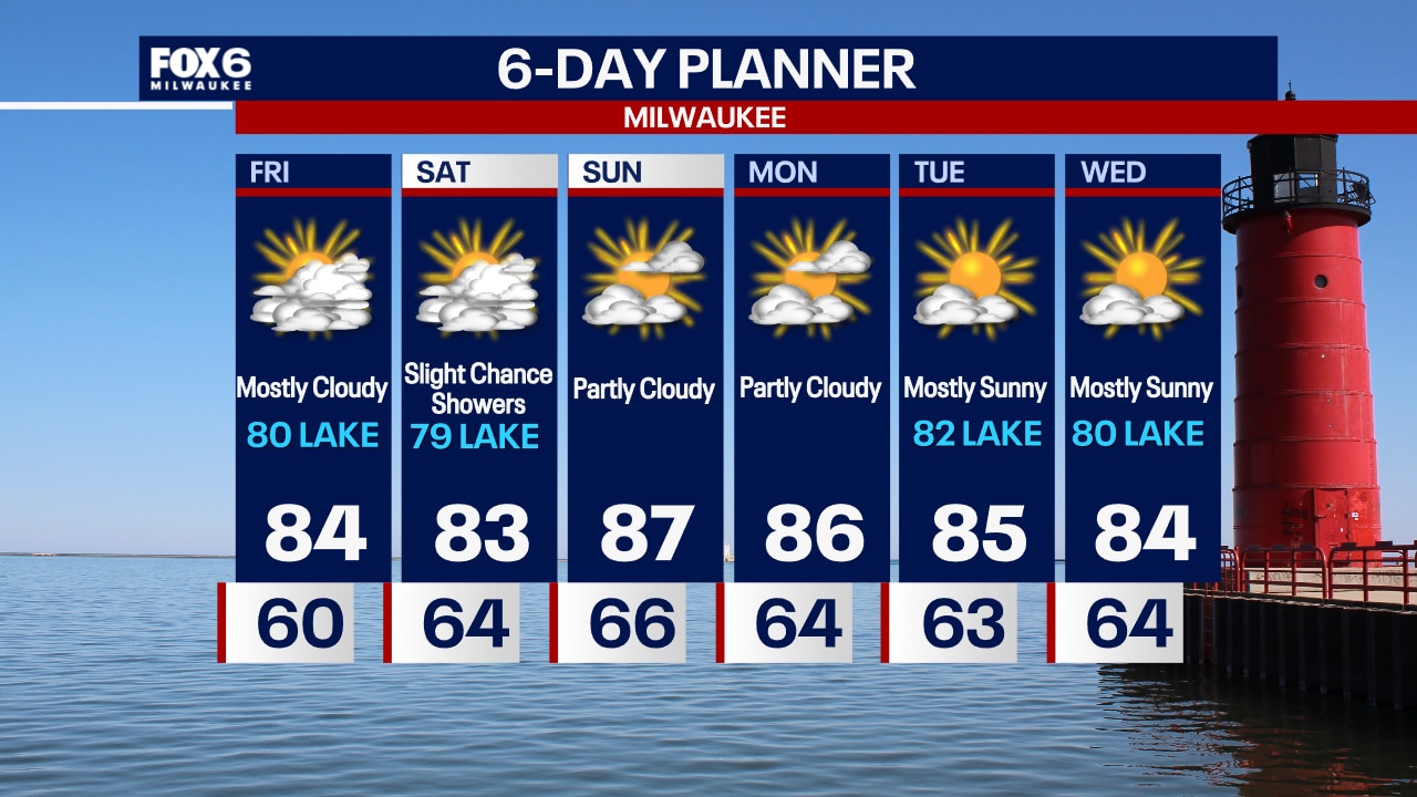
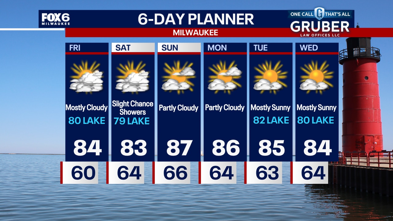
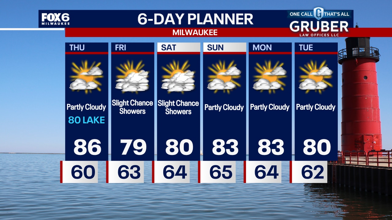
Partly to mostly cloudy Saturday with an isolated shower possible late in the day. Better chances inland. Temperatures above average in the mid 80s this weekend with muggy dew points in the low to mid 60s.
Partly to mostly cloudy Saturday with an isolated shower possible late in the day. Better chances inland. Temperatures above average in the mid 80s this weekend with muggy dew points in the low to mid 60s.
Weather Webcast with Stephanie Barichello
Warm weather continues this weekend with highs in the 80s, possibly even upper 80s on Sunday. There is a slight chance for a few passing showers Saturday and Sunday, but the chance is low. Sunshine continues through next week, along with above average temperatures.
Warm weather continues this weekend with highs in the 80s, possibly even upper 80s on Sunday. There is a slight chance for a few passing showers Saturday and Sunday, but the chance is low. Sunshine continues through next week, along with above average temperatures.

Weather webcast with Rob Haswell
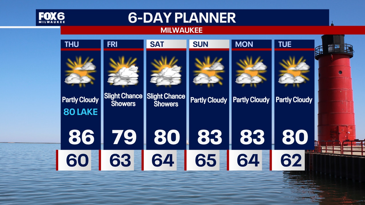
Hazy sunshine again today as wildfire smoke remains in the air. Air quality readings are in the moderate range for most locations. We will warm into the low to mid 80s again today with dew points in the low 60s. There is a slight chance for a few showers later in the day Saturday and into Sunday but otherwise, our dry stretch persists. We will be in the 80s well into next week. Average highs are in the mid 70s this time of year.
Hazy sunshine again today as wildfire smoke remains in the air. Air quality readings are in the moderate range for most locations. We will warm into the low to mid 80s again today with dew points in the low 60s. There is a slight chance for a few showers later in the day Saturday and into Sunday but otherwise, our dry stretch persists. We will be in the 80s well into next week. Average highs are in the mid 70s this time of year.
Weather Webcast with Chief Meteorologist Tom Wachs
Increasing clouds overnight with temperatures dropping through the 60s. Mostly cloudy and warm on Friday with highs in the 80s. Above average temperatures continue into next week.
Increasing clouds overnight with temperatures dropping through the 60s. Mostly cloudy and warm on Friday with highs in the 80s. Above average temperatures continue into next week.
Weather Webcast with Chief Meteorologist Tom Wachs
Increasing clouds tonight with the Northern Lights possible later tonight. Temperatures dropping into the 60s. Mostly cloudy and warm on Friday with highs in the 80s.
Increasing clouds tonight with the Northern Lights possible later tonight. Temperatures dropping into the 60s. Mostly cloudy and warm on Friday with highs in the 80s.
Weather webcast with Rob Haswell
High pressure continues to dominate our forecast for ample sunshine. However, wildfire smoke will persist for a hazy afternoon. High temperatures will reach the mid to upper 80s today and dew points will creep into the low 60s. We stay warm and dry for Friday and Saturday but rain finally returns to the forecast by Sunday. Warmer than average conditions will remain well into next week.
High pressure continues to dominate our forecast for ample sunshine. However, wildfire smoke will persist for a hazy afternoon. High temperatures will reach the mid to upper 80s today and dew points will creep into the low 60s. We stay warm and dry for Friday and Saturday but rain finally returns to the forecast by Sunday. Warmer than average conditions will remain well into next week.
Weather Webcast with Chief Meteorologist Tom Wachs
Clear skies overnight with temperatures in the upper 50s to low 60s. Increasing clouds on Thursday ahead of the remnants of Hurricane Francine. Highs in the low-to-mid 80s.
Clear skies overnight with temperatures in the upper 50s to low 60s. Increasing clouds on Thursday ahead of the remnants of Hurricane Francine. Highs in the low-to-mid 80s.
Weather Webcast with Chief Meteorologist Tom Wachs
Clear skies continue tonight with temperatures dropping into the 60s. Partly sunny on Thursday with highs in the 80s.
Clear skies continue tonight with temperatures dropping into the 60s. Partly sunny on Thursday with highs in the 80s.
Weather webcast with Lisa Michaels
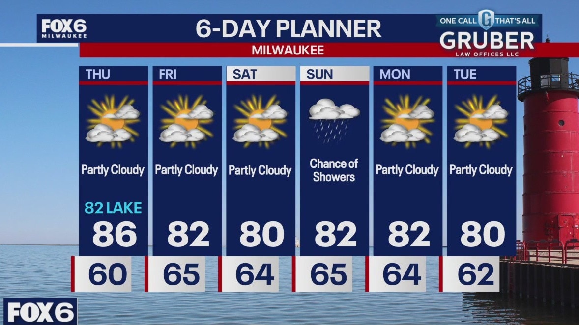
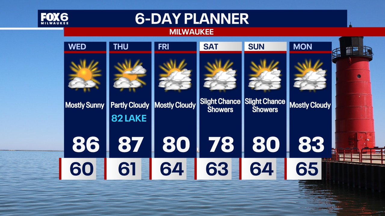
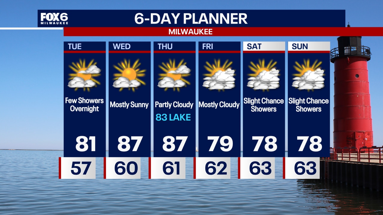
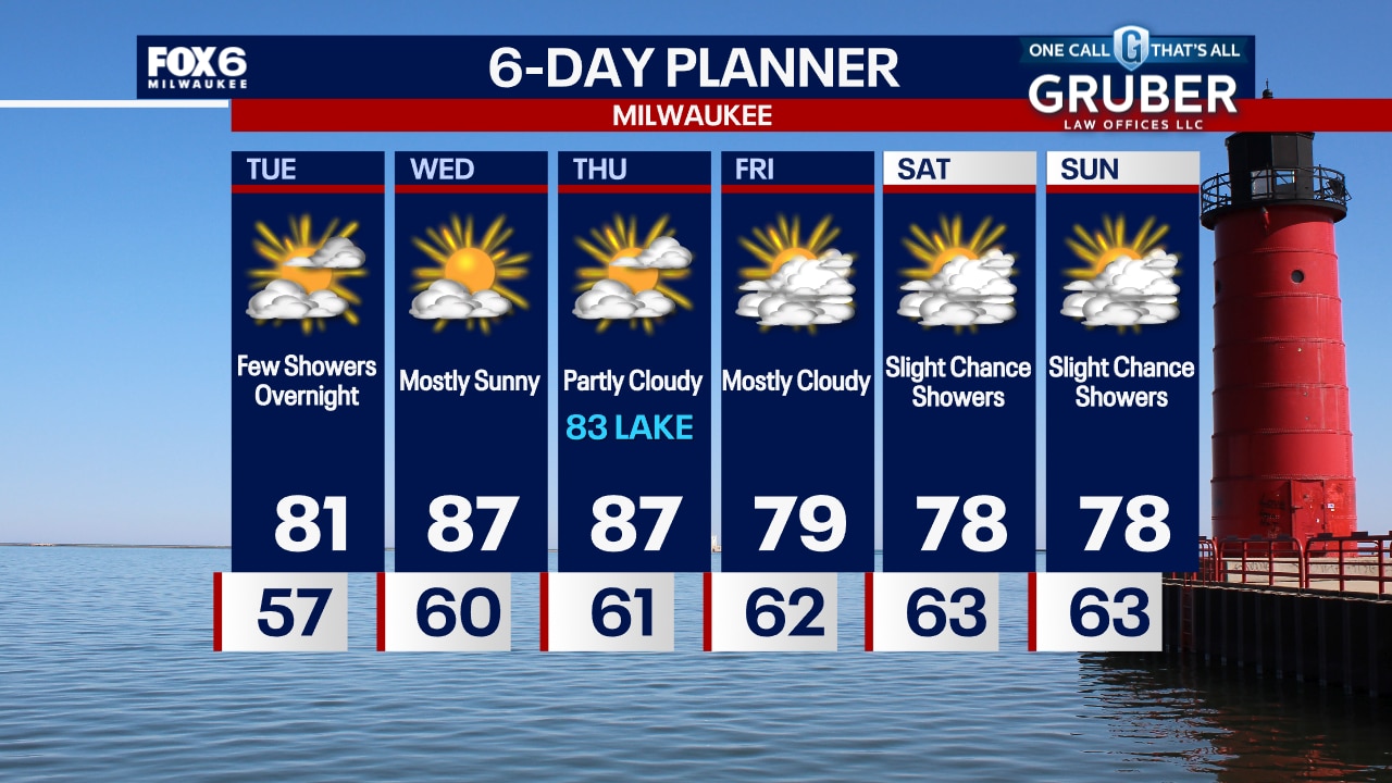
Another hazy day with sunshine and a few cloudy periods. Hotter today with highs in the upper 80s but turning cooler late day lakeside on a SE wind. Staying warmer overnight as well with low to mid 60s for the next few nights. We stay warm and dry Thursday and Friday but we should get a few showers going by late Saturday into Sunday. Temperatures remain above the mid 70s climate averages for the next several days.
Another hazy day with sunshine and a few cloudy periods. Hotter today with highs in the upper 80s but turning cooler late day lakeside on a SE wind. Staying warmer overnight as well with low to mid 60s for the next few nights. We stay warm and dry Thursday and Friday but we should get a few showers going by late Saturday into Sunday. Temperatures remain above the mid 70s climate averages for the next several days.
Weather webcast with Rob Haswell
Another hazy day with sunshine and a few cloudy periods. Hotter today with highs in the upper 80s but turning cooler late day lakeside on a SE wind. Staying warmer overnight as well with low to mid 60s for the next few nights. We stay warm and dry Thursday and Friday but we should get a few showers going by late Saturday into Sunday. Temperatures remain above the mid 70s climate averages for the next several days.
Another hazy day with sunshine and a few cloudy periods. Hotter today with highs in the upper 80s but turning cooler late day lakeside on a SE wind. Staying warmer overnight as well with low to mid 60s for the next few nights. We stay warm and dry Thursday and Friday but we should get a few showers going by late Saturday into Sunday. Temperatures remain above the mid 70s climate averages for the next several days.
Weather Webcast with Chief Meteorologist Tom Wachs
Partly to mostly cloudy overnight with temperatures in the upper 50s to low 60s. There is a slight chance for a rain shower overnight into Wednesday morning. Becoming mostly sunny, breezy and warm. Highs in the mid-80s.
Partly to mostly cloudy overnight with temperatures in the upper 50s to low 60s. There is a slight chance for a rain shower overnight into Wednesday morning. Becoming mostly sunny, breezy and warm. Highs in the mid-80s.
Weather Webcast with Chief Meteorologist Tom Wachs
Wildfire smoke possible in our skies for the next few days, otherwise only a slight chance for a rain shower tonight and Wednesday morning. Mostly sunny and warm on Wednesday with highs in the mid-80s.
Wildfire smoke possible in our skies for the next few days, otherwise only a slight chance for a rain shower tonight and Wednesday morning. Mostly sunny and warm on Wednesday with highs in the mid-80s.
Weather webcast with Rob Haswell
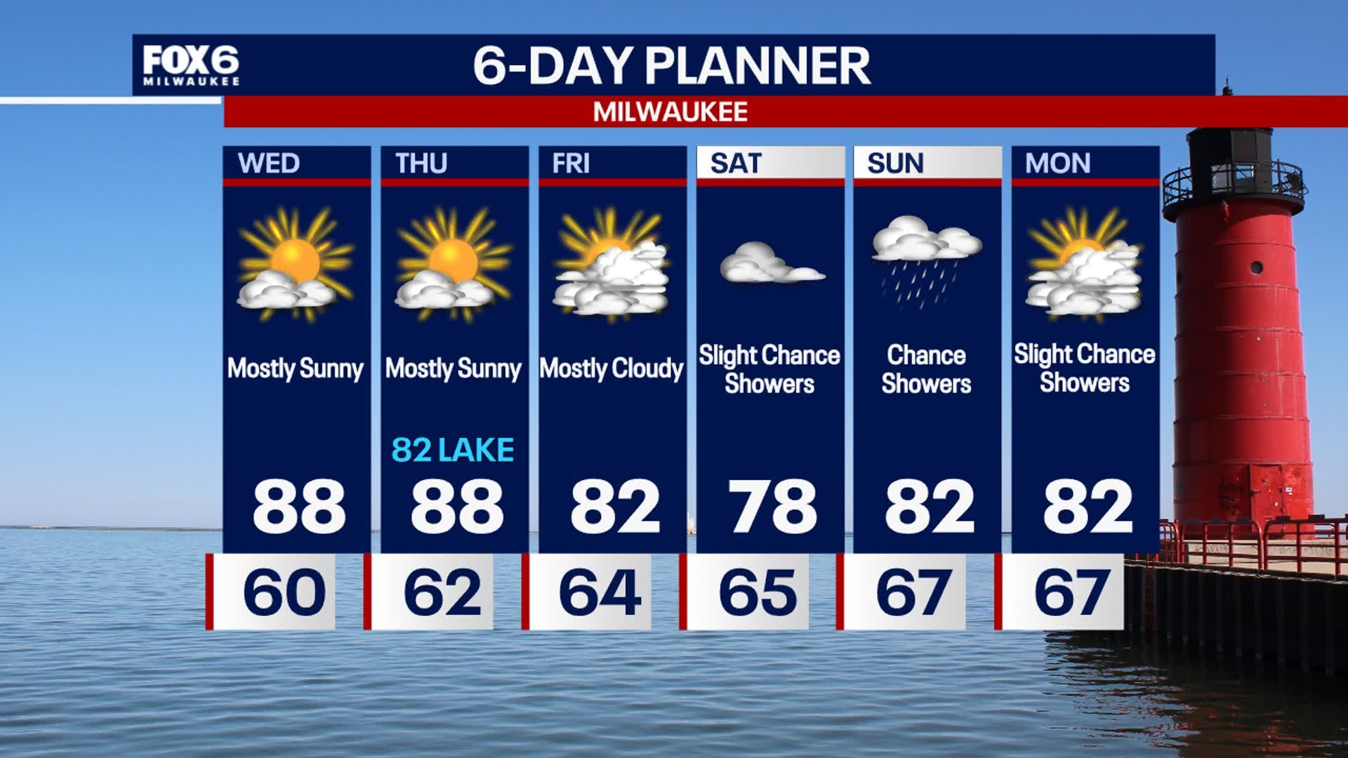
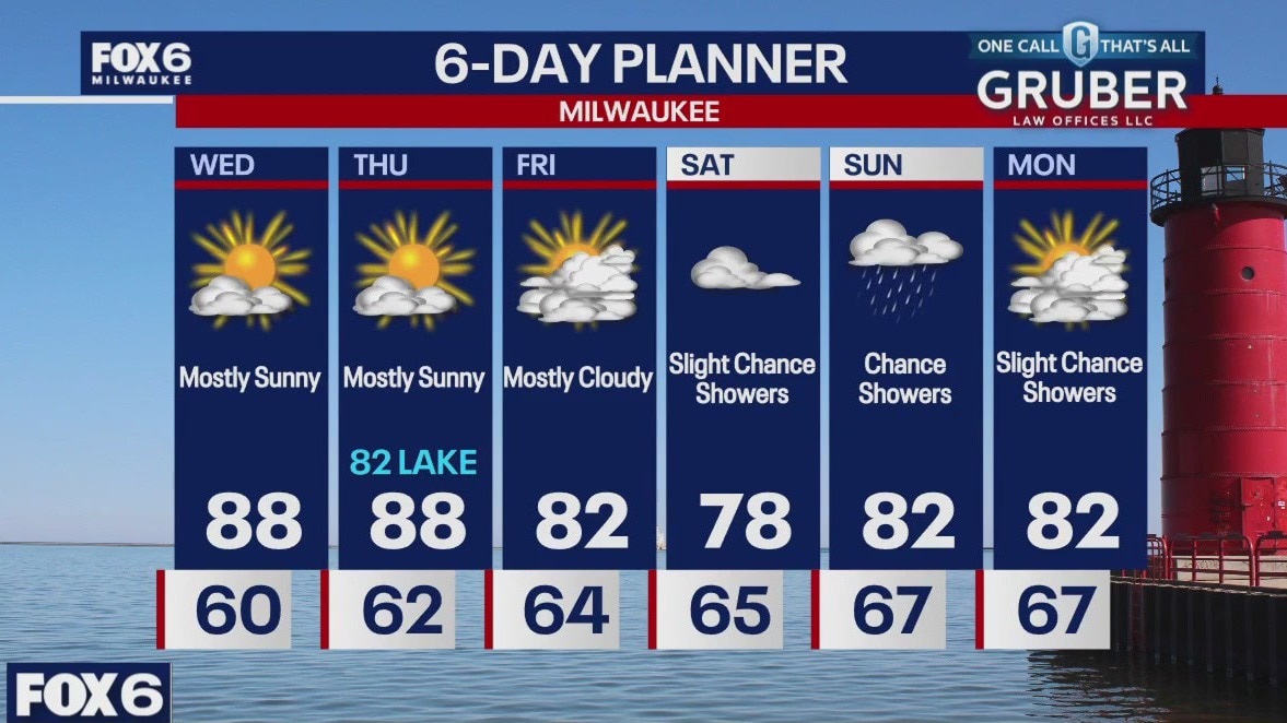
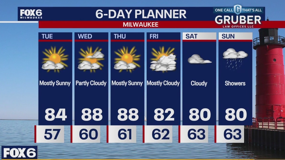
We continue to see warmer air moving into our area today with highs reaching the low to mid 80s. We will continue to warm into the upper 80s Wednesday and Thursday and only cool slightly after that. A dry forecast persists with only a very slight chance of rain early Wednesday and into Saturday afternoon. The most likely chance of rain waits until Saturday night into Sunday.
We continue to see warmer air moving into our area today with highs reaching the low to mid 80s. We will continue to warm into the upper 80s Wednesday and Thursday and only cool slightly after that. A dry forecast persists with only a very slight chance of rain early Wednesday and into Saturday afternoon. The most likely chance of rain waits until Saturday night into Sunday.
Weather Webcast with Chief Meteorologist Tom Wachs
Clear skies overnight with temperatures in the 50s by sunrise. Mostly sunny, breezy and warm again on Tuesday with highs in the low 80s.
Clear skies overnight with temperatures in the 50s by sunrise. Mostly sunny, breezy and warm again on Tuesday with highs in the low 80s.
Weather Webcast with Chief Meteorologist Tom Wachs
Clear skies tonight with temperatures dropping through the 60s. Partly sunny, breezy and warm again on Tuesday. Highs in the low 80s. A few rain showers are possible late Tuesday night.
Clear skies tonight with temperatures dropping through the 60s. Partly sunny, breezy and warm again on Tuesday. Highs in the low 80s. A few rain showers are possible late Tuesday night.

Weather webcast with Rob Haswell
High pressure continues to dominate our forecast for mostly sunny and dry conditions this week. A wildfire to our NW could also send us a bit of smoke today for a hazy sunshine at times. We stay dry for the next several days. Our next chance of rain isn't until later in the day on Saturday and even then is only slight.
High pressure continues to dominate our forecast for mostly sunny and dry conditions this week. A wildfire to our NW could also send us a bit of smoke today for a hazy sunshine at times. We stay dry for the next several days. Our next chance of rain isn't until later in the day on Saturday and even then is only slight.
Weather Webcast with Chief Meteorologist Tom Wachs
Clear and breezy overnight with temperatures in the 50s by sunrise. Mostly sunny, breezy and warmer on Monday with highs in the low 80s.
Clear and breezy overnight with temperatures in the 50s by sunrise. Mostly sunny, breezy and warmer on Monday with highs in the low 80s.