

Weather Webcast with Chief Meteorologist Tom Wachs
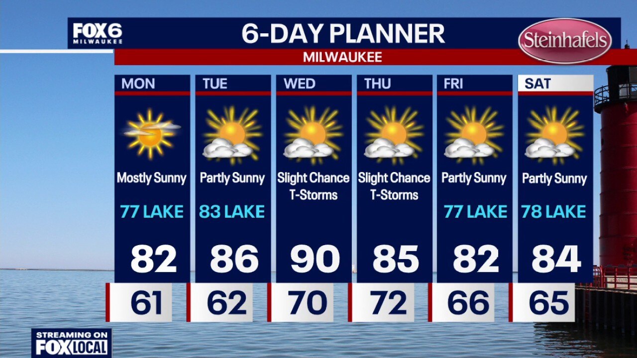
Clear skies overnight with temperatures dropping into the upper 50s to low 60s and dew points dropping into the 50s. Mostly sunny on Monday with highs in the low 80s inland, upper 70s near the lake. Dew points in the upper 50s. Quiet again on Tuesday with partly sunny skies and highs in the low-to-mid 80s.
Clear skies overnight with temperatures dropping into the upper 50s to low 60s and dew points dropping into the 50s. Mostly sunny on Monday with highs in the low 80s inland, upper 70s near the lake. Dew points in the upper 50s. Quiet again on Tuesday with partly sunny skies and highs in the low-to-mid 80s.
Weather Webcast with Chief Meteorologist Tom Wachs
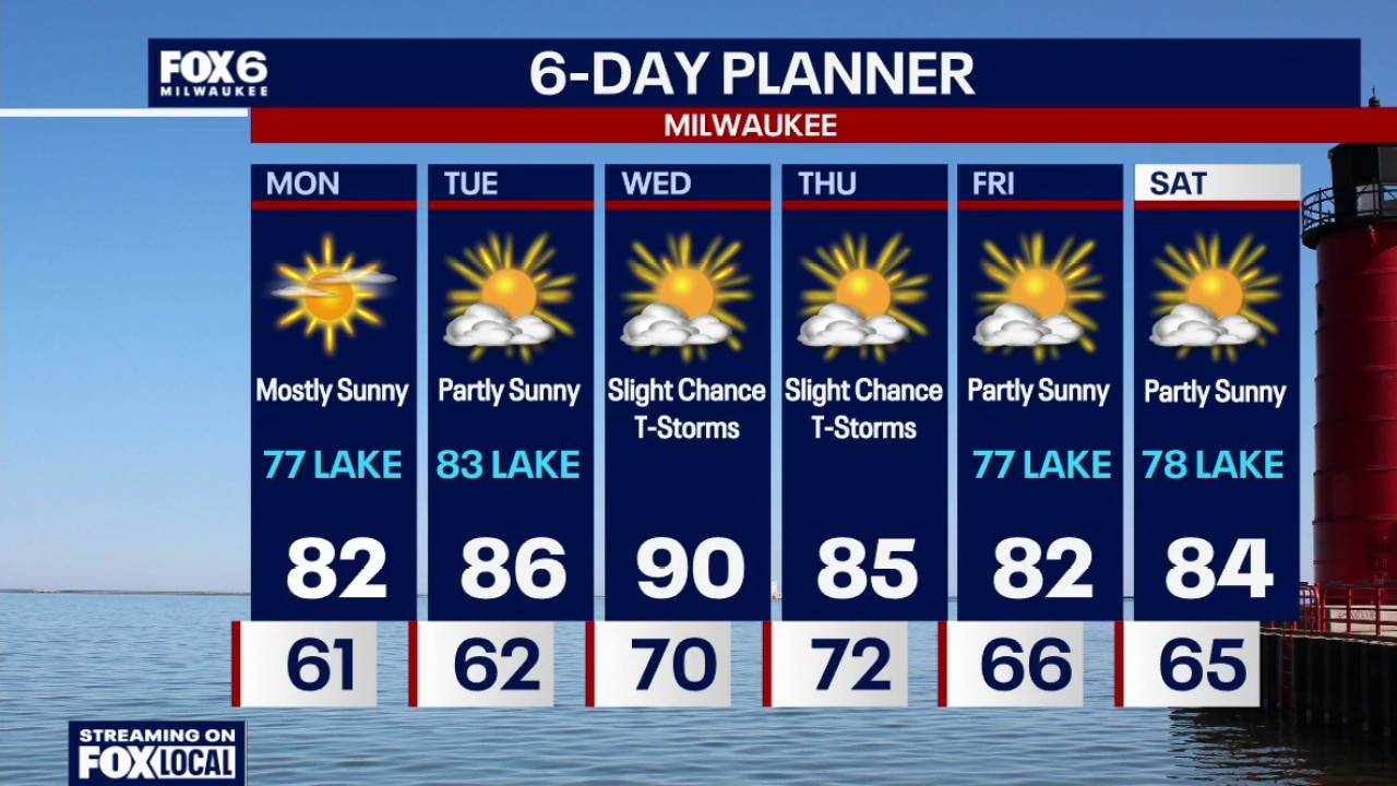
Clearing skies tonight with temperatures dropping into the 60s and dew points dropping into the 50s. Mostly sunny on Monday with highs in the low 80s inland, upper 70s near the lake. Dew points in the upper 50s. Quiet again on Tuesday with partly sunny skies and highs in the low-to-mid 80s.
Clearing skies tonight with temperatures dropping into the 60s and dew points dropping into the 50s. Mostly sunny on Monday with highs in the low 80s inland, upper 70s near the lake. Dew points in the upper 50s. Quiet again on Tuesday with partly sunny skies and highs in the low-to-mid 80s.
Weather Webcast with Chief Meteorologist Rob Haswell
Southern Wisconsin is in for another fairly quiet summer day with just a few isolated showers or thunderstorms possible. Any storms that do pop up will be few and far between. The bigger story is the return of more comfortable air as humidity continues to ease through the first half of the week.
Southern Wisconsin is in for another fairly quiet summer day with just a few isolated showers or thunderstorms possible. Any storms that do pop up will be few and far between. The bigger story is the return of more comfortable air as humidity continues to ease through the first half of the week.
July 4th weather webcast with Lisa Michaels
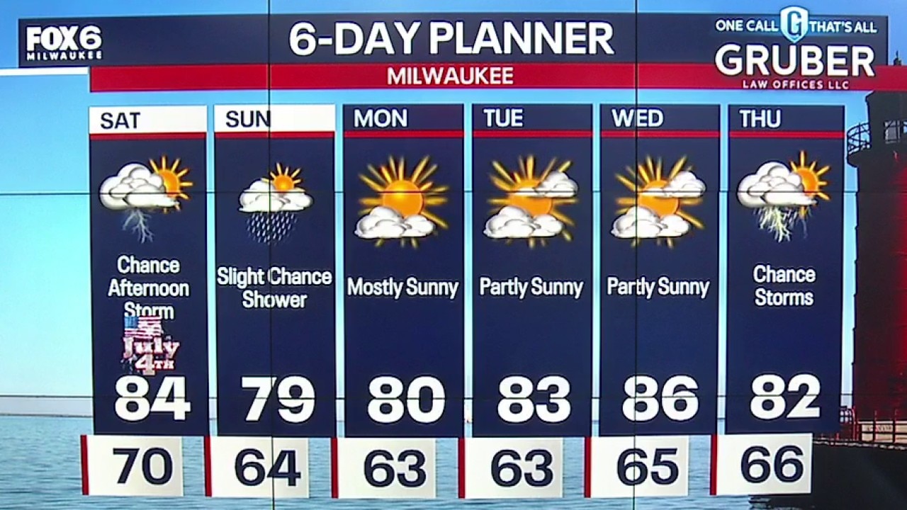
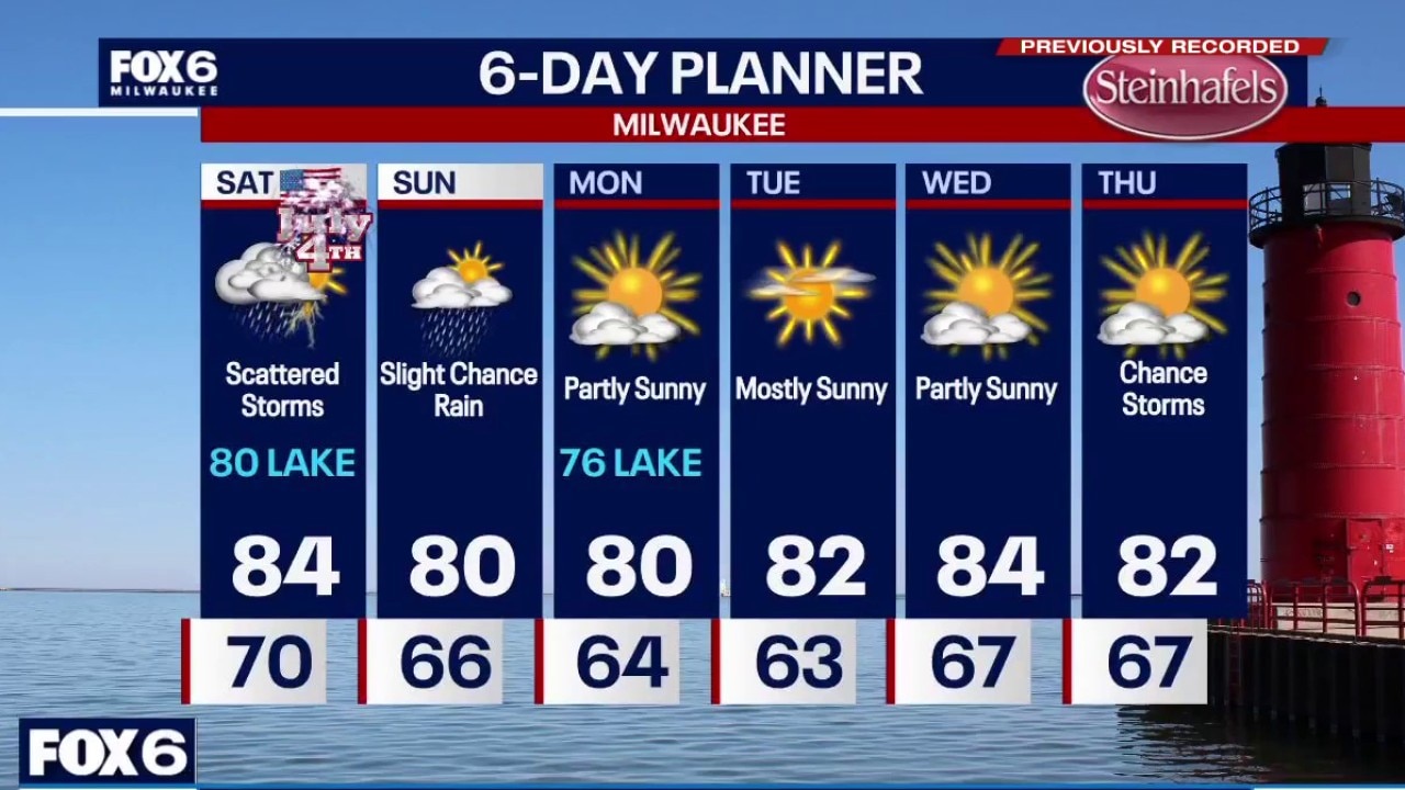
Partly to mostly cloudy on the 4th of July. There is a chance for a few afternoon storms that can produce gusty winds and lightning. Highs in the mid 80s inland to near 80F by the lake and humid. Cooler on Sunday in the upper 70.
Partly to mostly cloudy on the 4th of July. There is a chance for a few afternoon storms that can produce gusty winds and lightning. Highs in the mid 80s inland to near 80F by the lake and humid. Cooler on Sunday in the upper 70.
Webcast Weather with Holly Baker
We are tracking a chance for scattered storms with opportunity for dry time.
We are tracking a chance for scattered storms with opportunity for dry time.
Weather webcast with Meteorologist Stephanie Barichello
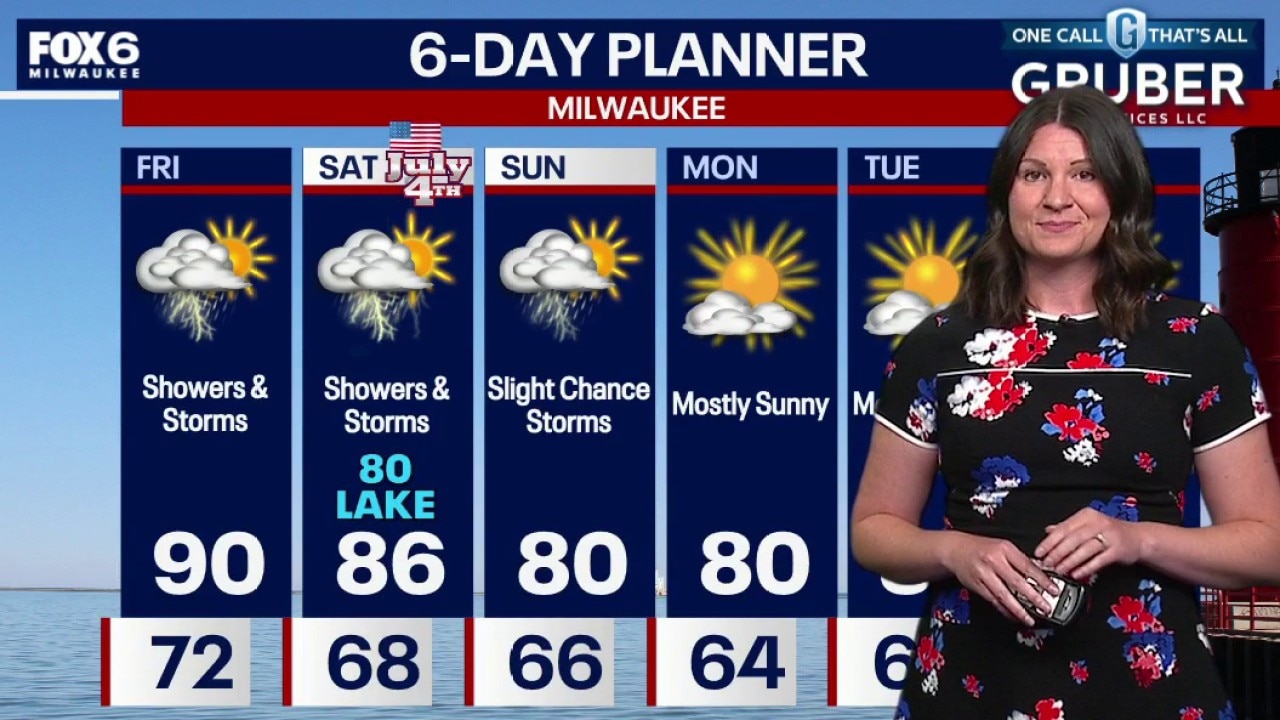
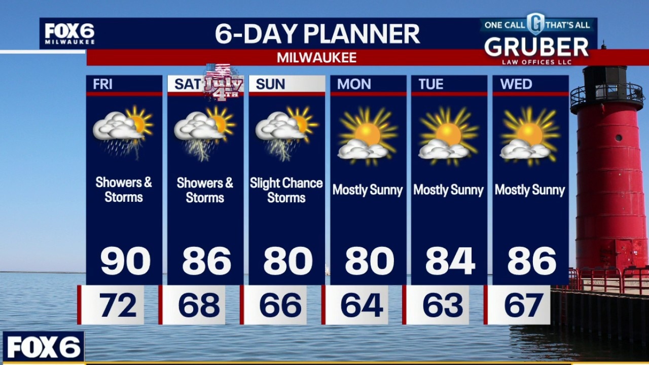
Southern Wisconsin isn't done with the stormy pattern just yet, but Friday's forecast hinges on what happens during the morning hours. If enough sunshine breaks through after the early showers, scattered thunderstorms could redevelop Friday afternoon, with a few producing gusty winds and hail.
Southern Wisconsin isn't done with the stormy pattern just yet, but Friday's forecast hinges on what happens during the morning hours. If enough sunshine breaks through after the early showers, scattered thunderstorms could redevelop Friday afternoon, with a few producing gusty winds and hail.
Weather webcast with Rob Haswell
Southern Wisconsin isn't done with the stormy pattern just yet, but Friday's forecast hinges on what happens during the morning hours.
Southern Wisconsin isn't done with the stormy pattern just yet, but Friday's forecast hinges on what happens during the morning hours.
Weather webcast with Stephanie Barichello
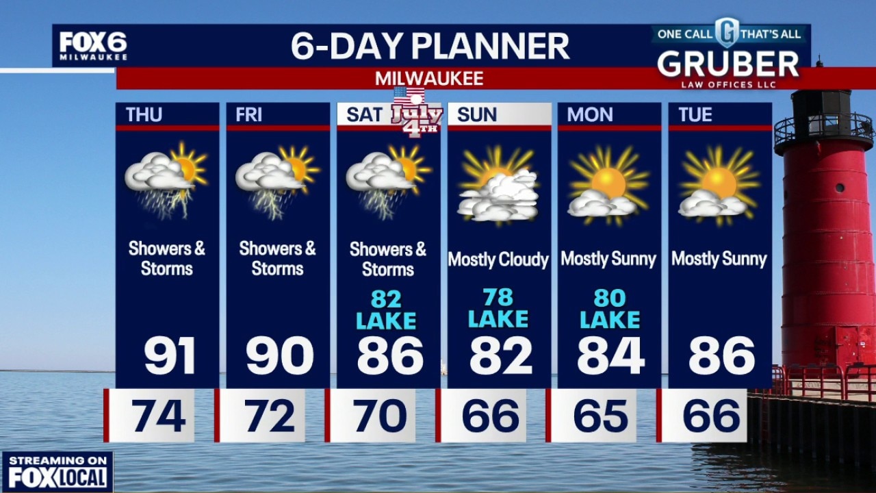
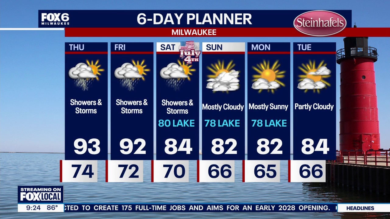
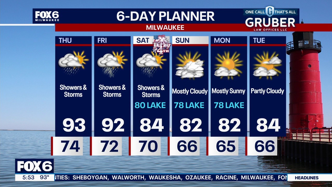
Additional storms are expected Thursday afternoon and evening. Stronger storms could develop if enough sunshine returns after the morning activity. The Fourth of July holiday weekend continues to look unsettled.
Additional storms are expected Thursday afternoon and evening. Stronger storms could develop if enough sunshine returns after the morning activity. The Fourth of July holiday weekend continues to look unsettled.
Weather webcast with Rob Haswell
Southern Wisconsin remains under an Extreme Heat Warning through Thursday at 1 p.m. Thunderstorms move through the region in the early morning with damaging winds and heavy rainfall as the primary threats.
Southern Wisconsin remains under an Extreme Heat Warning through Thursday at 1 p.m. Thunderstorms move through the region in the early morning with damaging winds and heavy rainfall as the primary threats.
Weather Webcast with Stephanie Barichello
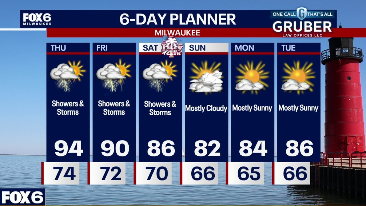
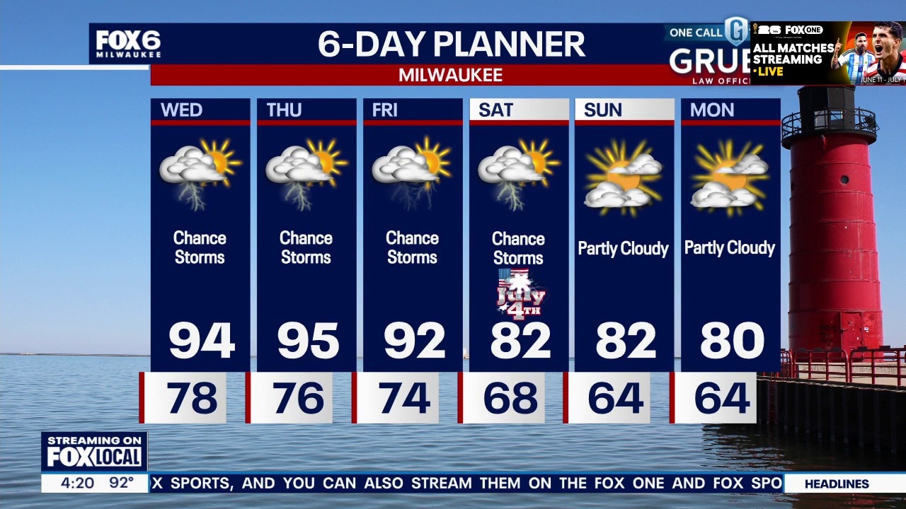
More heat and humidity Thursday, along with a chance of storms overnight through Thursday morning. Scattered thunderstorms become more likely Thursday through Saturday, and may impact holiday plans. The heat breaks over the weekend but humidity remains high.
More heat and humidity Thursday, along with a chance of storms overnight through Thursday morning. Scattered thunderstorms become more likely Thursday through Saturday, and may impact holiday plans. The heat breaks over the weekend but humidity remains high.
Weather Webcast with Stephanie Barichello
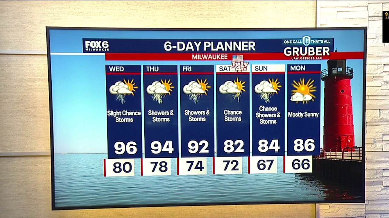
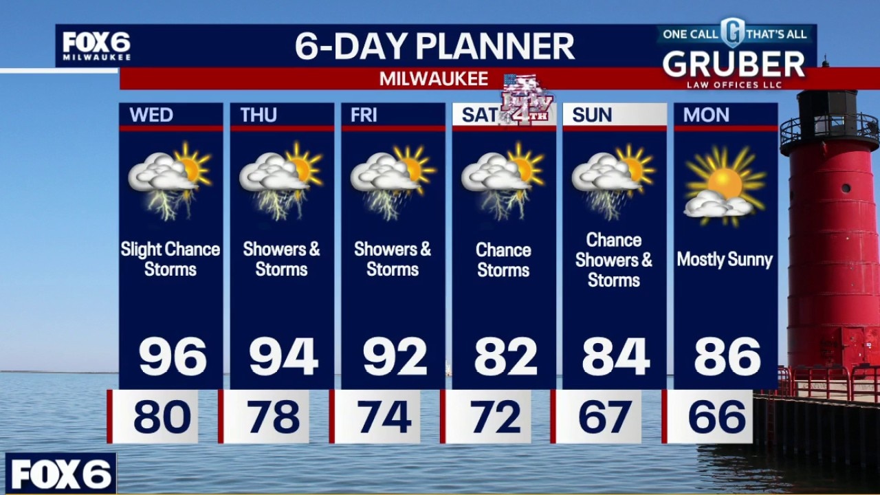
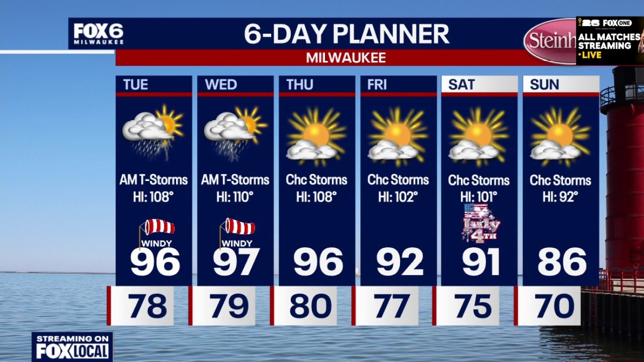
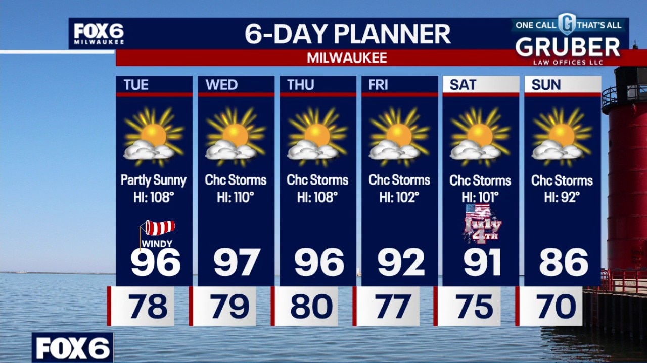
Extreme Heat Warning continues through 10pm Thursday. Thunderstorms are possible tonight, and then scattered through Saturday as the ridge of high pressure begins to break down. That also means slightly cooler temperatures over the weekend, although high humidity remains. For now, two more days of heat indices in the 100s.
Extreme Heat Warning continues through 10pm Thursday. Thunderstorms are possible tonight, and then scattered through Saturday as the ridge of high pressure begins to break down. That also means slightly cooler temperatures over the weekend, although high humidity remains. For now, two more days of heat indices in the 100s.
Weather webcast with Lisa Michaels
Extreme heat warning in effect through 7pm Wednesday. The dangerous heat continues through today, but the forecast is becoming increasingly focused on multiple rounds of thunderstorms through the holiday weekend.
Extreme heat warning in effect through 7pm Wednesday. The dangerous heat continues through today, but the forecast is becoming increasingly focused on multiple rounds of thunderstorms through the holiday weekend.
Weather webcast with Rob Haswell
Partly cloudy, warm and humid overnight. Temperatures around 80 by sunrise. Scattered t-Storms are possible on Wednesday and Wednesday night. Partly sunny, windy, hot and humid. Highs in the mid-90s with a heat index around 107.
Partly cloudy, warm and humid overnight. Temperatures around 80 by sunrise. Scattered t-Storms are possible on Wednesday and Wednesday night. Partly sunny, windy, hot and humid. Highs in the mid-90s with a heat index around 107.
Weather Webcast with Chief Meteorologist Tom Wachs
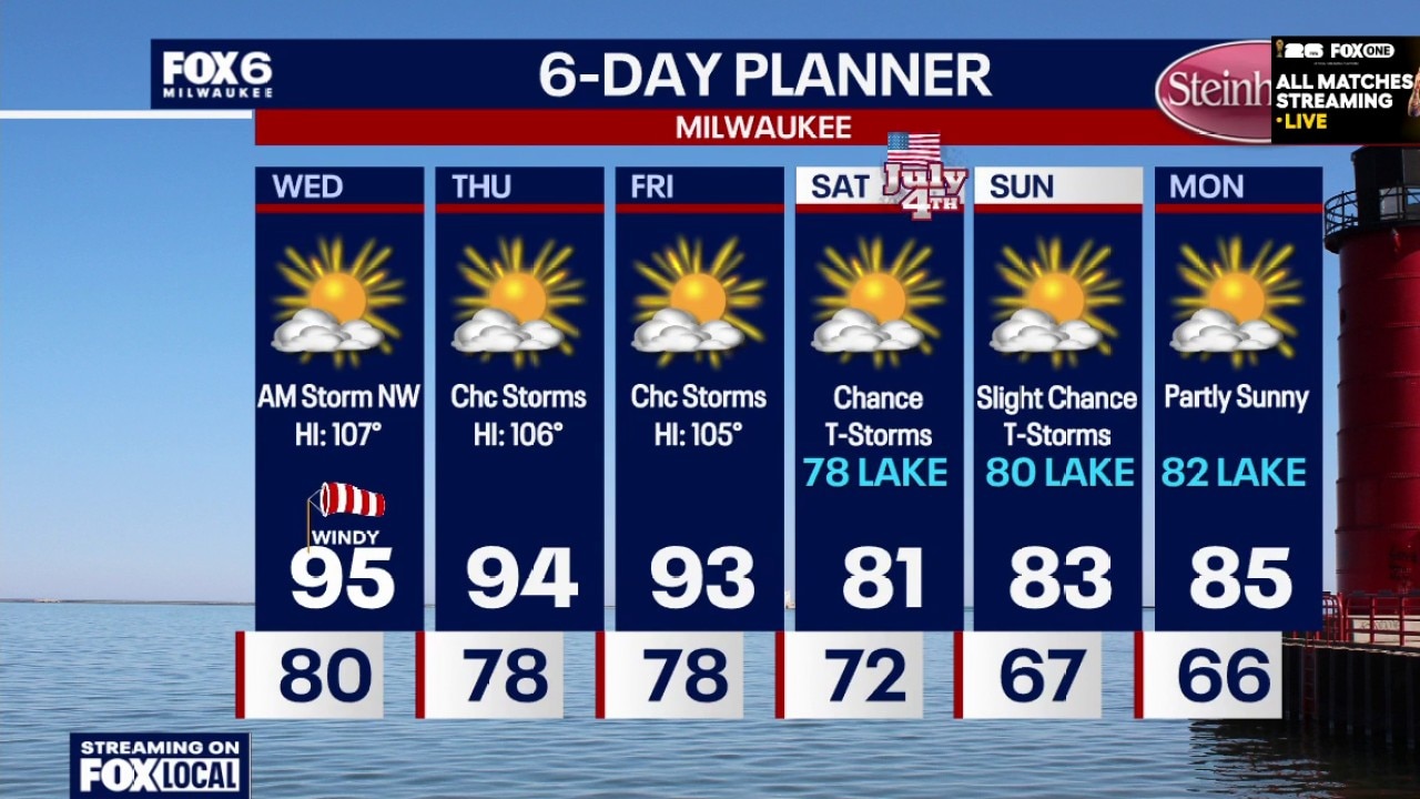
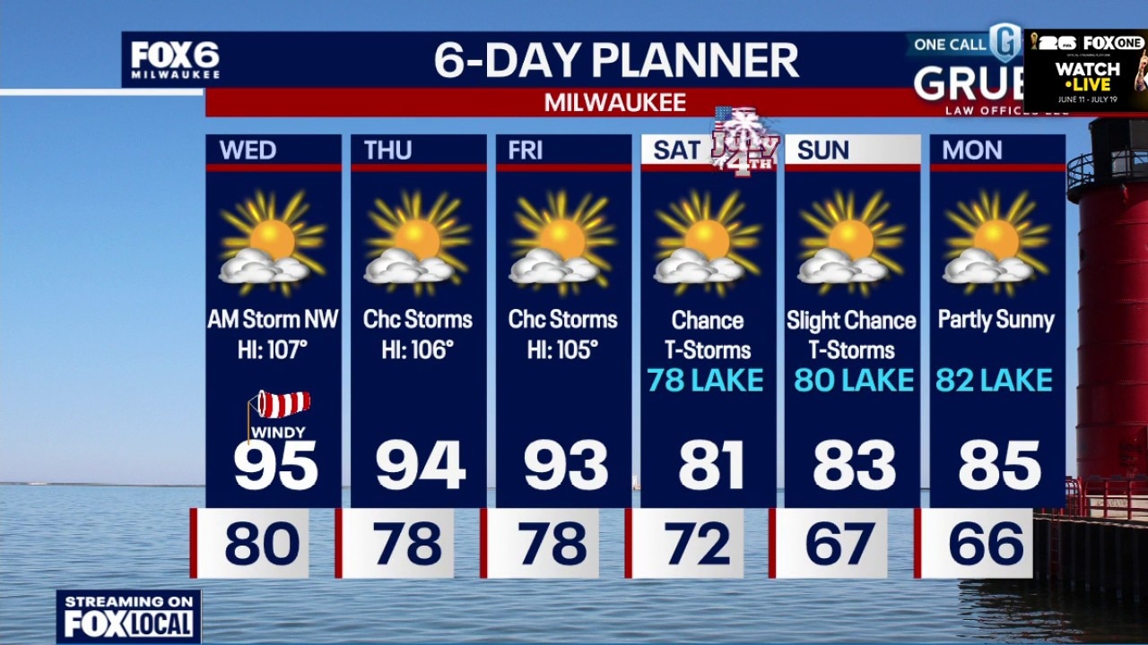
Extreme Heat Warning for ALL OF SE WI until 7pm Wednesday. Partly cloudy, warm and humid overnight. Temperatures around 80 by sunrise. Scattered t-Storms are possible on Wednesday and Wednesday night. Partly sunny, windy, hot and humid. Highs in the mid-90s with a heat index around 107.
Extreme Heat Warning for ALL OF SE WI until 7pm Wednesday. Partly cloudy, warm and humid overnight. Temperatures around 80 by sunrise. Scattered t-Storms are possible on Wednesday and Wednesday night. Partly sunny, windy, hot and humid. Highs in the mid-90s with a heat index around 107.
Weather Webcast with Chief Meteorologist Tom Wachs
Partly cloudy, warm and humid tonight. Temperatures in the 80s this evening and around 80 overnight. T-Storms are possible well NW of Milwaukee on Wednesday AM. Partly sunny, windy, hot and humid. Highs in the mid-90s with a heat index around 107.
Partly cloudy, warm and humid tonight. Temperatures in the 80s this evening and around 80 overnight. T-Storms are possible well NW of Milwaukee on Wednesday AM. Partly sunny, windy, hot and humid. Highs in the mid-90s with a heat index around 107.
Weather Webcast with Stephanie Barichello
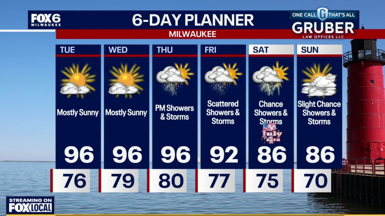
An extreme heat warning continues through 7pm on Wednesday. Plan on heat index values in the 100s for a few more days. There is a chance of morning storms in northern counties Wednesday, then scattered storms possible Thursday through Saturday. Heat looks to break by the weekend as a lake breeze returns! It will remain humid, though.
An extreme heat warning continues through 7pm on Wednesday. Plan on heat index values in the 100s for a few more days. There is a chance of morning storms in northern counties Wednesday, then scattered storms possible Thursday through Saturday. Heat looks to break by the weekend as a lake breeze returns! It will remain humid, though.
Weather webcast with Stephanie Barichello
The dangerous heat isn't going anywhere just yet, with the Extreme Heat Warning continuing through Wednesday across southern Wisconsin.
The dangerous heat isn't going anywhere just yet, with the Extreme Heat Warning continuing through Wednesday across southern Wisconsin.
Weather webcast with Rob Haswell
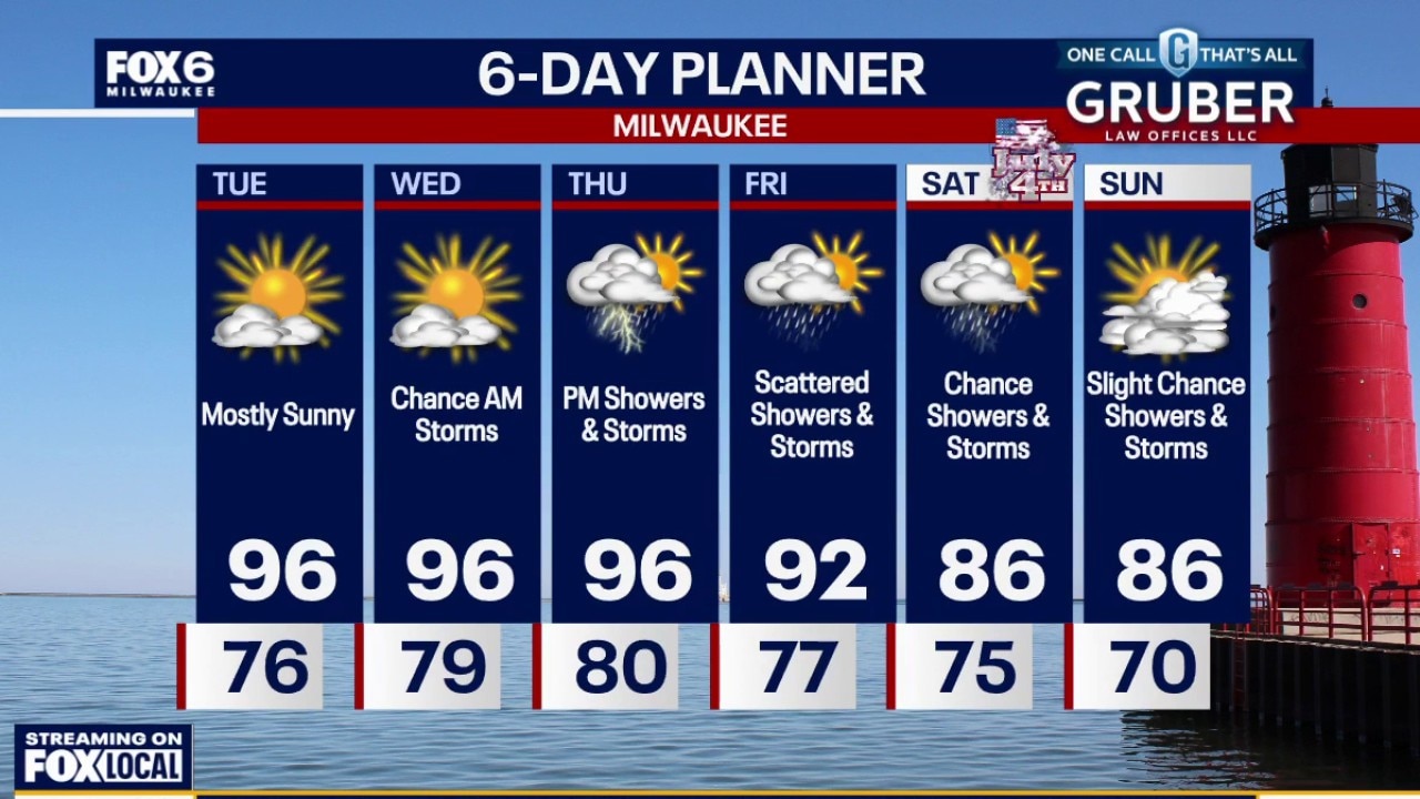
The dangerous heat isn't going anywhere just yet, with the Extreme Heat Warning continuing through Wednesday across southern Wisconsin. Tuesday looks mainly dry, but the combination of heat and humidity will once again push heat index values into dangerous territory.
The dangerous heat isn't going anywhere just yet, with the Extreme Heat Warning continuing through Wednesday across southern Wisconsin. Tuesday looks mainly dry, but the combination of heat and humidity will once again push heat index values into dangerous territory.
Weather Webcast with Chief Meteorologist Tom Wachs
Extreme Heat Warning for ALL OF SE WI until 7pm Wednesday. Partly cloudy and hot tonight. The heat index will not fall below 80 all night. T-Storms are possible on Tuesday morning. Windy, hot and humid on Tuesday afternoon. Highs in the mid-90s with a heat index of 108.
Extreme Heat Warning for ALL OF SE WI until 7pm Wednesday. Partly cloudy and hot tonight. The heat index will not fall below 80 all night. T-Storms are possible on Tuesday morning. Windy, hot and humid on Tuesday afternoon. Highs in the mid-90s with a heat index of 108.
Weather Webcast with Chief Meteorologist Tom Wachs
Extreme Heat Warning for ALL OF SE WI until 7pm Wednesday Air Quality Advisory until 11pm Tonight for ground level ozone. Take it easy if you have respiratory illnesses like asthma or COPD.
Extreme Heat Warning for ALL OF SE WI until 7pm Wednesday Air Quality Advisory until 11pm Tonight for ground level ozone. Take it easy if you have respiratory illnesses like asthma or COPD.