

Winter storm will blast East Coast as powerful 'bomb cyclone' after bringing snow to Midwest, South
A winter storm will bring snow from parts of the Plains and Midwest into the South through Friday night, then intensify into a powerful "bomb cyclone" as it blasts the East Coast with heavy snow and high winds on Saturday.
As a strong upper-level jet stream plunges out of the West, it will spawn the development of a surface low-pressure system along a cold front in the lower Mississippi Valley. That low will then rapidly strengthen as it tracks into the Northeast by Saturday and Atlantic Canada on Sunday.
Meteorologists use the term bomb cyclone to describe a low-pressure system that undergoes "bombogenesis" – defined as a rapid pressure drop of at least 24 millibars in 24 hours or less – indicative of a very intense storm system. In general, the lower the pressure, the higher the strength of the winds.
According to David Roth, a meteorologist at NOAA's Weather Prediction Center, all-time record-low pressures could be set across portions of Atlantic Canada as this storm "bombs out" over the weekend.
WHEN STORMS ‘BOMB OUT’: EXPLAINING HOW A BOMB CYCLONE FORMS
The National Weather Service has issued Winter Storm Warnings, Winter Storm Watches and Winter Weather Advisories from parts of the Southern Plains to the mid-South, Ohio Valley, Appalachians and interior Northeast. Areas included in the Winter Storm Warnings are expected to see the worst driving conditions due to the snow, but hazardous travel is possible in all of these locations under winter weather alerts.
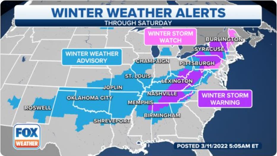
Winter weather alerts stretch from the Southern Plains to the interior Northeast.(FOX Weather)
This storm dumped more than a foot of snow in portions of western Kansas on Thursday, while the Kansas City, Missouri, metro area picked up between 2 and 5 inches of snow.
HOW TO WATCH FOX WEATHER ON TV
As of Friday morning, an expansive band of snow stretched from New Mexico, northern Texas and Oklahoma northeastward into the mid-Mississippi Valley and the southern Great Lakes, as can be seen in the radar loop below.
Here's our current outlook for the storm's timing, followed by the forecast snow amounts. Be sure to download the FOX Weather app for the latest forecast and weather alerts for your exact location, plus our channel's 24/7 livestream.
Winter storm timing
Friday
Snow will spread from as far south as Oklahoma, western and northern Texas and the Ozarks northeastward into the mid-Mississippi Valley and portions of the southern Great Lakes.
The Friday morning and/or evening commute could be slick in many of these areas, including the Dallas/Fort Worth Metroplex.
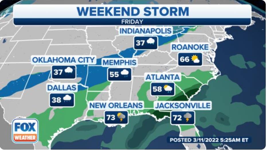
Forecast for Friday, March 11, 2022. (FOX Weather)
Friday night
Rain will change to snow Friday night from portions of the interior Northeast to the Ohio and Tennessee valleys, including as far south as eastern Arkansas, northern Mississippi, northern Alabama and northern Georgia.
Expect slippery roads in these regions as temperatures plunge below freezing overnight, leading to icy spots on any untreated roads into Saturday morning.
RECORD COLD EXPECTED ACROSS SOUTHEAST THIS WEEKEND IN WAKE OF ‘BOMB CYCLONE’
Winds will also pick up Friday night from North Florida to parts of New England as the low-pressure system begins to gain strength near the East Coast.
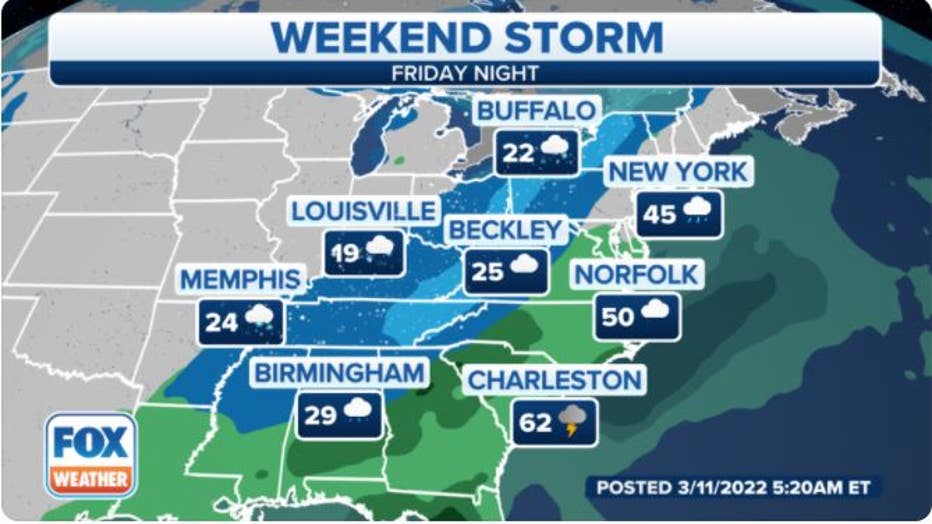
Forecast for Friday night, March 11, 2022. (FOX Weather)
Saturday
Wind-driven snow is expected on Saturday from the Appalachians to portions of Pennsylvania, upstate New York and northern New England. The snow could be heavy at times, with snowfall rates of 1 to 2 inches or more per hour, especially in the interior Northeast.
Along the Interstate 95 urban corridor, rain and even a few thunderstorms could change to a period of wet snow later Saturday or Saturday night from Boston to New York City, Philadelphia and Washington.
High winds are likely across much of the eastern U.S. as the low-pressure system undergoes bombogenesis, with the highest gusts from the coastal Carolinas to the mid-Atlantic coast, central and eastern Pennsylvania, upstate New York and New England.
Downed trees and power outages are possible in those areas, in addition to blowing and drifting snow and significantly reduced visibility where snow is falling. Be prepared for dangerous winter driving conditions from the combination of the snow and high winds.
WHAT YOU SHOULD KNOW ABOUT BLOWING, DRIFTING SNOW
The snow will end from west to east on Saturday night as the storm moves into Atlantic Canada, but slick roads could linger into Sunday morning across the Northeast with temperatures plunging below freezing.
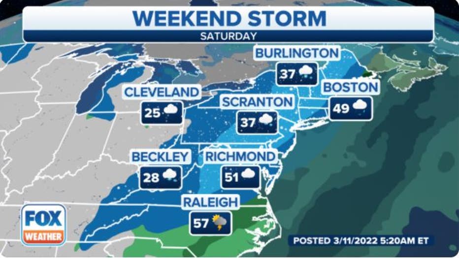
Forecast for Saturday, March 12, 2022. (FOX Weather)
Snow forecast
The interior Northeast will see the heaviest snow from this winter storm, particularly areas from the central Appalachians to central and northern Pennsylvania, upstate New York, Vermont, northern New Hampshire and northern Maine. More than 6 inches will pile up in many of these locations, with some spots receiving a foot or more of snow.
RELATED: Winter storm system to bring several inches of snow to portions of NY, NJ
Most other locations along the path of the storm are expected to pick up less than 6 inches of snow. However, roads could still be slippery as far south as portions of Oklahoma, the Texas Panhandle, the Ozarks and the Tennessee Valley, especially in the hills.
A slushy coating of snow is not ruled out all the way down to northern Mississippi, northern Alabama and northern Georgia, including the Birmingham and Huntsville, Alabama, metro areas and even the northwestern suburbs of Atlanta.
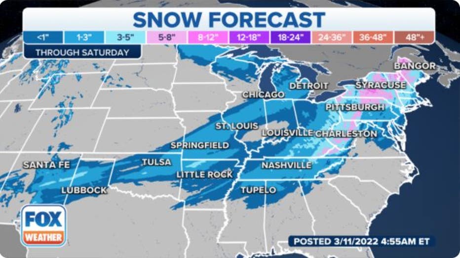
Snowfall forecast through Saturday, March 12, 2022. (FOX Weather)