

Wisconsin winter storm warning; 4-9" of heavy snow possible
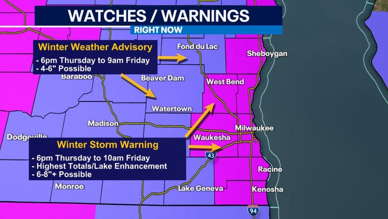
MILWAUKEE - A winter storm warning and winter weather advisory will take effect at 6 p.m. Thursday, March 9 for southeastern Wisconsin through Friday morning.
Snow will start after 4pm and steadily continue throughout the night, with the heaviest snow falling between 8pm and 6am Friday. Expect low visibility and quick accumulation during this time, leading to a messy Friday morning commute. Snow will then taper off west to east between 10am and Noon Friday.
- The winter storm warning will be in effect from 6 p.m. Thursday to 10 a.m. Friday for the following areas: Kenosha County, Milwaukee County, Ozaukee County, Racine County, Sheboygan County, Washington County, Waukesha County.
- The winter weather advisory will be in effect from 6 p.m. Thursday to 9 a.m. Friday for the following areas: Dodge County, Fond Du Lac County, Jefferson County, Walworth County.
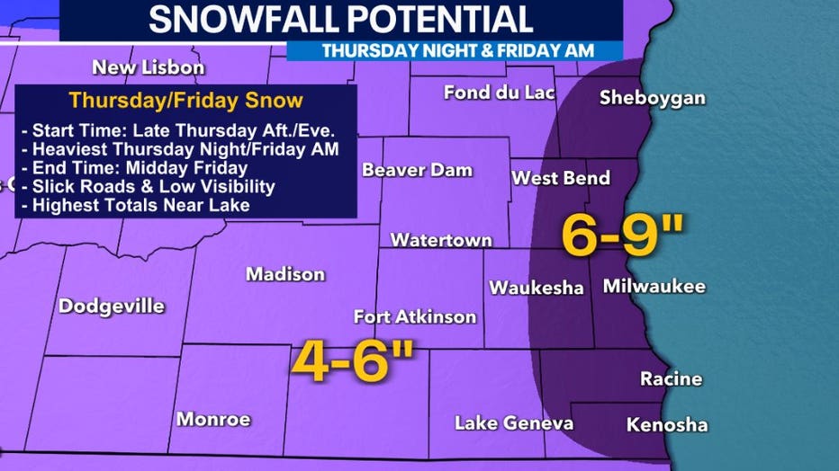
Most areas, especially inland, could pick up around 4-6" of snow with heavier amounts of 6-9" closer to the lake, due to the potential for lake enhancement.
The FOX6 Weather Experts are tracking the storm.
FOX6 Weather Extras
Meanwhile, FOX6Now.com offers a variety of extremely useful weather tools to help you navigate the stormy season. They include the following:
FOX6 Storm Center app

FOX6 News app
FOX Weather app
MAPS AND RADAR
We have a host of maps and radars on the FOX6 Weather page that are updating regularly — to provide you the most accurate assessment of the weather. From a county-by-county view to the Midwest regional radar and a national view — it’s all there.
SCHOOL AND BUSINESS CLOSINGS
When the weather gets a little dicey, schools and businesses may shut down. Monitor the latest list of closings, cancellations, and delays reported in southeast Wisconsin.

FOX6 WEATHER IN SOCIAL MEDIA
- CLICK HERE to "Like" the FOX6 Weather Team on Facebook
- CLICK HERE to "Like" Rob Haswell on Facebook
- CLICK HERE to "Like" Tom Wachs on Facebook
- CLICK HERE to "Like" Stephanie Barichello on Facebook
- CLICK HERE to "Like" Eric Manges on Facebook
- CLICK HERE to "Like" Lisa Michaels on Facebook
- CLICK HERE to "Follow" the FOX6 Weather Team on Twitter
- CLICK HERE to "Follow" Rob Haswell on Twitter
- CLICK HERE to "Follow" Tom Wachs on Twitter
- CLICK HERE to "Follow" Stephanie Barichello on Twitter
- CLICK HERE to "Follow" Eric Manges on Twitter
- CLICK HERE to "Follow" Lisa Michaels on Twitter