

SE Wisconsin storms cause widespread damage, flood watches remain
MILWAUKEE - Southeast Wisconsin experienced another round of severe weather Friday following storms that brought wind, rain, hail, flash floods and, in some areas, tornadoes earlier this week. Follow the latest updates below.
Barns flattened in Franklin
11:00 p.m.:
FOX6 News spoke to a Franklin resident who said it "sounded like a freight train" when an intense storm rolled through Friday night. She said a tree came through her window, and three of four barns on the property were "pretty much flattened."
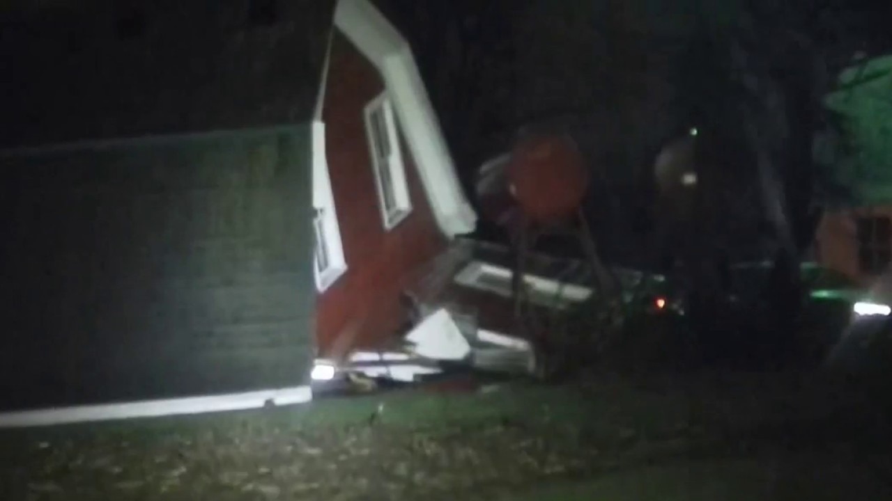
Barns flattened in Franklin during intense storm
FOX6 News spoke to a Franklin resident who said it "sounded like a freight train" when an intense storm rolled through Friday night. She said a tree came through her window, and three of four barns on the property were "pretty much flattened."
WIS-89 shut down
10:45 p.m.:
The Wisconsin Department of Transportation said flooding has shut down State Highway 89 at Anderson Road in Whitewater. It's expected to be closed for hours.
Fox River rising in Waukesha
10:42 p.m.:
The Fox River in downtown Waukesha has flooded over the riverwalk as a fourth round of rain hit the area on Friday night. FOX6's Darronte Matthews showed how water continues to cover walkways and rush beneath bridges.

Fox River flooding in downtown Waukesha
The Fox River in downtown Waukesha has flooded over the riverwalk as a fourth round of rain hit the area on Friday night.
WIS-67 shut down
10:35 p.m.:
The Wisconsin Department of Transportation said State Highway 67 is shut down near Schmidt and Potter Roads in Elkhorn due to standing water in the roadway. It's expected to be blocked for more than two hours.
Storm tears through farm, greenhouse
10:34 p.m.:
L and L Farms and Greenhouse in Caledonia farm took significant damage, including to its greenhouse, during Friday night's storms – days before the owner planned to open. He said there are animals on the property, but they are OK.

Storm tears through Caledonia farm, greenhouse
L and L Farms and Greenhouse in Caledonia farm took significant damage, including to its greenhouse, during Friday night's storms -- days before the owner planned to open. He said there are animals on the property, but they are OK.
Flash flood warnings canceled
10:15 p.m.:
All remaining National Weather Service flash flood warnings were canceled for southeast Wisconsin. Other flood warnings and watches remain in effect, some into early Saturday morning. Check for the latest alerts here.
WIS-120 shut down
10:11 p.m.:
The Wisconsin Department of Transportation said State Highway 120 is shut down in both directions near the state line in Walworth County due to standing water on the roadway. It's expected to take more than two hours to clear.
Waukesha bridge flooded
9:49 p.m.:
The Madison Street bridge in downtown Waukesha is closed due to flooding. The city advised the public not to enter flooded roadways or go around barricades.
Power outages
9:45 p.m.:
We Energies has crews investigating damage and restoring power in the wake of severe storms that hit southeast Wisconsin on Friday night. A spokesperson said crews will work as quickly and safely as possible around the clock until power is restored for all customers.
Everyone should stay at least 25 feet away from downed power lines and storm debris, and report any outages to We Energies.
Tornado watch canceled
9:16 p.m.:
The National Weather Service canceled the tornado watch for Milwaukee, Kenosha, Ozaukee, Racine, Walworth, Washington and Waukesha counties. It had previously been scheduled to run until 10 p.m.
Airport operations
9:04 p.m.:
Milwaukee Mitchell International Airport said it briefly issued a shelter-in-place alert due to a National Weather Service tornado warning that had been issued at around 8 p.m. The airport said there were no tornadoes reported at the airport itself, and no damage has been reported. Normal operations have resumed.
Tornado warnings expire, watches remain
8:36 p.m.:
The last of the remaining tornado warnings, which included Kenosha and Racine counties, expired. Tornado watches for several counties – Milwaukee, Kenosha, Ozaukee, Racine, Walworth, Washington, Waukesha – remain in effect until 10 p.m.
Tornado warning expires
8:36 p.m.:
The tornado warning that covered southern Milwaukee County expired.
Severe thunderstorm warning
8:12 p.m.:
The National Weather Service issued a severe thunderstorm warning for southeastern Milwaukee County and east-central Waukesha County until 9 p.m. A storm could produce nickel-sized hail and 70 mph wind gusts.
Airport tornado report
8:03 p.m.:
Milwaukee Mitchell International Airport reported a visual on at least one tornado, if not two, in Milwaukee County.
Tornado warning
7:56 p.m.:
The National Weather Service issued a tornado warning for southern Milwaukee County and southeastern Waukesha County until 8:45 p.m. A severe thunderstorm could produce a tornado and quarter-sized hail. Flying debris could damage homes, vehicles and trees.
Tornado warning
7:34 p.m.:
The National Weather Service issued a tornado warning for all of Racine and Kenosha counties, as well as southeast Walworth County, until 8:45 p.m. on Friday. A severe thunderstorm capable of producing a tornado could cause damage in areas including Union Grove, Mount Pleasant, Pleasant Prairie and Kenosha.
Flash flood warning
7:34 p.m.:
The National Weather Service issued a flash flood warning for Milwaukee County, Waukesha County and portions of Jefferson, Racine and Walworth counties until 10:45 p.m. Small creeks and streams, urban areas, highways, streets, underpasses and other poor drainage or low-lying areas could experience flash floods as rain continues to fall.
Tornado warning
7:34 p.m.:
The National Weather Service issued a tornado warning for northwest Racine County and southeast Waukesha County until 8 p.m. A storm could produce a tornado near New Berlin, Muskego, Waterford or other areas.
Tornado watch extended
7:33 p.m.:
The National Weather Service extended a tornado watch until 10 p.m. for Kenosha, Milwaukee, Ozaukee, Racine, Walworth, Washington and Waukesha counties.
The tornado watch was canceled for Dodge, Fond du Lac, Jefferson and Sheboygan counties.
Severe thunderstorm warning
7:24 p.m.:
The National Weather Service issued severe thunderstorm warnings for parts of Jefferson, Walworth and Waukesha counties until 8:15 p.m. The storm could produce 70 mph winds and ping pong ball-sized hail.
Minutes later, a severe thunderstorm warning was added for parts of Milwaukee, Ozaukee, Washington and Waukesha counties – also until 8:15 p.m. It could produce 60 mph winds and penny-sized hail in those areas.
Tornado warning
7:11 p.m.:
The National Weather Service issued a tornado warning for east-central Walworth County, southwestern Racine County and northwestern Kenosha County until 8 p.m. That could include the Lake Geneva, Rochester and Wheatland areas.
Tornado warning
7:08 p.m.:
The National Weather Service issued a tornado warning for central Waukesha County until 7:45 p.m. A severe thunderstorm could produce tornadoes or quarter-sized hail.
Severe thunderstorm warning
7:05 p.m.:
The National Weather Service issued severe thunderstorm warnings for southern Milwaukee County, as well as parts of Kenosha, Racine, Walworth and Waukesha counties until 8:15 p.m. A thunderstorm spotted near Mukwonago and moving east could produce half-dollar-sized hail and wind gusts of 60 mph.
Flash flood warning
7:02 p.m.:
The National Weather Service issued flash flood warnings for southeast Jefferson and northwest Walworth County until 10:15 p.m. on Friday. Small creeks and streams, urban areas, streets and other poor drainage, low-lying areas are susceptible.
Tornado warning
6:51 p.m.:
The National Weather Service expanded a tornado warning to include central Walworth County until 7:15 p.m. A severe thunderstorm capable of producing a tornado was spotted over Delavan.
Tornado warning
6:45 p.m.:
The National Weather Service issued a tornado warning for northwestern Jefferson County and southwestern Dodge County until 7:30 p.m.
Tornado warning
6:41 p.m.:
The National Weather Service extended a tornado warning for northwestern Walworth County until 7:15 p.m. That includes the Whitewater and Palmyra areas.
Severe thunderstorm warning
6:39 p.m.:
The National Weather Service issued a severe thunderstorm warning for parts of Fond du Lac, Ozaukee, Sheboygan and Washington counties until 7:30 p.m. The storm could produce damaging wind gusts and penny-sized hail.
Rock County tornado
6:28 p.m.:
The National Weather Service reported a tornado in Avalon, roughly 10 miles southeast of Janesville, that happened at 6:09 p.m. There were reports of snapped and uprooted trees, damage to homes and more.
Severe thunderstorm warning
6:24 p.m.:
The National Weather Service issued a severe thunderstorm warning for northwestern Jefferson County until 7:15 p.m. Minutes later, a warning was expanded to southeastern Jefferson County, southwestern Waukesha County and all of Walworth County until 7:30 p.m. – it could bring two-inch hail.
Tornado warning
6:18 p.m.:
The National Weather Service issued a tornado warning for northwestern Walworth County until 6:45 p.m. A severe thunderstorm could bring tornadoes and quarter-sized hail.
Tornado warning
6:05 p.m.:
The National Weather Service issued a tornado warning for southwestern Waukesha County and southeastern Jefferson County until 6:30 p.m. The NWS said there were multiple reports of a tornado near Janseville that was moving northeast. However, the warning was almost immediately cleared.
Severe thunderstorm warning
5:48 p.m.:
The National Weather Service issued a severe thunderstorm warning for southeastern Fond du Lac County, northwestern Washington County and southwestern Sheboygan County until 6:30 p.m. It could produce quarter-sized hail and gusts of 60 mph.
Minutes later, a severe thunderstorm warning for western Washington County and eastern Dodge County was issued until 6:45 p.m. The storm could produce half-dollar-sized hail and strong winds.
Severe thunderstorm warning
5:26 p.m.:
The National Weather Service issued a severe thunderstorm warning for western Walworth County until 6:15 p.m. NWS described it as a "destructive storm" with baseball-sized hail and 60 mph wind gusts.
Severe thunderstorm warning
5:26 p.m.:
The National Weather Service issued severe thunderstorm warnings for southeastern Walworth County, southwestern Waukesha County and southern Jefferson County until 6:30 p.m. Ping pong ball-sized hail and wind gusts of 70 mph are possible.
Severe thunderstorm warning
5:16 p.m.:
The National Weather Service issued severe thunderstorm warnings for northern Jefferson County and southwestern Dodge County until 6:15 p.m. Hazards include wind gusts of 60 mph and quarter-sized hail.
Dodge County tornado warning
4:28 p.m.:
The National Weather Service issued a tornado warning for southwestern Dodge County until 5:15 p.m. Minutes later, the NWS issued a severe thunderstorm warning for parts of Dane and Jefferson County until the same time.
St. 27th Street closed at Root River
4:27 p.m.:
WIS 241 (27th Street) in the city of Frankin is currently closed due high water levels at the Root River.
Milwaukee DPW crews at work
4:21 p.m.:
Milwaukee DPW Crews are actively street sweeping, clearing debris, and ensuring catch basins and storm drains are clear, officials say. They have been deployed to areas known for flooding, where barricades have been staged and teams will be proactively monitoring conditions as rain begins.
Tornado warnings issued far west
3:44 p.m.:
Several tornado warnings issued out west. They will be heading into our area over the next few hours. You can expect all threats to be on the table (tornadoes, wind, hail, and flooding).
Flood watch in SE Wisconsin
3:05 p.m.:
The National Weather Service has issued a flood watch for all of southeast Wisconsin in effect until 7 a.m. on Saturday, April 18.
Historic flooding along Wisconsin River
1:48 p.m.:
The Wisconsin DNR announced that officials are responding to historic flooding along the Wisconsin River as water levels continue to rise, placing significant strain on levee systems and threatening to breach in the Portage area. There is concern regarding the integrity of the Caledonia Levee, south of Highway 33 near Blackhawk Park.
The levees continue to be monitored 24 hours a day, and crews are working to extend sandbag blockades.
Severe storms building: Tornado watch issued
12:44 p.m.:
A Tornado Watch has been issued for all of southeastern Wisconsin until 8 p.m.
That includes Walworth, Jefferson, Waukesha, Racine, Kenosha, Milwaukee, Ozaukee, Washington, Dodge, Fond du Lac, and Sheboygan Counties.

Severe storms building: Tornado watch imminent
12:20 p.m.:
An update from the Storm Prediction Center highlights the growing risk for supercells capable of all hazards, including tornadoes, large hail, and damaging winds.
A Tornado Watch is likely within the next 1–2 hours, covering parts of southern and western Wisconsin.

Fox River in Burlington
11:55 a.m.:
The National Weather Service has projected the Fox River flood level in Burlington to be as high as 12 ½ feet by Friday evening. A news release says this is around moderate flood stage.
Property owners are encouraged to monitor the Fox and White River levels and expect increased flooding into late evening.
Although the exact extent of potential flooding cannot be predicted, Racine County Emergency Management is coordinating with the City of Burlington and Racine County resources to provide sand and sandbags for public use after 2 p.m. at the 600 block of Maryland Avenue in the City of Burlington.
Tracking potential for severe weather
10:30 a.m.:
Our active weather setup is on track across southern Wisconsin for Friday, bringing both a severe weather threat and another round of heavy rainfall.
Storms are expected to develop in southwestern Wisconsin this afternoon, initially as discrete super-cells capable of producing large hail, damaging winds, and a few tornadoes. As the evening progresses, these storms will likely organize into a line and push east across the rest of southern Wisconsin. By tonight, storms become more progressive and begin to clear as a cold front moves through.
FREE DOWNLOAD: Get breaking news alerts in the FOX LOCAL Mobile app for iOS or Android
One notable update is the eastward expansion of the higher-end severe risk into south-central Wisconsin, reinforcing the need for close monitoring through the late afternoon and evening hours.

Rainfall and flooding concerns
In addition to the severe threat, storms will be efficient rain producers. Most areas can expect an additional 0.75 to 2 inches of rain, with localized totals exceeding 2.00 inches possible.
The highest rainfall potential is focused across western parts of the region, where multiple rounds of storms may track over the same areas. Farther east, storms are expected to move faster, which should help limit how long heavy rain lingers.
This is a classic spring setup with multiple hazards in play. Stay weather aware through the afternoon and evening, and be prepared to act quickly if warnings are issued. We will post live updates here throughout the event.
You can find a more detailed forecast from the FOX6 Weather Experts on our weather page.
FOX6 Weather Extras
Local perspective:
Meanwhile, FOX6Now.com offers a variety of extremely useful weather tools to help you navigate the stormy season. They include the following:
FOX6 Storm Center app

FOX LOCAL Mobile app
FOX Weather app
Maps and radar
We have a host of maps and radars on the FOX6 Weather page that are updating regularly — to provide you the most accurate assessment of the weather. From a county-by-county view to the Midwest regional radar and a national view — it’s all there.
SIGN UP TODAY: Get daily headlines, breaking news emails from FOX6 News
School and business closings
When the weather gets a little dicey, schools and businesses may shut down. Monitor the latest list of closings, cancellations, and delays reported in southeast Wisconsin.

FOX6 Weather Experts in social media
- CLICK HERE to "Like" the FOX6 Weather Team on Facebook
- CLICK HERE to "Like" Rob Haswell on Facebook
- CLICK HERE to "Like" Tom Wachs on Facebook
- CLICK HERE to "Like" Stephanie Barichello on Facebook
- CLICK HERE to "Like" Lisa Michaels on Facebook
- CLICK HERE to "Like" Holly Baker on Facebook
- CLICK HERE to "Follow" the FOX6 Weather Team on X
- CLICK HERE to "Follow" Rob Haswell on X
- CLICK HERE to "Follow" Tom Wachs on X
- CLICK HERE to "Follow" Stephanie Barichello on X
- CLICK HERE to "Follow" Lisa Michaels on X
- CLICK HERE to "Follow" Holly Baker on X
The Source: Information in this post was compiled by the FOX6 Weather Experts.