


Francine strengthens into hurricane as Texas, Louisiana rush preparations
Hurricane Francine has intensified into a Category 1 hurricane in the Gulf of Mexico and is forecast to make landfall in Louisiana on Wednesday.
Hurricane Francine has intensified into a Category 1 hurricane in the Gulf of Mexico and is forecast to make landfall in Louisiana on Wednesday.
Weather Webcast with Chief Meteorologist Tom Wachs
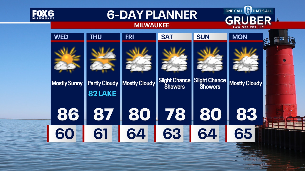
Wildfire smoke possible in our skies for the next few days, otherwise only a slight chance for a rain shower tonight and Wednesday morning. Mostly sunny and warm on Wednesday with highs in the mid-80s.
Wildfire smoke possible in our skies for the next few days, otherwise only a slight chance for a rain shower tonight and Wednesday morning. Mostly sunny and warm on Wednesday with highs in the mid-80s.

How humidity, evaporation work together
FOX6 Chief Meteorologist Tom Wachs explains the relationship between humidity and evaporation.
FOX6 Chief Meteorologist Tom Wachs explains the relationship between humidity and evaporation.
Weather webcast with Rob Haswell
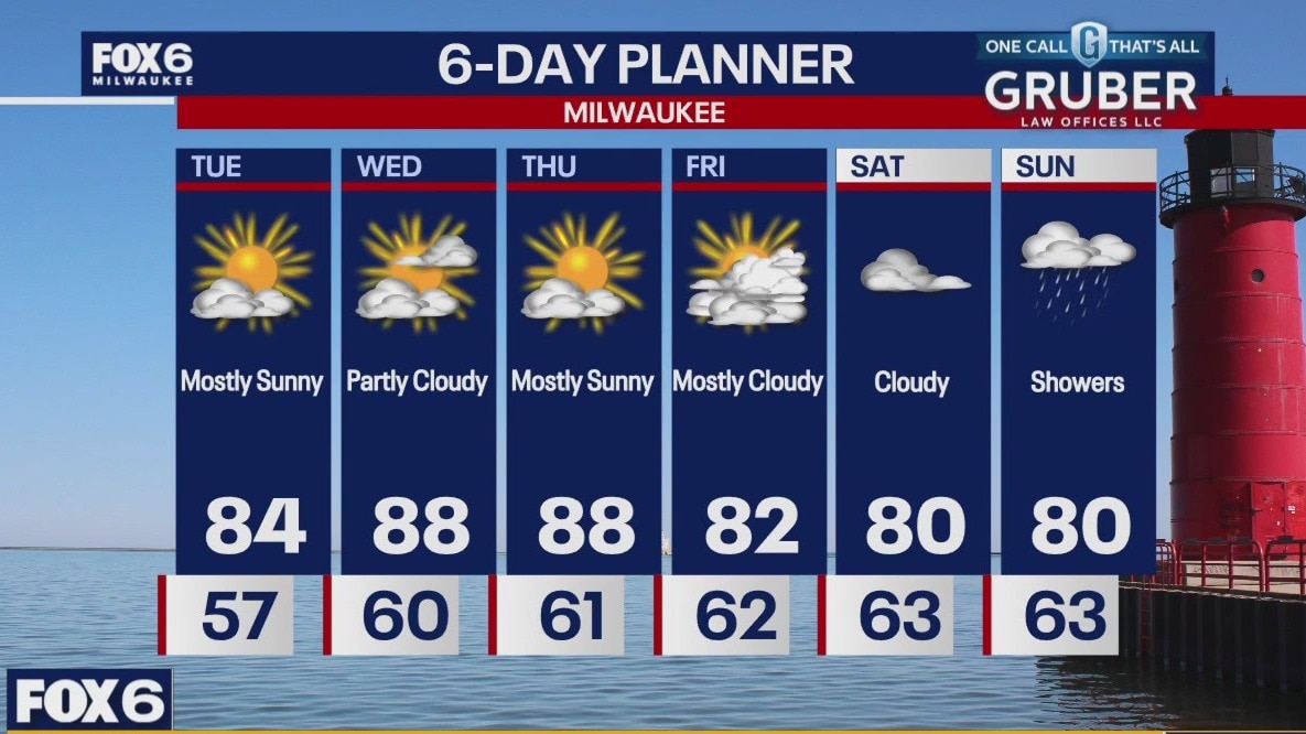
We continue to see warmer air moving into our area today with highs reaching the low to mid 80s. We will continue to warm into the upper 80s Wednesday and Thursday and only cool slightly after that. A dry forecast persists with only a very slight chance of rain early Wednesday and into Saturday afternoon. The most likely chance of rain waits until Saturday night into Sunday.
We continue to see warmer air moving into our area today with highs reaching the low to mid 80s. We will continue to warm into the upper 80s Wednesday and Thursday and only cool slightly after that. A dry forecast persists with only a very slight chance of rain early Wednesday and into Saturday afternoon. The most likely chance of rain waits until Saturday night into Sunday.
Weather Webcast with Chief Meteorologist Tom Wachs
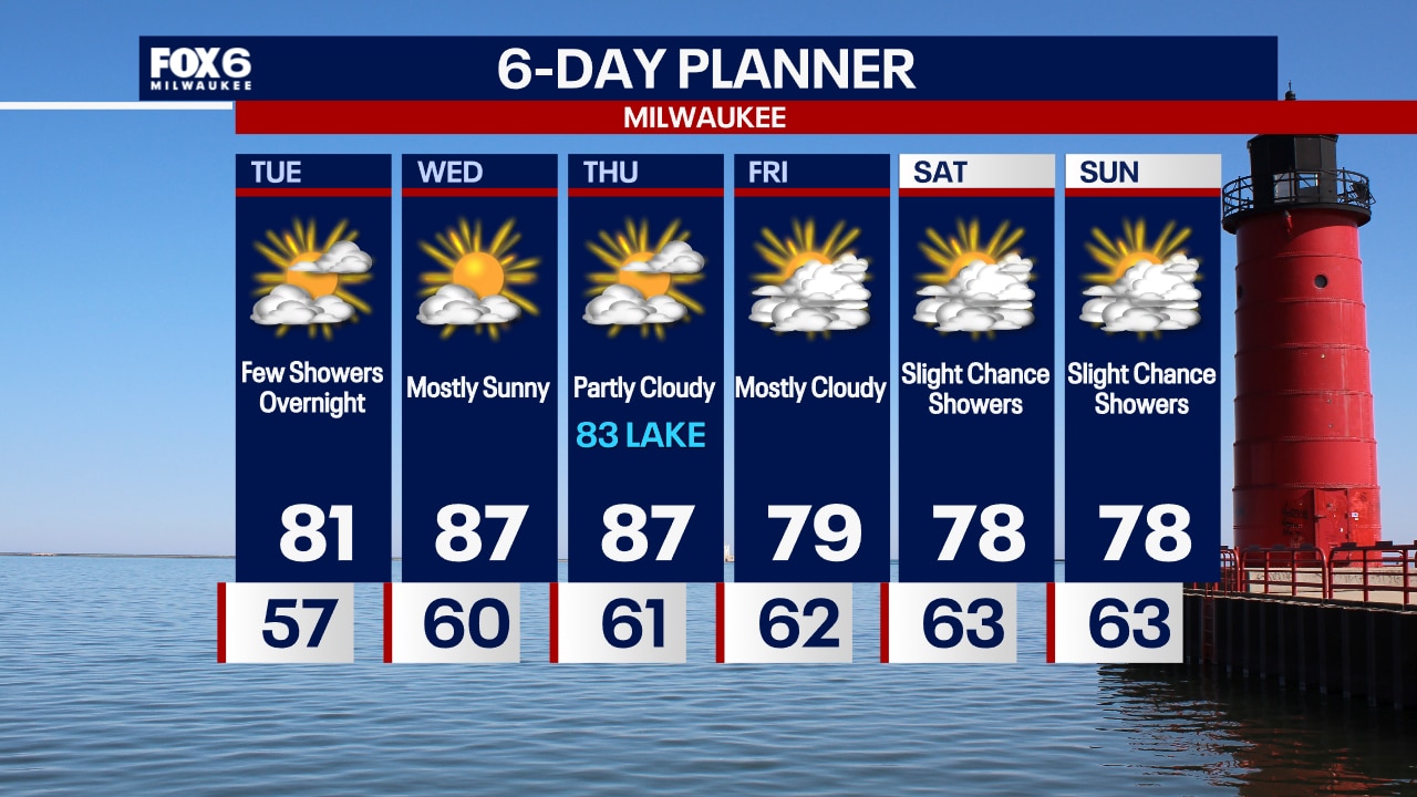
Clear skies overnight with temperatures in the 50s by sunrise. Mostly sunny, breezy and warm again on Tuesday with highs in the low 80s.
Clear skies overnight with temperatures in the 50s by sunrise. Mostly sunny, breezy and warm again on Tuesday with highs in the low 80s.
Weather Webcast with Chief Meteorologist Tom Wachs
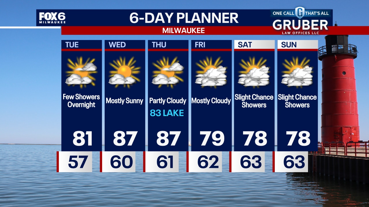
Clear skies tonight with temperatures dropping through the 60s. Partly sunny, breezy and warm again on Tuesday. Highs in the low 80s. A few rain showers are possible late Tuesday night.
Clear skies tonight with temperatures dropping through the 60s. Partly sunny, breezy and warm again on Tuesday. Highs in the low 80s. A few rain showers are possible late Tuesday night.


Geomagnetic storm watch issued, could produce auroras visible in US
The strongest impacts are expected to arrive on Tuesday, which could produce aurora lights father away from Earth’s poles, including in parts of the U.S.
The strongest impacts are expected to arrive on Tuesday, which could produce aurora lights father away from Earth’s poles, including in parts of the U.S.


Tropical Storm Francine forms in Gulf of Mexico, forecast to strengthen into hurricane: NHC
Tropical Storm Francine has formed in the Gulf of Mexico, becoming the sixth named storm of the hurricane season a day before the official peak of the season, the NHC reported.
Tropical Storm Francine has formed in the Gulf of Mexico, becoming the sixth named storm of the hurricane season a day before the official peak of the season, the NHC reported.


Daylight saving time 2024: When will we 'fall back?'
At the end of daylight saving time, early-risers will get an extra hour of rest before alarm clocks go off, but it will get darker earlier in the evenings.
At the end of daylight saving time, early-risers will get an extra hour of rest before alarm clocks go off, but it will get darker earlier in the evenings.

Weather webcast with Rob Haswell
High pressure continues to dominate our forecast for mostly sunny and dry conditions this week. A wildfire to our NW could also send us a bit of smoke today for a hazy sunshine at times. We stay dry for the next several days. Our next chance of rain isn't until later in the day on Saturday and even then is only slight.
High pressure continues to dominate our forecast for mostly sunny and dry conditions this week. A wildfire to our NW could also send us a bit of smoke today for a hazy sunshine at times. We stay dry for the next several days. Our next chance of rain isn't until later in the day on Saturday and even then is only slight.
Weather Webcast with Chief Meteorologist Tom Wachs
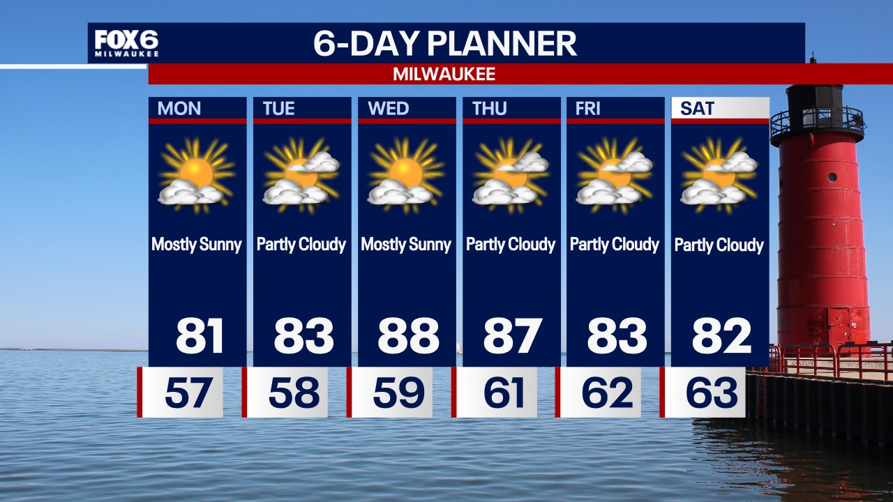
Clear and breezy overnight with temperatures in the 50s by sunrise. Mostly sunny, breezy and warmer on Monday with highs in the low 80s.
Clear and breezy overnight with temperatures in the 50s by sunrise. Mostly sunny, breezy and warmer on Monday with highs in the low 80s.
Weather Webcast with Chief Meteorologist Tom Wachs
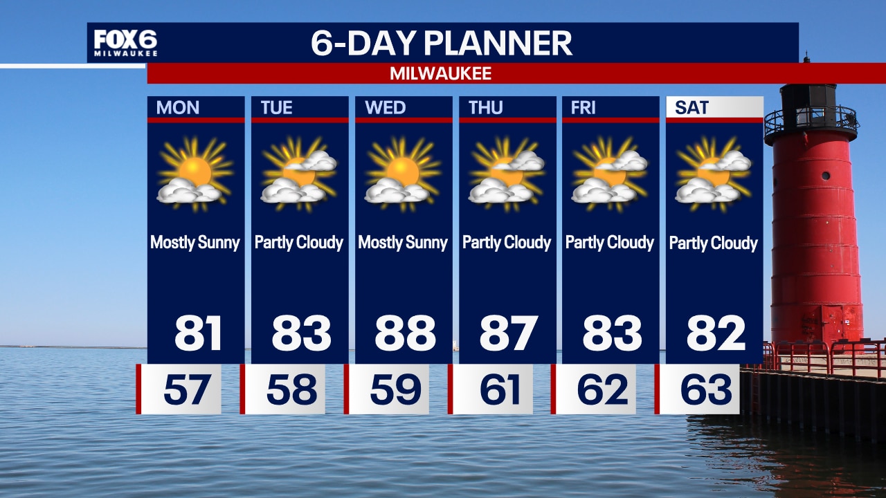
Clear and breezy tonight with temperatures dropping through the 60s. Mostly sunny, breezy and warmer on Monday with highs in the low 80s.
Clear and breezy tonight with temperatures dropping through the 60s. Mostly sunny, breezy and warmer on Monday with highs in the low 80s.
Weather webcast with Rob Haswell
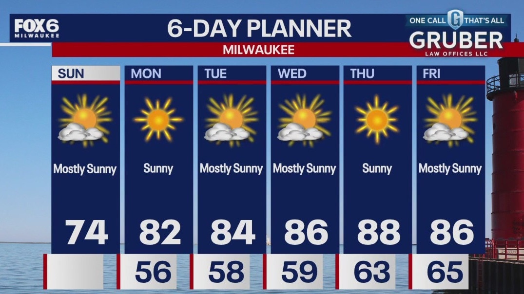
Mostly clear skies tonight with another cool evening as temps will drop into the low to mid 40s by Sunday morning. Mostly sunny skies on Sunday with high temps slightly warmer in the low to mid 70s. Winds begin to change out of the south heading into next week.
Mostly clear skies tonight with another cool evening as temps will drop into the low to mid 40s by Sunday morning. Mostly sunny skies on Sunday with high temps slightly warmer in the low to mid 70s. Winds begin to change out of the south heading into next week.
Weather webcast with Lisa Michaels
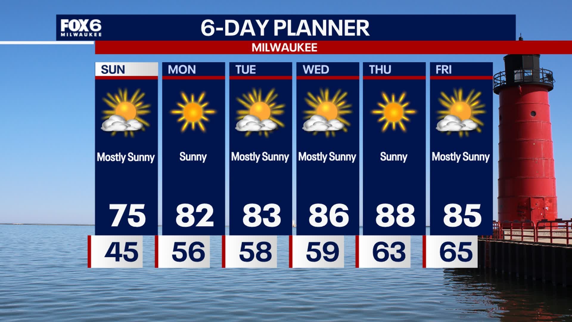
Mostly clear skies tonight with another cool evening as temps will drop into the low to mid 40s by Sunday morning. Mostly sunny skies on Sunday with high temps slightly warmer in the low to mid 70s. Winds begin to change out of the south heading into next week. This will continue to bring a warming trend back into the upper 80s by the end of next week! A long dry and sunny stretch of weather will be with us all week.
Mostly clear skies tonight with another cool evening as temps will drop into the low to mid 40s by Sunday morning. Mostly sunny skies on Sunday with high temps slightly warmer in the low to mid 70s. Winds begin to change out of the south heading into next week. This will continue to bring a warming trend back into the upper 80s by the end of next week! A long dry and sunny stretch of weather will be with us all week.
Weather webcast with Rob Haswell
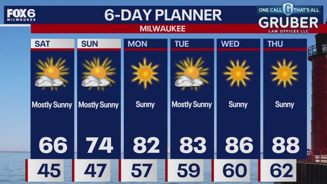
High pressure to our west and a low far to our east are combining to ramp up our wind from the north today. As a result, we will see cold air continue to flood our area with highs in the low to mid 60s today.
High pressure to our west and a low far to our east are combining to ramp up our wind from the north today. As a result, we will see cold air continue to flood our area with highs in the low to mid 60s today.
Weather webcast with Lisa Michaels
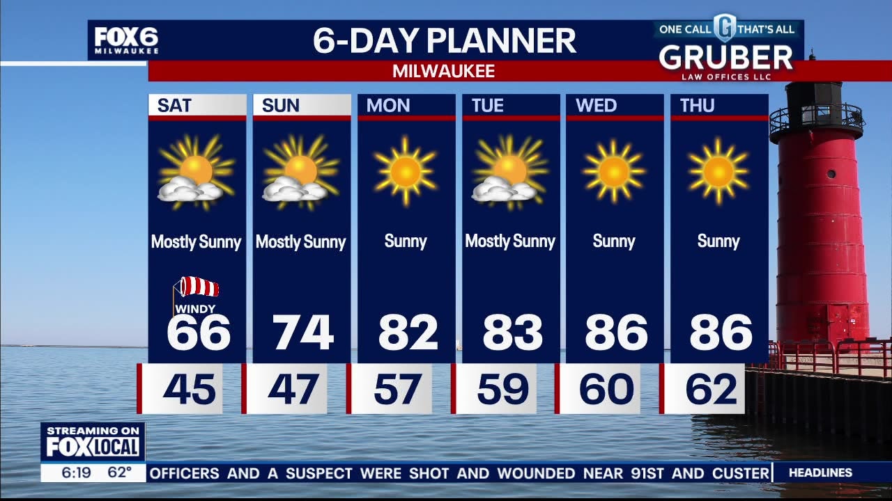
Cool with lows in the low to mid 40s. A few upper 30s inland are possible into Saturday morning. Mostly sunny and cool on Saturday. Highs in the mid 60s with winds off the lake creating dangerous swim conditions through Saturday afternoon due to high waves and rip currents. Mostly sunny on Sunday with highs back in the middle 70s. Warming back into the low and mid 80s next week with more dry days in sight!
Cool with lows in the low to mid 40s. A few upper 30s inland are possible into Saturday morning. Mostly sunny and cool on Saturday. Highs in the mid 60s with winds off the lake creating dangerous swim conditions through Saturday afternoon due to high waves and rip currents. Mostly sunny on Sunday with highs back in the middle 70s. Warming back into the low and mid 80s next week with more dry days in sight!


Future Forecaster: Meet 12-year-old Camila
Meet 12-year-old Camila -- our latest Future Forecaster.
Meet 12-year-old Camila -- our latest Future Forecaster.

Camila helps Rob Haswell with the weather
She wanted to be a Future Forecaster -- and that's exactly what FOX6 WakeUp News is helping her?accomplish.
She wanted to be a Future Forecaster -- and that's exactly what FOX6 WakeUp News is helping her?accomplish.

Future Forecaster: Meet 12-year-old Camila
Meet 12-year-old Camila -- our latest Future Forecaster.
Meet 12-year-old Camila -- our latest Future Forecaster.
Weather webcast with Rob Haswell
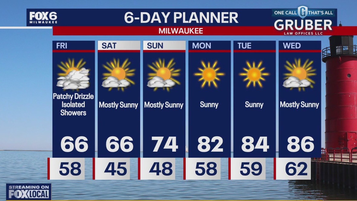
Behind yesterday's low, we remain cloudy with drizzle and a chance for a few showers but the biggest impact is the change in temperatures. We will be in the low to mid 60s this afternoon after hitting 86 yesterday at MKE. The steady NNW wind will make it feel cooler as well. The windy conditions will make for high waves and rough currents in Lake Michigan and NWS has issued a Beach Hazards Statement for our lakeshore areas. We will be cool again tomorrow but rebound back to the low to mid 80s by next week.
Behind yesterday's low, we remain cloudy with drizzle and a chance for a few showers but the biggest impact is the change in temperatures. We will be in the low to mid 60s this afternoon after hitting 86 yesterday at MKE. The steady NNW wind will make it feel cooler as well. The windy conditions will make for high waves and rough currents in Lake Michigan and NWS has issued a Beach Hazards Statement for our lakeshore areas. We will be cool again tomorrow but rebound back to the low to mid 80s by next week.