


Weather Webcast with Stephanie Barichello
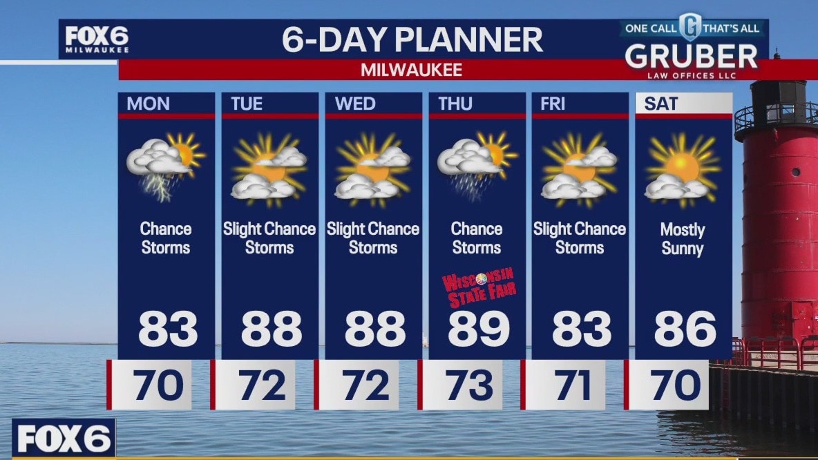
Scattered showers and a few thunderstorms this afternoon, plus very humid. Patchy fog tonight then more sunshine Tuesday. It'll be hotter with temperatures in the upper 80s. Storms are possible in the afternoon, and again Wednesday into Thursday. High humidity sticks around all week.
Scattered showers and a few thunderstorms this afternoon, plus very humid. Patchy fog tonight then more sunshine Tuesday. It'll be hotter with temperatures in the upper 80s. Storms are possible in the afternoon, and again Wednesday into Thursday. High humidity sticks around all week.
Weather webcast with Lisa Michaels
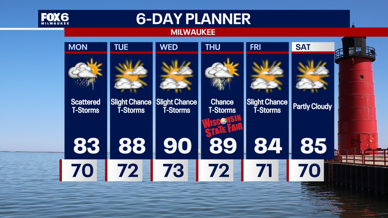
Patchy fog in the morning. Scattered showers and storms today. Better chances in the morning and early afternoon. These will produce heavy rain. Upper 70s to low 80s on Monday and very humid conditions. Expect very humid conditions to continue throughout the entire week along with slight chances for t-storms. A greater chance for t-storms moves in on Thursday, but they will be scattered. Highs in the 80s this week, warming to around 90 on Wednesday and Thursday.
Patchy fog in the morning. Scattered showers and storms today. Better chances in the morning and early afternoon. These will produce heavy rain. Upper 70s to low 80s on Monday and very humid conditions. Expect very humid conditions to continue throughout the entire week along with slight chances for t-storms. A greater chance for t-storms moves in on Thursday, but they will be scattered. Highs in the 80s this week, warming to around 90 on Wednesday and Thursday.
Weather Webcast with Chief Meteorologist Tom Wachs
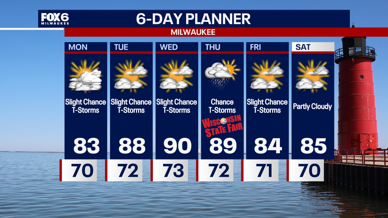
Very humid overnight with patchy fog and a slight chance for a t-storm. Temperatures in the 70s. Mostly cloudy with scattered t-storms on Monday. Staying humid with highs in the low 80s.
Very humid overnight with patchy fog and a slight chance for a t-storm. Temperatures in the 70s. Mostly cloudy with scattered t-storms on Monday. Staying humid with highs in the low 80s.
Weather Webcast with Chief Meteorologist Tom Wachs
Scattered showers & t-storms with heavy rain will taper off this evening. The humidity will be sticking around, however. Temperatures in the 70s all night.
Scattered showers & t-storms with heavy rain will taper off this evening. The humidity will be sticking around, however. Temperatures in the 70s all night.

Weather webcast with Lisa Michaels
More cloud cover on Sunday with a chance for showers and storms especially in the afternoon. Heavy rain will be the primary threat. Higher dew points arrive Sunday afternoon back in the upper 60s to low 70s. These oppressive conditions will continue through all next week. Temperatures will also heat up pushing the upper 80s to 90F Tuesday through Thursday. A slight chance daily for showers and storms. A few days could have strong storms possible.
More cloud cover on Sunday with a chance for showers and storms especially in the afternoon. Heavy rain will be the primary threat. Higher dew points arrive Sunday afternoon back in the upper 60s to low 70s. These oppressive conditions will continue through all next week. Temperatures will also heat up pushing the upper 80s to 90F Tuesday through Thursday. A slight chance daily for showers and storms. A few days could have strong storms possible.

Weather Webcast with Chief Meteorologist Rob Haswell
Getting hot and sticky ahead!
Getting hot and sticky ahead!

Weather Webcast with Chief Meteorologist Rob Haswell
Looking to get a lot hotter and far more humid in the days ahead!
Looking to get a lot hotter and far more humid in the days ahead!

Weather webcast with Lisa Michaels
Mostly sunny Saturday with highs in the low to mid 80s. Slightly more humid. A light lake breeze this afternoon putting temps in the upper 70s lakeside. Clouds increase Saturday night but staying dry. This will keep evening temps in the low 60s by Sunday morning. A few showers possible early Sunday. Better chances for additional showers/storms during the afternoon although not a washout. Hot and humid conditions return for a long stretch this week with almost daily chances for showers/storms.
Mostly sunny Saturday with highs in the low to mid 80s. Slightly more humid. A light lake breeze this afternoon putting temps in the upper 70s lakeside. Clouds increase Saturday night but staying dry. This will keep evening temps in the low 60s by Sunday morning. A few showers possible early Sunday. Better chances for additional showers/storms during the afternoon although not a washout. Hot and humid conditions return for a long stretch this week with almost daily chances for showers/storms.

Weather Webcast with Stephanie Barichello
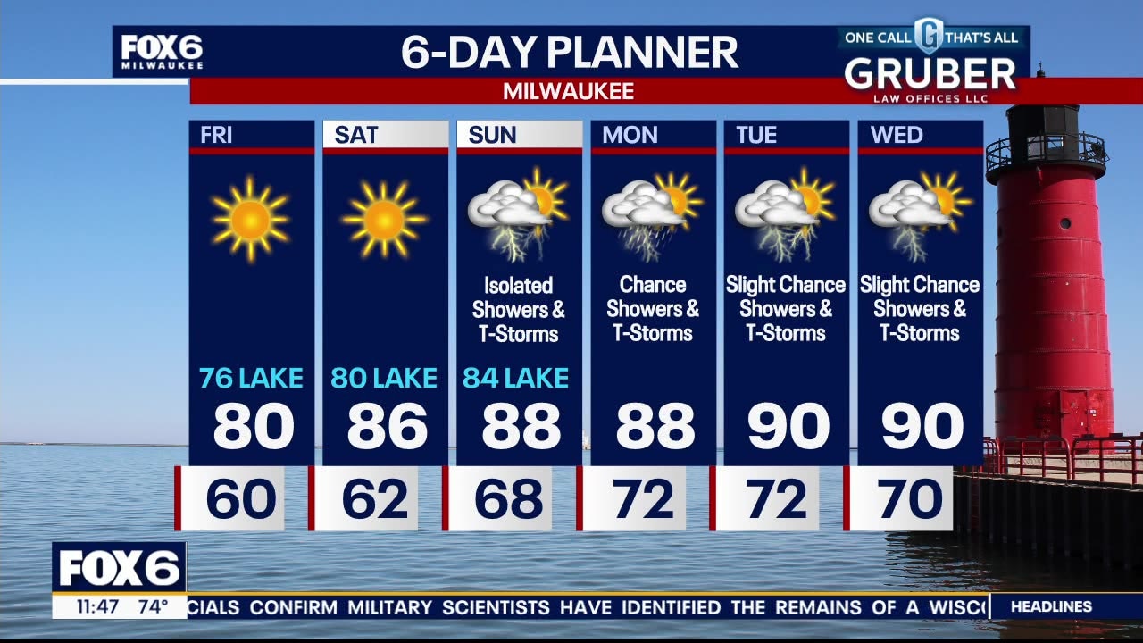
A gorgeous evening ahead for the many festivals and fairs going on! Temperatures fall into the 60s tonight, then we're all back to near normal Saturday with highs in the low 80s. Dewpoints will be slightly higher. Dewpoints soar into the 70s Sunday with a chance for storms in the afternoon, although it will not be a washout. Warm and very humid all of next week.
A gorgeous evening ahead for the many festivals and fairs going on! Temperatures fall into the 60s tonight, then we're all back to near normal Saturday with highs in the low 80s. Dewpoints will be slightly higher. Dewpoints soar into the 70s Sunday with a chance for storms in the afternoon, although it will not be a washout. Warm and very humid all of next week.
Weather webcast with Lisa Michaels
High pressure again dominates our forecast and as the high shifts to the east, we warm a but on a more southerly flow of air. Highs will reach the upper 70s to near 80 inland but stay in the low to mid 70s lakeside with a breeze off Lake Michigan through the afternoon. Another sunny day for Saturday with warmer highs in the mid-80s but again cooler near the lake. We become much hotter and more active from Sunday through Wednesday day of next week.
High pressure again dominates our forecast and as the high shifts to the east, we warm a but on a more southerly flow of air. Highs will reach the upper 70s to near 80 inland but stay in the low to mid 70s lakeside with a breeze off Lake Michigan through the afternoon. Another sunny day for Saturday with warmer highs in the mid-80s but again cooler near the lake. We become much hotter and more active from Sunday through Wednesday day of next week.


Future Forecaster: Meet 8-year-old Gabriel
Meet 8-year-old Gabriel -- our latest Future Forecaster.
Meet 8-year-old Gabriel -- our latest Future Forecaster.

Gabriel helps Rob Haswell with the weather
Meet 8-year-old Gabriel -- our latest Future Forecaster.
Meet 8-year-old Gabriel -- our latest Future Forecaster.

Future Forecaster: Meet 8-year-old Gabriel
He wanted to be a Future Forecaster -- and that's exactly what FOX6 WakeUp News is helping him?accomplish.
He wanted to be a Future Forecaster -- and that's exactly what FOX6 WakeUp News is helping him?accomplish.
Weather webcast with Rob Haswell
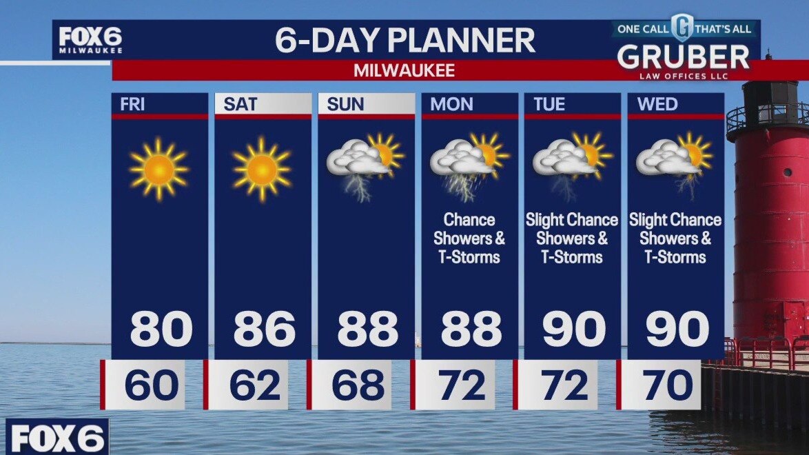
High pressure again dominates our forecast and as the high shifts to the east, we warm a bit on a more southerly flow of air. Highs will reach the upper 78s to near 80 inland but stay in the low to mid 70s lakeside with a breeze off Lake Michigan through the afternoon. Another sunny day for Saturday with warmer highs in the mid-80s but again cooler near the lake. We will become much hotter and more active from Sunday through Wednesday of next week.
High pressure again dominates our forecast and as the high shifts to the east, we warm a bit on a more southerly flow of air. Highs will reach the upper 78s to near 80 inland but stay in the low to mid 70s lakeside with a breeze off Lake Michigan through the afternoon. Another sunny day for Saturday with warmer highs in the mid-80s but again cooler near the lake. We will become much hotter and more active from Sunday through Wednesday of next week.
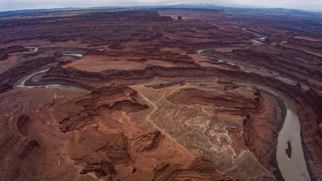

Woman dies after running out of water, hiking near Utah state park in extreme heat, officials say
Officials said the temperature got to 106 degrees.
Officials said the temperature got to 106 degrees.
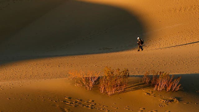

Death Valley visitor suffers third-degree burns on feet amid extreme heat
The Death Valley tourist burned his feet walking barefoot on the popular Mesquite Flat Sand Dunes, where temperatures exceeded 123 degrees F, park rangers said.
The Death Valley tourist burned his feet walking barefoot on the popular Mesquite Flat Sand Dunes, where temperatures exceeded 123 degrees F, park rangers said.
Weather Webcast with Stephanie Barichello
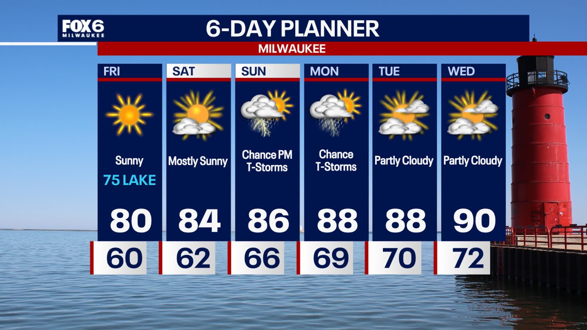
A few more quiet days ahead then humidity rises Sunday and storms return. Another chance for storms on Monday. Hot and humid much of next week.
A few more quiet days ahead then humidity rises Sunday and storms return. Another chance for storms on Monday. Hot and humid much of next week.
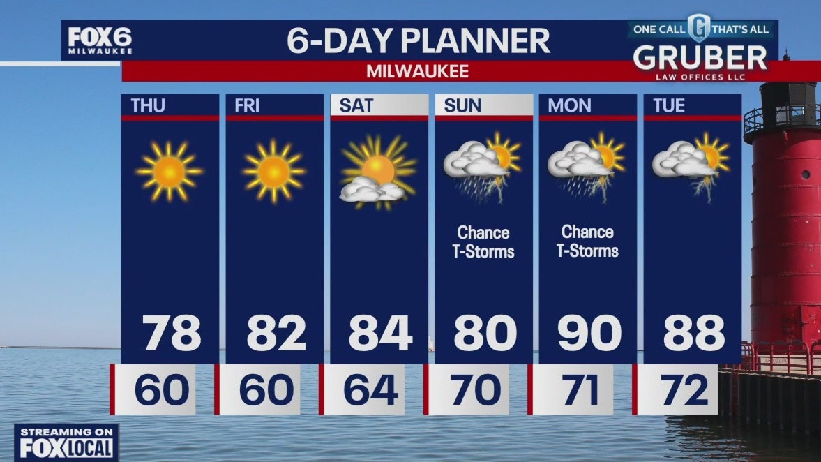
Weather webcast with Rob Haswell
High pressure dominates our forecast today with sunny conditions but cooler than average temperatures. Highs will be in the mid to upper 70s inland and low 70s lakeside again today.
High pressure dominates our forecast today with sunny conditions but cooler than average temperatures. Highs will be in the mid to upper 70s inland and low 70s lakeside again today.
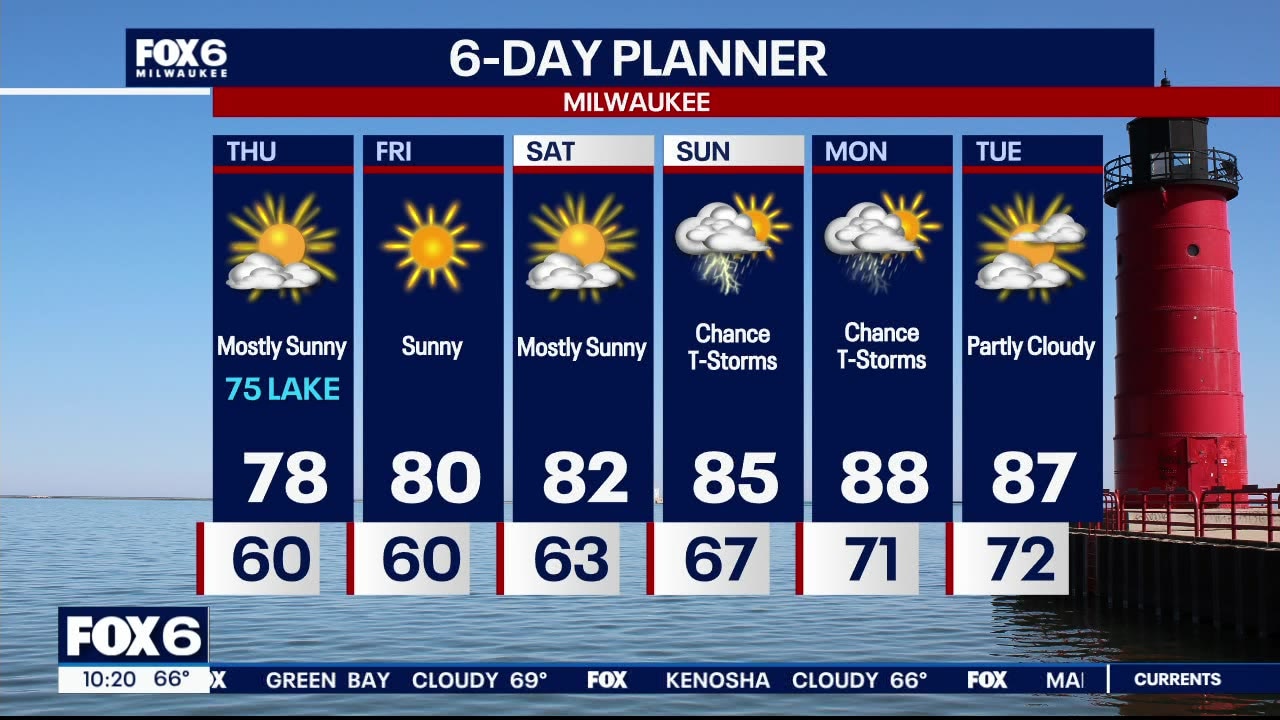
Weather webcast with Lisa Michaels
Clearing clouds tonight with low temperatures in the 50s to around 60. Possible fog inland by Thursday morning. Quiet, pleasant, and sunny through Saturday with high temperatures in the 70s and low 80s. A more active period of rain/storms arrives Sunday into Monday. Hot and humid condition return Sunday into Monday. That pattern could hold through all of next week.
Clearing clouds tonight with low temperatures in the 50s to around 60. Possible fog inland by Thursday morning. Quiet, pleasant, and sunny through Saturday with high temperatures in the 70s and low 80s. A more active period of rain/storms arrives Sunday into Monday. Hot and humid condition return Sunday into Monday. That pattern could hold through all of next week.


Monday was the hottest ever recorded day on Earth, data shows
Monday’s scorching temperatures were yet another heat record broken in the past couple of years.
Monday’s scorching temperatures were yet another heat record broken in the past couple of years.