

Weather Webcast with Tom Wachs
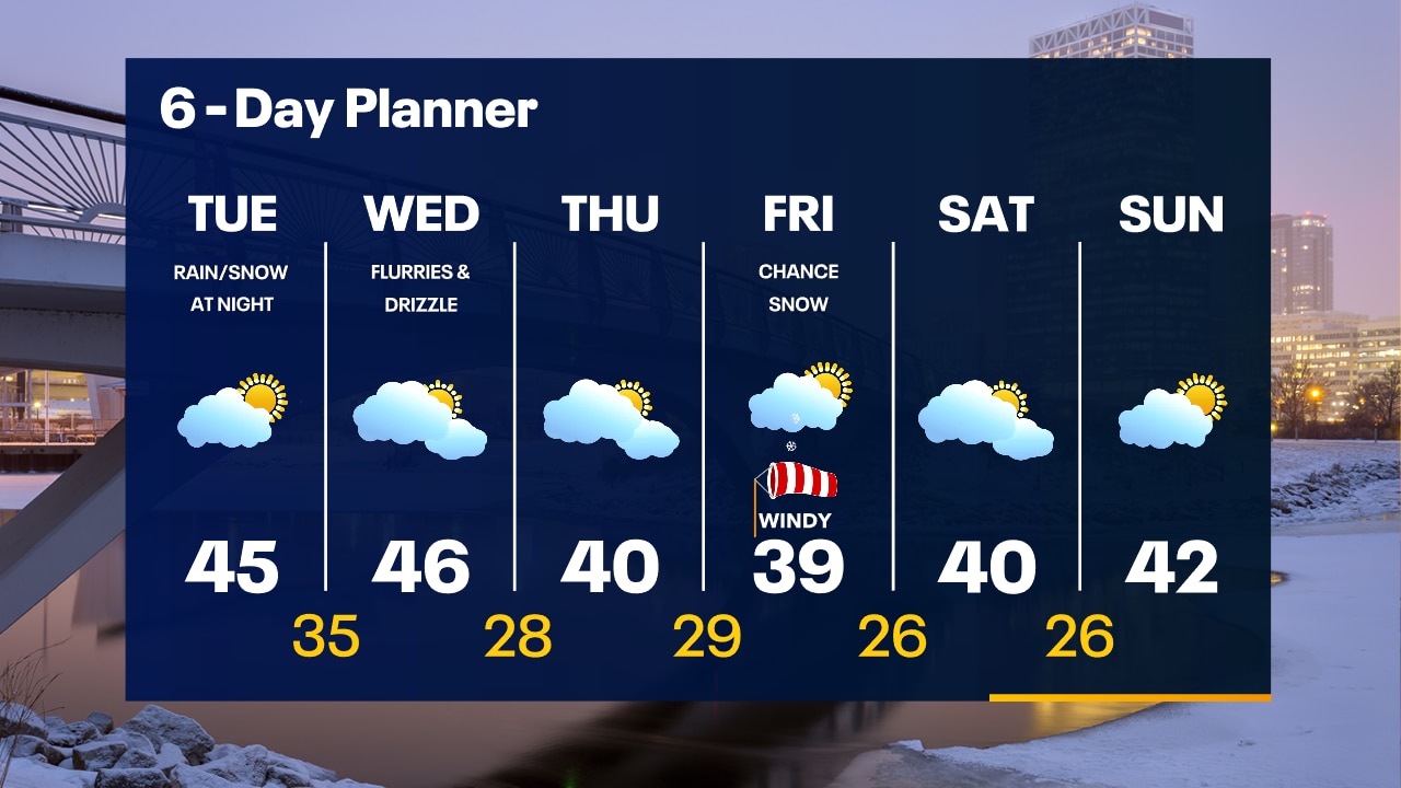
Refreeze is likely overnight, especially inland as temperatures drop below freezing. Watch out for patchy slick spots on parking lots, driveways, sidewalks, etc.
Refreeze is likely overnight, especially inland as temperatures drop below freezing. Watch out for patchy slick spots on parking lots, driveways, sidewalks, etc.
Weather Webcast with Tom Wachs
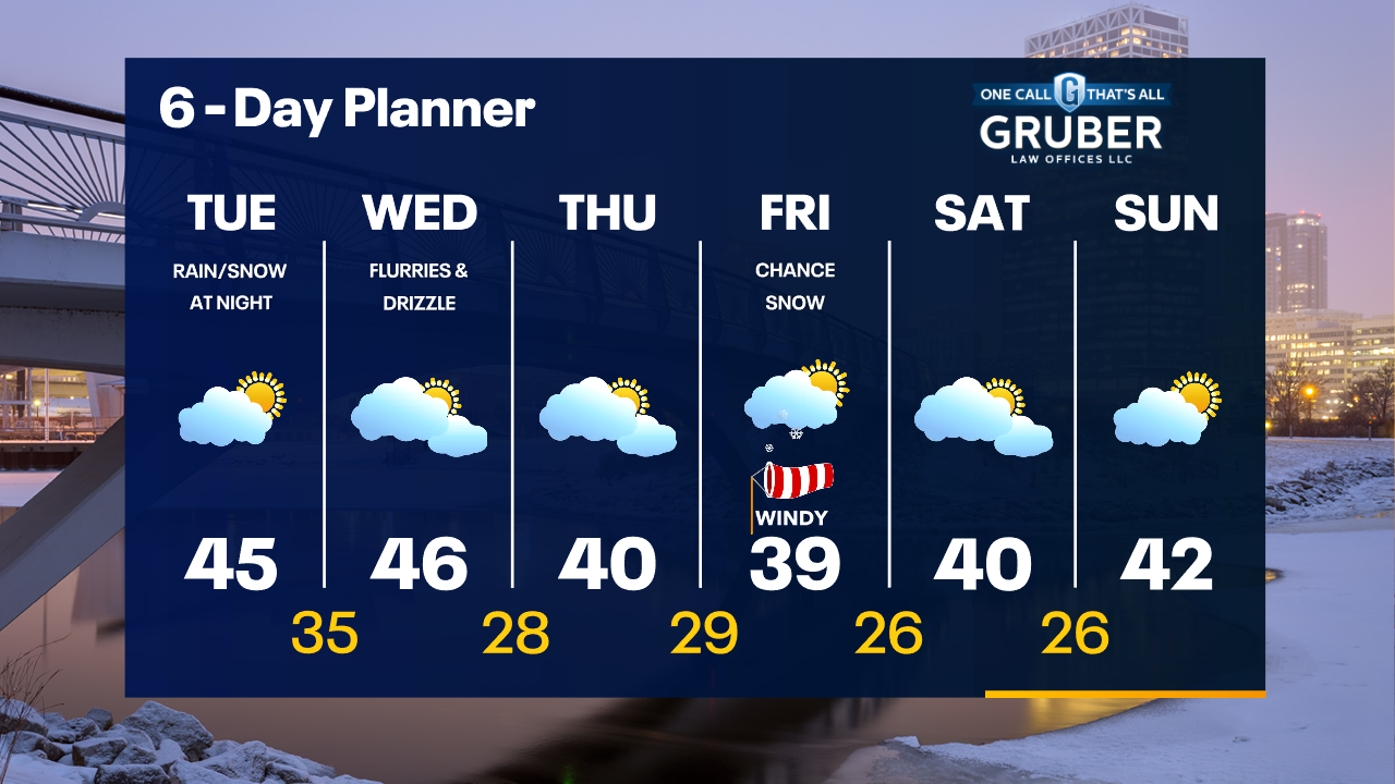
Precipitation is ending but refreeze is likely tonight, especially away from the lake. Watch out for slick spots tonight into the morning.
Precipitation is ending but refreeze is likely tonight, especially away from the lake. Watch out for slick spots tonight into the morning.

Weather Webcast with Meteorologist Stephanie Barichello
Scattered rain showers continue this afternoon but will be lighter than earlier this morning. Drying out tonight and tomorrow, then a quick round of rain/snow mix Tuesday night into Wednesday. Cooler the rest of the week.
Scattered rain showers continue this afternoon but will be lighter than earlier this morning. Drying out tonight and tomorrow, then a quick round of rain/snow mix Tuesday night into Wednesday. Cooler the rest of the week.

Weather webcast with Rob Haswell
A strong low passes from Iowa to Michigan today and tonight with rain likely and a chance of thunderstorms. There is a risk for freezing rain north of our area. A Winter Weather Advisory has been issued for Fond du Lac and Sheboygan counties. Temperatures will be on the milder side today - in the mid 40s - and will stay mild through midweek. We cool back to more seasonal temperatures by Thursday.
A strong low passes from Iowa to Michigan today and tonight with rain likely and a chance of thunderstorms. There is a risk for freezing rain north of our area. A Winter Weather Advisory has been issued for Fond du Lac and Sheboygan counties. Temperatures will be on the milder side today - in the mid 40s - and will stay mild through midweek. We cool back to more seasonal temperatures by Thursday.
Weather Webcast with Tom Wachs
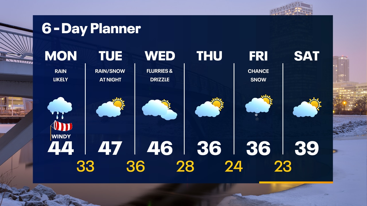
Rain moves in after 5am Monday. It will be a very rainy and windy morning. Over 1" of rain possible with wind gusts as high as 40mph. Lighter rain and wind during the afternoon.
Rain moves in after 5am Monday. It will be a very rainy and windy morning. Over 1" of rain possible with wind gusts as high as 40mph. Lighter rain and wind during the afternoon.
Weather Webcast with Tom Wachs
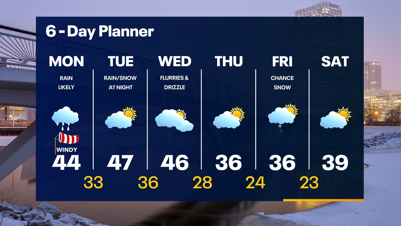
Heavy rain on the way Monday morning. Some freezing rain possible in Fond du Lac and Sheboygan counties. Windy with over 1" of rain expected by early afternoon.
Heavy rain on the way Monday morning. Some freezing rain possible in Fond du Lac and Sheboygan counties. Windy with over 1" of rain expected by early afternoon.
Weather Webcast with Meteorologist Lisa Michaels
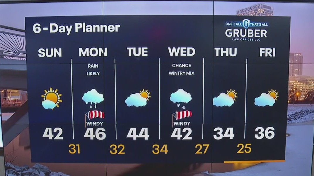
Mainly sunny Sunday with highs in the upper 30s to low 40s. Heading into Monday, a system will bring a wintry mix initially with heavy rain and a few rumbles of thunder during the morning. Lingering light snow north by the afternoon.
Mainly sunny Sunday with highs in the upper 30s to low 40s. Heading into Monday, a system will bring a wintry mix initially with heavy rain and a few rumbles of thunder during the morning. Lingering light snow north by the afternoon.

Weather Webcast with Meteorologist Eric Manges
Get ready for a beautiful Sunday then a soaker of a Monday
Get ready for a beautiful Sunday then a soaker of a Monday
Weather Webcast with Meteorologist Lisa Michaels
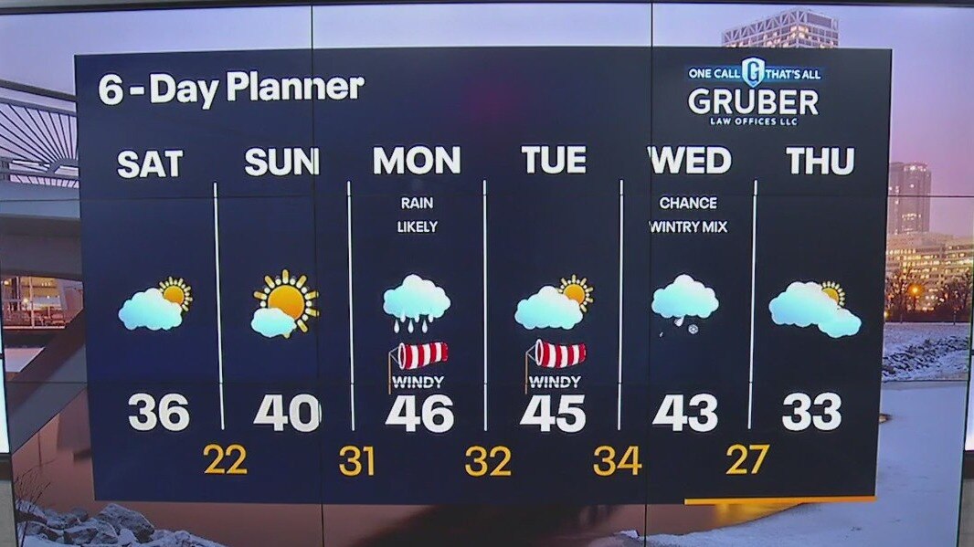
Cloud cover around during the morning and will gradually decrease through the day giving us sunshine by the afternoon. Highs in the low to mid 30s. Warmer temperatures expected on Sunday in the upper 30s to low 40s with added sunshine.
Cloud cover around during the morning and will gradually decrease through the day giving us sunshine by the afternoon. Highs in the low to mid 30s. Warmer temperatures expected on Sunday in the upper 30s to low 40s with added sunshine.
Weather Webcast with Meteorologist Eric Manges
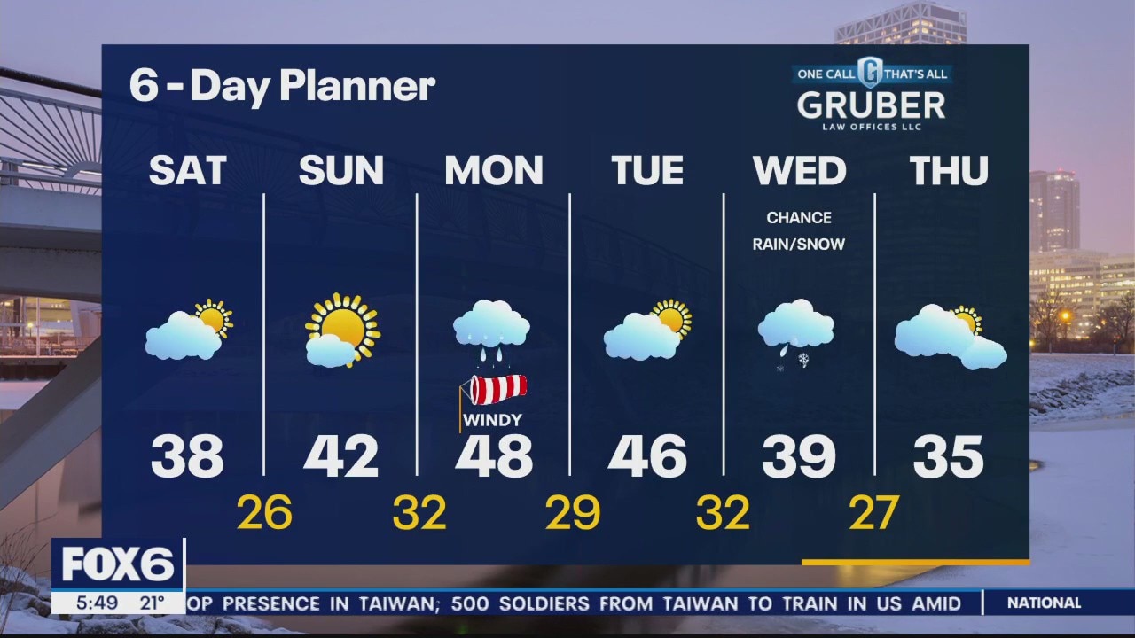
FOX6 News at 5 offers the day's news, weather, and sports in southeast Wisconsin, the nation, and the world.
FOX6 News at 5 offers the day's news, weather, and sports in southeast Wisconsin, the nation, and the world.
Weather webcast with Rob Haswell
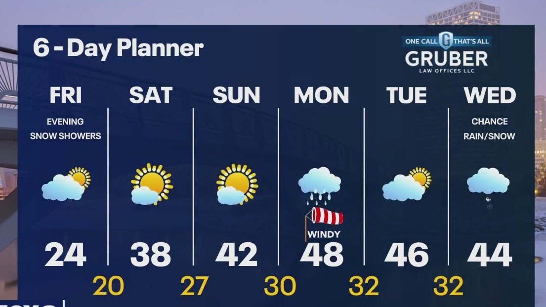
High pressure builds across our area today giving us a chilly but sunny start to our day. A slight disturbance moves into our area this evening with a few snow showers possible. As the high moves farther east, we warm up and highs go from the 20s today to the 30s on Saturday and into the 40s on Sunday! A strong low moves our way on Monday with quite a bit of rain possible. We should warm well into the 40s early next week. We dry up Tuesday and Wednesday.
High pressure builds across our area today giving us a chilly but sunny start to our day. A slight disturbance moves into our area this evening with a few snow showers possible. As the high moves farther east, we warm up and highs go from the 20s today to the 30s on Saturday and into the 40s on Sunday! A strong low moves our way on Monday with quite a bit of rain possible. We should warm well into the 40s early next week. We dry up Tuesday and Wednesday.

Weather Webcast with Tom Wachs
Light snow and gusty winds tapering off overnight. Temperatures drop into the single digits and low teens by morning. Mostly cloudy and cold on Friday with highs in the low 20s. Light snow Friday night.
Light snow and gusty winds tapering off overnight. Temperatures drop into the single digits and low teens by morning. Mostly cloudy and cold on Friday with highs in the low 20s. Light snow Friday night.

Weather Webcast with Tom Wachs
Light snow showers ending with the wind tapering off tonight. Temperatures will really drop overnight into the single digits and low teens. Wind chills will be around 0 by morning.
Light snow showers ending with the wind tapering off tonight. Temperatures will really drop overnight into the single digits and low teens. Wind chills will be around 0 by morning.
Weather Webcast With Lisa Michaels
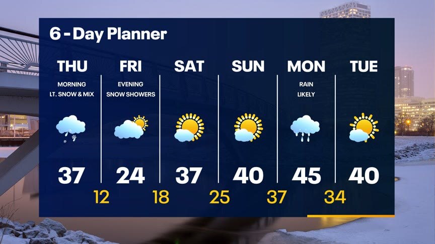
Winter Storm Warning for Ozaukee, Washington, Dodge, Sheboygan and Fond du Lac counties until Noon. Minor precipitation could fall during the afternoon, but no real additional impacts expected. Temperatures will reach the mid to upper 30s today but fall to the low double digits tonight. Clearing clouds will help temperatures drop into the single digits and teens by Friday morning. The sun returns Friday but with cold highs in the 20s. A few light snow showers are possible Friday night. We warm this weekend with rain likely by Monday.
Winter Storm Warning for Ozaukee, Washington, Dodge, Sheboygan and Fond du Lac counties until Noon. Minor precipitation could fall during the afternoon, but no real additional impacts expected. Temperatures will reach the mid to upper 30s today but fall to the low double digits tonight. Clearing clouds will help temperatures drop into the single digits and teens by Friday morning. The sun returns Friday but with cold highs in the 20s. A few light snow showers are possible Friday night. We warm this weekend with rain likely by Monday.
Weather webcast with Rob Haswell
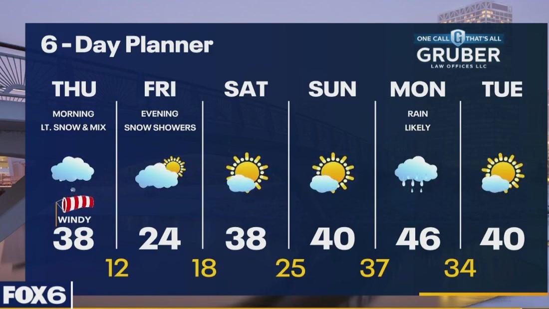
Winter Storm Warning for Ozaukee, Washington, Dodge, Sheboygan and Fond du Lac counties until Noon. A Winter Weather Advisory for Milwaukee, Waukesha, Jefferson, Walworth, Racine and Kenosha counties continues until 9am. Light snow showers and patchy freezing drizzle is winding down this morning and we should dry up by the afternoon. Temperatures will reach the mid to upper 30s today but fall to the low double digits tonight.
Winter Storm Warning for Ozaukee, Washington, Dodge, Sheboygan and Fond du Lac counties until Noon. A Winter Weather Advisory for Milwaukee, Waukesha, Jefferson, Walworth, Racine and Kenosha counties continues until 9am. Light snow showers and patchy freezing drizzle is winding down this morning and we should dry up by the afternoon. Temperatures will reach the mid to upper 30s today but fall to the low double digits tonight.
Weather Webcast with Tom Wachs
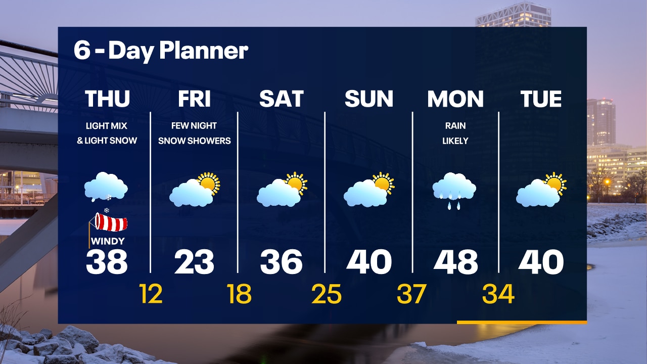
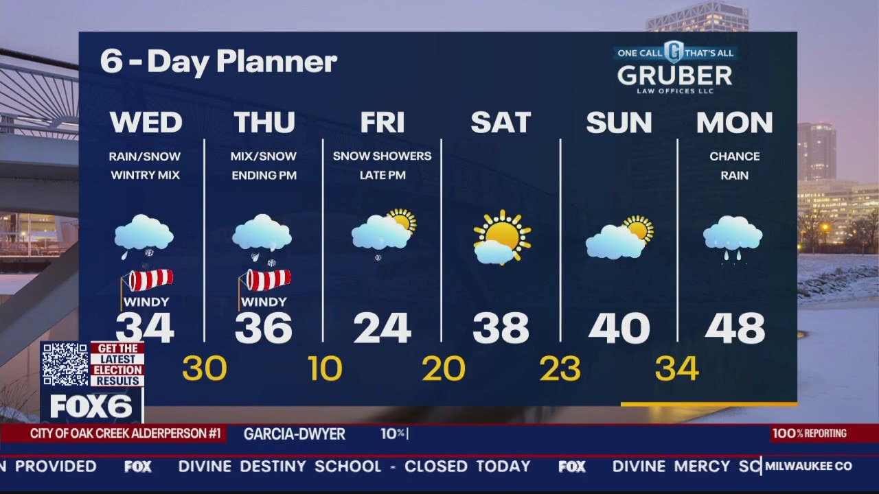
The wintry mix of precipitation will gradually taper off overnight. Watch out for slick roads. A few icy patches are possible Thursday AM otherwise a few scattered rain/snow showers. Much better Thursday than Wednesday.
The wintry mix of precipitation will gradually taper off overnight. Watch out for slick roads. A few icy patches are possible Thursday AM otherwise a few scattered rain/snow showers. Much better Thursday than Wednesday.
Weather Webcast with Tom Wachs
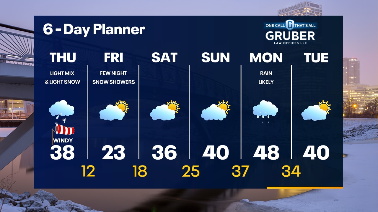
Snow, sleet and freezing rain will continue throughout the evening. The precipitation will get lighter overnight. Thursday will not be as bad of a day as Wednesday.
Snow, sleet and freezing rain will continue throughout the evening. The precipitation will get lighter overnight. Thursday will not be as bad of a day as Wednesday.
Weather Webcast with Meteorologist Eric Manges
FOX6 News at 11 offers the day's news, weather, and sports in southeast Wisconsin, the nation, and the world.
FOX6 News at 11 offers the day's news, weather, and sports in southeast Wisconsin, the nation, and the world.
Weather webcast with Rob Haswell
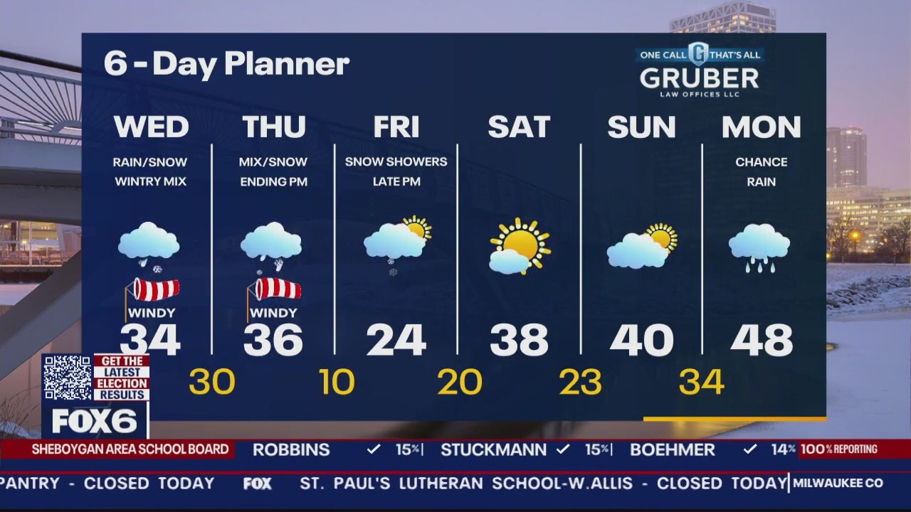
Winter Storm Warning 6am Wed. to Noon Thu. For Milwaukee, Waukesha, Jefferson, Dodge, Washington, Ozaukee, Sheboygan and Fond du Lac Cos. Ice Storm Warning Racine, Kenosha and Walworth Co. from 6am Wed. to Noon Thu. A strong low moves from Missouri today into Michigan by tomorrow afternoon. It will bring rain, snow, sleet and freezing rain to our area over the next 25-36 hours. Areas north of a line from Beaver Dam to Port Washington could see 6 inches of snow or more. South of that line to a line from Fort Atkinson to Oak Creek can expect a wintry mix and snow. South of that line will be mostly sleet and freezing rain with up to half an inch of ice possible.
Winter Storm Warning 6am Wed. to Noon Thu. For Milwaukee, Waukesha, Jefferson, Dodge, Washington, Ozaukee, Sheboygan and Fond du Lac Cos. Ice Storm Warning Racine, Kenosha and Walworth Co. from 6am Wed. to Noon Thu. A strong low moves from Missouri today into Michigan by tomorrow afternoon. It will bring rain, snow, sleet and freezing rain to our area over the next 25-36 hours. Areas north of a line from Beaver Dam to Port Washington could see 6 inches of snow or more. South of that line to a line from Fort Atkinson to Oak Creek can expect a wintry mix and snow. South of that line will be mostly sleet and freezing rain with up to half an inch of ice possible.
Weather Webcast with Tom Wachs
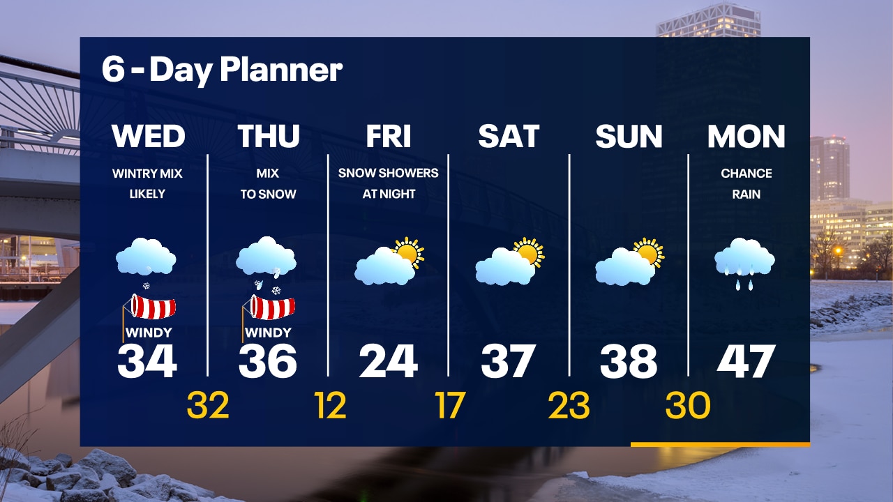
Winter Storm and Ice Storm Warnings start at 9am Wednesday and run until Noon Thursday. It will be extremely slick across SE WI starting late morning and especially by Wednesday afternoon and evening.
Winter Storm and Ice Storm Warnings start at 9am Wednesday and run until Noon Thursday. It will be extremely slick across SE WI starting late morning and especially by Wednesday afternoon and evening.