

Weather webcast with Rob Haswell
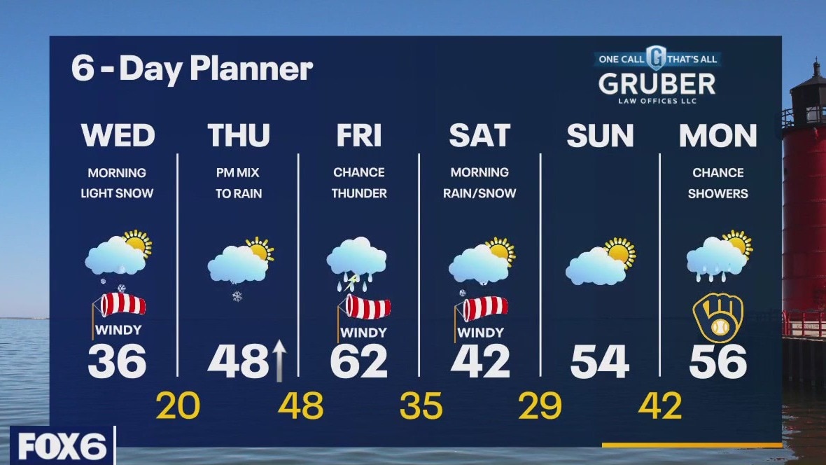
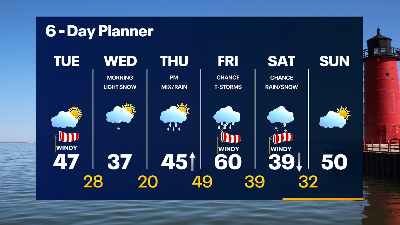
A cold front clears our area early this morning with a quick burst of snow. High pressure builds in behind that front and we clear to full sun for the afternoon. Highs today will be in the mid 30s and temperatures fall to the teens and low 20s overnight. A warmup begins tomorrow with high temperatures for the day likely occurring just before midnight. We continue to warm overnight and get into the 60s by Friday. A brief period of wintry mix is possible Thursday before we warm enough for all rain into Friday. There may be enough instability for strong to severe storms on Friday.
A cold front clears our area early this morning with a quick burst of snow. High pressure builds in behind that front and we clear to full sun for the afternoon. Highs today will be in the mid 30s and temperatures fall to the teens and low 20s overnight. A warmup begins tomorrow with high temperatures for the day likely occurring just before midnight. We continue to warm overnight and get into the 60s by Friday. A brief period of wintry mix is possible Thursday before we warm enough for all rain into Friday. There may be enough instability for strong to severe storms on Friday.
Weather Webcast with Tom Wachs
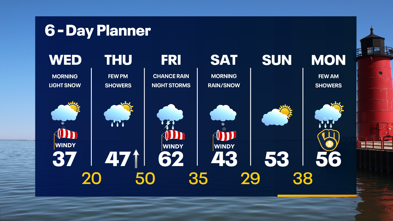
A quick band of snow will move through Wednesday morning which could slow down the morning commute. Low visibility and slowdowns are likely. Abundant sunshine by afternoon.
A quick band of snow will move through Wednesday morning which could slow down the morning commute. Low visibility and slowdowns are likely. Abundant sunshine by afternoon.
Weather Webcast with Tom Wachs
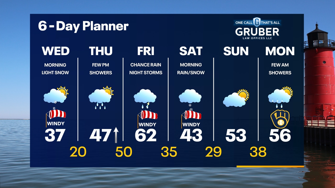
Quiet tonight with a quick burst of snow Wednesday morning during the morning commute. Reduced visibility likely. It will move out quickly with sunny skies by noon.
Quiet tonight with a quick burst of snow Wednesday morning during the morning commute. Reduced visibility likely. It will move out quickly with sunny skies by noon.

Weather Webcast with Meteorologist Stephanie Barichello
More sunshine this afternoon then light snow moves through Wednesday morning. Up to 1" of accumulation possible. Rain Thursday night into Friday with a few thunderstorms, as well.
More sunshine this afternoon then light snow moves through Wednesday morning. Up to 1" of accumulation possible. Rain Thursday night into Friday with a few thunderstorms, as well.
Weather webcast with Rob Haswell
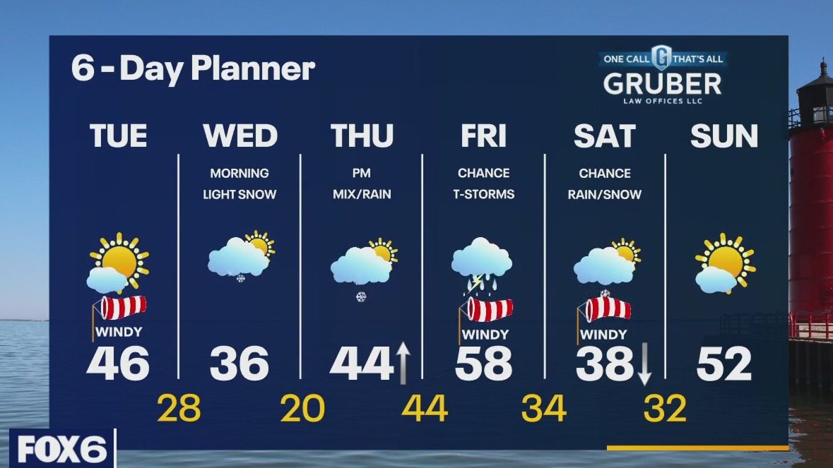
Partly cloudy this morning but clearing by this afternoon. We should warm into the mid 40s today. Overnight a low moves through with light snow likely. Around 1" is likely in most areas but the timing of this snow may cause issues as it will arrive during the morning commute. We clear out again Wednesday afternoon but rain and snow return early Thursday. As we warm up on Thursday we transition to all rain. Rain continues into Friday with a chance for thunderstorms. Strong storms are possible.
Partly cloudy this morning but clearing by this afternoon. We should warm into the mid 40s today. Overnight a low moves through with light snow likely. Around 1" is likely in most areas but the timing of this snow may cause issues as it will arrive during the morning commute. We clear out again Wednesday afternoon but rain and snow return early Thursday. As we warm up on Thursday we transition to all rain. Rain continues into Friday with a chance for thunderstorms. Strong storms are possible.
Weather Webcast with Tom Wachs
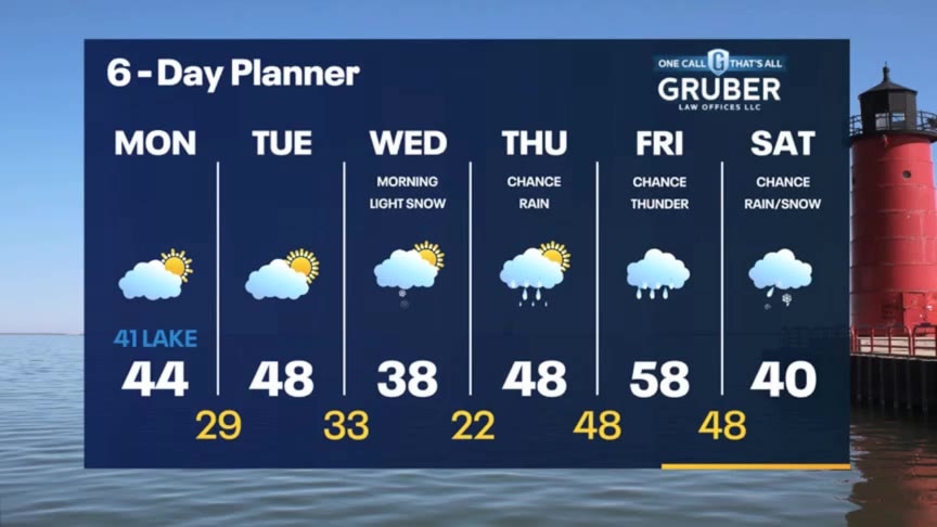
Mostly clear overnight with temperatures in the 20s by morning. Refreeze of melted snow is possible in spots. Partly sunny and mild on Tuesday with highs in the 40s.
Mostly clear overnight with temperatures in the 20s by morning. Refreeze of melted snow is possible in spots. Partly sunny and mild on Tuesday with highs in the 40s.

Weather Webcast with Tom Wachs
Mostly clear tonight with temperatures dropping through the 30s and into the 20s overnight. Partly sunny and quiet on Tuesday with highs in the 40s.
Mostly clear tonight with temperatures dropping through the 30s and into the 20s overnight. Partly sunny and quiet on Tuesday with highs in the 40s.
Weather Webcast with Meteorologist Stephanie Barichello
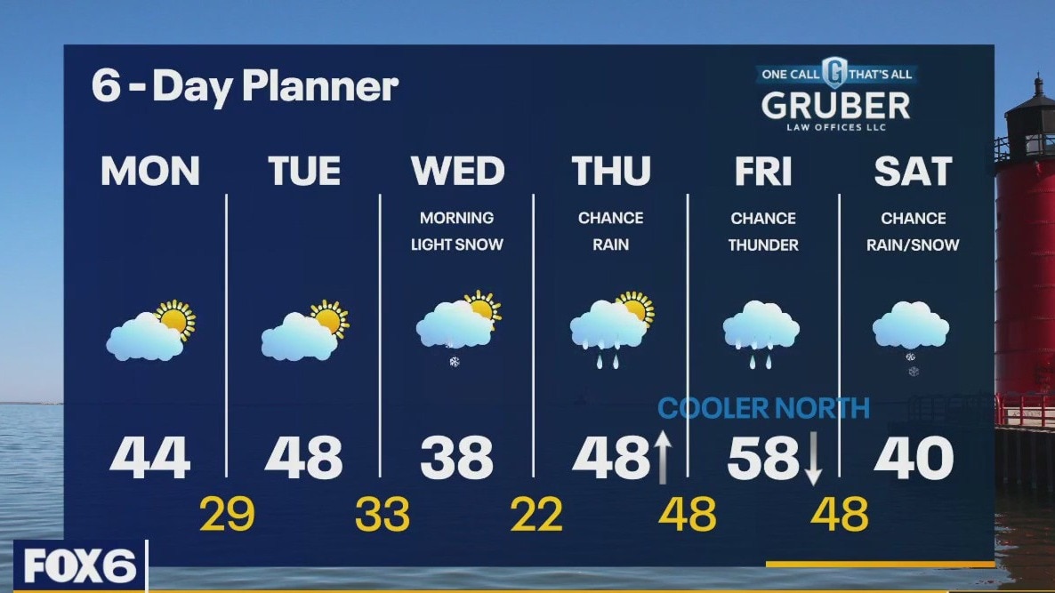
A calm start to the work week then a round of light snow will impact Wednesday morning's commute. Rain returns later Thursday into Friday before changing back to brief wintry mix Saturday morning.
A calm start to the work week then a round of light snow will impact Wednesday morning's commute. Rain returns later Thursday into Friday before changing back to brief wintry mix Saturday morning.
Weather webcast with Rob Haswell
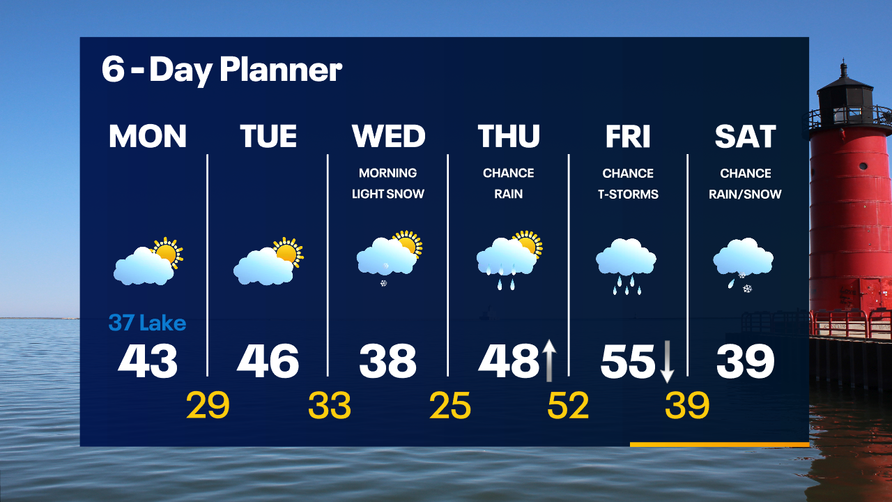
Ahead of a fairly weak cold front today we warm slightly into the low to mid 40s with partly sunny conditions. A light northeast wind will keep things a bit cooler near Lake Michigan. We stay dry again Tuesday, but a disturbance arrives early Wednesday with some very light snow. A warmup arrives later this week with temperatures getting well into the 50s. That warm up comes along with some rain.
Ahead of a fairly weak cold front today we warm slightly into the low to mid 40s with partly sunny conditions. A light northeast wind will keep things a bit cooler near Lake Michigan. We stay dry again Tuesday, but a disturbance arrives early Wednesday with some very light snow. A warmup arrives later this week with temperatures getting well into the 50s. That warm up comes along with some rain.
Weather Webcast with Tom Wachs
Clearing skies overnight with temperatures dropping into the upper 20s to low 30s by sunrise. Watch out for patchy refreeze. Partly to mostly sunny and quiet on Monday with highs in the low 40s inland, upper 30s near the lake.
Clearing skies overnight with temperatures dropping into the upper 20s to low 30s by sunrise. Watch out for patchy refreeze. Partly to mostly sunny and quiet on Monday with highs in the low 40s inland, upper 30s near the lake.

Weather Webcast with Tom Wachs
Rain/snow showers will move out of the area around midnight. Clearing skies overnight with temperatures in the upper 20s to low 30s by sunrise. Party sunny on Monday with highs in the upper 30s to low 40s.
Rain/snow showers will move out of the area around midnight. Clearing skies overnight with temperatures in the upper 20s to low 30s by sunrise. Party sunny on Monday with highs in the upper 30s to low 40s.

Weather Webcast with Meteorologist Lisa Michaels
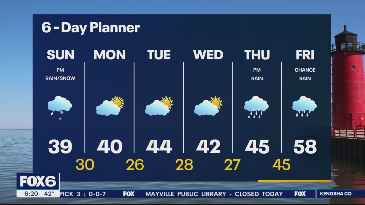
With temperatures below freezing this morning, slick spots on roads are possible. Starting off with sunshine on Sunday and transitioning to more cloudy skies this afternoon with a light chance of rain/snow into tonight.
With temperatures below freezing this morning, slick spots on roads are possible. Starting off with sunshine on Sunday and transitioning to more cloudy skies this afternoon with a light chance of rain/snow into tonight.
Weather Webcast with Meteorologist Eric Manges
Another big snow for Wisconsin just adding to our unique March this year
Another big snow for Wisconsin just adding to our unique March this year

Weather Webcast with Meteorologist Lisa Michaels
Winter storm warning and winter weather advisory across southeast Wisconsin until 4PM. Wet and heavy snow will continue through Saturday. 5-8" is possible in many locations. Most accumulation on elevated and grassy surfaces.
Winter storm warning and winter weather advisory across southeast Wisconsin until 4PM. Wet and heavy snow will continue through Saturday. 5-8" is possible in many locations. Most accumulation on elevated and grassy surfaces.

Weather Webcast with Meteorologist Eric Manges
Impactful snow tonight of widespread 4-8" possible with higher totals SE. Winter Storm Warning until 1pm Saturday.
Impactful snow tonight of widespread 4-8" possible with higher totals SE. Winter Storm Warning until 1pm Saturday.
Weather Webcast With Lisa Michaels
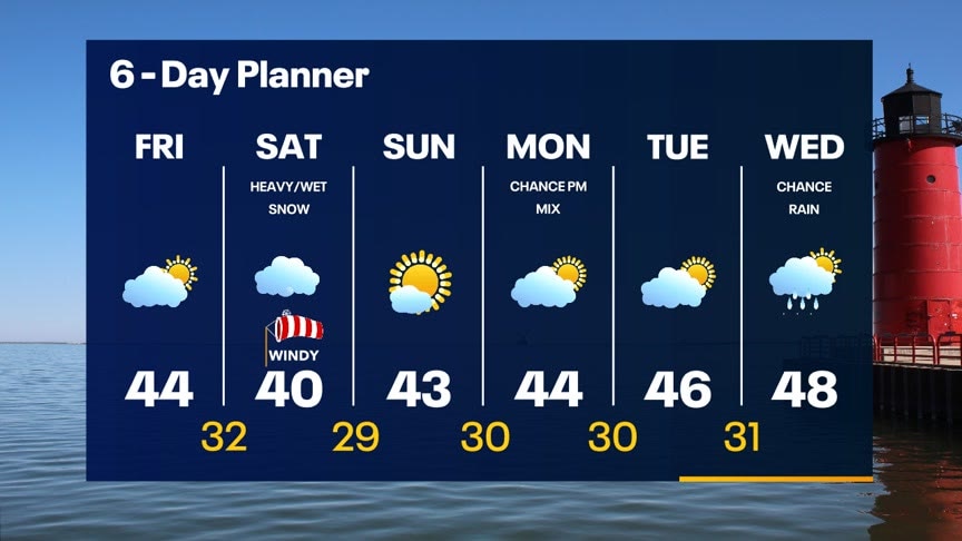
A low pressure will move northeast across Missouri and Illinois today into Saturday. This will bring the chance for heavy/wet snow Saturday morning into the early afternoon. Gusty winds up to 35mph through Saturday will reduce visibility when snow falls. Winter weather advisory begins 4AM-1PM Saturday. 4-8 inches possible for some areas. Sunshine and the low to mid 40s back by Sunday.
A low pressure will move northeast across Missouri and Illinois today into Saturday. This will bring the chance for heavy/wet snow Saturday morning into the early afternoon. Gusty winds up to 35mph through Saturday will reduce visibility when snow falls. Winter weather advisory begins 4AM-1PM Saturday. 4-8 inches possible for some areas. Sunshine and the low to mid 40s back by Sunday.
Weather webcast with Rob Haswell
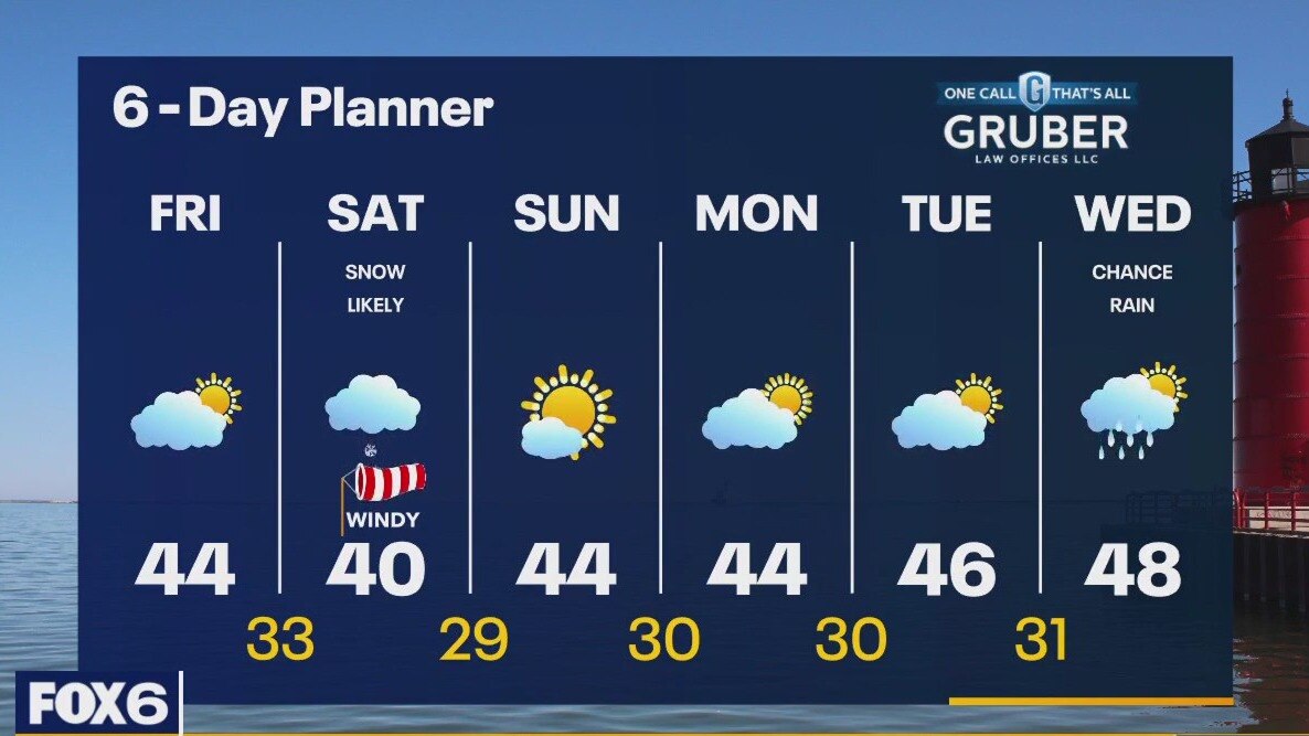
A low developing in Texas today will move across Illinois and into Michigan tonight and tomorrow morning. Ahead of that low today we can expect increasingly cloudy conditions with highs in the low to mid 40s. As the low gets closer overnight, we will see a wintry mix or rain changing to a heavy snow. Steady moderate to heavy snow is likely through early afternoon on Saturday. A Winter Weather Advisory begins at 4am Saturday. 3-6 inches of snow are possible in some areas.
A low developing in Texas today will move across Illinois and into Michigan tonight and tomorrow morning. Ahead of that low today we can expect increasingly cloudy conditions with highs in the low to mid 40s. As the low gets closer overnight, we will see a wintry mix or rain changing to a heavy snow. Steady moderate to heavy snow is likely through early afternoon on Saturday. A Winter Weather Advisory begins at 4am Saturday. 3-6 inches of snow are possible in some areas.
Weather Webcast with Tom Wachs
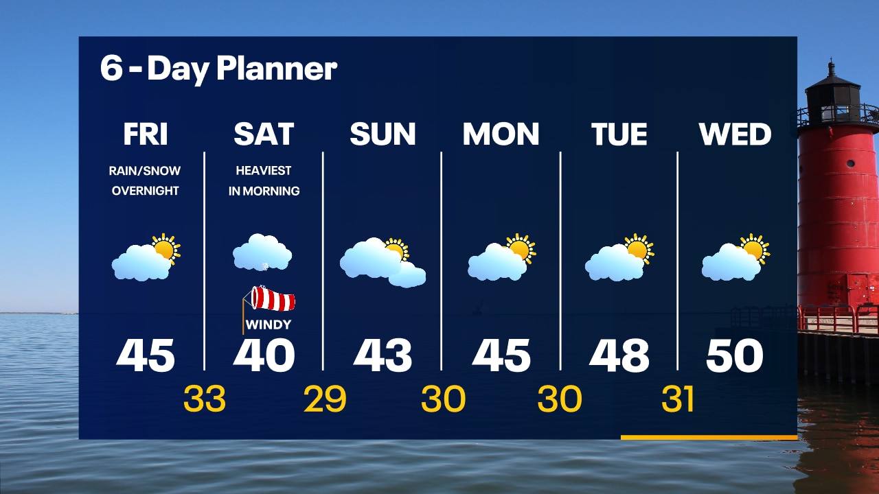
Mostly clear overnight with temperatures dropping into the 20s. Partly sunny on Friday with highs in the mid-40s. Snow moves in early Saturday morning with several inches likely.
Mostly clear overnight with temperatures dropping into the 20s. Partly sunny on Friday with highs in the mid-40s. Snow moves in early Saturday morning with several inches likely.

Weather Webcast with Tom Wachs
Quiet tonight and again on Friday. Accumulating snow moves in overnight Friday night into Saturday. The heaviest will be Saturday morning.
Quiet tonight and again on Friday. Accumulating snow moves in overnight Friday night into Saturday. The heaviest will be Saturday morning.
Weather Webcast with Meteorologist Stephanie Barichello
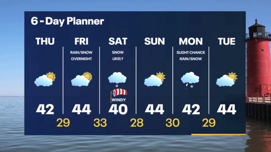
Decreasing clouds this afternoon then more sunshine on Friday. Snow is back in the forecast Saturday, and it looks likely that it'll accumulate. Better by Sunday then another round of wintry mix Monday.
Decreasing clouds this afternoon then more sunshine on Friday. Snow is back in the forecast Saturday, and it looks likely that it'll accumulate. Better by Sunday then another round of wintry mix Monday.