

Southeast Wisconsin winter storm warning; temps plummet

MILWAUKEE - A Winter Storm Warning has been posted for all of southeast Wisconsin from now through 6 a.m. Saturday, Dec. 24.
Monitor the FOX6 Weather Experts forecast for frequent updates.
Forecast breakdown
Timeframe: Snow will continue throughout Thursday afternoon and evening, tapering off later Thursday night. Expect wind gusts Thursday evening to be between 30-40mph, which could reduce visibility at times when combined with the falling snow. Blowing snow will then be the primary hazard Thursday night and into the day Friday. Temperatures will fall into the single digits by Thursday afternoon and will then fall below 0 by Friday morning. Wind chills will fall into the 20s and 30s below 0 by Friday morning. Daytime wind chills Friday will be around -20°, daytime wind chills Saturday around -15°.
iAmounts: The snow totals have come down in spots since prior forecasts, but this does not change the blizzard-like potential. Inland communities picked up 1-2" of snow Thursday morning, less lakeside. Most of SE WI will end with a total of 2-5" by Thursday night. Even after the snow ends blowing ground snow will stay an issue.
Impacts: Travel will be messy Thursday night through Friday. The strong winds continue on Saturday with blowing ground snow. Bitter cold air spills in Thursday afternoon with wind chills as low as -35 Friday morning and -20 during the day on Friday. Wind chills -15 to -35 on Saturday. Power outages are very possible because of west-northwesterly wind gusts between 35-55mph.
Snow Type: This will be a fluffy, sand lake snow due to how cold temperatures will be.
A blizzard is defined as heavy snow with wind gusts of 35 mph or greater and reduced visibility to 0.25 mi. or less for three hours or more. We will be close to blizzard status at times Thursday evening. The last Blizzard Warning in SE WI (Walworth, Racine & Kenosha Co.) was in 2018. The last Blizzard Warning for Milwaukee County was 2011.
The wind will really pick up Thursday night into Friday creating whiteout conditions at times. Expect travel delays both by air and car on Thursday evening and Friday. If you have plans to travel by air, stay up to date with your airline. It is possible to see power outages and interstate closers in parts of the upper Midwest Thursday night and Friday.
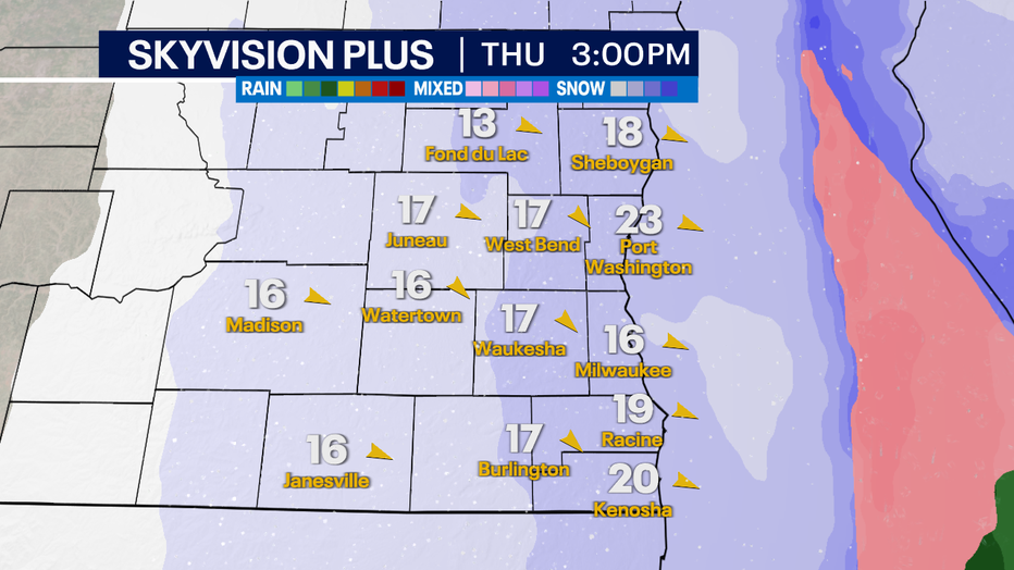
Forecast for 3pm Thursday
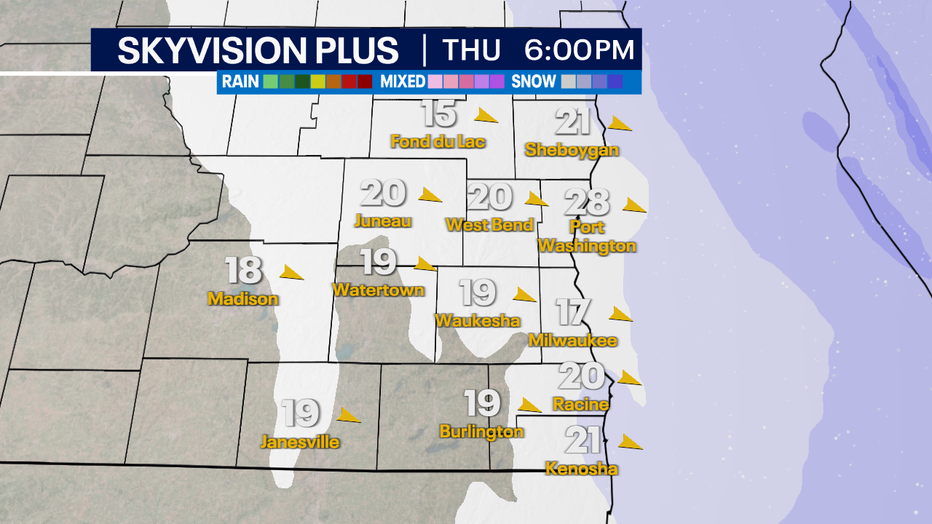
Forecast for 6pm Thursday. Snow winding down.
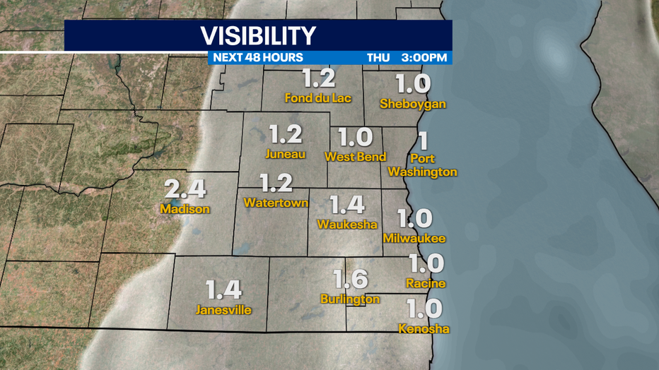
Thursday Afternoon Visibility Forecast
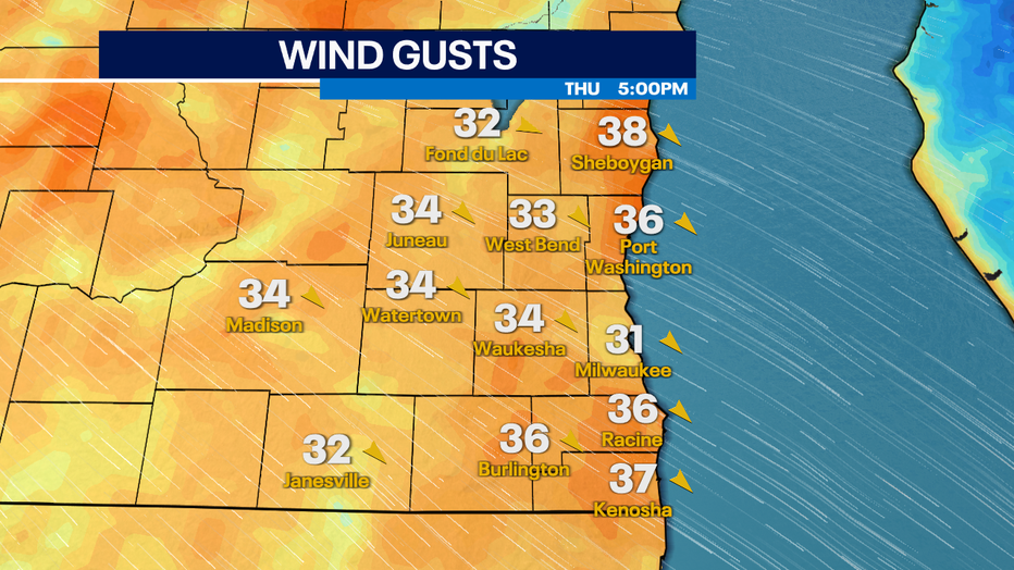
Thursday Evening Wind Gust Forecast
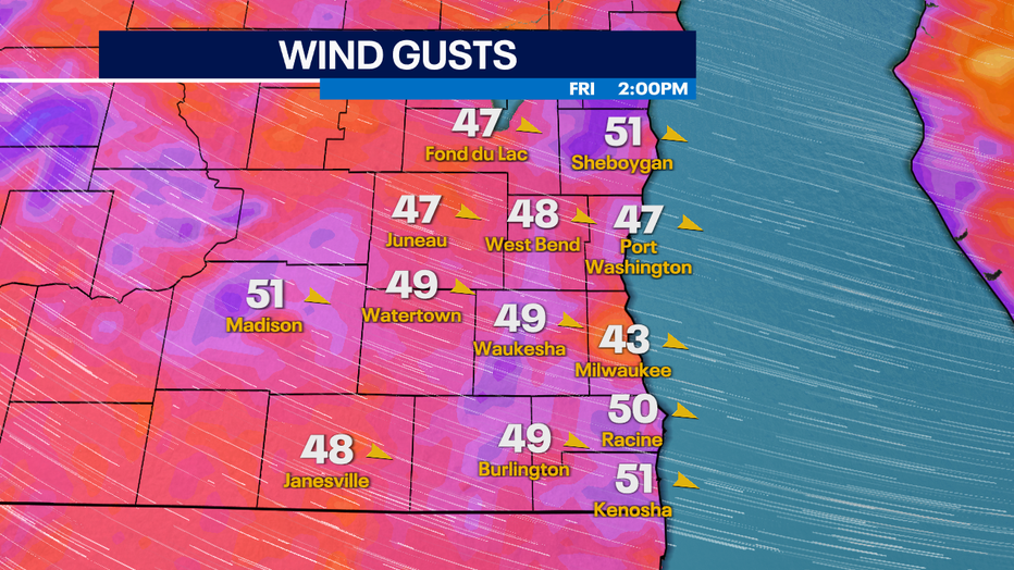
Friday Afternoon Wind Gust Forecast
Stay weather aware
Meanwhile, FOX6Now.com offers a variety of extremely useful weather tools to help you navigate the stormy season. They include the following:
FOX6 Storm Center app
FOX6 News app
FOX Weather app
MAPS AND RADAR
We have a host of maps and radars on the FOX6 Weather page that are updating regularly — to provide you the most accurate assessment of the weather. From a county-by-county view to the Midwest regional radar and a national view — it’s all there.
SCHOOL AND BUSINESS CLOSINGS
When the weather gets a little dicey, schools and businesses may shut down. Monitor the latest list of closings, cancellations, and delays reported in southeast Wisconsin.

FOX6 WEATHER IN SOCIAL MEDIA
- CLICK HERE to "Like" the FOX6 Weather Team on Facebook
- CLICK HERE to "Like" Rob Haswell on Facebook
- CLICK HERE to "Like" Tom Wachs on Facebook
- CLICK HERE to "Like" Stephanie Barichello on Facebook
- CLICK HERE to "Like" Eric Manges on Facebook
- CLICK HERE to "Like" Lisa Michaels on Facebook
- CLICK HERE to "Follow" the FOX6 Weather Team on Twitter
- CLICK HERE to "Follow" Rob Haswell on Twitter
- CLICK HERE to "Follow" Tom Wachs on Twitter
- CLICK HERE to "Follow" Stephanie Barichello on Twitter
- CLICK HERE to "Follow" Eric Manges on Twitter
- CLICK HERE to "Follow" Lisa Michaels on Twitter