


We Energies: Lower heating bills expected for customers this winter
We Energies announced on Friday, Oct. 27 that its customers should see lower heating bills this winter.
We Energies announced on Friday, Oct. 27 that its customers should see lower heating bills this winter.
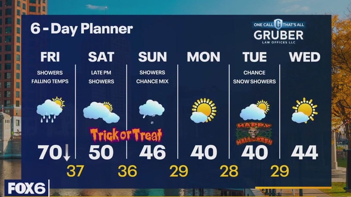
Weather webcast with Rob Haswell
A cold front approaches the area today. Ahead of it, we stay mild with an early high near 70. Once it passes, temperatures fall rapidly. We should be in the 30s overnight. A few more showers and possibly an isolated thunderstorm as this front passes then we calm down for a few hours with showers returning late Saturday evening. More showers likely on Sunday and staying chilly through the weekend. Cold early next week with lows in the 20s and highs in the low 40s. Flurries possible Tuesday.
A cold front approaches the area today. Ahead of it, we stay mild with an early high near 70. Once it passes, temperatures fall rapidly. We should be in the 30s overnight. A few more showers and possibly an isolated thunderstorm as this front passes then we calm down for a few hours with showers returning late Saturday evening. More showers likely on Sunday and staying chilly through the weekend. Cold early next week with lows in the 20s and highs in the low 40s. Flurries possible Tuesday.
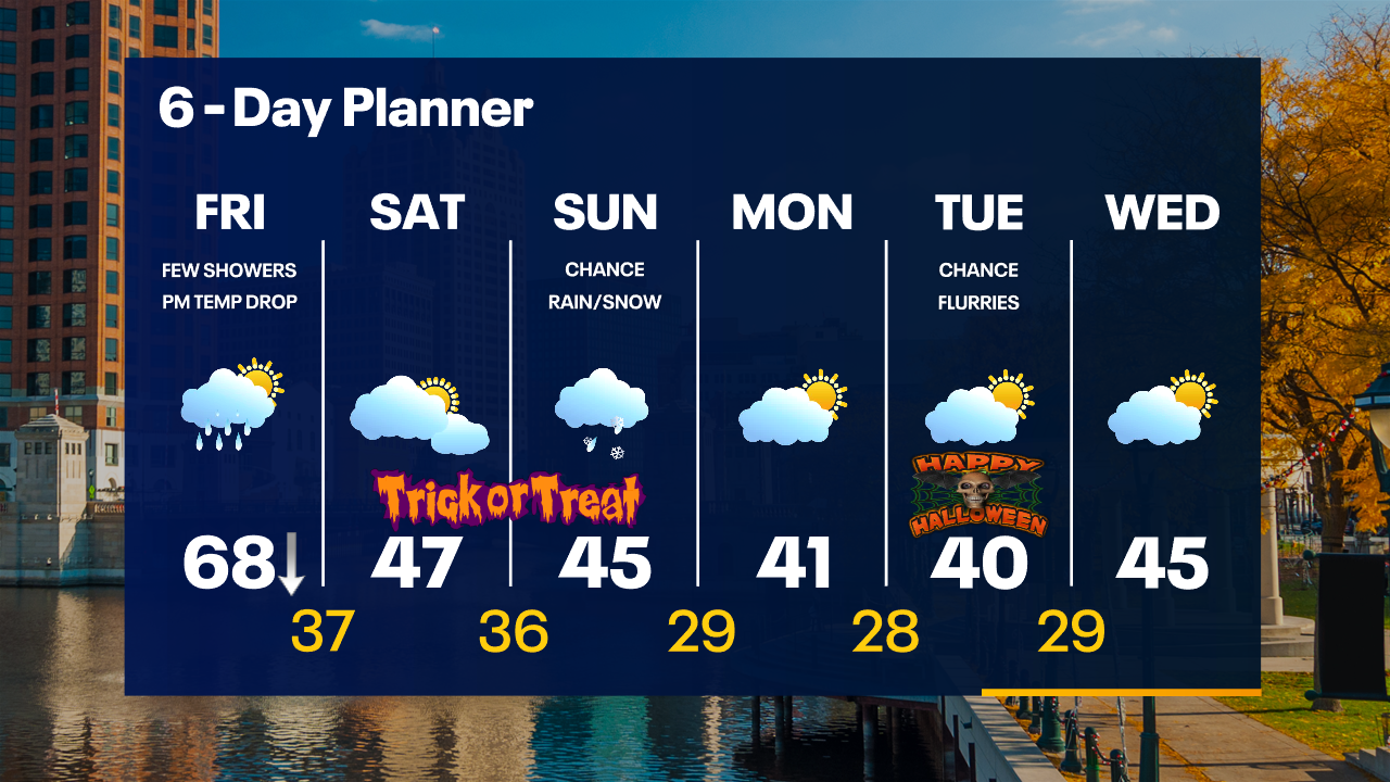
Weather Webcast with Tom Wachs
Rain tapering off overnight. Scattered rain showers on Friday ahead of a cold front that will move through early in the afternoon. A BIG temperature drop expected. 60s through early afternoon, 40s by early evening.
Rain tapering off overnight. Scattered rain showers on Friday ahead of a cold front that will move through early in the afternoon. A BIG temperature drop expected. 60s through early afternoon, 40s by early evening.
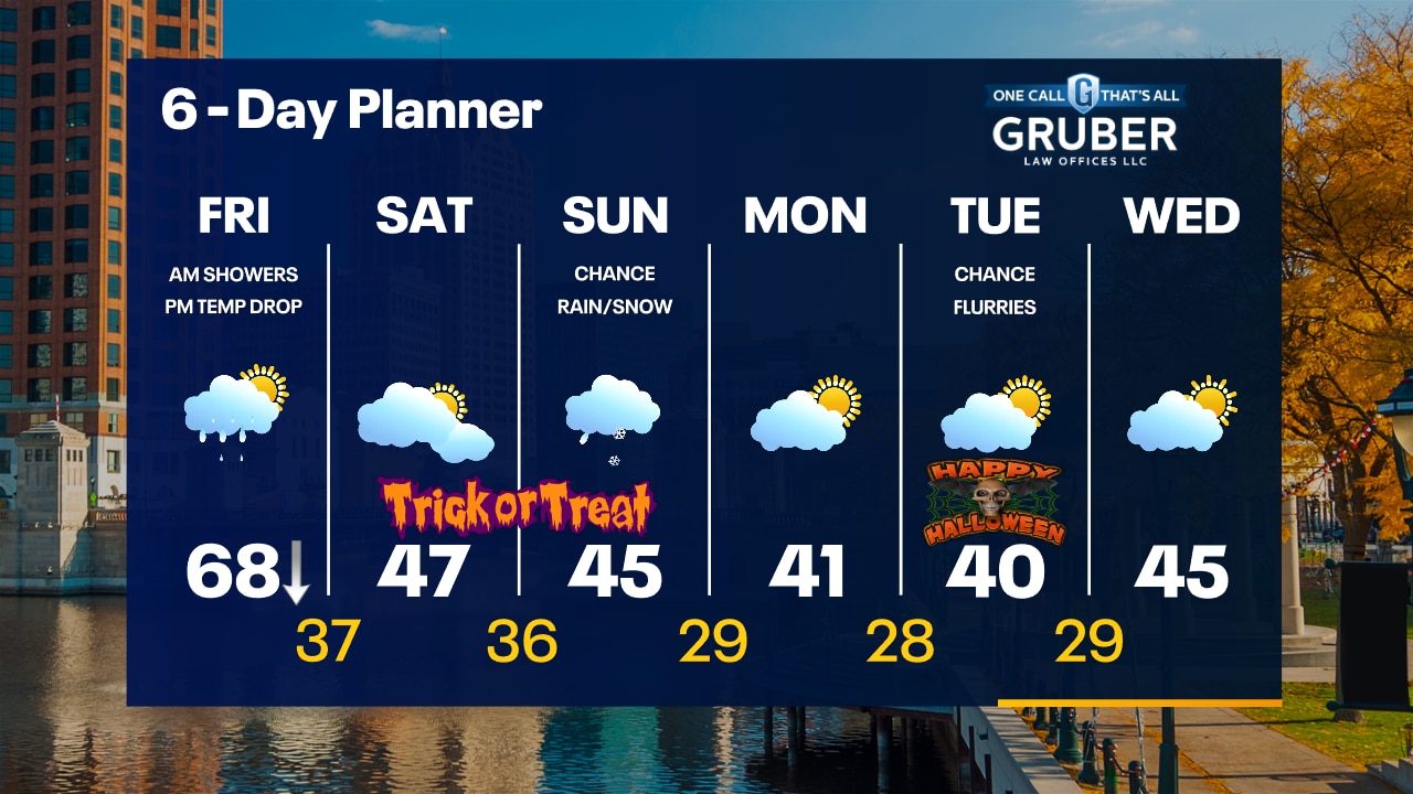
Weather Webcast with Tom Wachs
Rain gradually tapering off tonight with temperatures in the 60s all night. A BIG temperature drop is on the way Friday. Light rain showers through midday with AM temperatures in the 60s. Temperatures drop into the 40s late in the day.
Rain gradually tapering off tonight with temperatures in the 60s all night. A BIG temperature drop is on the way Friday. Light rain showers through midday with AM temperatures in the 60s. Temperatures drop into the 40s late in the day.
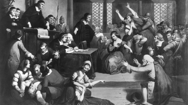

How cold weather helped cause the Salem witch trials
In 1692 and 1693, the Salem witch trials were held in northeastern Massachusetts and led to the prosecution of more than 150 people.
In 1692 and 1693, the Salem witch trials were held in northeastern Massachusetts and led to the prosecution of more than 150 people.
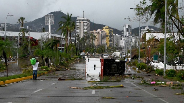

'Acapulco has been destroyed': Hurricane Otis blamed for 27 deaths as survivors recover from historic storm
Acapulco, known as the Pearl of the Pacific, is recovering after being pummeled by deadly Hurricane Otis, the most powerful storm on record for the Pacific coast of Mexico.
Acapulco, known as the Pearl of the Pacific, is recovering after being pummeled by deadly Hurricane Otis, the most powerful storm on record for the Pacific coast of Mexico.

Weather Webcast with Meteorologist Eric Manges
Rainy conditions continue through Friday but then the colder air returns this weekend
Rainy conditions continue through Friday but then the colder air returns this weekend
Weather webcast with Rob Haswell
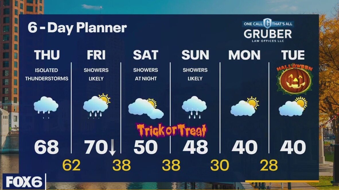
A surge of moisture travels Northeast into our area bringing periods of rain today and tapering to showers tonight. We stay on the warm side of the front today with highs in the upper 60s and should get to near 70 early Friday before a strong cold front drops us into the 30s. We stay on the chilly side from Friday night through the middle of next week. Highs will be in the low 50s this weekend with showers late Saturday and periods of light rain Sunday. Chilly Halloween forecast with highs barely reaching 40.
A surge of moisture travels Northeast into our area bringing periods of rain today and tapering to showers tonight. We stay on the warm side of the front today with highs in the upper 60s and should get to near 70 early Friday before a strong cold front drops us into the 30s. We stay on the chilly side from Friday night through the middle of next week. Highs will be in the low 50s this weekend with showers late Saturday and periods of light rain Sunday. Chilly Halloween forecast with highs barely reaching 40.
Weather Webcast with Tom Wachs
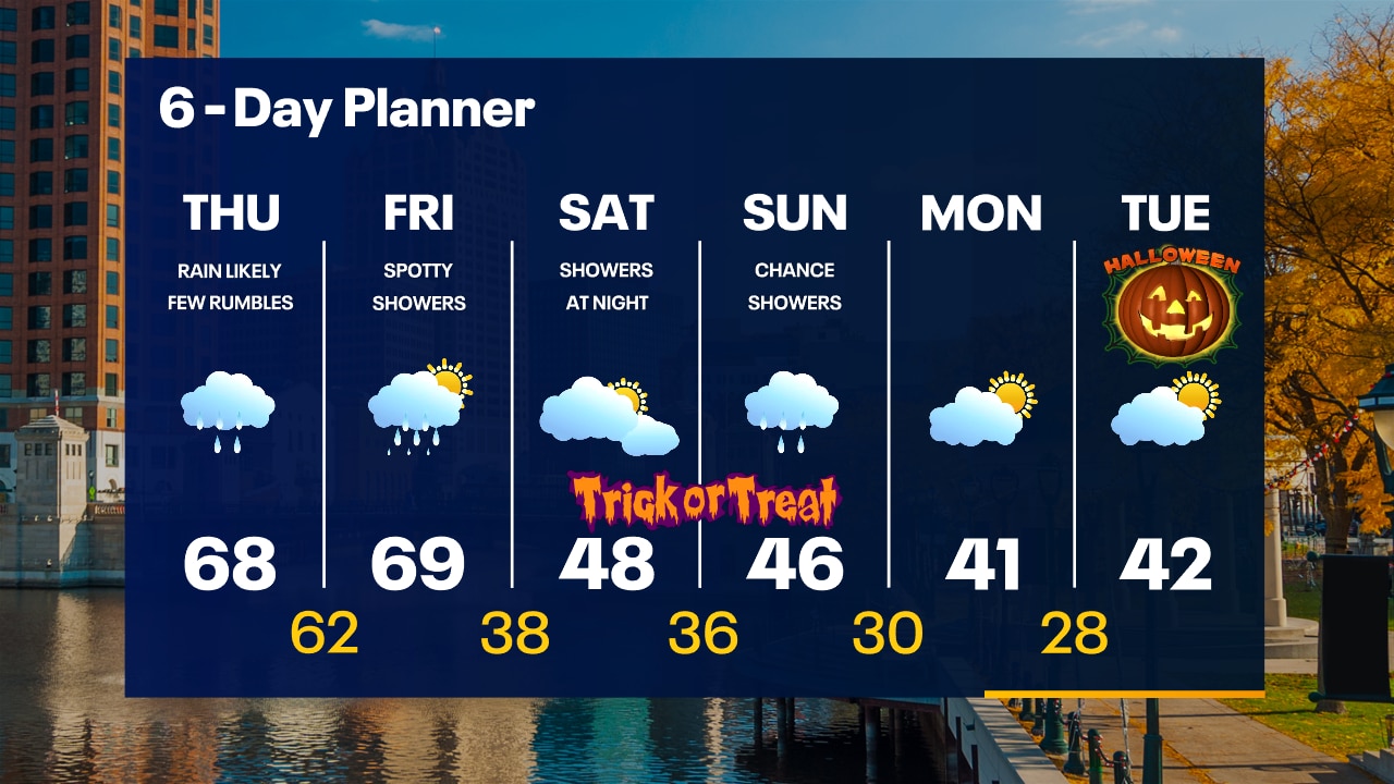
Rain moving in overnight with areas of fog. Temperatures in the 60s. Soggy on Thursday with showers and embedded t-storms. Breezy with highs in the 60s.
Rain moving in overnight with areas of fog. Temperatures in the 60s. Soggy on Thursday with showers and embedded t-storms. Breezy with highs in the 60s.
Weather Webcast with Tom Wachs
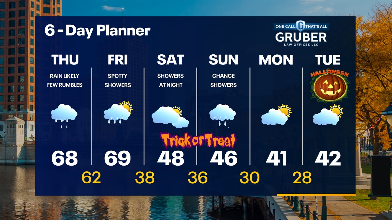
Rain moves in after midnight. Temperatures in the 60s tonight. Soggy on Thursday with rain for most of the day with embedded t-storms. Breezy with highs in the 60s.
Rain moves in after midnight. Temperatures in the 60s tonight. Soggy on Thursday with rain for most of the day with embedded t-storms. Breezy with highs in the 60s.


Hurricane Otis makes historic Category 5 landfall as 'nightmare scenario' unfolds near Acapulco, Mexico
Otis was the strongest hurricane to ever make landfall on the Pacific side of Mexico. It was also the first time an Eastern Pacific hurricane made landfall at Category 5 intensity.
Otis was the strongest hurricane to ever make landfall on the Pacific side of Mexico. It was also the first time an Eastern Pacific hurricane made landfall at Category 5 intensity.
Weather webcast with Rob Haswell
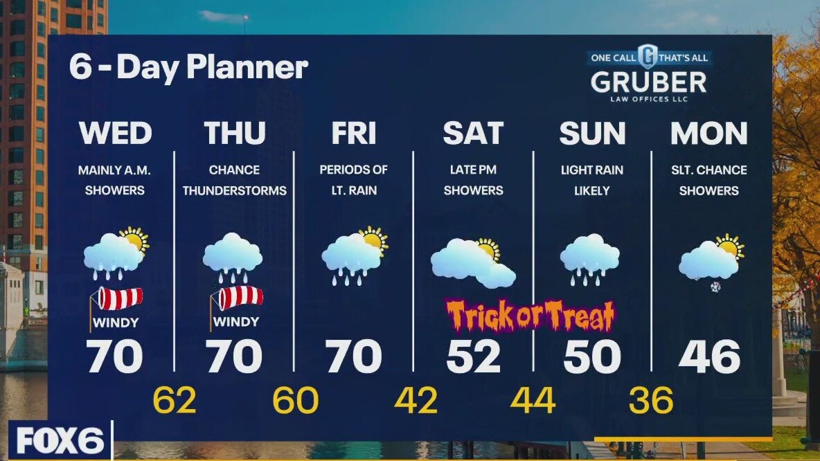
A push of moisture across our area ahead of a frontal boundary today will keep showers going for the morning and midday but we should dry up for a bit this afternoon. Highs today will be near 70 and we stay mild overnight - likely in the low 60s which would be a record warm low for the date. Average lows are in the low 40s! A much more significant surge of rain arrives Thursday ahead of a slowly approaching cold front. Highs will still reach 70 despite the rain and we should briefly hit 70 again Friday before the front passes. Once the cold front clears on Friday, temperatures go into freefall! We should drop from a high near 70 to the low 40s Friday night and only see highs in the upper 40s and low 50s through the weekend and early next week.
A push of moisture across our area ahead of a frontal boundary today will keep showers going for the morning and midday but we should dry up for a bit this afternoon. Highs today will be near 70 and we stay mild overnight - likely in the low 60s which would be a record warm low for the date. Average lows are in the low 40s! A much more significant surge of rain arrives Thursday ahead of a slowly approaching cold front. Highs will still reach 70 despite the rain and we should briefly hit 70 again Friday before the front passes. Once the cold front clears on Friday, temperatures go into freefall! We should drop from a high near 70 to the low 40s Friday night and only see highs in the upper 40s and low 50s through the weekend and early next week.

Weather Webcast with Stephanie Barichello
Rain showers return overnight and Wednesday morning, then some dry time with a high around 70. Better chance for rain on Thursday with a few lingering showers Friday. Chilly over the weekend with rain on Sunday.
Rain showers return overnight and Wednesday morning, then some dry time with a high around 70. Better chance for rain on Thursday with a few lingering showers Friday. Chilly over the weekend with rain on Sunday.


Halloween horror: Bone-chilling blast of cold air to arrive in time for trick-or-treating
Frightful weather is in the forecast for parts of the U.S. during Halloween weekend, along with bone-chilling cold for next week's holiday.
Frightful weather is in the forecast for parts of the U.S. during Halloween weekend, along with bone-chilling cold for next week's holiday.
Weather webcast with Lisa Michaels
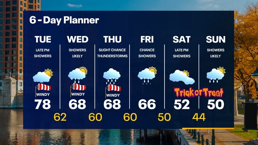
A warm front lifts across our area today pushing temperatures into the mid to upper 70s! A strong southwest wind will gust into the 30mph range at times. A chance for showers returns by later today and tonight with another chance for rain Wednesday. We should see our wettest day on Thursday then dry up as we cool day by the weekend.
A warm front lifts across our area today pushing temperatures into the mid to upper 70s! A strong southwest wind will gust into the 30mph range at times. A chance for showers returns by later today and tonight with another chance for rain Wednesday. We should see our wettest day on Thursday then dry up as we cool day by the weekend.


Portions of Louisiana interstate remain closed after deadly pileup caused by super fog outside New Orleans
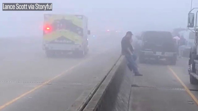
Louisiana State Police said nearly 160 vehicles were involved in the pileup on Monday. At least seven people were killed, and dozens more were injured.
Louisiana State Police said nearly 160 vehicles were involved in the pileup on Monday. At least seven people were killed, and dozens more were injured.

What is super fog and what causes it?
Every year fog leads to numerous delays on the roads and in the air, and even leads to fatalities. And while there are several different types of fog, super fog can be especially dangerous for drivers.
Every year fog leads to numerous delays on the roads and in the air, and even leads to fatalities. And while there are several different types of fog, super fog can be especially dangerous for drivers.
Weather webcast with Rob Haswell
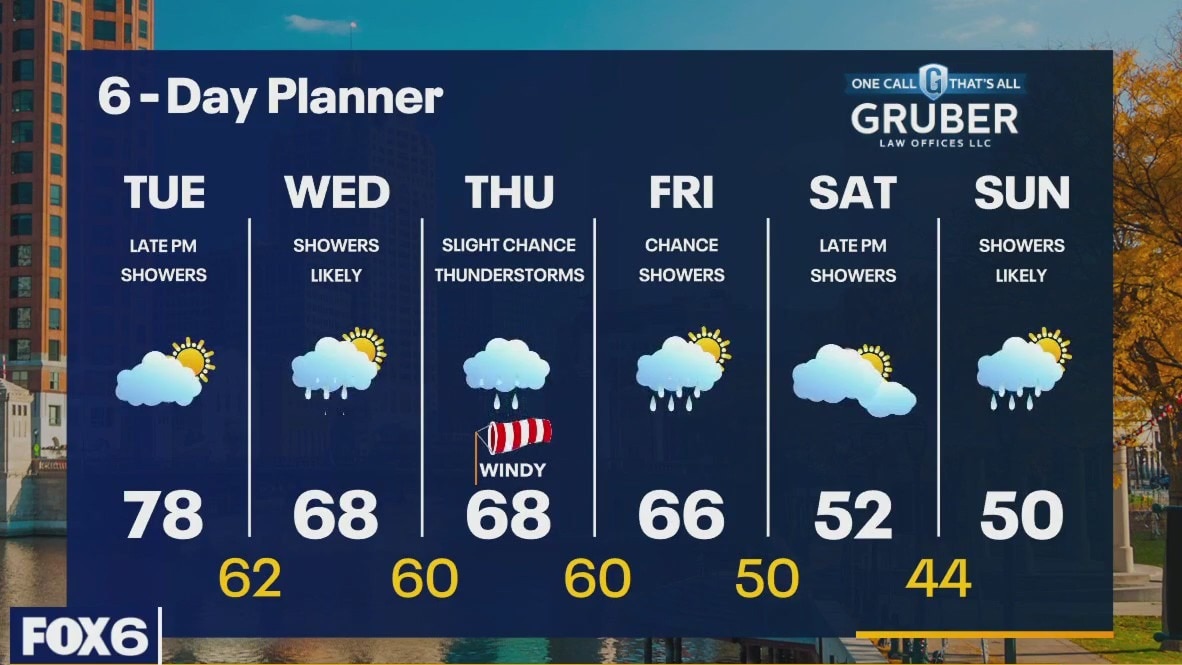
A warm front lifts across our area today pushing temperatures into the mid to upper 70s! A strong southwest wind will gust into the 30mph range at times. A chance for showers returns by later today and tonight with another chance for rain Wednesday. We should see our wettest day on Thursday then dry up as we cool day by the weekend.
A warm front lifts across our area today pushing temperatures into the mid to upper 70s! A strong southwest wind will gust into the 30mph range at times. A chance for showers returns by later today and tonight with another chance for rain Wednesday. We should see our wettest day on Thursday then dry up as we cool day by the weekend.
Weather Webcast with Stephanie Barichello
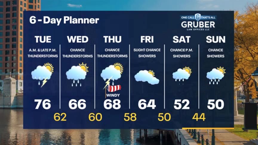
Drying out tonight, then a few showers will possible north of Milwaukee Tuesday morning. Windy and warm Tuesday in the middle 70s, with rain filling back in Tuesday night. The chance for rain at times will last all the way through the weekend. Temperatures will drop into the low 50s by the weekend, as well.
Drying out tonight, then a few showers will possible north of Milwaukee Tuesday morning. Windy and warm Tuesday in the middle 70s, with rain filling back in Tuesday night. The chance for rain at times will last all the way through the weekend. Temperatures will drop into the low 50s by the weekend, as well.
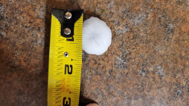

Watertown hail after severe thunderstorm warning Monday
The National Weather Service issued a severe thunderstorm warning for parts of Dodge and Jefferson counties Monday afternoon, Oct. 23.
The National Weather Service issued a severe thunderstorm warning for parts of Dodge and Jefferson counties Monday afternoon, Oct. 23.