


Weather Webcast with Stephanie Barichello
Clear and cold tonight with lows in the teens and 20s, then more sunshine Monday and a high around 44. We continue to climb through midweek with a few chances for 50s. Only chance for precip will be on Wednesday.
Clear and cold tonight with lows in the teens and 20s, then more sunshine Monday and a high around 44. We continue to climb through midweek with a few chances for 50s. Only chance for precip will be on Wednesday.
Weather webcast with Lisa Michaels
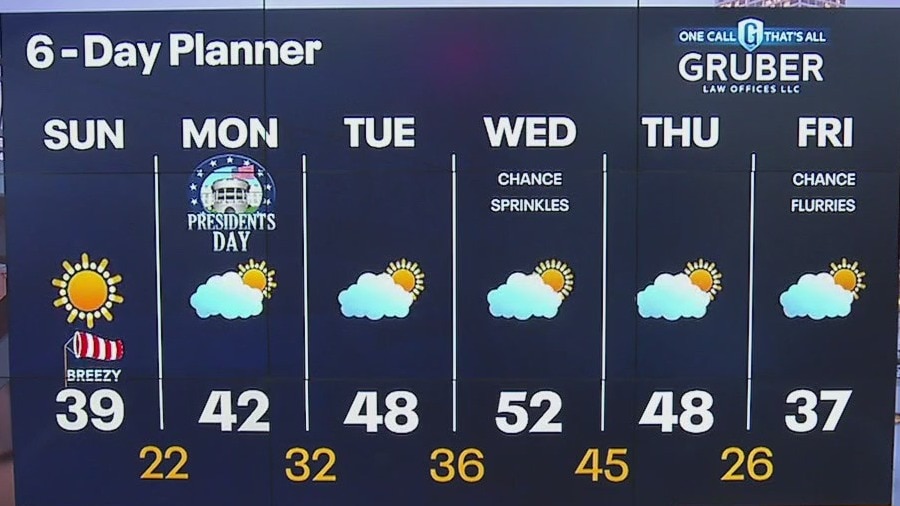
A cool morning in the low to mid 20s. Sunny skies on Sunday with highs in the upper 30s. The warming trend will continue through the middle of next week. Temperatures will be back in the upper 40s to low 50s. There is a slight chance of a few sprinkles on Wednesday with the passing of a cold front. Otherwise, a dry forecast ahead. Slightly cooler temperatures look to return by the end of the week.
A cool morning in the low to mid 20s. Sunny skies on Sunday with highs in the upper 30s. The warming trend will continue through the middle of next week. Temperatures will be back in the upper 40s to low 50s. There is a slight chance of a few sprinkles on Wednesday with the passing of a cold front. Otherwise, a dry forecast ahead. Slightly cooler temperatures look to return by the end of the week.

Weather Webcast with Stephanie Barichello
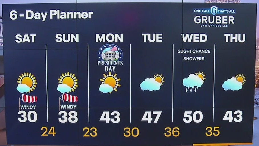
Not as cold tonight but still windy, then warming into the upper 30s on Sunday. 40s return next week and even a chance at 50s Wednesday. Only a slight chance for sprinkles midweek and flurries Friday.
Not as cold tonight but still windy, then warming into the upper 30s on Sunday. 40s return next week and even a chance at 50s Wednesday. Only a slight chance for sprinkles midweek and flurries Friday.
Weather webcast with Lisa Michaels
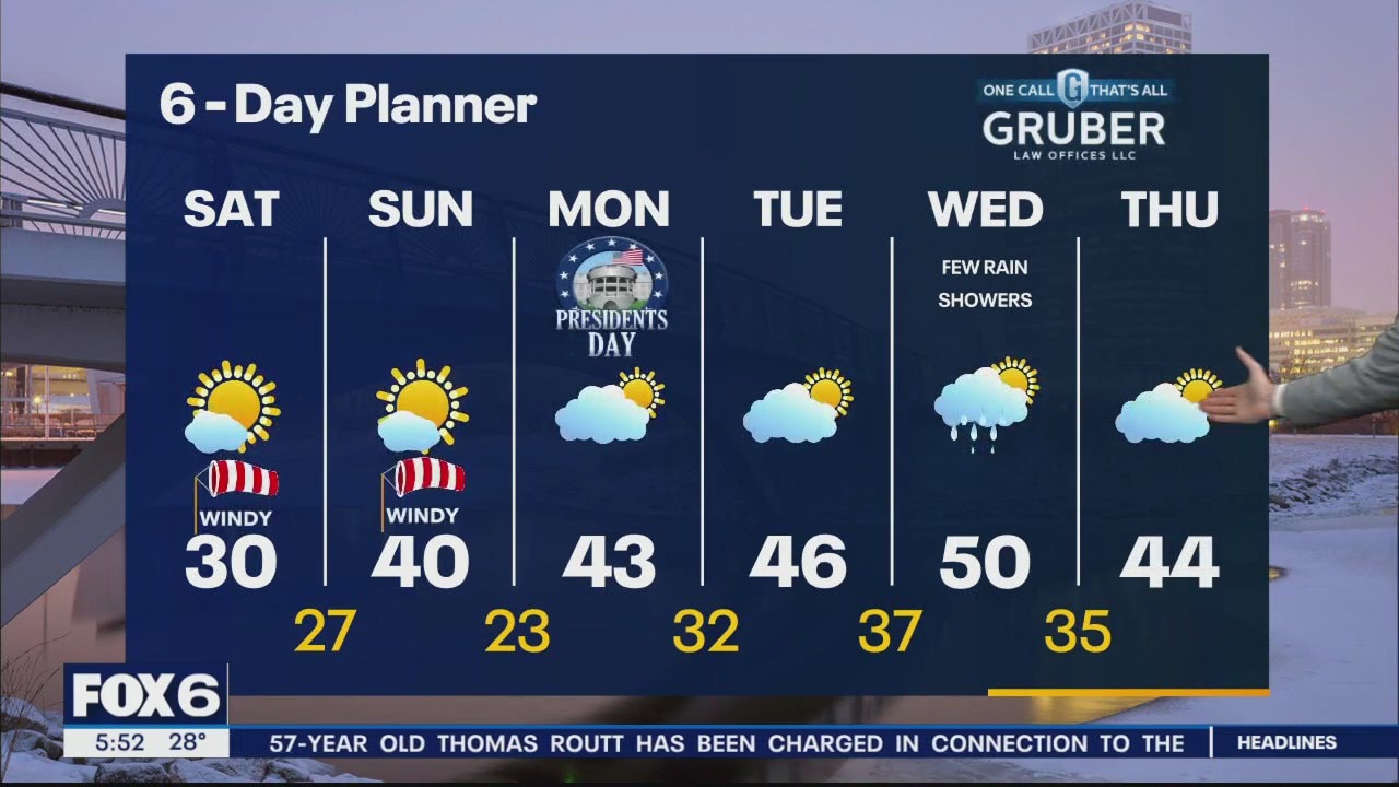
Chilly morning with wind chills 5F to -5F. High temps reach the upper 20s to low 30s on Saturday with mostly sunny skies. Mostly sunny conditions over the next four days before more clouds develop on Wednesday. A gradual warming trend back near 50F by Wednesday. Our only real chance of precipitation comes in Wednesday but even that looks spotty.
Chilly morning with wind chills 5F to -5F. High temps reach the upper 20s to low 30s on Saturday with mostly sunny skies. Mostly sunny conditions over the next four days before more clouds develop on Wednesday. A gradual warming trend back near 50F by Wednesday. Our only real chance of precipitation comes in Wednesday but even that looks spotty.
Weather Webcast with Meteorologist Eric Manges
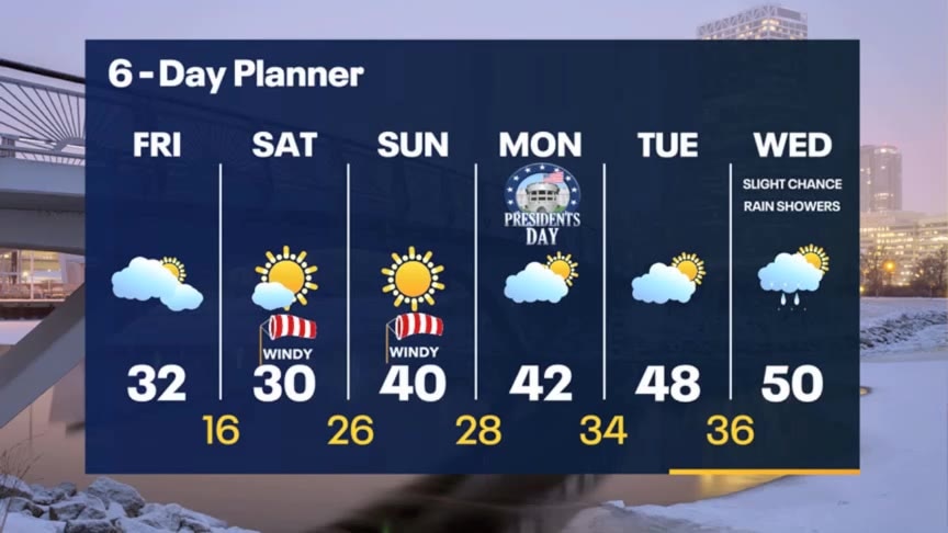
Cold to start Saturday but then a warm up into next week
Cold to start Saturday but then a warm up into next week
Weather Webcast with Stephanie Barichello
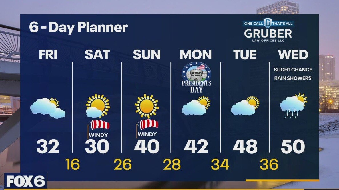
Mostly cloudy and chilly today, then even colder tonight as lows drop into the teens by morning. Wind chills will likely be around or just below 0. We struggle to reach 30 Saturday then jump to nearly 40 on Sunday.
Mostly cloudy and chilly today, then even colder tonight as lows drop into the teens by morning. Wind chills will likely be around or just below 0. We struggle to reach 30 Saturday then jump to nearly 40 on Sunday.
Weather webcast with Rob Haswell
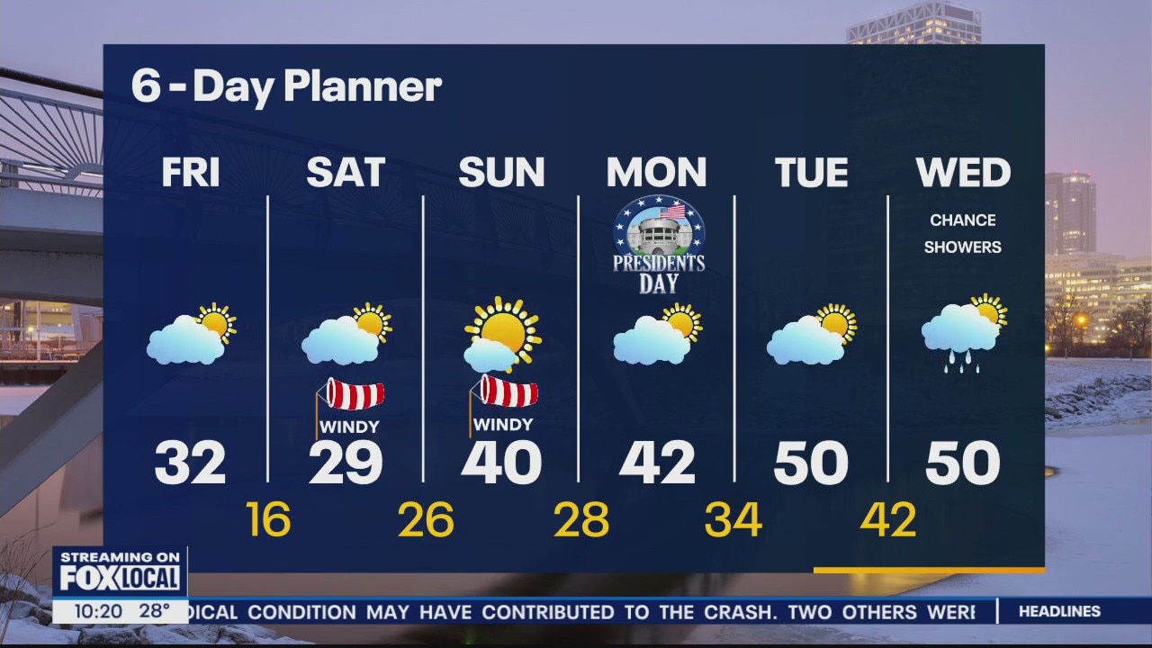
A system passing to our south today may bring a few flurries to areas near the IL state line but otherwise we are dry today with some sunny breaks in the afternoon. Temperatures will be cooler with highs in the low 30s today and again tomorrow. We start another warm up Sunday as we return to near 40 and warm to near 50 by the middle of next week. We will be dry for several days with our next chance of precipitation later Wednesday into Thursday.
A system passing to our south today may bring a few flurries to areas near the IL state line but otherwise we are dry today with some sunny breaks in the afternoon. Temperatures will be cooler with highs in the low 30s today and again tomorrow. We start another warm up Sunday as we return to near 40 and warm to near 50 by the middle of next week. We will be dry for several days with our next chance of precipitation later Wednesday into Thursday.
Weather Webcast with Meteorologist Eric Manges
One of our warmest starts to February ever and a warm up next week will only add to it
One of our warmest starts to February ever and a warm up next week will only add to it

Weather Webcast with Meteorologist Eric Manges
Colder into the weekend then bouncing back warmer than average next week
Colder into the weekend then bouncing back warmer than average next week

Snowfall totals: Wisconsin winter storm Thursday, Feb. 15
The National Weather Service (NWS) is collecting snowfall data from the Thursday, Feb. 15 winter storm that impacted southeastern Wisconsin.
The National Weather Service (NWS) is collecting snowfall data from the Thursday, Feb. 15 winter storm that impacted southeastern Wisconsin.

Slippery road conditions linger; winter weather advisory ends
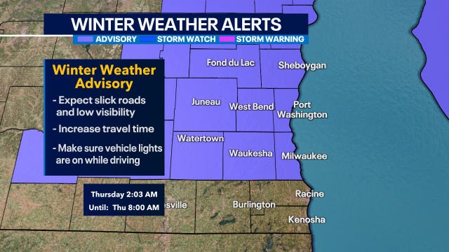
The National Weather Service has issued a winter weather advisory for parts of southeast Wisconsin from midnight through 8 a.m. on Thursday, Feb. 15.
The National Weather Service has issued a winter weather advisory for parts of southeast Wisconsin from midnight through 8 a.m. on Thursday, Feb. 15.
Weather webcast with Rob Haswell
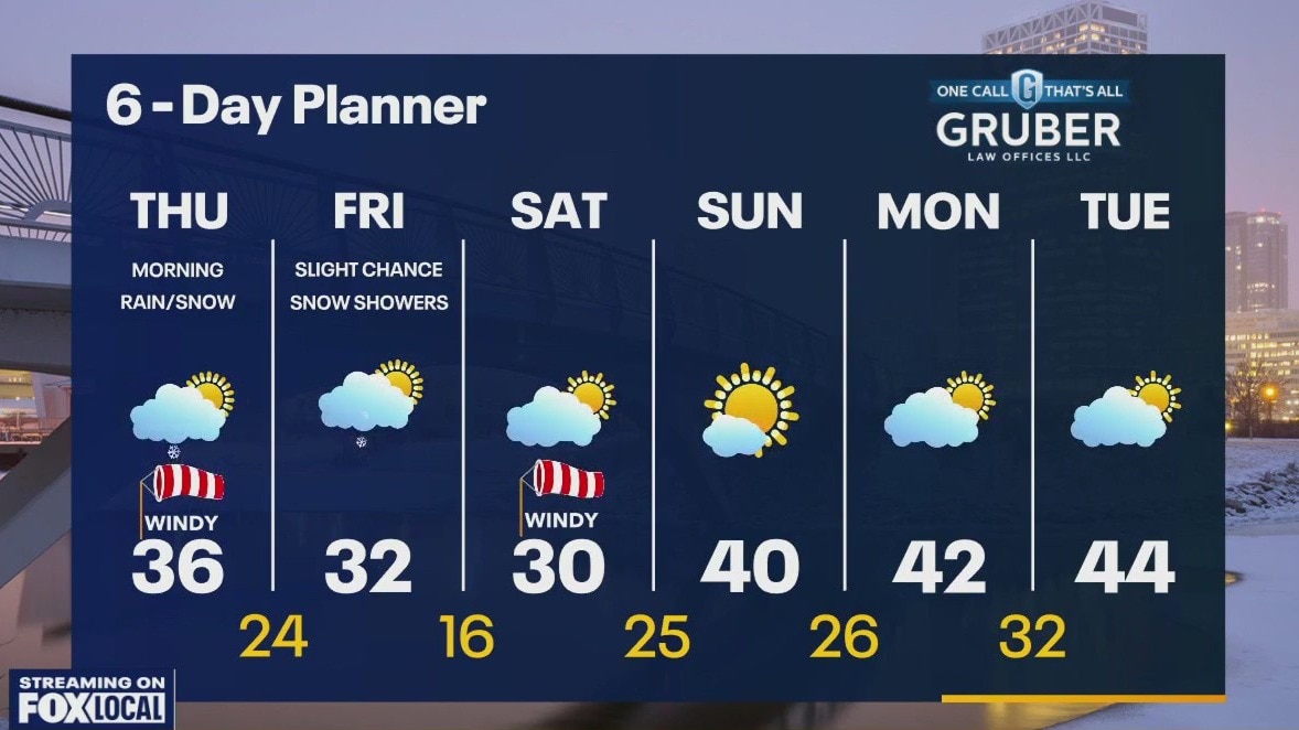
Winter Weather Advisory for Milwaukee, Ozaukee, Washington, Dodge, Fond du Lac and Sheboygan counties until 8 a.m. Thursday. 2-5" expected in advisory areas with a rain/mix south. Windy through the midday into the afternoon with wind gusts 30-40mph at times. Wind speeds will calm late today and tonight. Cooler air arrives for Friday and Saturday but we warm again next week.
Winter Weather Advisory for Milwaukee, Ozaukee, Washington, Dodge, Fond du Lac and Sheboygan counties until 8 a.m. Thursday. 2-5" expected in advisory areas with a rain/mix south. Windy through the midday into the afternoon with wind gusts 30-40mph at times. Wind speeds will calm late today and tonight. Cooler air arrives for Friday and Saturday but we warm again next week.

Wisconsin February tornadoes cause $2.4M in damages
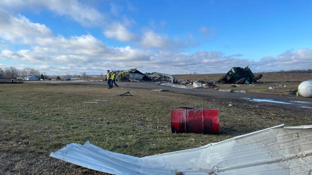
The first tornadoes ever recorded in Wisconsin in the usually frigid month of February caused more than $2.4 million in damage, officials said Wednesday.
The first tornadoes ever recorded in Wisconsin in the usually frigid month of February caused more than $2.4 million in damage, officials said Wednesday.
Weather Webcast with Tom Wachs
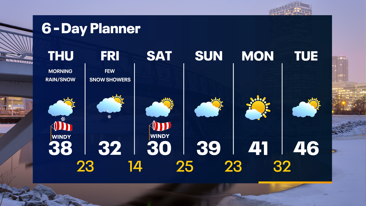
Rain and snow overnight from 12am-8am. 1-3" possible in Milwaukee, 2-5" north, lower south. This will be a heavy, wet, impactful snow. While the precipitation ends around 8am, roads could still be a mess. Expect some sun by afternoon.
Rain and snow overnight from 12am-8am. 1-3" possible in Milwaukee, 2-5" north, lower south. This will be a heavy, wet, impactful snow. While the precipitation ends around 8am, roads could still be a mess. Expect some sun by afternoon.
Weather Webcast with Tom Wachs
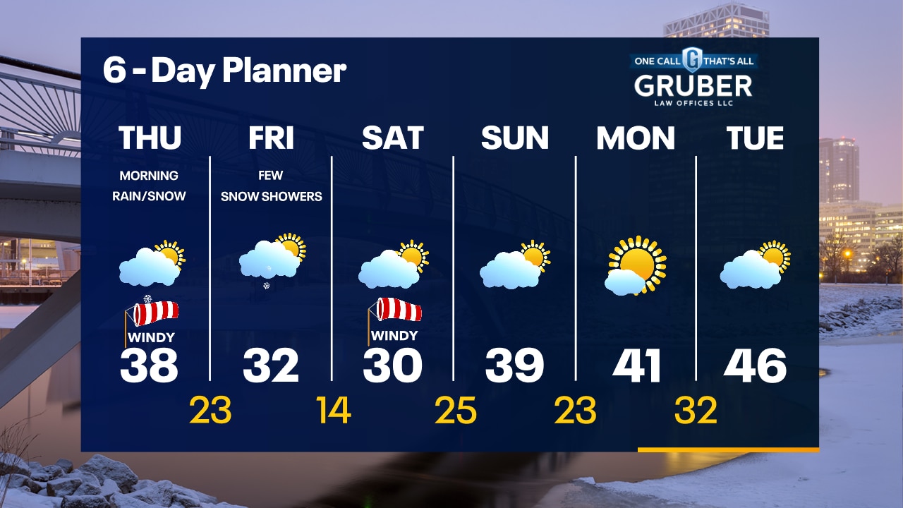
Winter Weather Advisory north of Milwaukee overnight. A few inches of snow overnight in Milwaukee, 2-5" of heavy/wet snow north of the city. A messy AM commute possible.
Winter Weather Advisory north of Milwaukee overnight. A few inches of snow overnight in Milwaukee, 2-5" of heavy/wet snow north of the city. A messy AM commute possible.

How the fading El Nino pattern will impact hurricane season activity in 2024
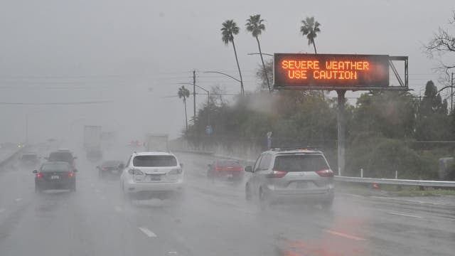
Historically, La Niñas have produced busy tropical seasons, while the opposite is known to be true during El Niños - when conditions are typically hostile for cyclones in the Atlantic basin.
Historically, La Niñas have produced busy tropical seasons, while the opposite is known to be true during El Niños - when conditions are typically hostile for cyclones in the Atlantic basin.

Watch: Michigan deputies perform ice rescue to save trapped ATV rider
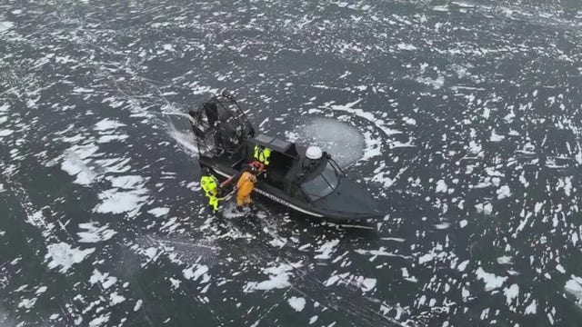
One person is safe after falling through thin ice in Michigan's Upper Peninsula on Tuesday.
One person is safe after falling through thin ice in Michigan's Upper Peninsula on Tuesday.

Weather webcast with Lisa Michaels
Some morning sun then more clouds today. A strong SW wind will help us warm into the low 40s. Rain, snow and a wintry mix arrives overnight. A Winter Weather Advisory goes into effect at midnight for Washington, Dodge, Sheboygan and Fond du Lac counties. A few inches of snow are possible in areas north and west of Milwaukee with a wintry mix and rain likely for the Milwaukee Metro and south. After the rain/snow ends, the wind becomes a big issue with gusts near 30-35mph on Thursday.
Some morning sun then more clouds today. A strong SW wind will help us warm into the low 40s. Rain, snow and a wintry mix arrives overnight. A Winter Weather Advisory goes into effect at midnight for Washington, Dodge, Sheboygan and Fond du Lac counties. A few inches of snow are possible in areas north and west of Milwaukee with a wintry mix and rain likely for the Milwaukee Metro and south. After the rain/snow ends, the wind becomes a big issue with gusts near 30-35mph on Thursday.

Weather webcast with Rob Haswell
Some morning sun then more clouds today. A strong SW wind will help us warm into the low 40s. Rain, snow and a wintry mix arrives overnight. A Winter Weather Advisory goes into effect at midnight for Washington, Dodge, Sheboygan and Fond du Lac counties. A few inches of snow are possible in areas north and west of Milwaukee with a wintry mix and rain likely for the Milwaukee Metro and south. After the rain/snow ends, the wind becomes a big issue with gusts near 30-35mph on Thursday.
Some morning sun then more clouds today. A strong SW wind will help us warm into the low 40s. Rain, snow and a wintry mix arrives overnight. A Winter Weather Advisory goes into effect at midnight for Washington, Dodge, Sheboygan and Fond du Lac counties. A few inches of snow are possible in areas north and west of Milwaukee with a wintry mix and rain likely for the Milwaukee Metro and south. After the rain/snow ends, the wind becomes a big issue with gusts near 30-35mph on Thursday.
Weather Webcast with Tom Wachs
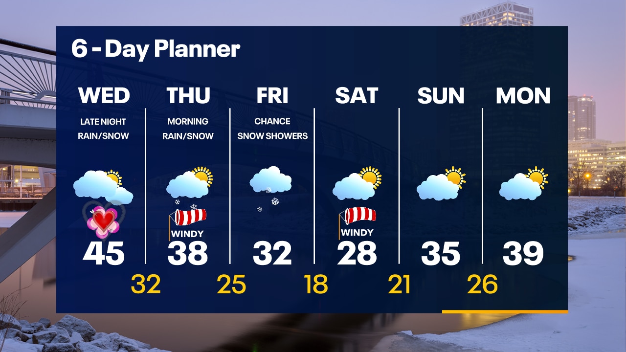
Warmer on Valentine's Day with highs in the 40s. The rain/snow chances are shifting a bit north for Thursday morning. Accumulating snow possible north of Milwaukee early Thursday.
Warmer on Valentine's Day with highs in the 40s. The rain/snow chances are shifting a bit north for Thursday morning. Accumulating snow possible north of Milwaukee early Thursday.