


Weather Webcast with Chief Meteorologist Tom Wachs
Quiet tonight into the Thursday AM commute. Snow moves in by late morning on Thursday and really picks up late in the afternoon. Slow for the evening commute Thursday and the morning commute on Friday. 2-4" in Milwaukee, higher north, lower to the south.
Quiet tonight into the Thursday AM commute. Snow moves in by late morning on Thursday and really picks up late in the afternoon. Slow for the evening commute Thursday and the morning commute on Friday. 2-4" in Milwaukee, higher north, lower to the south.
Weather Webcast with Stephanie Barichello
All eyes on snow potential on Thursday. Light snow moves in by mid-morning Thursday then ramps up Thursday afternoon and evening into Friday morning. Highest impacts and messiest travel will be Thursday evening into Friday morning. Most looking at 2-4" at this time, with higher amounts possible north where a Winter Storm Watch is in effect. There could be lake enhancement Thursday night leading to higher snowfall rates and totals across Fond du Lac, Sheboygan and even Ozaukee Co. Stay tuned. Sunshine returns Friday afternoon.
All eyes on snow potential on Thursday. Light snow moves in by mid-morning Thursday then ramps up Thursday afternoon and evening into Friday morning. Highest impacts and messiest travel will be Thursday evening into Friday morning. Most looking at 2-4" at this time, with higher amounts possible north where a Winter Storm Watch is in effect. There could be lake enhancement Thursday night leading to higher snowfall rates and totals across Fond du Lac, Sheboygan and even Ozaukee Co. Stay tuned. Sunshine returns Friday afternoon.

Weather Webcast with Chief Meteorologist Rob Haswell
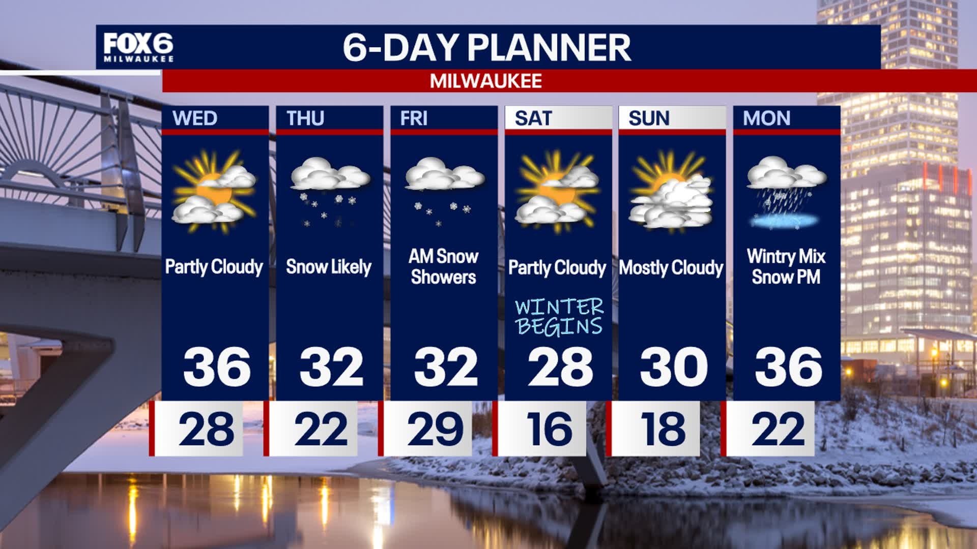
A cloudy start, then a bit of sunshine on Wednesday; highs will be in the low-to-mid 30s. Another round of snow is expected for Thursday.
A cloudy start, then a bit of sunshine on Wednesday; highs will be in the low-to-mid 30s. Another round of snow is expected for Thursday.

Weather Webcast with Chief Meteorologist Tom Wachs
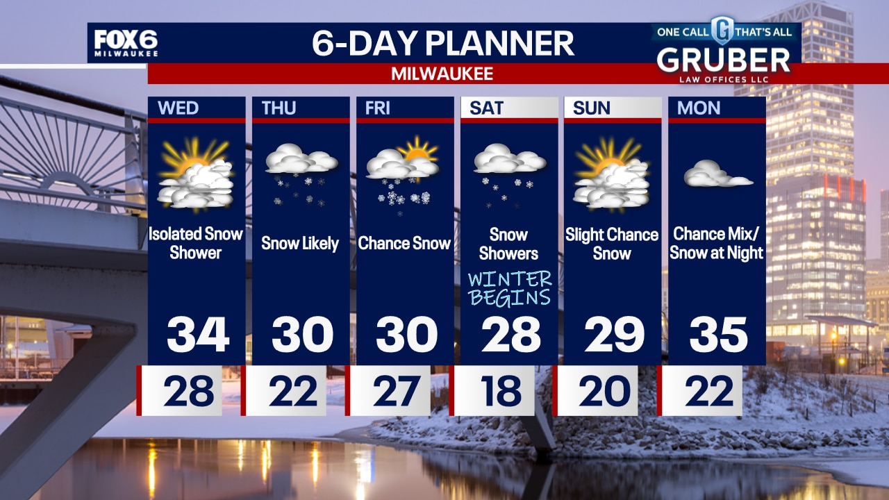
Light snow will move through overnight, mainly south of Milwaukee. A dusting is possible, especially close to the Illinois border. The snow will be done by 4-5am. Mostly cloudy and blustery on Wednesday with an isolated snow shower possible. Highs in the 30s.
Light snow will move through overnight, mainly south of Milwaukee. A dusting is possible, especially close to the Illinois border. The snow will be done by 4-5am. Mostly cloudy and blustery on Wednesday with an isolated snow shower possible. Highs in the 30s.
Weather Webcast with Chief Meteorologist Tom Wachs
Light snow will move through the area late this evening and overnight. The greatest chance for a few tenths of an inch will be near the IL border. Snow will move out before the Wednesday AM commute. A greater chance for snow moves in on Thursday.
Light snow will move through the area late this evening and overnight. The greatest chance for a few tenths of an inch will be near the IL border. Snow will move out before the Wednesday AM commute. A greater chance for snow moves in on Thursday.


Southeast Wisconsin snow in the forecast; what you need to know
A low pressure system will bring light snow showers across southeast Wisconsin Tuesday, Dec. 17 at night into the early morning on Wednesday, Dec. 18.
A low pressure system will bring light snow showers across southeast Wisconsin Tuesday, Dec. 17 at night into the early morning on Wednesday, Dec. 18.


Wisconsin DOT winter road conditions; updated resources for drivers
The Wisconsin Department of Transportation has resources for drivers as winter rolls in. Updated 511 map categories provide more information.
The Wisconsin Department of Transportation has resources for drivers as winter rolls in. Updated 511 map categories provide more information.

Weather Webcast with Chief Meteorologist Rob Haswell
A bit cooler today with highs in the upper 30s to near 40 but still above average. Cooling enough this evening and overnight for a low pressure system to our south to give us some light snow as it passes south and east of us.
A bit cooler today with highs in the upper 30s to near 40 but still above average. Cooling enough this evening and overnight for a low pressure system to our south to give us some light snow as it passes south and east of us.
Weather Webcast with Chief Meteorologist Tom Wachs
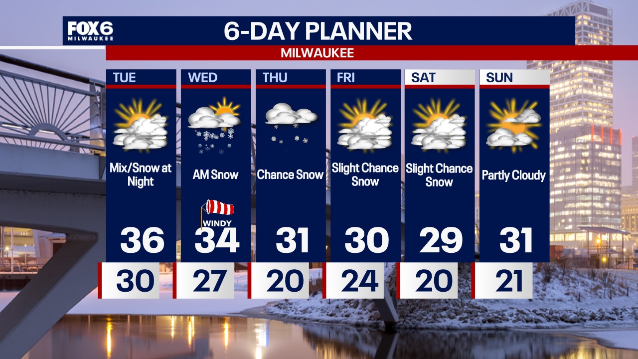
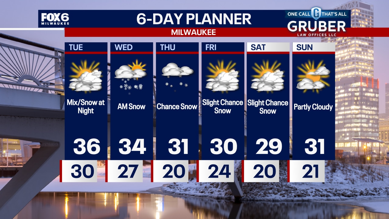
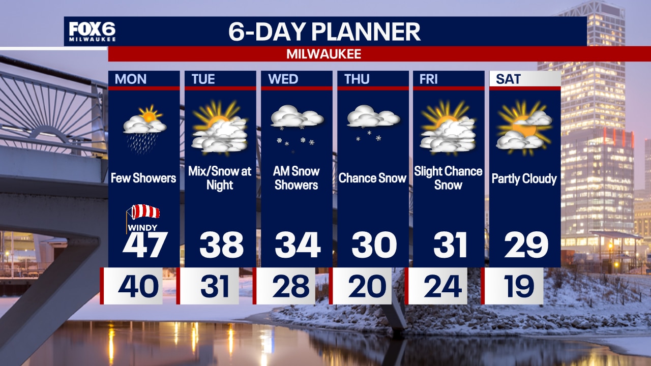
Windy overnight with temperatures dropping into the 30s. Mostly cloudy on Tuesday with highs in the mid-30s. A wintry mix/snow moves in mid-to-late evening Tuesday and ends before the AM commute on Wednesday.
Windy overnight with temperatures dropping into the 30s. Mostly cloudy on Tuesday with highs in the mid-30s. A wintry mix/snow moves in mid-to-late evening Tuesday and ends before the AM commute on Wednesday.
Weather Webcast with Chief Meteorologist Tom Wachs
Windy tonight with temperatures dropping through the 30s. Mostly cloudy on Tuesday with highs in the mid-30s. A wintry mix and light snow is possible late on Tuesday night.
Windy tonight with temperatures dropping through the 30s. Mostly cloudy on Tuesday with highs in the mid-30s. A wintry mix and light snow is possible late on Tuesday night.
Weather Webcast with Stephanie Barichello
Cloudy with a chance for sprinkles this afternoon, plus mild and windy. Drying out tonight and Tuesday, then a chance for wintry mix or light snow Tuesday night into Wednesday. Another quick system will bring light snow on Thursday, then colder temperatures to enter the weekend.
Cloudy with a chance for sprinkles this afternoon, plus mild and windy. Drying out tonight and Tuesday, then a chance for wintry mix or light snow Tuesday night into Wednesday. Another quick system will bring light snow on Thursday, then colder temperatures to enter the weekend.
Weather webcast with Lisa Michaels
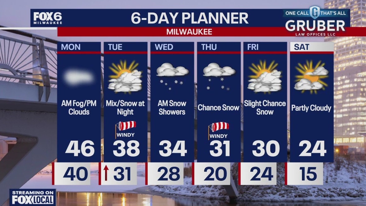
A misty and foggy Monday morning with a dense fog advisory through 9am. Fog will lessen during the afternoon as winds pick up.
A misty and foggy Monday morning with a dense fog advisory through 9am. Fog will lessen during the afternoon as winds pick up.

Weather Webcast with Chief Meteorologist Tom Wachs
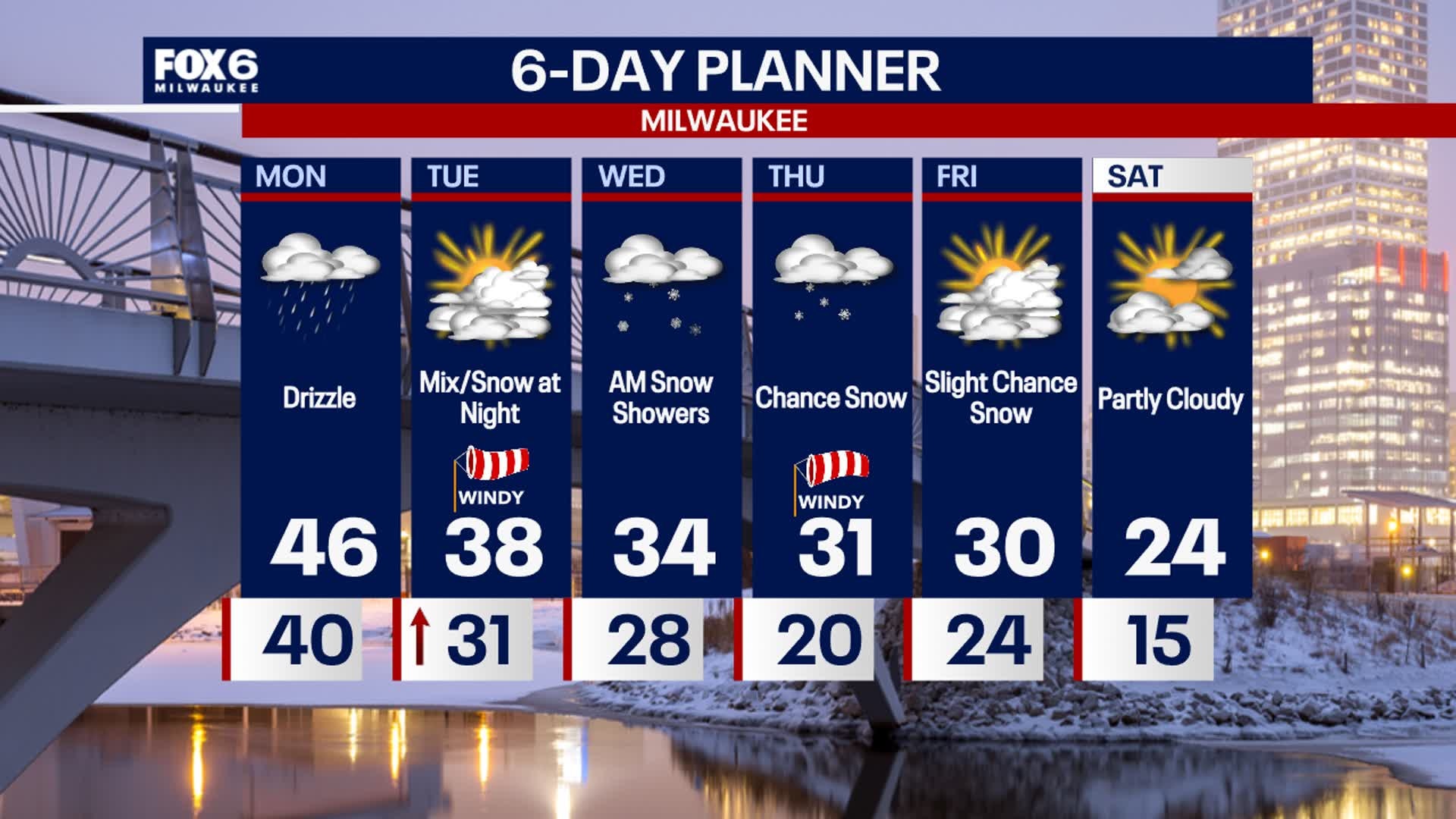
Areas of dense fog overnight along with a few light rain showers. Steady temperatures around 40. AM dense fog on Monday morning, otherwise cloudy and drizzly. Highs in the mid-40s with the wind picking up in the afternoon.
Areas of dense fog overnight along with a few light rain showers. Steady temperatures around 40. AM dense fog on Monday morning, otherwise cloudy and drizzly. Highs in the mid-40s with the wind picking up in the afternoon.


Ocean heat wave known as 'The Blob' blamed for killing half the population of bird species
The new study suggested that 4 million seabirds died following unusually warm conditions in the northeastern Pacific Ocean between 2014 and 2016.
The new study suggested that 4 million seabirds died following unusually warm conditions in the northeastern Pacific Ocean between 2014 and 2016.
Weather Webcast with Chief Meteorologist Tom Wachs
Cloudy and foggy tonight with a few light rain showers overnight. Temperatures hovering around 40. Cloudy with spotty light rain showers and drizzle on Monday with a mild high in the mid-to-upper 40s.
Cloudy and foggy tonight with a few light rain showers overnight. Temperatures hovering around 40. Cloudy with spotty light rain showers and drizzle on Monday with a mild high in the mid-to-upper 40s.

Weather webcast with Lisa Michaels
A misty and foggy Sunday transitioning to cloudy by the afternoon. Highs remain in the low 40s. There is a slight chance for a few light showers late Sunday into early Monday morning. Otherwise, mild with highs remaining in the low to mid 40s for the start of next week.
A misty and foggy Sunday transitioning to cloudy by the afternoon. Highs remain in the low 40s. There is a slight chance for a few light showers late Sunday into early Monday morning. Otherwise, mild with highs remaining in the low to mid 40s for the start of next week.

Webcast Weather with Holly Baker
A wintry mix will be transitioning into rain tonight.
A wintry mix will be transitioning into rain tonight.


Southeast Wisconsin winter weather advisory; slick roads possible
Portions of southeast Wisconsin have been added to a winter weather advisory from 3 p.m. Saturday afternoon through midnight Sunday.
Portions of southeast Wisconsin have been added to a winter weather advisory from 3 p.m. Saturday afternoon through midnight Sunday.
Weather webcast with Lisa Michaels
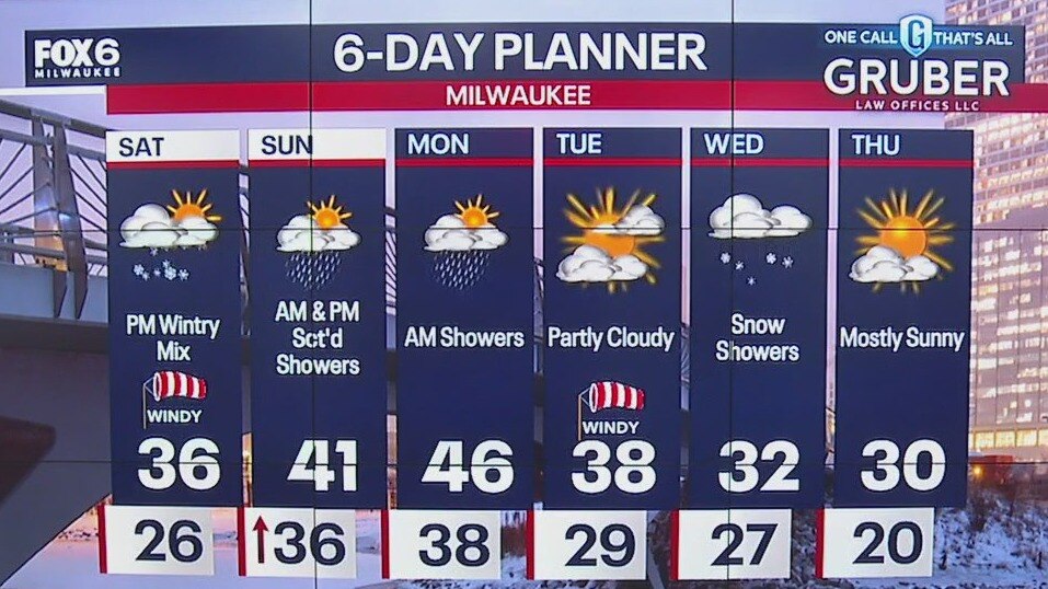
A winter weather advisory is in effect from 3PM Saturday to midnight Sunday. A wintry mix and rain could lead to slippery/icy roads. Not looking to be a problem near the lake due to warmer temps.
A winter weather advisory is in effect from 3PM Saturday to midnight Sunday. A wintry mix and rain could lead to slippery/icy roads. Not looking to be a problem near the lake due to warmer temps.

Weather Webcast with Holly Baker
A wintry mix and warm up in temperatures is expected over the weekend.
A wintry mix and warm up in temperatures is expected over the weekend.