

Milwaukee weather: Rainy, chilly Thursday
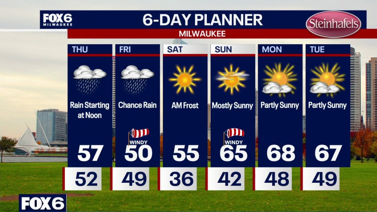
Cloudy skies overnight with temperatures in the 50s. Rain moves in around noon Thursday and really picks up during the afternoon and evening. Highs in the mid-to-upper 50s. Over 1" of rain is expected in many areas. Lighter rain showers continue on Friday with VERY windy conditions. NW winds gusts over 40mph with temperatures struggling to reach 50 for a high.
Cloudy skies overnight with temperatures in the 50s. Rain moves in around noon Thursday and really picks up during the afternoon and evening. Highs in the mid-to-upper 50s. Over 1" of rain is expected in many areas. Lighter rain showers continue on Friday with VERY windy conditions. NW winds gusts over 40mph with temperatures struggling to reach 50 for a high.
Milwaukee weather: Rainy, chilly Thursday
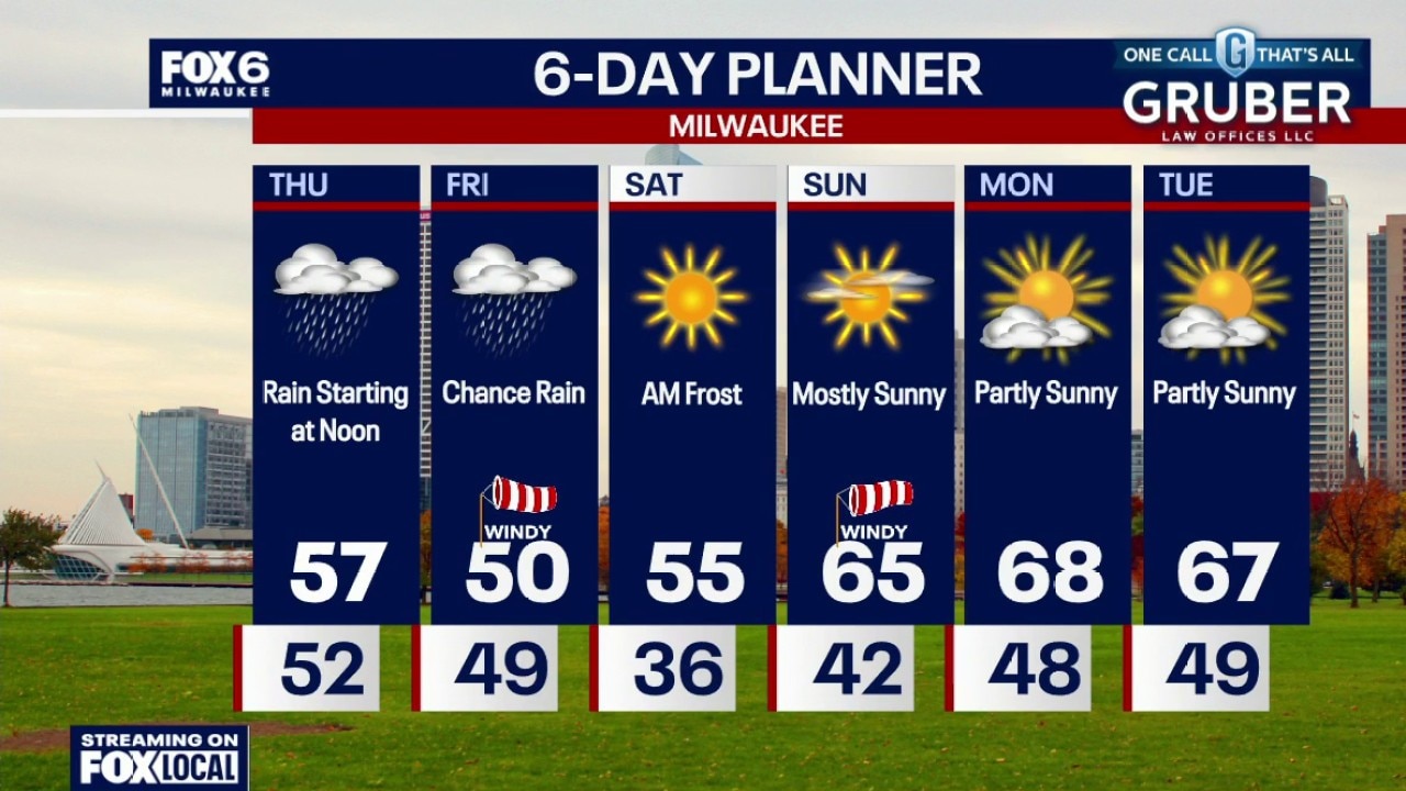
Cloudy skies tonight with temperatures in the 50s. Rain moves in around noon Thursday and really picks up during the afternoon and evening. Highs in the mid-ot-upper 50s. Over 1" of rain is expected in many areas. Lighter rain showers continue on Friday with VERY windy conditions. NW winds gusts over 40mph with temperatures struggling to reach 50 for a high.
Cloudy skies tonight with temperatures in the 50s. Rain moves in around noon Thursday and really picks up during the afternoon and evening. Highs in the mid-ot-upper 50s. Over 1" of rain is expected in many areas. Lighter rain showers continue on Friday with VERY windy conditions. NW winds gusts over 40mph with temperatures struggling to reach 50 for a high.
Milwaukee weather: Rainy Thursday ahead
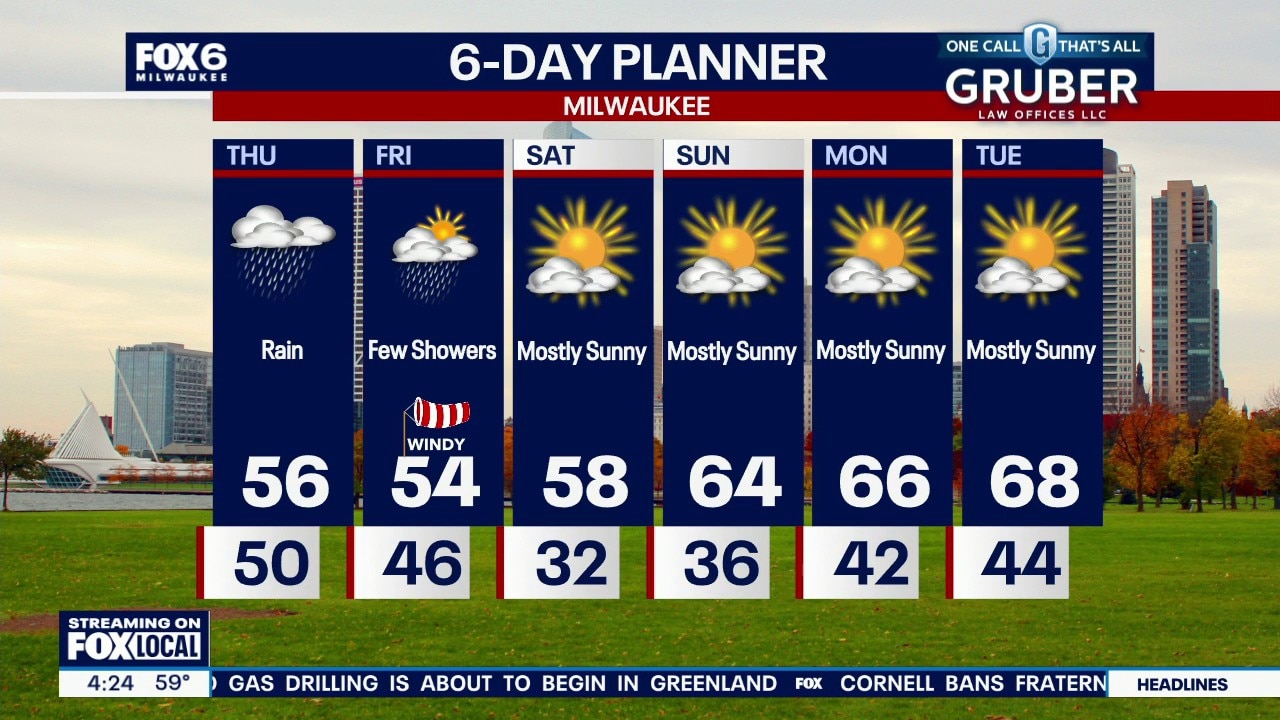
Quiet and cool tonight, then a steady, soaking rain moves in late morning Thursday. It continues through late Thursday night. Scattered showers linger into Friday, plus it will be chilly and very windy.
Quiet and cool tonight, then a steady, soaking rain moves in late morning Thursday. It continues through late Thursday night. Scattered showers linger into Friday, plus it will be chilly and very windy.
Milwaukee weather: Cloudy and cool Wednesday, rain Thursday
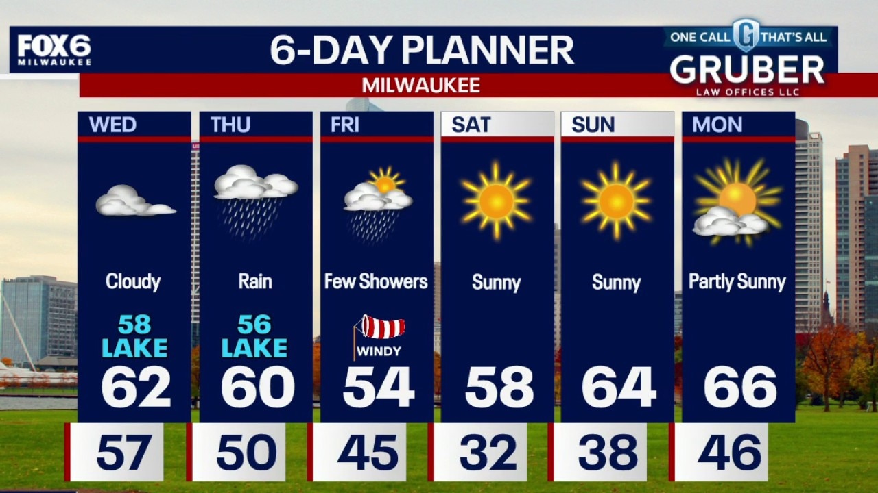
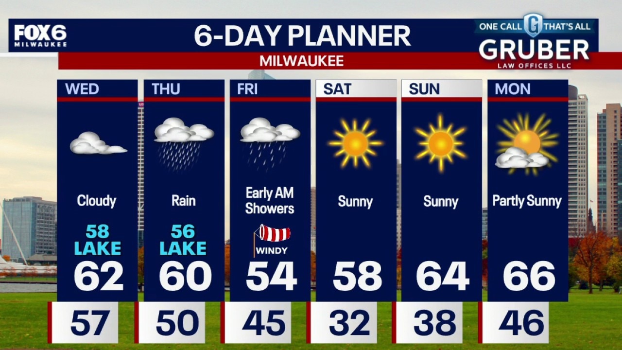
We're trading a relatively quiet Wednesday for a soaking Thursday as a strengthening storm system brings widespread rain to southern Wisconsin. Rain is likely Thursday with the wettest stretch expected from late Thursday morning through Thursday night.
We're trading a relatively quiet Wednesday for a soaking Thursday as a strengthening storm system brings widespread rain to southern Wisconsin. Rain is likely Thursday with the wettest stretch expected from late Thursday morning through Thursday night.
Milwaukee weather: Cloudy and cool Wednesday, rain Thursday
We're trading a relatively quiet Wednesday for a soaking Thursday as a strengthening storm system brings widespread rain to southern Wisconsin.
We're trading a relatively quiet Wednesday for a soaking Thursday as a strengthening storm system brings widespread rain to southern Wisconsin.
Milwaukee weather: Storms end overnight, cooler on Wednesday
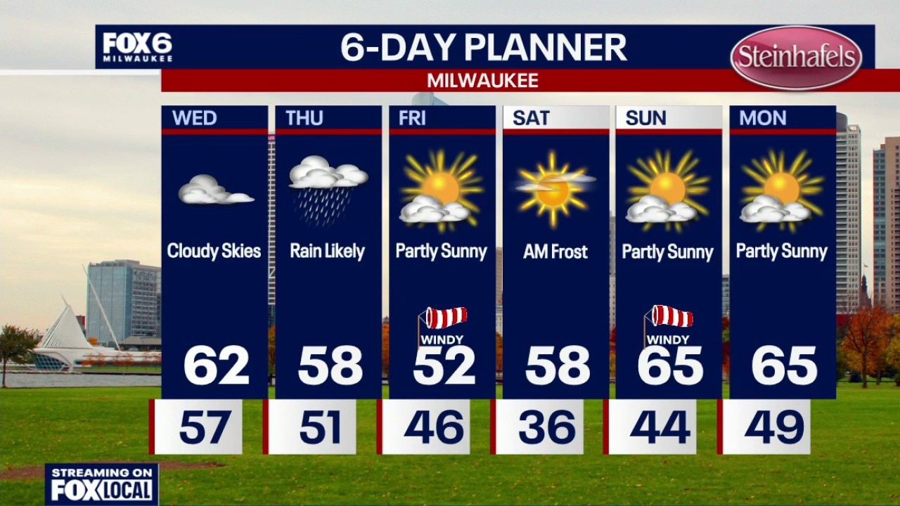
Scattered showers and t-storms will move out overnight. Cloudy skies with temperatures dropping into the 50s by sunrise. Cloudy, breezy and cooler on Wednesday with highs in the low 60s. Rainy and blustery on Thursday, especially by afternoon with highs in the upper 50s. 0.25"-0.50" of rain is expected.
Scattered showers and t-storms will move out overnight. Cloudy skies with temperatures dropping into the 50s by sunrise. Cloudy, breezy and cooler on Wednesday with highs in the low 60s. Rainy and blustery on Thursday, especially by afternoon with highs in the upper 50s. 0.25"-0.50" of rain is expected.
Milwaukee weather: Few showers/storms this evening, cooler on Wednesday
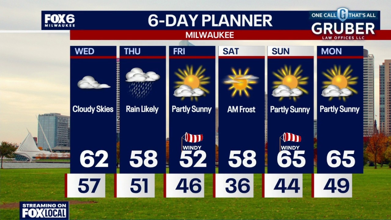
Increasing clouds tonight with a chance for a few showers (and possibly a rumble of thunder) this evening. Temperatures will drop through the 60s and settle in the 50s overnight. Cloudy, breezy and cooler on Wednesday with highs in the low 60s. Rainy and blustery on Thursday, especially by afternoon with highs in the upper 50s. 0.25"-0.50" of rain is expected.
Increasing clouds tonight with a chance for a few showers (and possibly a rumble of thunder) this evening. Temperatures will drop through the 60s and settle in the 50s overnight. Cloudy, breezy and cooler on Wednesday with highs in the low 60s. Rainy and blustery on Thursday, especially by afternoon with highs in the upper 50s. 0.25"-0.50" of rain is expected.
Milwaukee weather: Big changes ahead
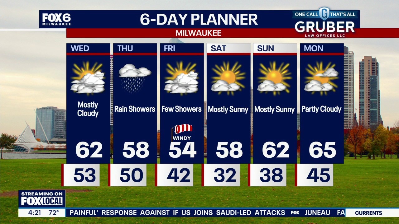
A few showers on the way tonight with an isolated storm possible. Cooler and cloudy on Wednesday then a greater chance of showers on Thursday. Windy and much cooler Friday then a chance of frost/freeze Saturday morning. Gradually warming through next week.
A few showers on the way tonight with an isolated storm possible. Cooler and cloudy on Wednesday then a greater chance of showers on Thursday. Windy and much cooler Friday then a chance of frost/freeze Saturday morning. Gradually warming through next week.
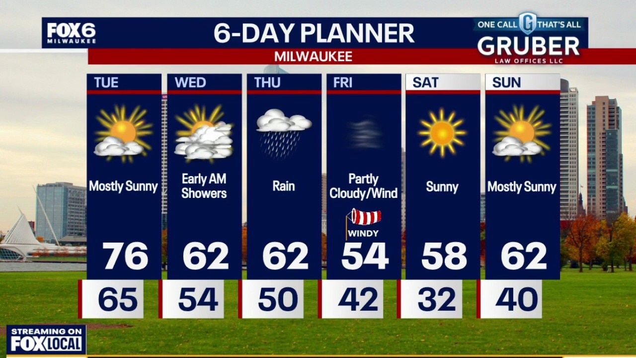
Milwaukee weather: Mild Tuesday, frosty weekend
Enjoy the 70s while they last because Mother Nature is about to remind us that it's October in Wisconsin!
Enjoy the 70s while they last because Mother Nature is about to remind us that it's October in Wisconsin!
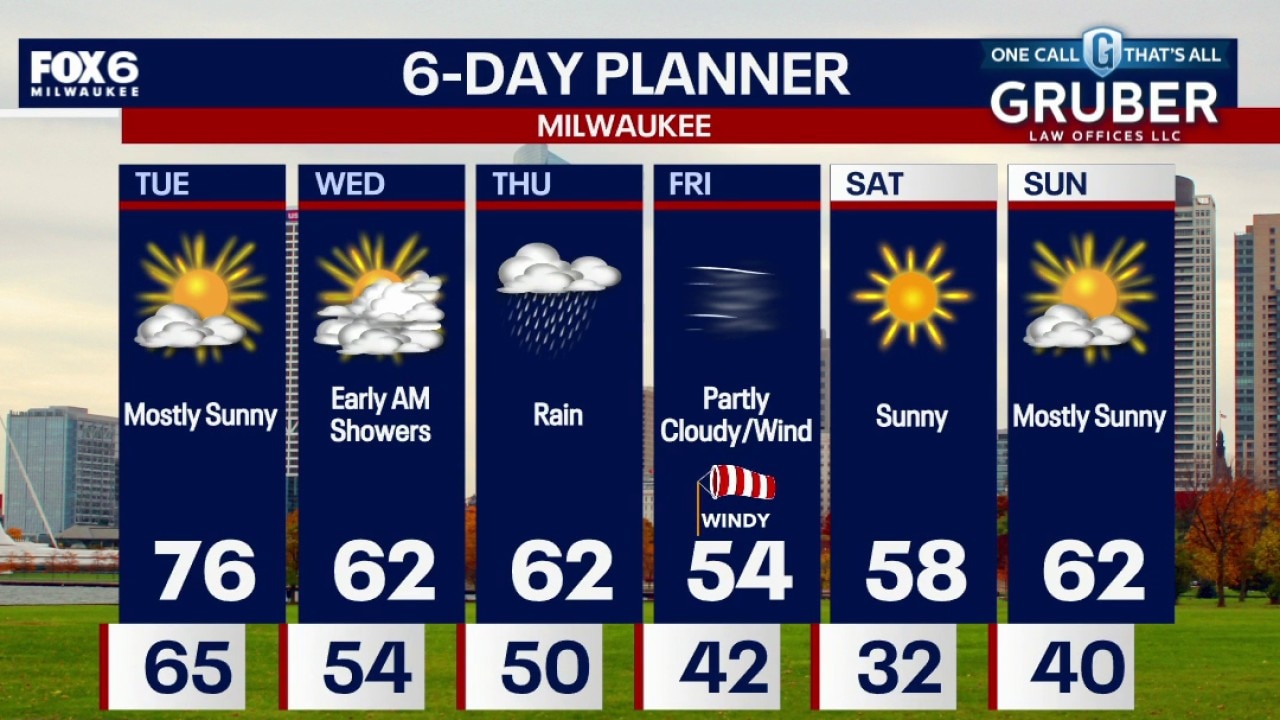
Milwaukee weather: Mild Tuesday, frosty weekend
Enjoy the 70s while they last because Mother Nature is about to remind us that it's October in Wisconsin! Tuesday brings plenty of sunshine and a gusty breeze, but showers and a few thunderstorms could sneak into southern Wisconsin Tuesday night, mainly near the Illinois border.
Enjoy the 70s while they last because Mother Nature is about to remind us that it's October in Wisconsin! Tuesday brings plenty of sunshine and a gusty breeze, but showers and a few thunderstorms could sneak into southern Wisconsin Tuesday night, mainly near the Illinois border.
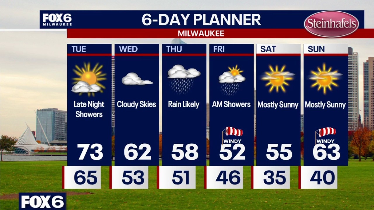
Milwaukee weather: Record 80s today to 50s late week
Partly cloudy overnight and breezy. Temperatures will drop through the 70s and settle in the 60s by sunrise. Partly sunny on Tuesday with highs in the low 70s. A few showers are possible late Tuesday night. Cloudy and cooler on Wednesday with highs in the low 60s. Rainy on Thursday with highs in the upper 50s.
Partly cloudy overnight and breezy. Temperatures will drop through the 70s and settle in the 60s by sunrise. Partly sunny on Tuesday with highs in the low 70s. A few showers are possible late Tuesday night. Cloudy and cooler on Wednesday with highs in the low 60s. Rainy on Thursday with highs in the upper 50s.
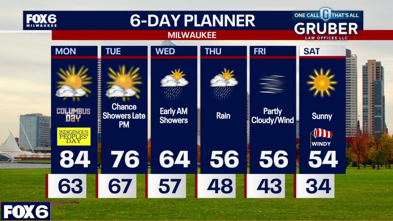
Milwaukee weather: Partly Sunny, Warm, Chance of Showers
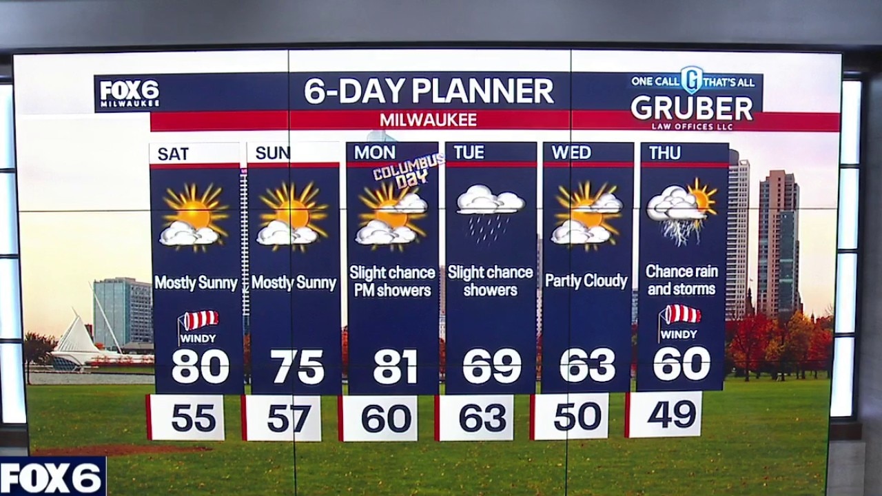
Columbus Day is feeling more like the Fourth of July, with highs soaring into the low to mid-80s and potentially challenging a few records
Columbus Day is feeling more like the Fourth of July, with highs soaring into the low to mid-80s and potentially challenging a few records
Milwaukee weather: Record High on Monday
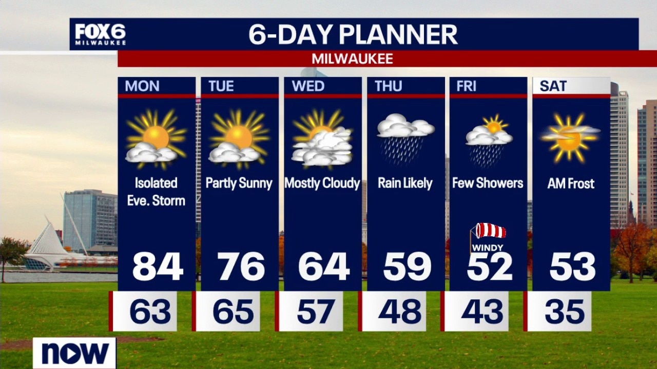
A few clouds overnight with temperatures settling in the upper 50s to low 60s by sunrise. A Record High is forecast on Monday. Partly sunny, breezy and warm with a high of 84 (current record is 83 in 1995). An isolated evening t-storms is possible. Partly sunny, breezy and still warm on Tuesday with highs in the mid-70s. Mostly cloudy and cooler on Wednesday with highs in the 60s.
A few clouds overnight with temperatures settling in the upper 50s to low 60s by sunrise. A Record High is forecast on Monday. Partly sunny, breezy and warm with a high of 84 (current record is 83 in 1995). An isolated evening t-storms is possible. Partly sunny, breezy and still warm on Tuesday with highs in the mid-70s. Mostly cloudy and cooler on Wednesday with highs in the 60s.
Milwaukee weather: Record High on Monday
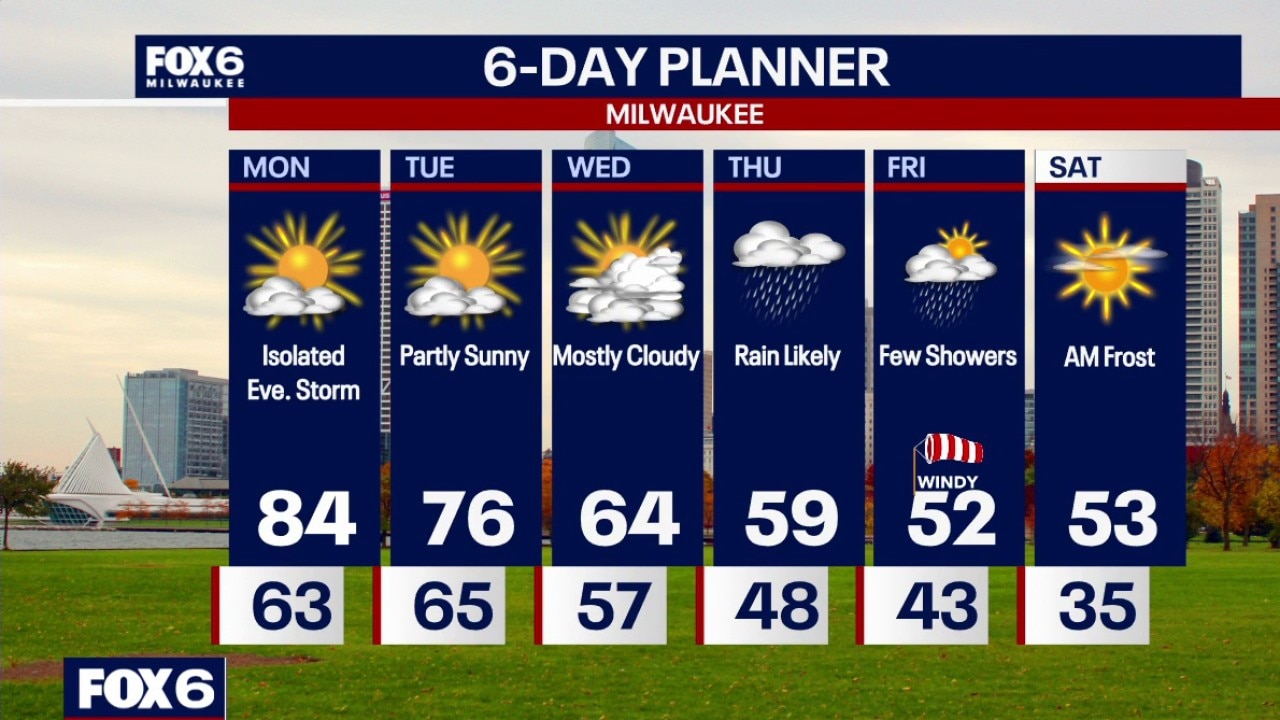
A few clouds tonight with temperatures dropping through the 60s and settling in the low 60s by sunrise. A Record High is forecast on Monday. Partly sunny, breezy and warm with a high of 84 (current record is 83 in 1995). An isolated evening t-storms is possible. Partly sunny, breezy and still warm on Tuesday with highs in the mid-70s. Mostly cloudy and cooler on Wednesday with highs in the 60s.
A few clouds tonight with temperatures dropping through the 60s and settling in the low 60s by sunrise. A Record High is forecast on Monday. Partly sunny, breezy and warm with a high of 84 (current record is 83 in 1995). An isolated evening t-storms is possible. Partly sunny, breezy and still warm on Tuesday with highs in the mid-70s. Mostly cloudy and cooler on Wednesday with highs in the 60s.
Milwaukee weather: Sunny Sunday!
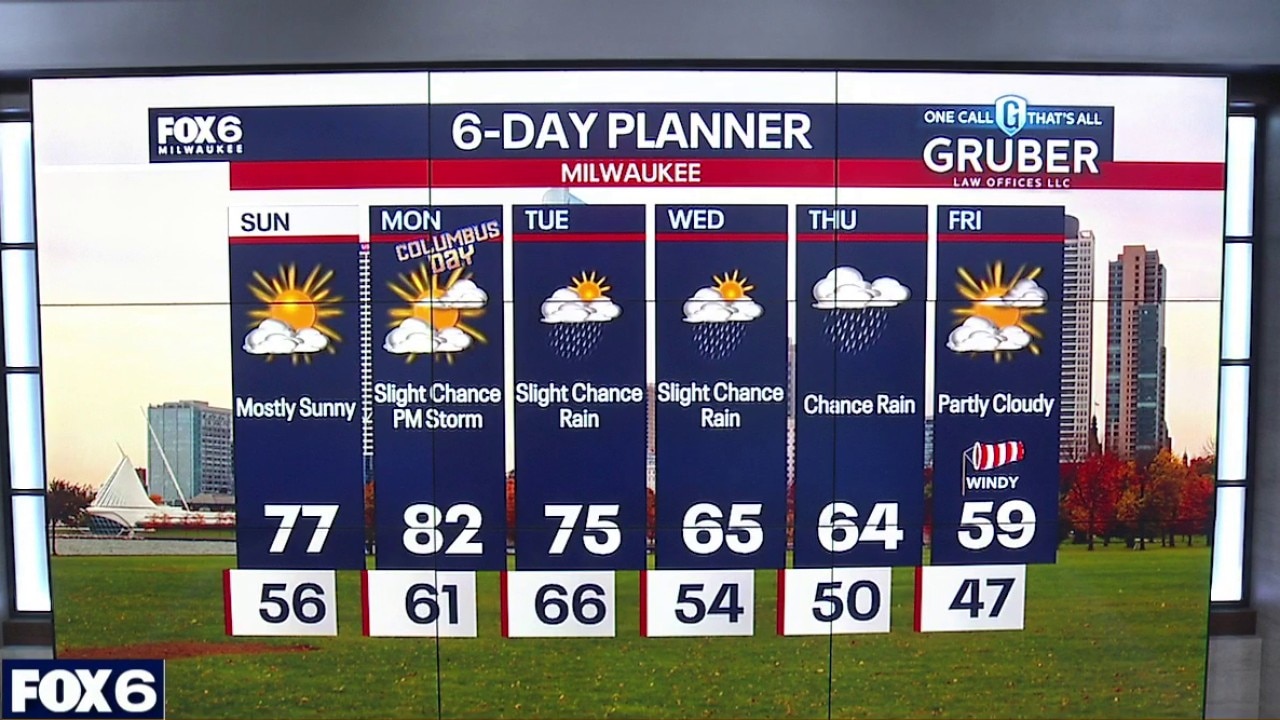
Sunny to mostly sunny Sunday with highs in the mid to upper 70s. Cooler near the lake. Mostly clear tonight with temps in the upper 50s to low 60s.
Sunny to mostly sunny Sunday with highs in the mid to upper 70s. Cooler near the lake. Mostly clear tonight with temps in the upper 50s to low 60s.
Milwaukee weather: Beautiful weather is on the way.
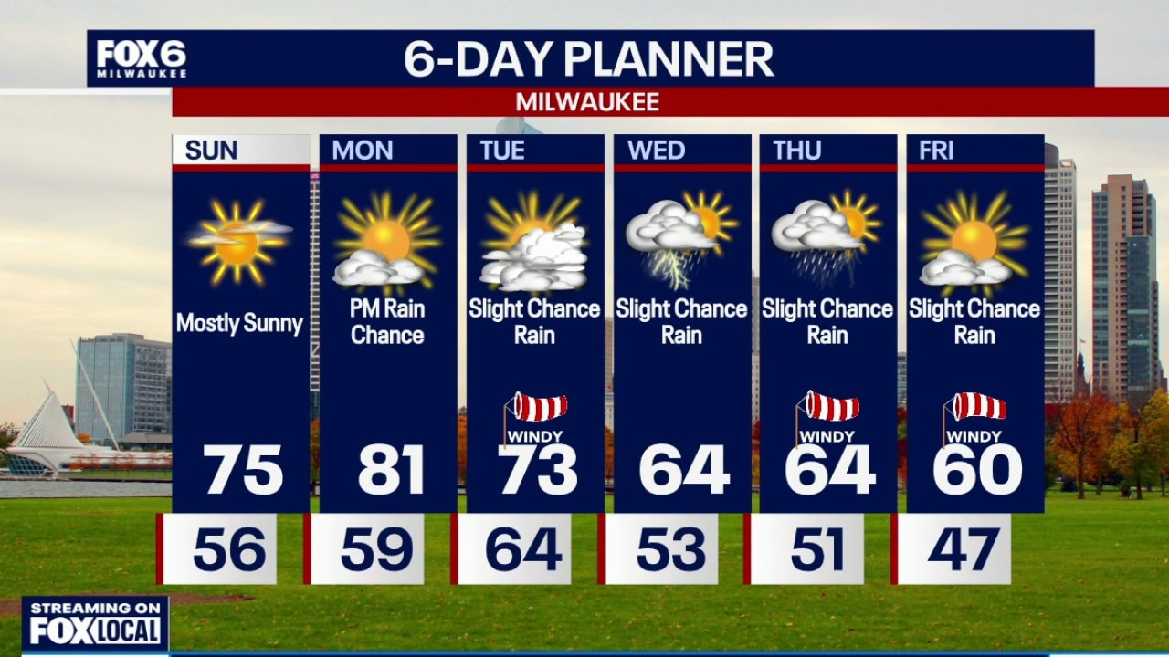
Another summerlike day will be on the way for Sunday before changes arrives next week.
Another summerlike day will be on the way for Sunday before changes arrives next week.
Milwaukee weather: Summer-like Saturday!
Starting off sunny on Saturday. High clouds from Isaias will move in by the afternoon. Breezy with highs near 80F. Partly cloudy Saturday night with lows in the upper 50s. Winds will become lighter out of the south.
Starting off sunny on Saturday. High clouds from Isaias will move in by the afternoon. Breezy with highs near 80F. Partly cloudy Saturday night with lows in the upper 50s. Winds will become lighter out of the south.
Milwaukee weather: PM Showers, 80s Saturday
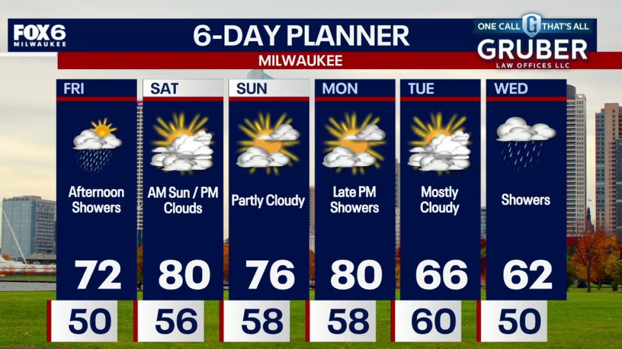
October is apparently taking a little vacation, with temperatures climbing into summer territory this weekend! First, we'll have to dodge a few showers and possibly a thunderstorm Friday.
October is apparently taking a little vacation, with temperatures climbing into summer territory this weekend! First, we'll have to dodge a few showers and possibly a thunderstorm Friday.
Milwaukee weather: PM Showers, 80s Saturday
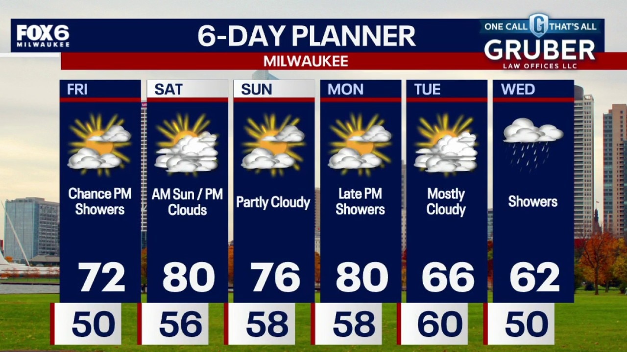
October is apparently taking a little vacation, with temperatures climbing into summer territory this weekend! First, we'll have to dodge a few showers and possibly a thunderstorm Friday.
October is apparently taking a little vacation, with temperatures climbing into summer territory this weekend! First, we'll have to dodge a few showers and possibly a thunderstorm Friday.
Milwaukee weather: Few PM showers Friday, big weekend warm up
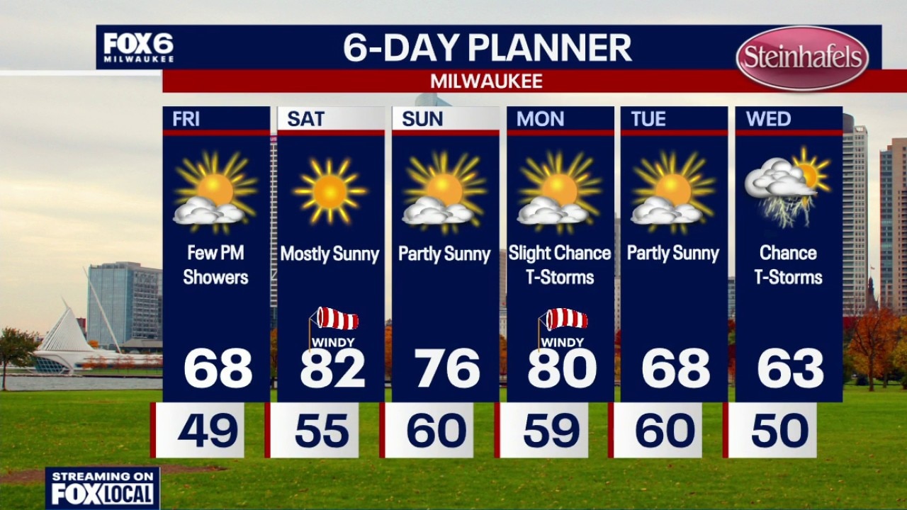
A few clouds overnight with temperatures settling in the 40s by sunrise. Partly sunny on Friday with highs in the upper 60s. A few afternoon/early evening light rain showers are possible. Mostly sunny, windy and hot for this time of year on Saturday. Highs in the low 80s with a gusty SW wind.
A few clouds overnight with temperatures settling in the 40s by sunrise. Partly sunny on Friday with highs in the upper 60s. A few afternoon/early evening light rain showers are possible. Mostly sunny, windy and hot for this time of year on Saturday. Highs in the low 80s with a gusty SW wind.