

Southern Wisconsin weather: Gusty winds, first freeze possible Friday
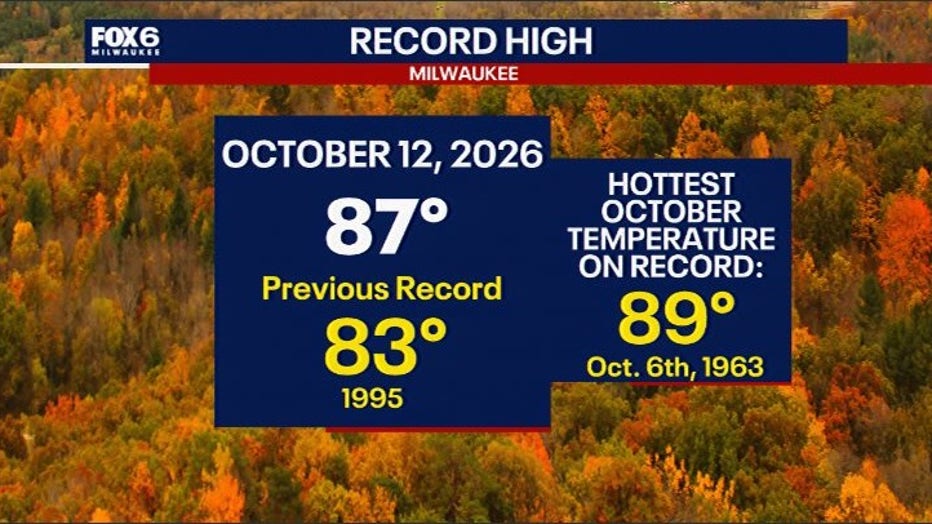
MILWAUKEE - After breaking a record on Monday, Oct. 12, and sitting in the 70s for much of Tuesday, Southern Wisconsin is about to get a serious reality check.
Big temperature drop
The Details:
A powerful cold front arriving late Thursday into Friday will usher in gusty winds, pushing much colder air into the area with the possibility of widespread frost and even some below-freezing temperatures by the weekend.
While forecast models still vary quite a bit, Friday night into Saturday morning presents the greatest risk of frost, with another round possible Saturday night into Sunday morning in some inland areas.
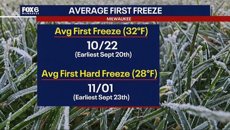
This chill is a bit ahead of schedule as compared to climate averages.
While it is a bit early, it is not that unusual to have a frost or freeze in mid-October. As recently as 2018, we had a first freeze on the 13th of the month.
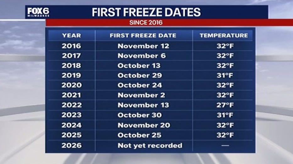
For gardeners and anyone still trying to squeeze a few more weeks out of the growing season, this is your heads-up. It may be time to start bringing those sensitive plants indoors.
From the 80s to the 30s in just a few days
By the numbers:
Monday hit a record high of 87 degrees and Tuesday's temperatures are in the 70s. However, a developing storm system will bring widespread rain Thursday into Thursday night, and behind the departing storm, much colder Canadian air will spill into Wisconsin.
Very strong northwest winds could gust between 30 and 40 mph late Thursday night through Friday afternoon, making the transition to colder weather especially rapid and more noticeable.
By Saturday, afternoon temperatures are expected to climb into the 50s, a significant change from the early-week warmth. Inland areas will cool into the 30s Saturday night into Sunday morning.
The greatest frost and freeze risk comes Friday night
Timeline:
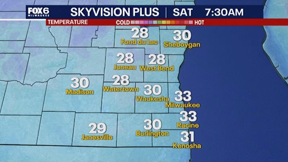
The rapid chill begins after sunset Friday as high pressure moves into the region behind the strong cold front. The strong wind that ushered in the colder air will diminish rapidly and skies will clear. That combination creates near perfect conditions for temperatures to drop overnight.
While areas near Lake Michigan may get some moderation and city center areas benefit from residual urban heat, inland lows in the upper 20s and low 30s are expected by early Saturday morning, meaning a frost or freeze is likely.
The difference between frost and a freeze is important:
- Frost: Ice crystals can form on exposed surfaces when temperatures at the ground level drop to freezing, even if the official air temperature, which is typically taken at around 5 feet, remains above 32 degrees.
- Freeze: Air temperatures reach 32 degrees or lower, potentially damaging or killing sensitive vegetation.
- Hard freeze: Temperatures generally fall to 28 degrees or colder for an extended period, bringing a greater risk of widespread damage to plants.
While widespread freezing temperatures or a hard freeze are not yet a certainty, the forecast trends do suggest a growing risk that many locations could experience their first damaging cold of the season.
Saturday will bring some sunshine and highs in the 50s, but the cold won't be finished. Temperatures are expected to fall back into the 30s Saturday night into Sunday morning, creating another opportunity for frost development. However, Saturday night should be a few degrees warmer than Friday night as winds gradually turn southerly and begin bringing milder air back into the region. A gradual warming trend is expected early next week, with daytime highs returning to the 60s.
What gardeners and flower lovers should do
What you can do:

If you've managed to keep your flowers, late-season vegetables and outdoor plants thriving this far into October, a little preparation could help extend their season.
- Bring sensitive plants indoors: Potted flowers, tropical plants and tender herbs should be moved inside or into a protected area before Friday evening.
- Cover vulnerable vegetation: Use frost cloths, lightweight blankets or sheets to protect outdoor plants. Avoid placing plastic directly against leaves.
- Pay attention to low-lying areas: Cold air tends to settle in valleys and sheltered locations, where temperatures can fall lower than surrounding areas.
- Watch for updated forecasts: Small changes in cloud cover and wind speeds could determine whether a location experiences frost, freezing temperatures or neither.
The bottom line
Dig deeper:
Southern Wisconsin is heading toward one of its coldest stretches of the fall so far, with a sharp temperature drop following Thursday's rain.
Friday will be windy and chilly, but the real concern comes Friday night when clearing skies and lighter winds could allow temperatures to fall into the lower 30s in some areas.
Frost appears likely Friday night, with a localized freeze possible. Another round of frost could develop Saturday night before temperatures begin recovering early next week. The growing season may be running out of time, but whether this cold snap delivers the final blow will depend on just how low those overnight temperatures fall and how well you prepare.
The Source: Information in this post was provided by the FOX6 Weather Experts and the National Weather Service.