


Southeast Wisconsin lake effect snow; messy Monday commute expected
A winter weather advisory has been issued for Milwaukee, Racine and Kenosha counties to be in effect until 4 p.m. on Monday, Jan. 6.
A winter weather advisory has been issued for Milwaukee, Racine and Kenosha counties to be in effect until 4 p.m. on Monday, Jan. 6.


Milwaukee DPW: Roadways treated, crews on standby for lake-effect snow
The Milwaukee Department of Public Works (DPW) says its road crews are ready to take action should lake-effect snow begin to fall in earnest in the city on Monday, Jan. 6.
The Milwaukee Department of Public Works (DPW) says its road crews are ready to take action should lake-effect snow begin to fall in earnest in the city on Monday, Jan. 6.
Weather webcast with Rob Haswell
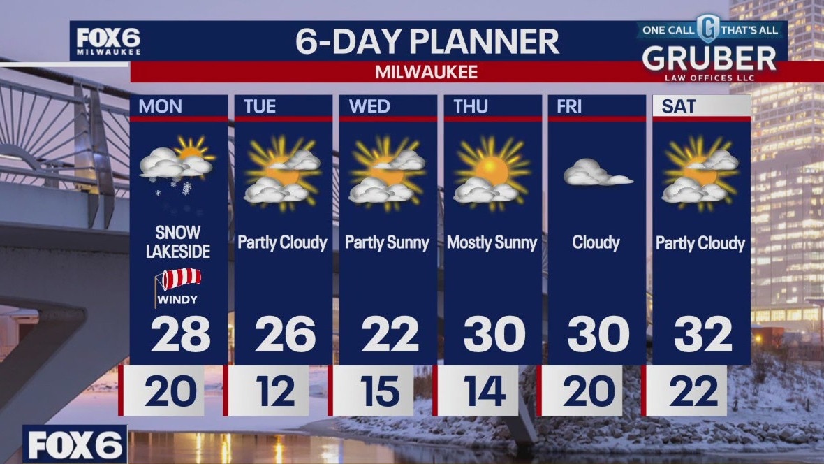
A Winter Weather Advisory is in place for Milwaukee, Racine and Kenosha counties until 4pm. Several inches of snow are possible lakeside in those areas. Areas away from Lake Michigan can expect a windy and cloudy day with highs in the upper 20s.
A Winter Weather Advisory is in place for Milwaukee, Racine and Kenosha counties until 4pm. Several inches of snow are possible lakeside in those areas. Areas away from Lake Michigan can expect a windy and cloudy day with highs in the upper 20s.
Weather Webcast with Chief Meteorologist Tom Wachs
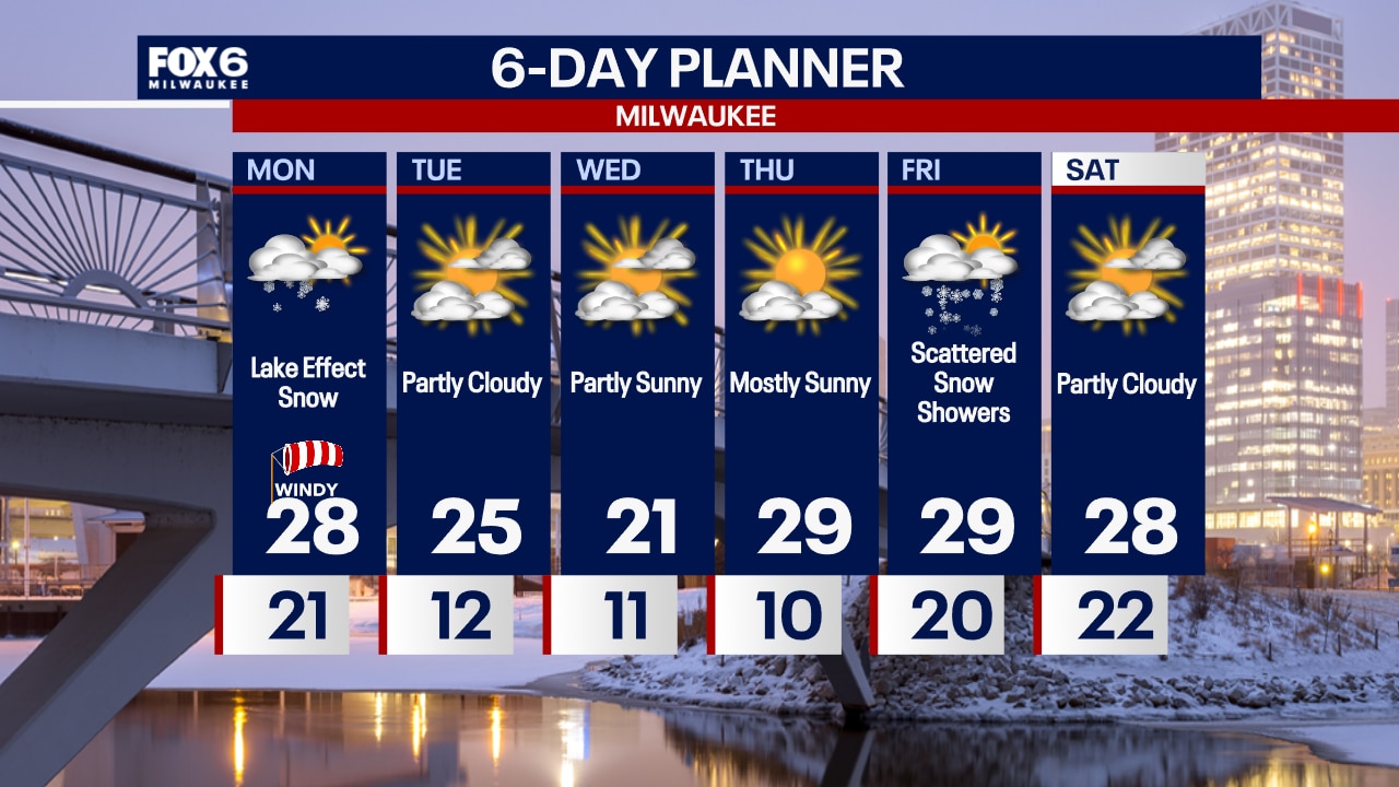
A lake effect snow band will develop overnight and continue until mid-afternoon Monday in Racine and Kenosha counties. There is some question as to whether the heavy snow band will push west into Milwaukee. Please stay up to date with the forecast on Monday.
A lake effect snow band will develop overnight and continue until mid-afternoon Monday in Racine and Kenosha counties. There is some question as to whether the heavy snow band will push west into Milwaukee. Please stay up to date with the forecast on Monday.

Weather Webcast with Chief Meteorologist Tom Wachs
A narrow band of lake effect snow will develop in Racine and Kenosha later this evening and continue through Monday afternoon. Little snow outside of that band. But over 4" is possible in Racine and Kenosha later tonight & Monday.
A narrow band of lake effect snow will develop in Racine and Kenosha later this evening and continue through Monday afternoon. Little snow outside of that band. But over 4" is possible in Racine and Kenosha later tonight & Monday.

Weather webcast with Lisa Michaels
Partly sunny skies on Sunday with high temps in the low 20s. Wind chills in the single digits to low teens. Clouds increase late Sunday afternoon.
Partly sunny skies on Sunday with high temps in the low 20s. Wind chills in the single digits to low teens. Clouds increase late Sunday afternoon.

Weather Webcast with Holly Baker
Cold temperatures continue with lake effect snow not too far away!
Cold temperatures continue with lake effect snow not too far away!


Kansas City Chiefs’ depart after ice storm strands them for hours on runway
The Kansas City Chiefs were stranded for hours Saturday at Kansas City International Airport as an ice storm shut down operations.
The Kansas City Chiefs were stranded for hours Saturday at Kansas City International Airport as an ice storm shut down operations.


Safety tips for shoveling snow
Shoveling snow is an unavoidable chore for some people, but if you’re not careful, you could end up seriously injured, or worse.
Shoveling snow is an unavoidable chore for some people, but if you’re not careful, you could end up seriously injured, or worse.

Weather webcast with Lisa Michaels
A very cold start to Saturday morning with wind chills ranging from -5? to -15? below zero. Mostly sunny during the day with highs temps in the upper teens but wind chills -5? to 5?. Partly sunny and still cold on Sunday with highs in the low 20s. A big low pressure system will stay south of Wisconsin Sunday, but as it moves east, winds will transition off of the lake and could bring lake effect snow late Sunday night into early Monday morning. Accumulating snowfall is possible. Sub-freezing high temperatures remain in the forecast for the rest of the week which is 5 to 10 degrees below average for this time of year.
A very cold start to Saturday morning with wind chills ranging from -5? to -15? below zero. Mostly sunny during the day with highs temps in the upper teens but wind chills -5? to 5?. Partly sunny and still cold on Sunday with highs in the low 20s. A big low pressure system will stay south of Wisconsin Sunday, but as it moves east, winds will transition off of the lake and could bring lake effect snow late Sunday night into early Monday morning. Accumulating snowfall is possible. Sub-freezing high temperatures remain in the forecast for the rest of the week which is 5 to 10 degrees below average for this time of year.

Webcast Weather with Holly Baker
Polar air sticks around for a few days.
Polar air sticks around for a few days.


How to prep your house for freezing weather
Keeping gutters clean and clearing any dead or possibly dangerous tree branches can significantly help prevent any costly damages to your home.
Keeping gutters clean and clearing any dead or possibly dangerous tree branches can significantly help prevent any costly damages to your home.


How cold does it have to be to get frostbite?
Wind and cold temperatures can cause frostbite in minutes, especially in areas like your fingers and toes. Here’s what to know.
Wind and cold temperatures can cause frostbite in minutes, especially in areas like your fingers and toes. Here’s what to know.
Weather Webcast with Stephanie Barichello
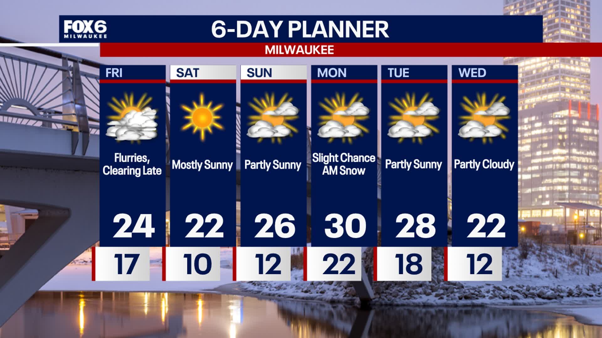
Flurries linger through mid-afternoon then decreasing clouds. It'll be windy and colder with temperatures in the 20s and wind chills in the single digits. Similar conditions on Saturday but more sunshine. A storm system with snow and ice stays south, keeping SE WI dry through next week. There is only a slight chance for lake-effect snow on Monday.
Flurries linger through mid-afternoon then decreasing clouds. It'll be windy and colder with temperatures in the 20s and wind chills in the single digits. Similar conditions on Saturday but more sunshine. A storm system with snow and ice stays south, keeping SE WI dry through next week. There is only a slight chance for lake-effect snow on Monday.


How much ice does it take to knock out power, damage trees?
While it only takes a thin coating of ice to cause travel nightmares for motorists, it takes a heavier accretion of ice to damage trees and power lines, and the severity of the damage depends on how much weight is added by the ice.
While it only takes a thin coating of ice to cause travel nightmares for motorists, it takes a heavier accretion of ice to damage trees and power lines, and the severity of the damage depends on how much weight is added by the ice.
Weather webcast with Rob Haswell
High pressure ushers in a chilly air mass today with highs in the low to mid 20s and feeling colder with a breezy NW wind. Clear conditions overnight will allow for significant cooling. Lows will dip into the single digits inland with wind chill readings -10 to -15 at times. A cold but mostly sunny weekend on tap. Light snow is possible late Sunday into early Monday. We stay cold well into next week.
High pressure ushers in a chilly air mass today with highs in the low to mid 20s and feeling colder with a breezy NW wind. Clear conditions overnight will allow for significant cooling. Lows will dip into the single digits inland with wind chill readings -10 to -15 at times. A cold but mostly sunny weekend on tap. Light snow is possible late Sunday into early Monday. We stay cold well into next week.
Weather Webcast with Chief Meteorologist Tom Wachs
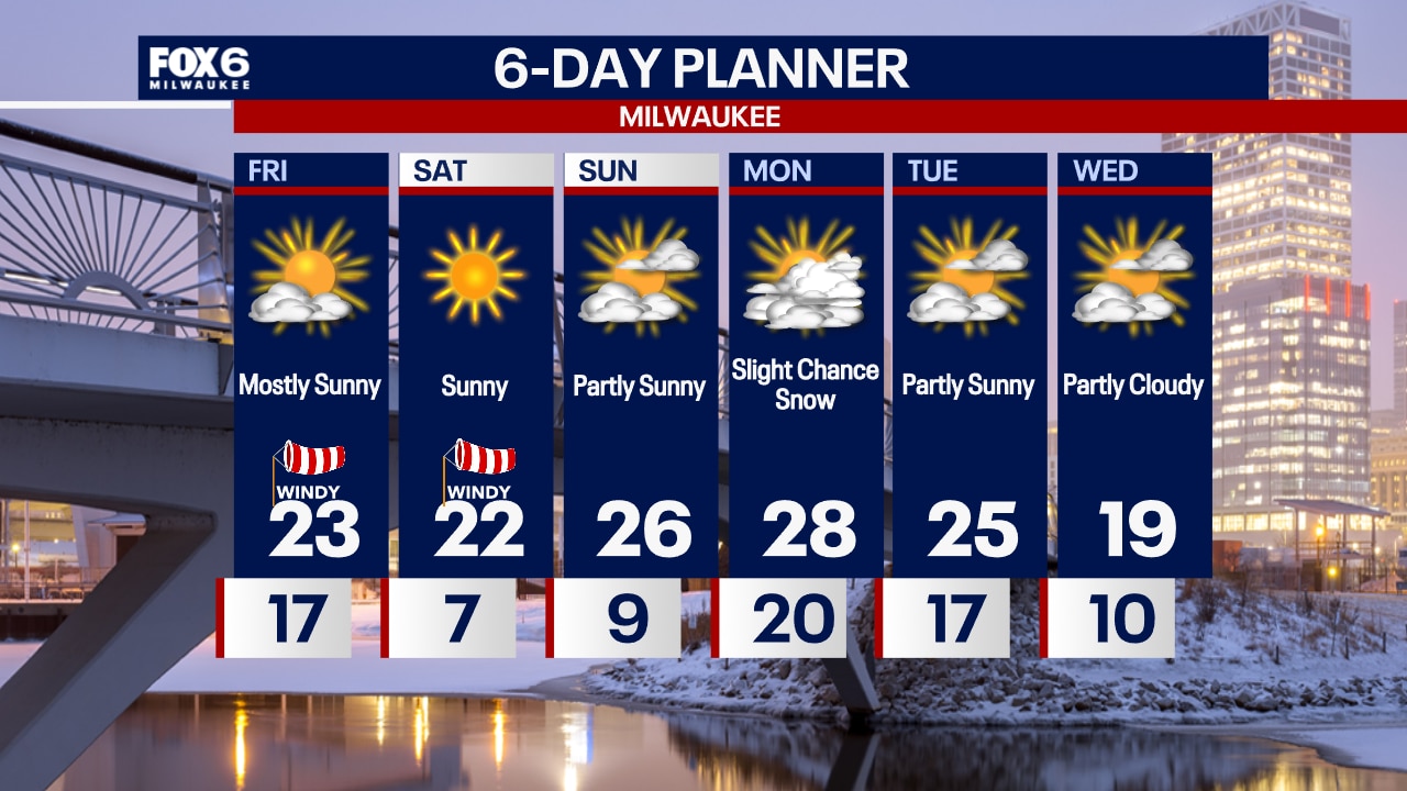
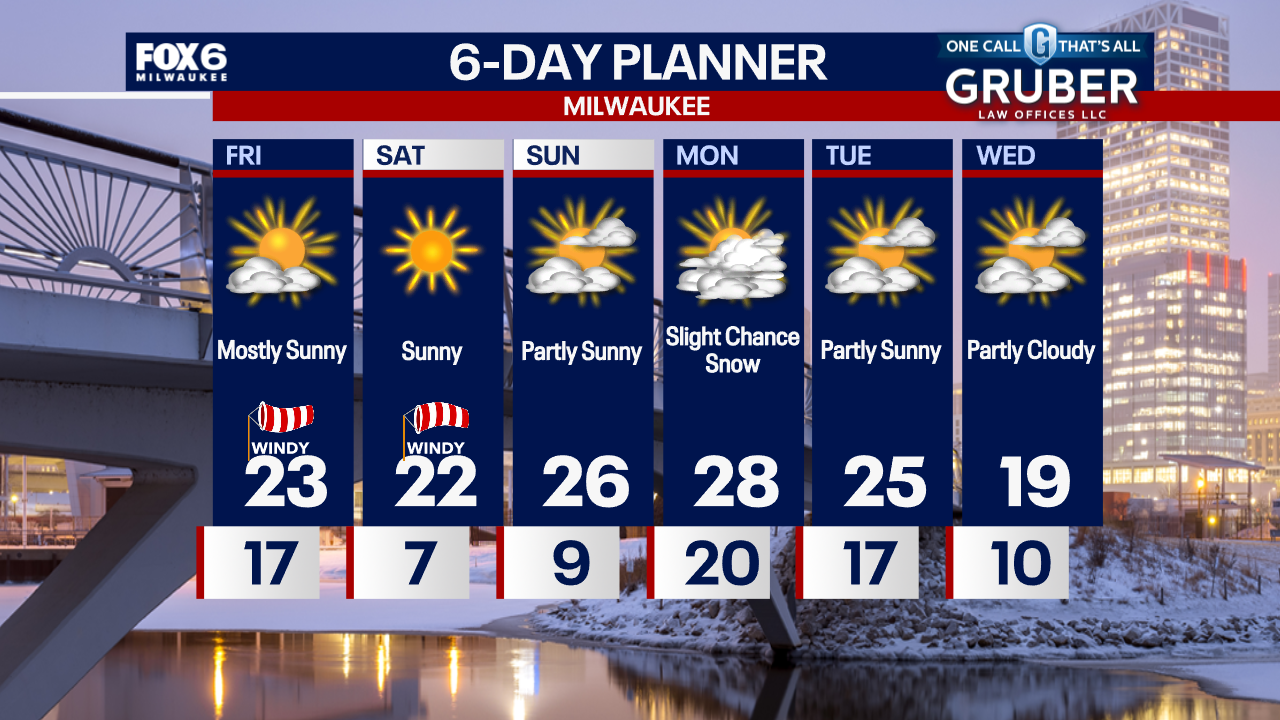
A few flurries overnight with temperatures falling into the teens. Mostly sunny and windy on Friday with highs in the low 20s and wind chills in the teens all day.
A few flurries overnight with temperatures falling into the teens. Mostly sunny and windy on Friday with highs in the low 20s and wind chills in the teens all day.
Weather Webcast with Chief Meteorologist Tom Wachs
Partly cloudy tonight with temperatures dropping into the teens overnight. Mostly sunny and chilly on Friday with wind chills in the single digits all day.
Partly cloudy tonight with temperatures dropping into the teens overnight. Mostly sunny and chilly on Friday with wind chills in the single digits all day.
Weather Webcast with Stephanie Barichello
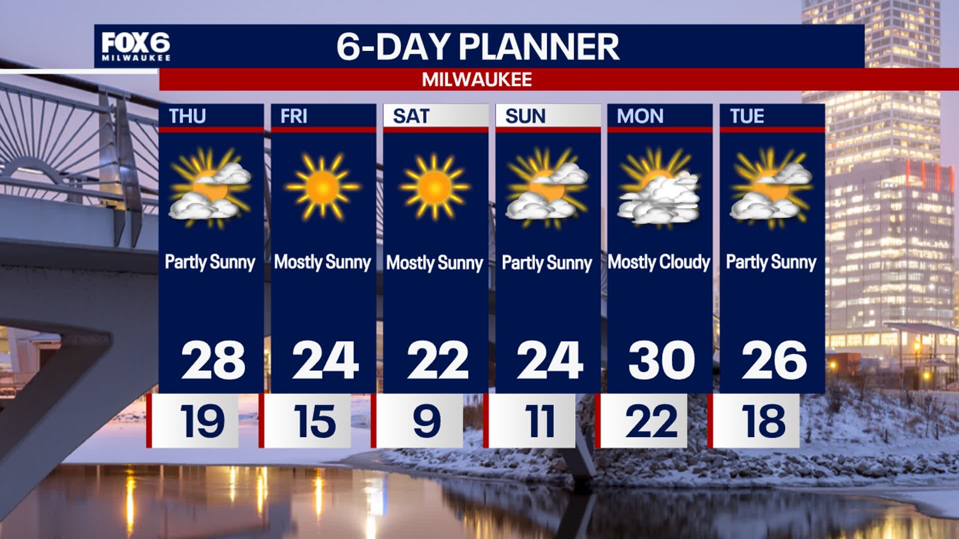
A few more clouds this afternoon thanks to snow passing south of us in IL. Temperatures remain in the middle and upper 20s. Dropping into the teens tonight then only low 20s Friday afternoon, but expect more sunshine. Similar conditions ahead this weekend.
A few more clouds this afternoon thanks to snow passing south of us in IL. Temperatures remain in the middle and upper 20s. Dropping into the teens tonight then only low 20s Friday afternoon, but expect more sunshine. Similar conditions ahead this weekend.

Weather webcast with Rob Haswell
Cooler air dominates our forecast for a few days. The high pressure ridge to our north helps push more active weather south. Other than a few flurries this morning, we are relatively precipitation free through the end of the week as a low passes through Illinois into Indiana. We stay cold through the longer range with each day being a few degrees below average. Extended range outlooks also remain cool with the 8-14 day temperature trend leaning toward cooler conditions through mid month.
Cooler air dominates our forecast for a few days. The high pressure ridge to our north helps push more active weather south. Other than a few flurries this morning, we are relatively precipitation free through the end of the week as a low passes through Illinois into Indiana. We stay cold through the longer range with each day being a few degrees below average. Extended range outlooks also remain cool with the 8-14 day temperature trend leaning toward cooler conditions through mid month.