

Weather Webcast with Holly Baker
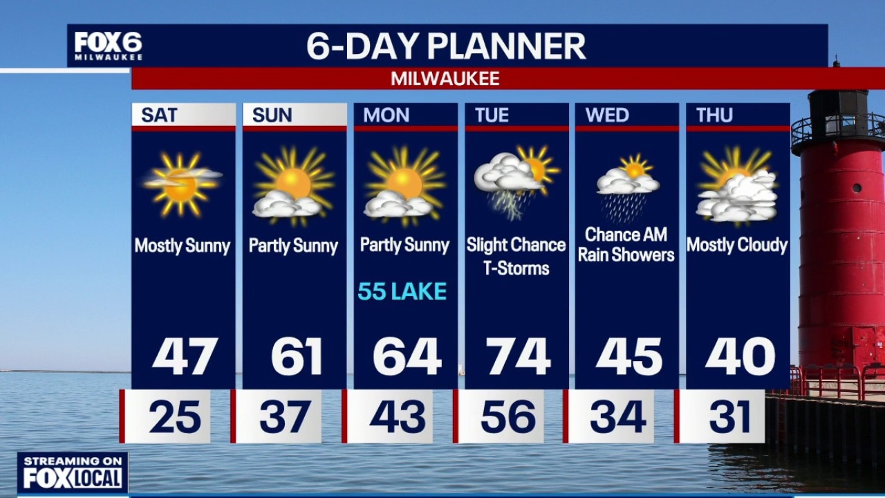
Warmer temperatures are on the way for the next few days.
Warmer temperatures are on the way for the next few days.
Weather Webcast with Holly Baker
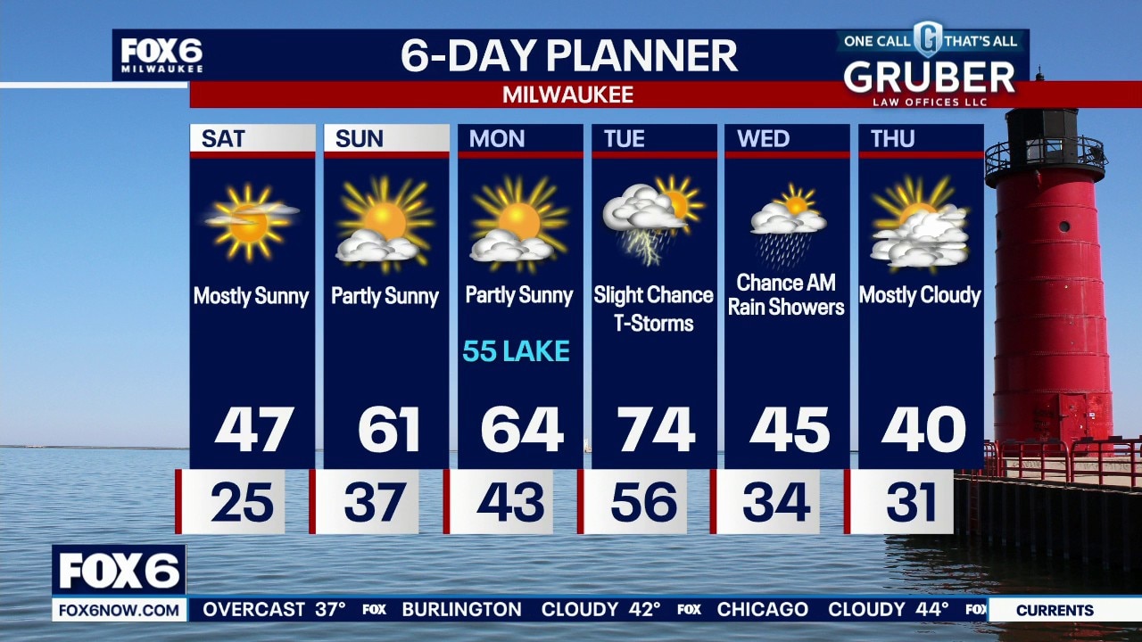
Warmer temperatures over the weekend and next week.
Warmer temperatures over the weekend and next week.
Weather webcast with Stephanie Barichello
A windy and chilly start to the day, and staying cool into the afternoon with temperatures around 40. There is a chance for a few flurries at times.
A windy and chilly start to the day, and staying cool into the afternoon with temperatures around 40. There is a chance for a few flurries at times.
Weather Webcast with Holly Baker
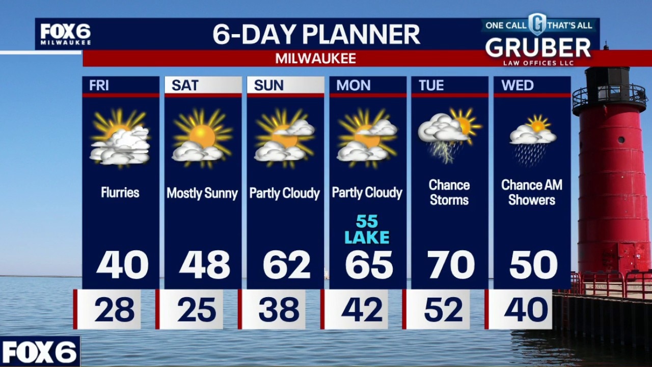
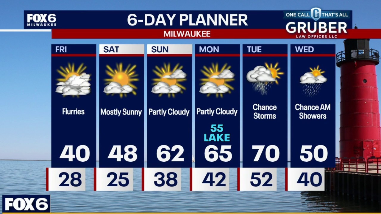
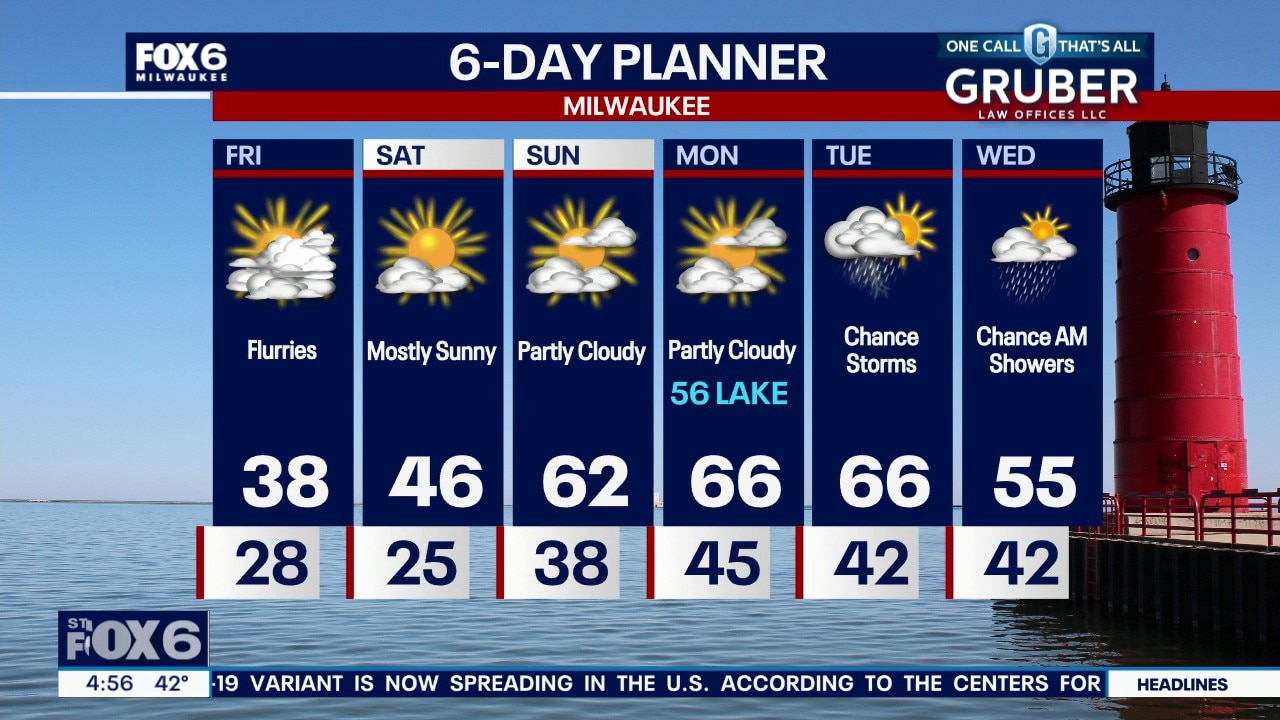
Cooler temperatures for Friday.
Cooler temperatures for Friday.
Weather Webcast with Stephanie Barichello
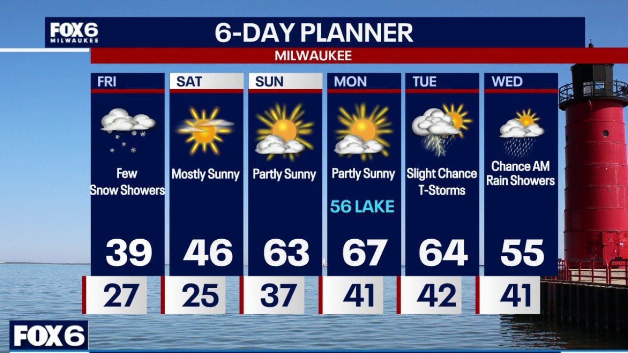
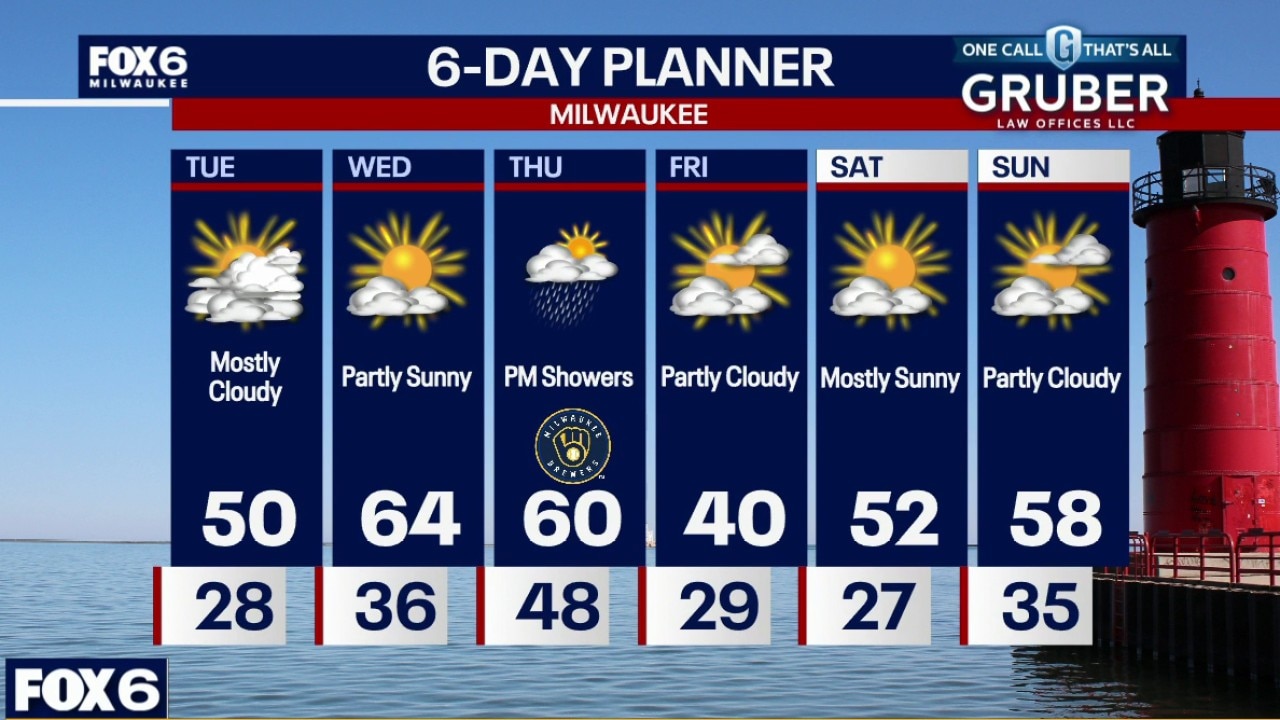
Rain showers end after 10pm then drying out overnight with lows in the upper 20s. Flurries possible Friday along with chilly temperatures, then gradually warming over the weekend. Watching a few storm systems next week.
Rain showers end after 10pm then drying out overnight with lows in the upper 20s. Flurries possible Friday along with chilly temperatures, then gradually warming over the weekend. Watching a few storm systems next week.
Weather webcast with Rob Haswell
Gusty northeast winds will be the main story Thursday, especially along the lakeshore from Milwaukee to Kenosha, where conditions will feel raw and blustery.
Gusty northeast winds will be the main story Thursday, especially along the lakeshore from Milwaukee to Kenosha, where conditions will feel raw and blustery.
Weather Webcast with Chief Meteorologist Tom Wachs
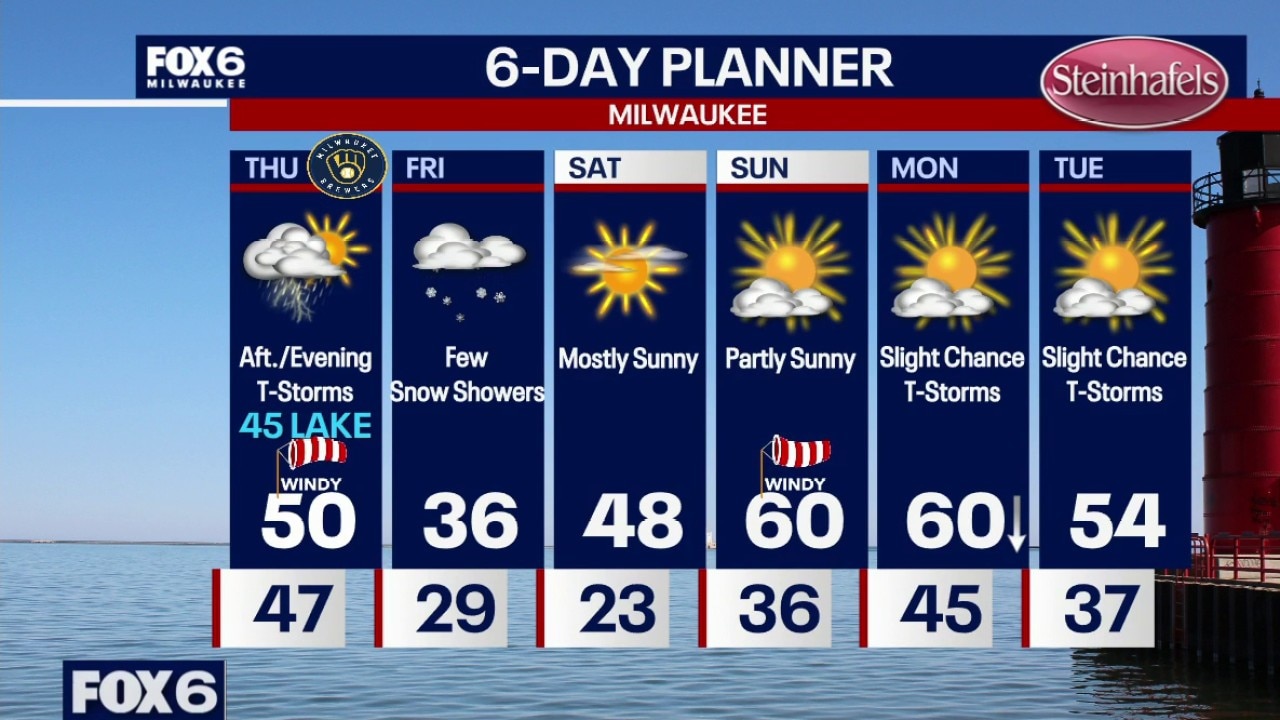
Breaking. MUCH cooler for Opening Day. Faster cold front means temperatures in the 40s for tailgating. Mostly clear tonight with temperatures in the 50s this evening and 40s overnight. The cold front is moving faster which means a NE wind on Thursday.
Breaking. MUCH cooler for Opening Day. Faster cold front means temperatures in the 40s for tailgating. Mostly clear tonight with temperatures in the 50s this evening and 40s overnight. The cold front is moving faster which means a NE wind on Thursday.
Weather Webcast with Chief Meteorologist Tom Wachs
Breaking. MUCH cooler for Opening Day. Faster cold front means temperatures in the 40s for tailgating.
Breaking. MUCH cooler for Opening Day. Faster cold front means temperatures in the 40s for tailgating.
Weather Webcast with Stephanie Barichello
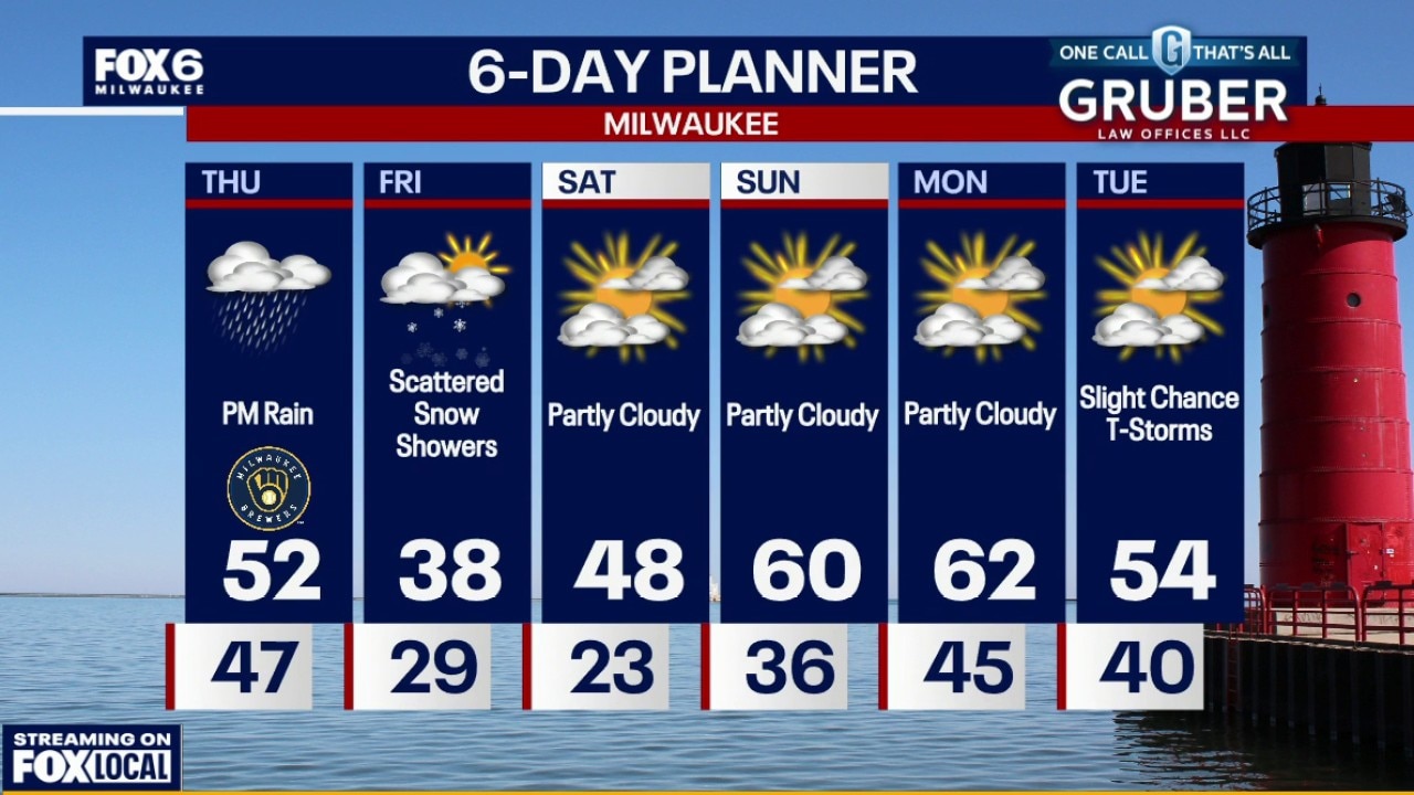
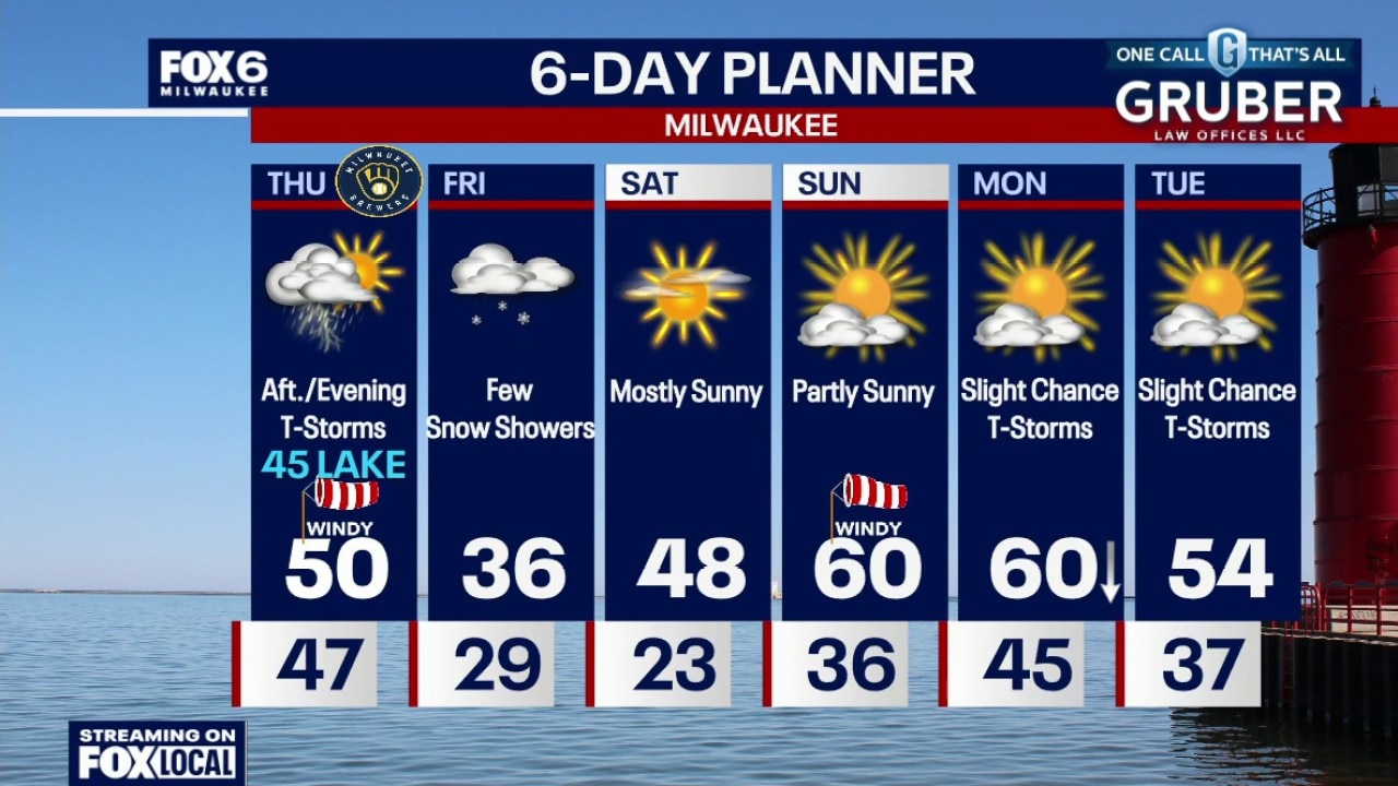
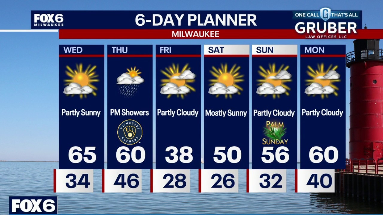
Cooler on Thursday for opening day thanks to a quicker cold front and lake breeze. Rain showers are likely during the afternoon and evening, with the possibility of severe weather south of us in IL. Chilly with flurries on Friday then warming over the weekend.
Cooler on Thursday for opening day thanks to a quicker cold front and lake breeze. Rain showers are likely during the afternoon and evening, with the possibility of severe weather south of us in IL. Chilly with flurries on Friday then warming over the weekend.
Weather webcast with Stephanie Barichello
Another classic Wisconsin spring fake-out as we spike into the 60s Wednesday with a legit taste of spring before a cold front cuts through Thursday and sends temps falling through the afternoon.
Another classic Wisconsin spring fake-out as we spike into the 60s Wednesday with a legit taste of spring before a cold front cuts through Thursday and sends temps falling through the afternoon.
Weather webcast with Rob Haswell
Another classic Wisconsin spring fake-out as we spike into the 60s Wednesday with a legit taste of spring before a cold front cuts through Thursday and sends temps falling through the afternoon.
Another classic Wisconsin spring fake-out as we spike into the 60s Wednesday with a legit taste of spring before a cold front cuts through Thursday and sends temps falling through the afternoon.
Weather Webcast with Chief Meteorologist Tom Wachs
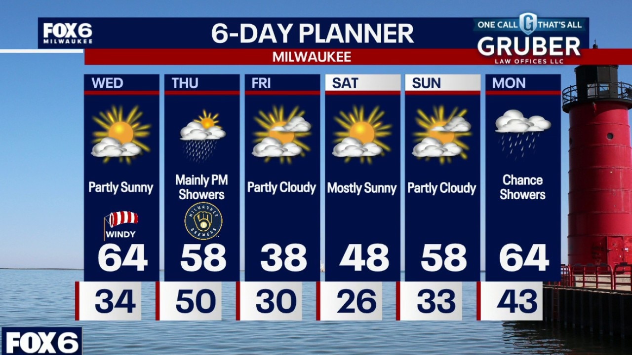
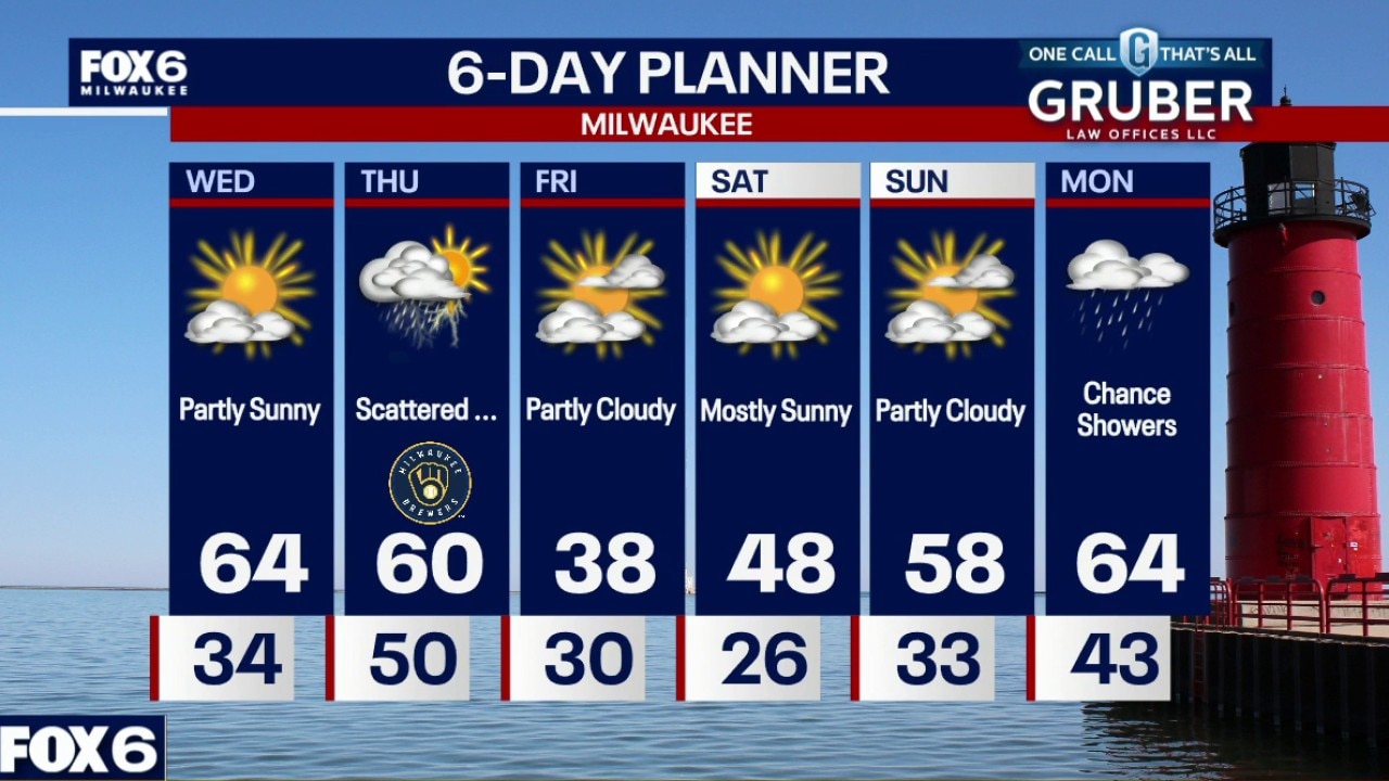
Partly to mostly cloudy. Temperatures dropping into the 30s overnight. Mostly cloudy, breezy and warmer on Wednesday. Highs in the mid-60s.
Partly to mostly cloudy. Temperatures dropping into the 30s overnight. Mostly cloudy, breezy and warmer on Wednesday. Highs in the mid-60s.

Weather Webcast with Chief Meteorologist Tom Wachs
Partly to mostly cloudy. Temperatures dropping into the 30s tonight. Mostly cloudy, breezy and warmer on Wednesday. Highs in the mid-60s.
Partly to mostly cloudy. Temperatures dropping into the 30s tonight. Mostly cloudy, breezy and warmer on Wednesday. Highs in the mid-60s.
Weather Webcast with Stephanie Barichello
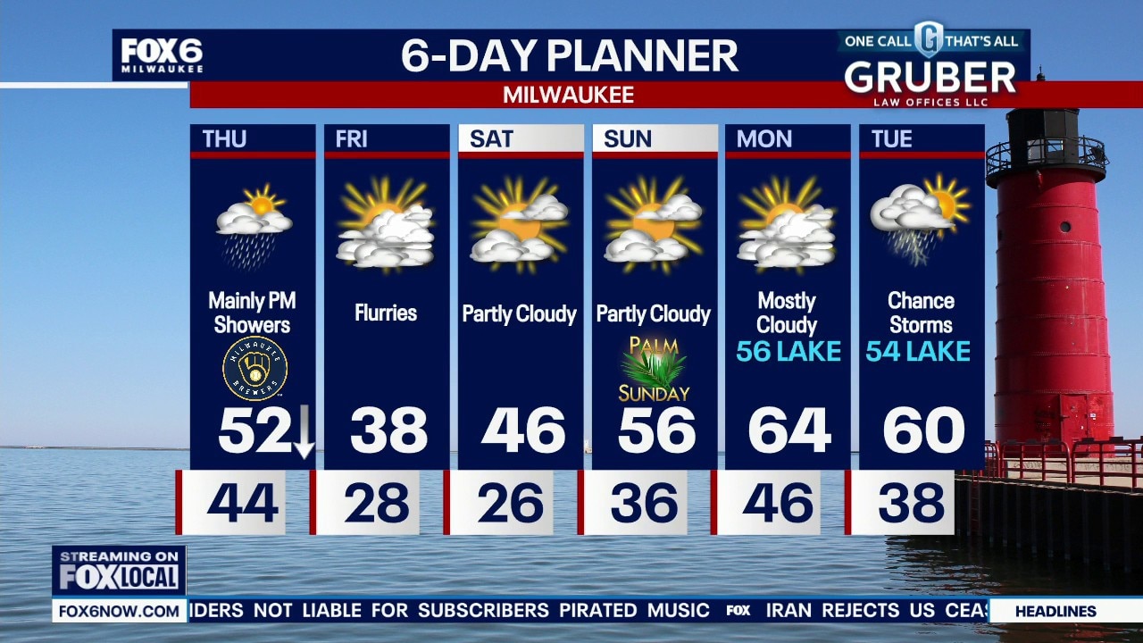
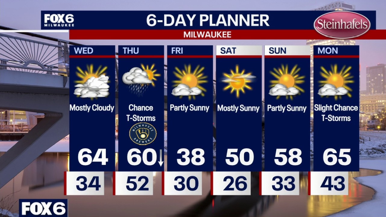
A beautiful Wednesday in store with some sunshine and temperatures in the middle 60s. There is a chance for rain on Thursday, mainly during the afternoon and evening, so tailgating for the Brewers Home Opener looks dry and mild. Cold Friday behind that system then warming over the weekend.
A beautiful Wednesday in store with some sunshine and temperatures in the middle 60s. There is a chance for rain on Thursday, mainly during the afternoon and evening, so tailgating for the Brewers Home Opener looks dry and mild. Cold Friday behind that system then warming over the weekend.
Weather webcast with Stephanie Barichello
Alright, this is one of those classic spring fake-outs where we warm things up nicely midweek before reminding you it’s still March.
Alright, this is one of those classic spring fake-outs where we warm things up nicely midweek before reminding you it’s still March.

Weather webcast with Rob Haswell
Alright, this is one of those classic spring fake-outs where we warm things up nicely midweek before reminding you it’s still March.
Alright, this is one of those classic spring fake-outs where we warm things up nicely midweek before reminding you it’s still March.
Weather Webcast with Chief Meteorologist Tom Wachs
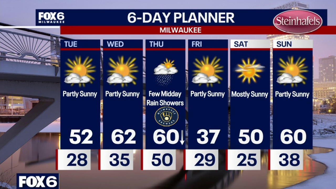
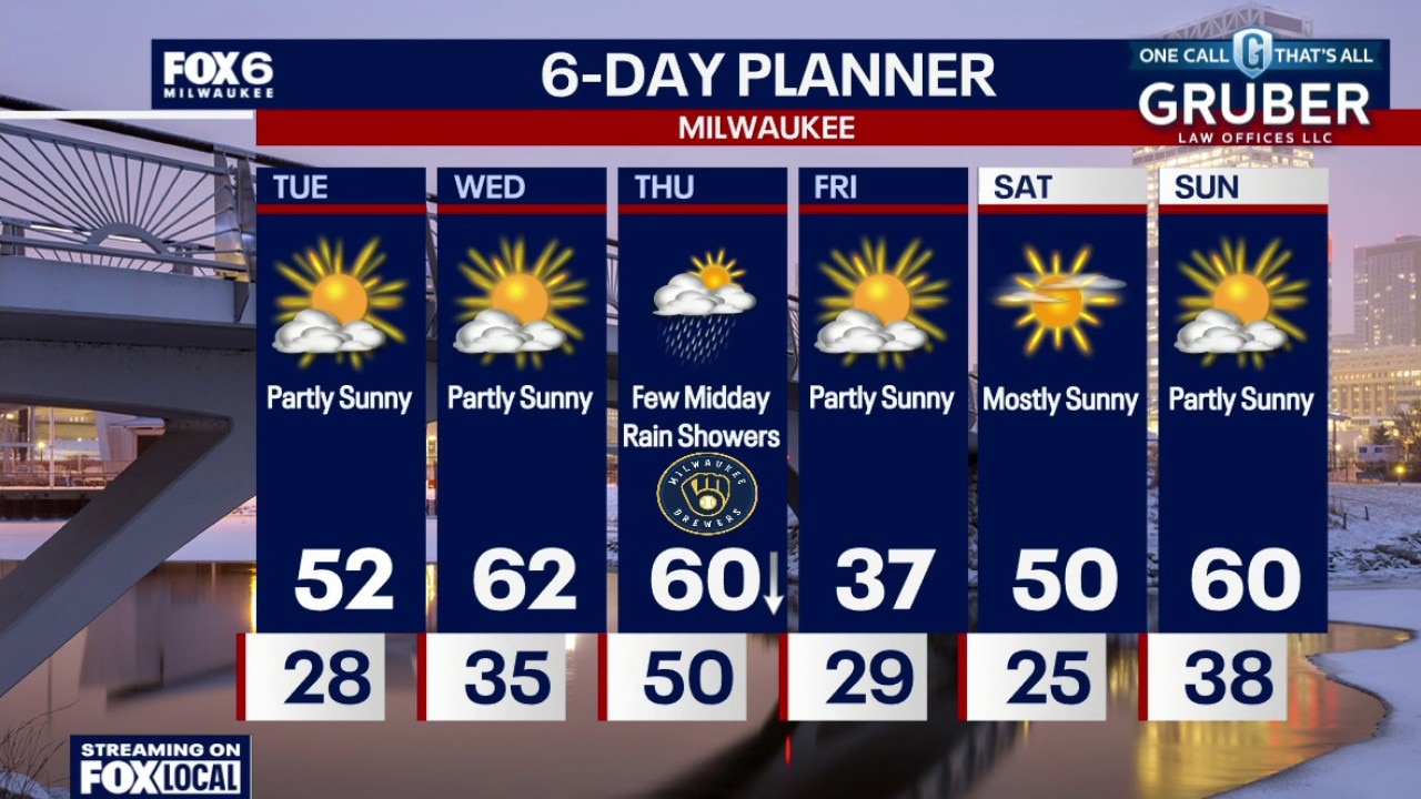
Partly cloudy overnight with lows in the upper 20s by sunrise. Partly sunny and warmer on Tuesday with highs in the low 50s. Warm and breezy on Wednesday with highs in the low 60s.
Partly cloudy overnight with lows in the upper 20s by sunrise. Partly sunny and warmer on Tuesday with highs in the low 50s. Warm and breezy on Wednesday with highs in the low 60s.
Weather Webcast with Chief Meteorologist Tom Wachs
Mostly clear tonight with temperatures dropping through the 30s. Partly cloudy overnight with lows in the upper 20s by sunrise. Partly sunny and warmer on Tuesday with highs in the low 50s. Warm and breezy on Wednesday with highs in the low 60s.
Mostly clear tonight with temperatures dropping through the 30s. Partly cloudy overnight with lows in the upper 20s by sunrise. Partly sunny and warmer on Tuesday with highs in the low 50s. Warm and breezy on Wednesday with highs in the low 60s.