

Hurricane Laura: Wind, rain pummel coasts of Louisiana, Texas as ferocious storm makes landfall
LOS ANGELES - Hurricane Laura roared ashore in southwestern Louisiana near the Texas border as a menacing Category 4 hurricane late Wednesday, pushing ocean water topped with waves onto low-lying land.
Laura made landfall near Lake Charles, Louisiana with winds of 150 mph with a minimum central pressure of 938 mb.
Winds gusted above hurricane force to 127 mph while Laura's northern eyewall moved onshore over Cameron Parish, the National Hurricane Center said, and forecasters said even stronger winds were possible that could rip apart buildings, level trees and toss vehicles like toys.
Tens of thousands were without power as howling winds and sheets of rain from the hurricane pummeled the Louisiana and Texas coasts.
As of early Thursday morning, nearly 200,000 customers in Louisiana and over 52,000 in Texas were without power according to poweroutage.us.
Wednesday afternoon, freelance photographer Kevin Snyder captured more than a dozen electrical trucks heading south near Centerville, Texas to help assist in cleanup and restore widespread power outages safely and quickly.
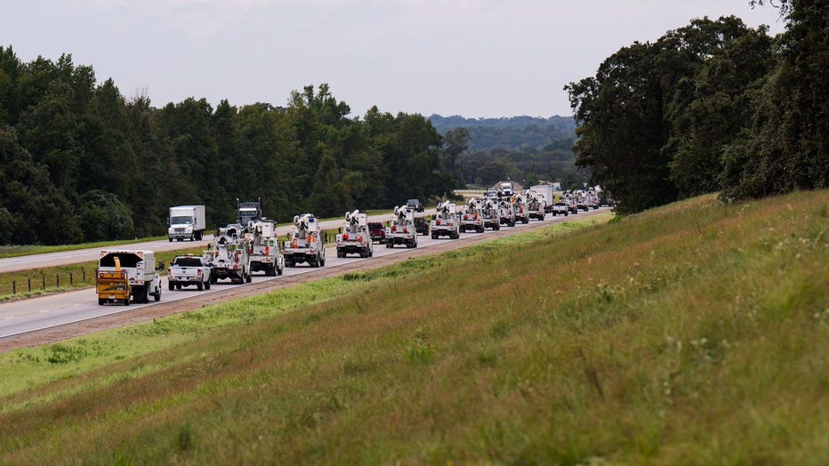
Electrical trucks head south to help out during Hurricane Laura (Kevin Snyder)
As of 3 a.m. CDT, the National Hurricane Center (NHC) reported that Laura was pushing northward over Southwestern Louisiana. "Catastrophic storm surge, extreme winds and flash flooding continues in portions of Louisiana," NHC wrote.
Laura, a potentially life-threatening hurricane, has raised fears of a 20-foot storm surge that forecasters said would be “unsurvivable” and capable of inundating entire communities.
Video and photos on social media showed torrents of rain flying sideways past street lights in Lake Charles, and streets covered with water closer to the coast. A sudden storm surge knocked over cameras meant to capture the hurricane’s effects.

With hours of violent weather ahead, officials said the extent of destruction likely wouldn't be clear until daybreak, when search and rescue missions will begin.
The storm grew nearly 87% in power in just 24 hours to a size the National Hurricane Center called “extremely dangerous.”
“It looks like it’s in full beast mode, which is not what you want to see if you’re in its way," University of Miami hurricane researcher Brian McNoldy said.
As of Wednesday night, Hurricane Laura was a Category 4, packing winds at 150 mph, which is just short of Category 5 strength (157+ mph).
Meteorologists across the country had said there were increasing signs that Hurricane Laura could reach Category 5 strength before making landfall, but it maintained its Category 4 status as it slammed into the Louisiana coast.
Hurricane-force winds extended 60 miles from the storm’s center, forecasters said, and bands of heavy rain fell 30 miles from the beach in Lake Charles.
RELATED: Buses with Hurricane Laura evacuees begin arriving in North Texas
What are the threats from Laura?
The main threats from Laura include heavy rain, dangerous storm surge, flooding, gusty winds and short-lived tornadoes.
A catastrophic storm surge will impact the region and a threat of flooding rain will extend well inland.
Cline said 15 to 20 feet of storm surge will be possible with Hurricane Laura.
“Those numbers are kind of surreal, ” Cline said. “So, if you lived in a two-story house, the water would be up to the roof.” Cline said a two-story house would not hold up in the expected conditions.
According to the National Hurricane Center, storm surge could move 40 miles inland from the coast in southwest Louisiana and southeast Texas.
RELATED: Houston-area closures and cancellations due to Hurricane Laura
Tropical storm wind conditions have already begun in hurricane warning areas, and hurricane force winds are expected Wednesday evening into Thursday.
Gusts could cause widespread power outages and uprooted trees, and Category 4 conditions have the potential to leave widespread power outages for months.
The National Weather Service issued an Extreme Wind Warning prior to the landfall of Hurricane Laura. "Winds will increase rapidly soon as the northern eyewall moves onshore," NWS wrote.
Rainfall amounts between 6-10 inches will be possible with the system, with potential localized rainfall totals around 10-15 inches.
Showers are likely to persist through the weekend, as the system weakens and moves across the United States.
Laura is expected to dump massive rainfall as it moves inland, causing widespread flash flooding in states far from the coast.
Flood watches were issued for much of Arkansas, and forecasters said heavy rainfall could arrive by Friday in parts of Missouri, Tennessee and Kentucky.
Laura is so powerful that it's expected to become a tropical storm again once it reaches the Atlantic Ocean, potentially menacing the Northeast.
Where is Laura headed?
Drawing energy from the warm Gulf of Mexico waters, the system was on track to arrive near midnight CDT— late Wednesday or early Thursday — as the most powerful hurricane to strike the U.S. so far this year.
Early Wednesday, outer rain bands from Laura and wind gusts were already sweeping into sections of Louisiana as the storm continued to churn inland from the gulf. One major Louisiana highway already had standing water as Laura's outer bands moved ashore.
By midnight local time, the Laura's gale-force winds were lashing the Lousiana coast and triggering tornado warnings.
As of early Thursday morning CT, Laura made landfall and was moving north at 15 mph.
Models predict this system will continue its trajectory northward through Thursday before curling to the east and moving toward the East Coast.
Laura is expected to spread rain and wind inland through Arkansas and then through parts of the lower Mississippi Valley and Ohio Valley into Saturday.
Hurricane Laura is projected to finally move toward the East coast near northern Virgina and Washington D.C. before heading back out into the Atlantic Ocean.
Evacuations are currently in place
With time running out, both Texas Gov. Greg Abbott and Louisiana Gov. John Bel Edwards expressed concerns that not enough coastal residents were taking the dire predictions seriously.
In Lake Charles, National Guard members drove school buses around neighborhoods, offering to pick up families.
The Vermilion Parish Policy Jury issued a mandatory evacuation on Wednesday for some areas in Vermilion Parish, Louisiana.
The Vermilion Parish Sheriff’s Office issued a grim warning to residents choosing to ride out Hurricane Laura rather than evacuate.
“Please evacuate and if you choose to stay and we can’t get to you, write your name, address, social security number and next of kin and put it a ziplock bag in your pocket. Praying that it does not come to this,” the post stated. “Expecting the worse buy praying for the best.”
Hurricane warnings were in effect for Luis Pass, Texas, to Intracoastal City, Louisiana. Areas under warnings included Galveston, parts of Houston, Beaumont and Port Arthur, Texas, and Lake Charles, Louisiana.
Tropical storm warnings also extended into sections of Houston, parts of northern Texas, northern Louisiana and southern Arkansas.
A storm surge warning was in effect from Freeport, Texas to the Mississippi River in southeast Louisiana.
NOAA's Storm Prediction Center has issued a tornado watch until 8 a.m. CT Thursday for parts of Louisiana and southeastern Texas.
Authorities implored coastal residents of Texas and Louisiana to evacuate.
The National Weather Service building in Lake Charles, Louisiana was evacuated early Wednesday.
RELATED: LIST: Evacuations ordered in these SE Texas counties and cities
“Heed the advice of your local authorities. If they tell you to go, go! Your life depends on it today,” said Cline. “It’s a serious day and you need to listen to them.”
On Twitter, President Donald Trump also urged coastal residents to heed local officials.
In the largest U.S. evacuation during this pandemic era, more than half a million people were ordered to flee from their homes near the Texas-Louisiana state line, including the Texas cities of Beaumont, Galveston and Port Arthur, and the low-lying Calcasieu and Cameron parishes in southwestern Louisiana, where forecasters said storm surge topped by waves could submerge entire towns.
The Associated Press contributed to this story.