

Weather Webcast with Lisa Michaels
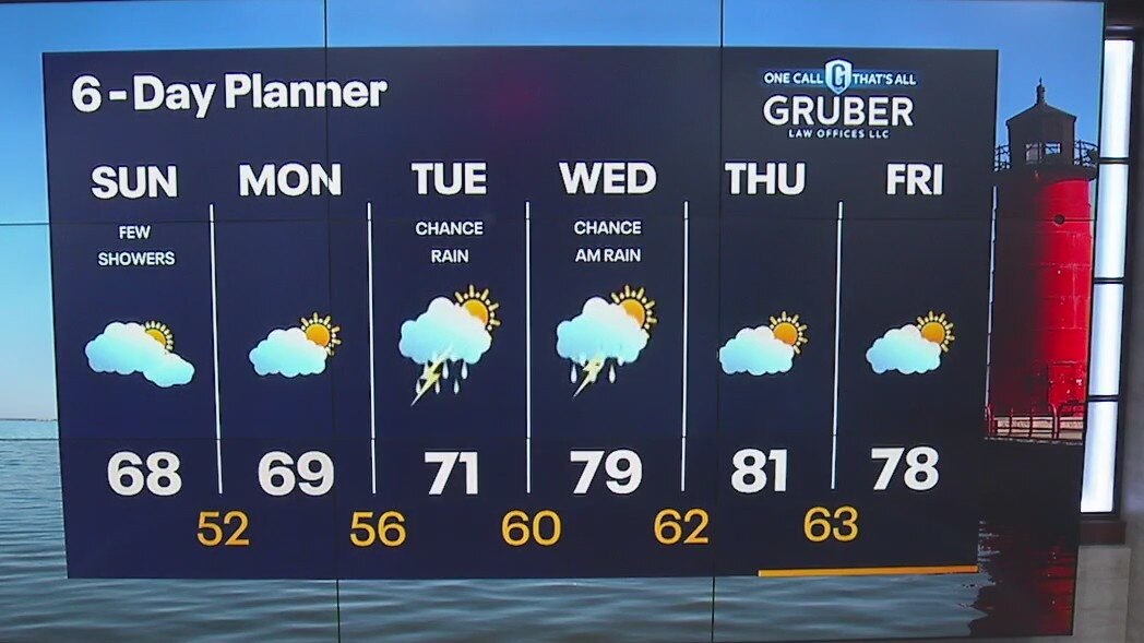
Light rain and drizzle continues early Sunday. Potential waterspouts over Lake Michigan today. Slightly cooler Sunday with highs in the mid to upper 60s. High pressure moves in clearing rain and clouds out this afternoon.
Light rain and drizzle continues early Sunday. Potential waterspouts over Lake Michigan today. Slightly cooler Sunday with highs in the mid to upper 60s. High pressure moves in clearing rain and clouds out this afternoon.

Weather Webcast with Stephanie Barichello
A few lingering showers Sunday morning then drying out and staying cooler. Beautiful Monday then a chance for rain Tuesday into Wednesday.
A few lingering showers Sunday morning then drying out and staying cooler. Beautiful Monday then a chance for rain Tuesday into Wednesday.

Tropical Depression Fifteen in Atlantic likely to become Tropical Storm Nigel soon
Invest 97L strengthened into Tropical Depression Fifteen in the Atlantic on Friday and is well on its way to eventually becoming Tropical Storm Nigel.
Invest 97L strengthened into Tropical Depression Fifteen in the Atlantic on Friday and is well on its way to eventually becoming Tropical Storm Nigel.

Second US death reported as Lee skirts New England with high winds, dangerous waves
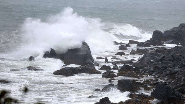
A second death related to Lee was reported Saturday when winds from the sprawling storm blew down a tree onto a Maine man's car.
A second death related to Lee was reported Saturday when winds from the sprawling storm blew down a tree onto a Maine man's car.
Weather Webcast with Stephanie Barichello
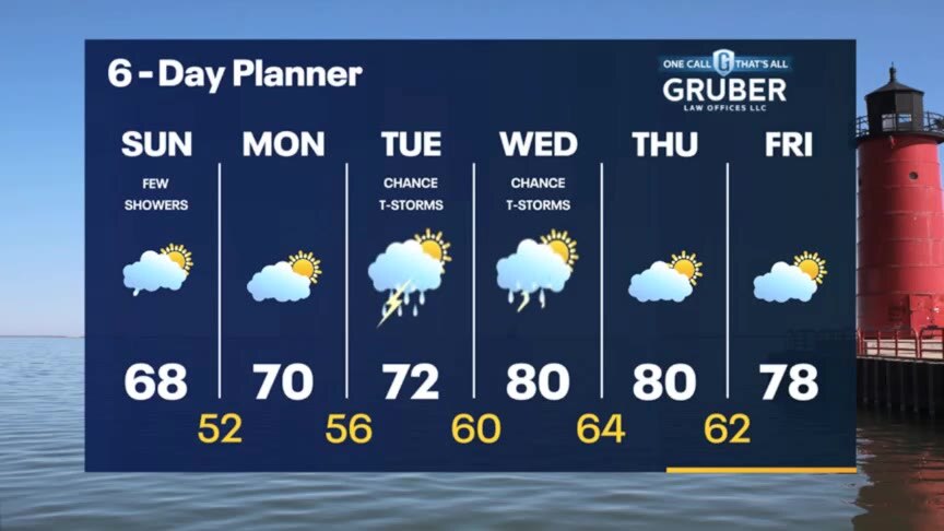
Scattered thunderstorms tonight then a few lingering showers Sunday morning. Drying out Sunday afternoon and Monday then rain returns Tuesday. 80s are back by midweek.
Scattered thunderstorms tonight then a few lingering showers Sunday morning. Drying out Sunday afternoon and Monday then rain returns Tuesday. 80s are back by midweek.
Weather Webcast with Meteorologist Lisa Michaels
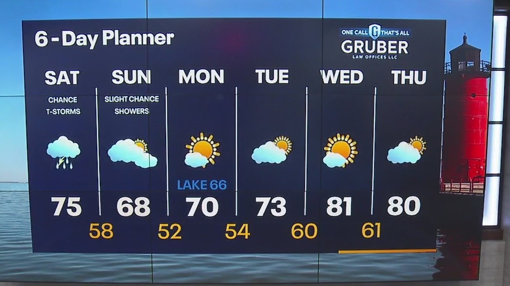
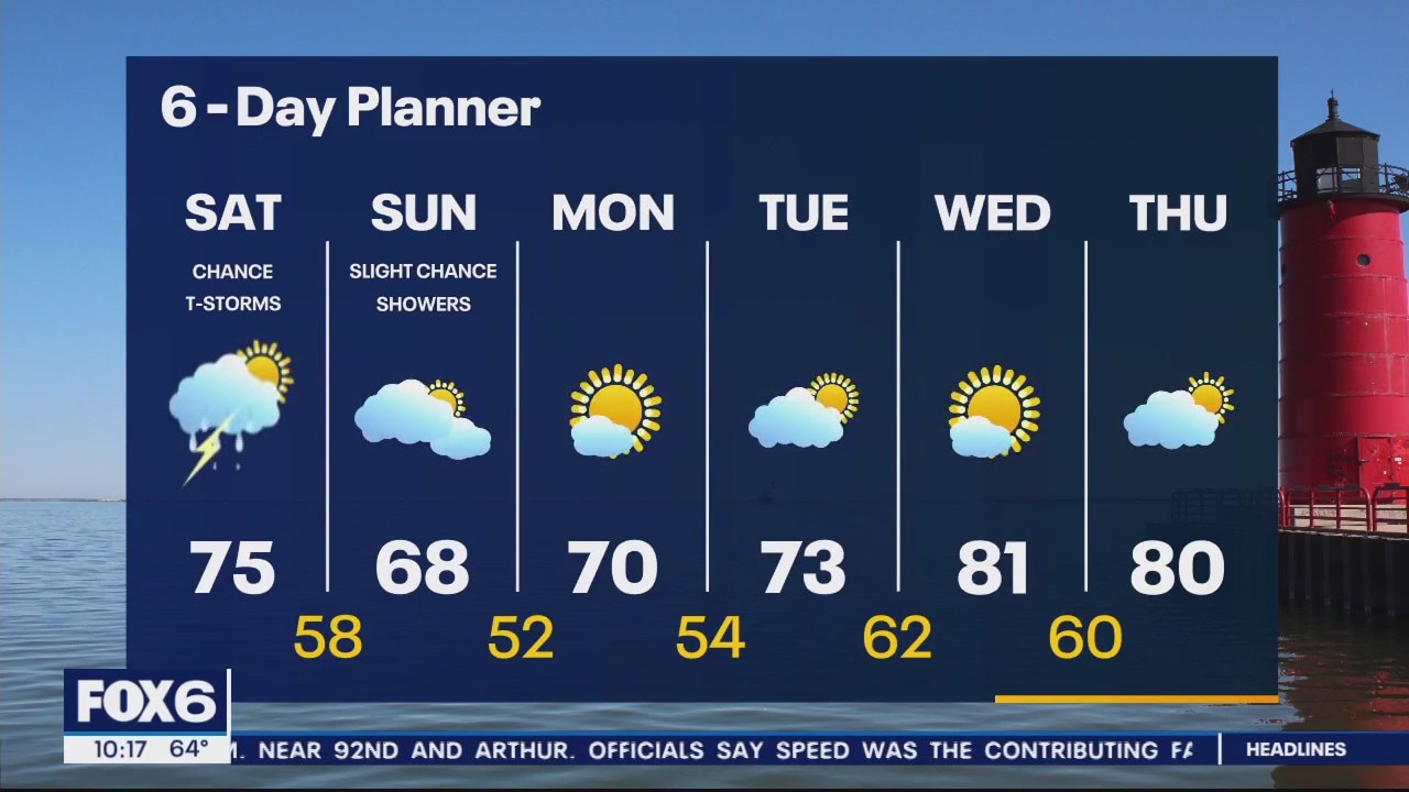
Clouds sticking around Saturday with mild temps in the mid to upper 70s. Scattered rain and storms during Saturday afternoon into the evening hours. A few showers could linger into early Sunday. Otherwise cooler on Sunday in the upper 60s.
Clouds sticking around Saturday with mild temps in the mid to upper 70s. Scattered rain and storms during Saturday afternoon into the evening hours. A few showers could linger into early Sunday. Otherwise cooler on Sunday in the upper 60s.
Weather Webcast with Meteorologist Eric Manges
Chance of rain Saturday into Sunday morning then warming temperatures long term
Chance of rain Saturday into Sunday morning then warming temperatures long term

Sprawling Hurricane Lee's impacts begin as winds, power outages increase in New England
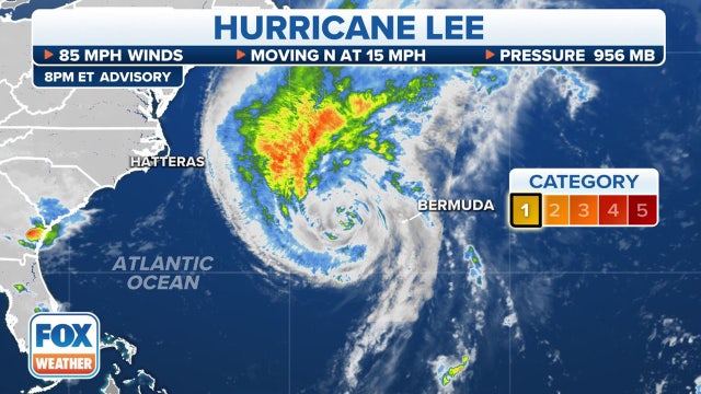
While the center of the storm will likely stay east of the U.S. and move into the Canadian Maritimes, Lee's massive wind field is hundreds of miles across and will not spare the New England coast from its wrath.
While the center of the storm will likely stay east of the U.S. and move into the Canadian Maritimes, Lee's massive wind field is hundreds of miles across and will not spare the New England coast from its wrath.
Weather Webcast with Meteorologist Eric Manges
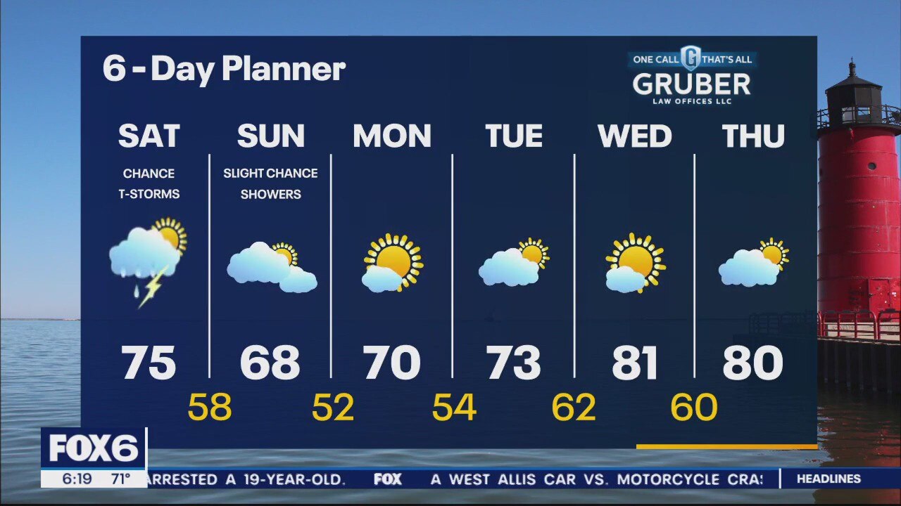
Scattered shower chances through out Saturday into Sunday early morning then warmer to end next week
Scattered shower chances through out Saturday into Sunday early morning then warmer to end next week

Weather Webcast with Stephanie Barichello
Sunny and warmer today then a chance for showers and storms Saturday afternoon and evening. A few showers may linger Sunday then drying out. Warming up again by midweek.
Sunny and warmer today then a chance for showers and storms Saturday afternoon and evening. A few showers may linger Sunday then drying out. Warming up again by midweek.
Weather webcast with Rob Haswell
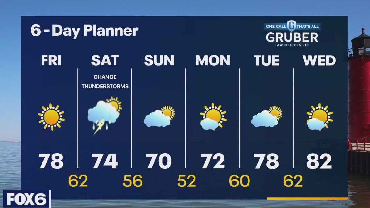
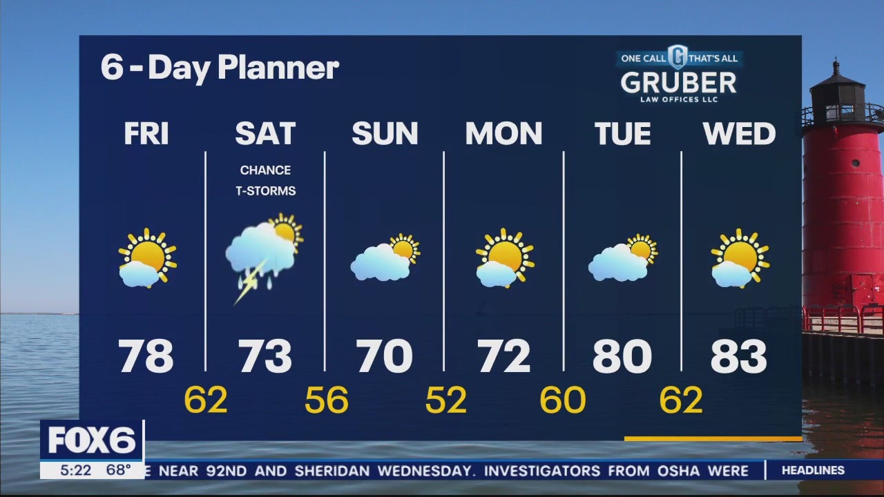
With ample sun ahead of a pair weak cold fronts today, we warm up very efficiently. Highs will reach the upper 70s in most areas. The first of two fronts will bring a chance for showers overnight into early Saturday morning while the trailing front brings a round of showers and thunderstorms later Saturday afternoon and evening. Highs will fall to the low 70s Sunday and Monday, but we warm up again later next week with highs returning to the 80s by Wednesday. The extended range temperature trends look to be on the warm side through the end of the month.
With ample sun ahead of a pair weak cold fronts today, we warm up very efficiently. Highs will reach the upper 70s in most areas. The first of two fronts will bring a chance for showers overnight into early Saturday morning while the trailing front brings a round of showers and thunderstorms later Saturday afternoon and evening. Highs will fall to the low 70s Sunday and Monday, but we warm up again later next week with highs returning to the 80s by Wednesday. The extended range temperature trends look to be on the warm side through the end of the month.
Tropical Storm Warnings expanded across New England as Hurricane Lee makes final approach
Boston could see sustained tropical-storm-force-winds by Friday evening through the first part of the weekend, and concerns are growing that with leaves still on trees the expected wind and possible heavy rain could snap branches and limbs and pull down power lines, leaving thousands of people in the dark.
Boston could see sustained tropical-storm-force-winds by Friday evening through the first part of the weekend, and concerns are growing that with leaves still on trees the expected wind and possible heavy rain could snap branches and limbs and pull down power lines, leaving thousands of people in the dark.
Weather Webcast with Meteorologist Eric Manges
Nice end to the week then rain potential on Saturday
Nice end to the week then rain potential on Saturday

What was the last hurricane to make landfall in Maine?
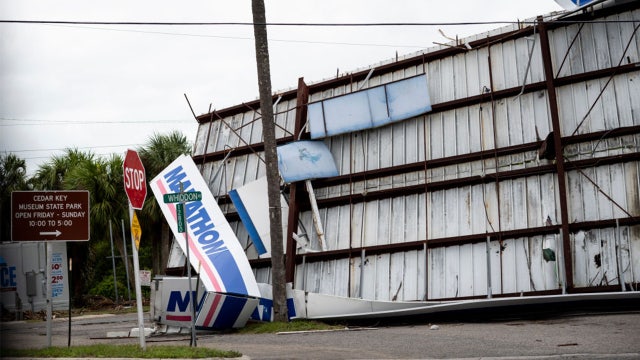
Maine does have a history of landfalling hurricanes, but they don't happen often. Hurricane Lee could become the newest addition to that history as it eyes the state's coastline later this week.
Maine does have a history of landfalling hurricanes, but they don't happen often. Hurricane Lee could become the newest addition to that history as it eyes the state's coastline later this week.
Weather Webcast with Stephanie Barichello
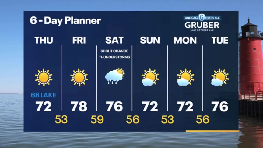
Mostly sunny and pleasant today with temperatures in the 60s and 70s. Warmer and breezy Friday in the upper 70s. A few sprinkles possible late Friday night, better chance for rain and some thunder Saturday afternoon and evening. Quiet, cooler by Sunday.
Mostly sunny and pleasant today with temperatures in the 60s and 70s. Warmer and breezy Friday in the upper 70s. A few sprinkles possible late Friday night, better chance for rain and some thunder Saturday afternoon and evening. Quiet, cooler by Sunday.

Weather webcast with Rob Haswell
High pressure moving to our east keeps us on the sunny side and helps us warm into the low 70s. It will be cooler near the lake as the wind sifts in off the water. We keep warming with ample sun and a southwest wind Friday. Highs should reach the mid to upper 70s. A system arrives Saturday with a chance for showers and a slight chance for thunderstorms. We will cool slightly behind that low. We warm up again by the middle of next week.
High pressure moving to our east keeps us on the sunny side and helps us warm into the low 70s. It will be cooler near the lake as the wind sifts in off the water. We keep warming with ample sun and a southwest wind Friday. Highs should reach the mid to upper 70s. A system arrives Saturday with a chance for showers and a slight chance for thunderstorms. We will cool slightly behind that low. We warm up again by the middle of next week.
Weather Webcast with Lisa Michaels
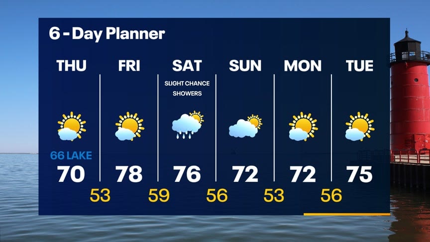
Mostly clear tonight with temps dripping into the low to mid 40s by Thursday morning. Areas of moderate to dense fog are possible during the start of Thursday. Mostly sunny skies Thursday with highs in the upper 60s to 70 degrees. Warmer temperatures return by Friday in the upper 70s. Next chance of rain arrives by Saturday. Tonight: Mostly Clear
Mostly clear tonight with temps dripping into the low to mid 40s by Thursday morning. Areas of moderate to dense fog are possible during the start of Thursday. Mostly sunny skies Thursday with highs in the upper 60s to 70 degrees. Warmer temperatures return by Friday in the upper 70s. Next chance of rain arrives by Saturday. Tonight: Mostly Clear
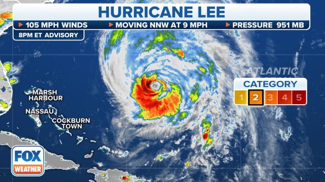

New England on alert: Hurricane and Tropical Storm watches issued for much of coastline ahead of Lee's arrival
The National Hurricane Center in coordination for local National Weather Services offices issued a Hurricane Watch from Stonington, Maine to the U.S.- Canada border and a Tropical Storm Watch is in effect for from Watch Hill, Rhode Island to Stonington, Maine.
The National Hurricane Center in coordination for local National Weather Services offices issued a Hurricane Watch from Stonington, Maine to the U.S.- Canada border and a Tropical Storm Watch is in effect for from Watch Hill, Rhode Island to Stonington, Maine.


Lake Michigan waterspouts, people along shore capture sight
Waterspouts out over Lake Michigan were spotted Wednesday morning, Sept. 13.
Waterspouts out over Lake Michigan were spotted Wednesday morning, Sept. 13.
Weather Webcast with Stephanie Barichello
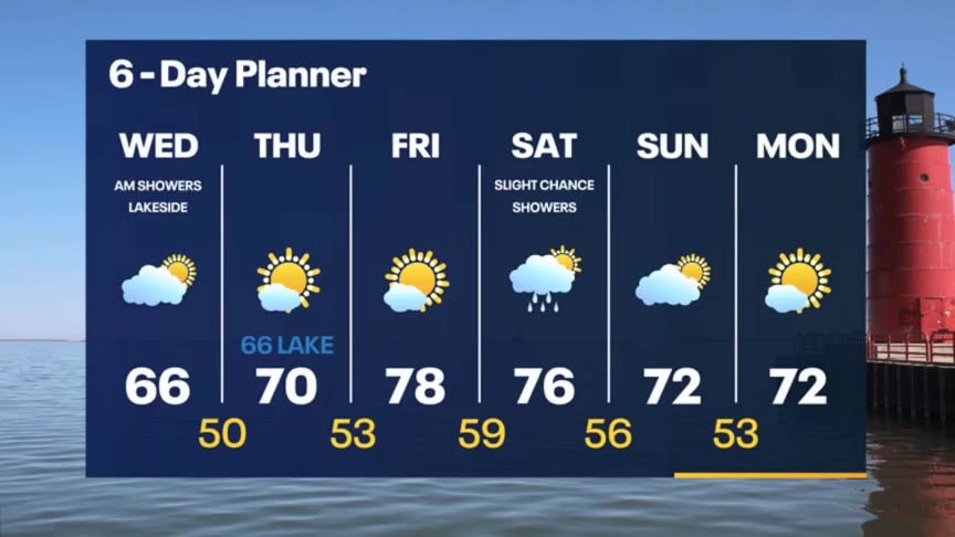
After an eventful morning of waterspout sightings, we enjoy sunshine the rest of the afternoon. Temperatures will be cool in the 60s. Even colder tomorrow morning with lows in the 40s, possibly even 30s, then we jump into the upper 70s by Friday.
After an eventful morning of waterspout sightings, we enjoy sunshine the rest of the afternoon. Temperatures will be cool in the 60s. Even colder tomorrow morning with lows in the 40s, possibly even 30s, then we jump into the upper 70s by Friday.