


Linus helps Rob with the weather
Meet 10-year-old Linus -- our latest Future Forecaster.
Meet 10-year-old Linus -- our latest Future Forecaster.

Meet 10-year-old Linus
He wanted to be a Future Forecaster -- and that's exactly what FOX6 WakeUp News is helping him?accomplish.
He wanted to be a Future Forecaster -- and that's exactly what FOX6 WakeUp News is helping him?accomplish.
Weather webcast with Rob Haswell
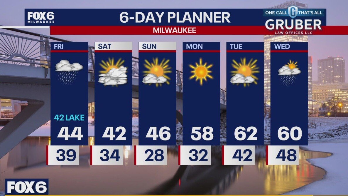
A low moves from Missouri to Michigan over the next 24 hours bringing us rain today and tonight. Some areas could see up to .75" or more. Temperatures will be steady in the low 40s during the day but fall to the 30s behind the cold front later tonight. A cooler Saturday with a chance for very isolated snow showers but then we warm up. We should be back in the 50s and low 60s Monday through Wednesday. After Saturday we dry up for several days.
A low moves from Missouri to Michigan over the next 24 hours bringing us rain today and tonight. Some areas could see up to .75" or more. Temperatures will be steady in the low 40s during the day but fall to the 30s behind the cold front later tonight. A cooler Saturday with a chance for very isolated snow showers but then we warm up. We should be back in the 50s and low 60s Monday through Wednesday. After Saturday we dry up for several days.
Weather webcast with Rob Haswell
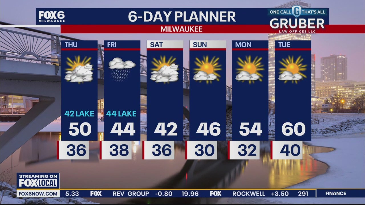
Mostly cloudy but also mostly dry today with any precip waiting until overnight into Friday to arrive in our area. Highs today will be in the upper 40s to near 50 away from the lake with low 40s lakeside due to a steady SE wind. Light rain through the day on Friday will keep temperatures in the low 40s across the area and as the cold front clears we cool to the upper 30s and low 40s Saturday. We should clear by Saturday afternoon and start warming again Sunday with highs returning to the 50s and near 60 by the middle of next week.
Mostly cloudy but also mostly dry today with any precip waiting until overnight into Friday to arrive in our area. Highs today will be in the upper 40s to near 50 away from the lake with low 40s lakeside due to a steady SE wind. Light rain through the day on Friday will keep temperatures in the low 40s across the area and as the cold front clears we cool to the upper 30s and low 40s Saturday. We should clear by Saturday afternoon and start warming again Sunday with highs returning to the 50s and near 60 by the middle of next week.

Where, how often does lightning strike in US? New report explains
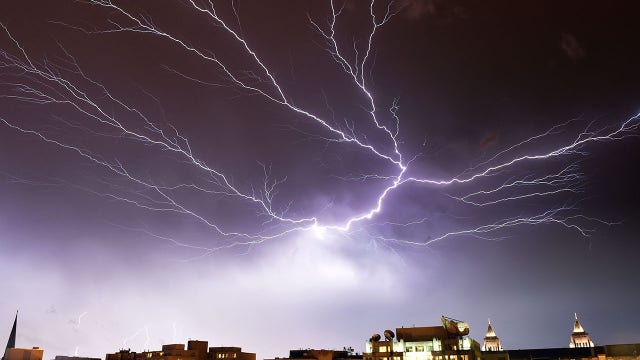
A research team used six years of data from the National Lightning Detection Network to study where and how often lightning strikes occur in the U.S.
A research team used six years of data from the National Lightning Detection Network to study where and how often lightning strikes occur in the U.S.
Weather webcast with Lisa Michaels
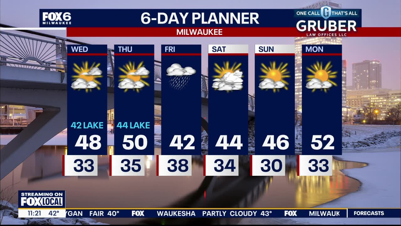
Once again we will be cooler near the lake with a steady NE breeze. We stay dry today and through the day Thursday but rain returns for Friday. There is a possibility of a brief period of wintry mix or snow overnight Friday into early Saturday before we clear out again.
Once again we will be cooler near the lake with a steady NE breeze. We stay dry today and through the day Thursday but rain returns for Friday. There is a possibility of a brief period of wintry mix or snow overnight Friday into early Saturday before we clear out again.
Weather webcast with Rob Haswell
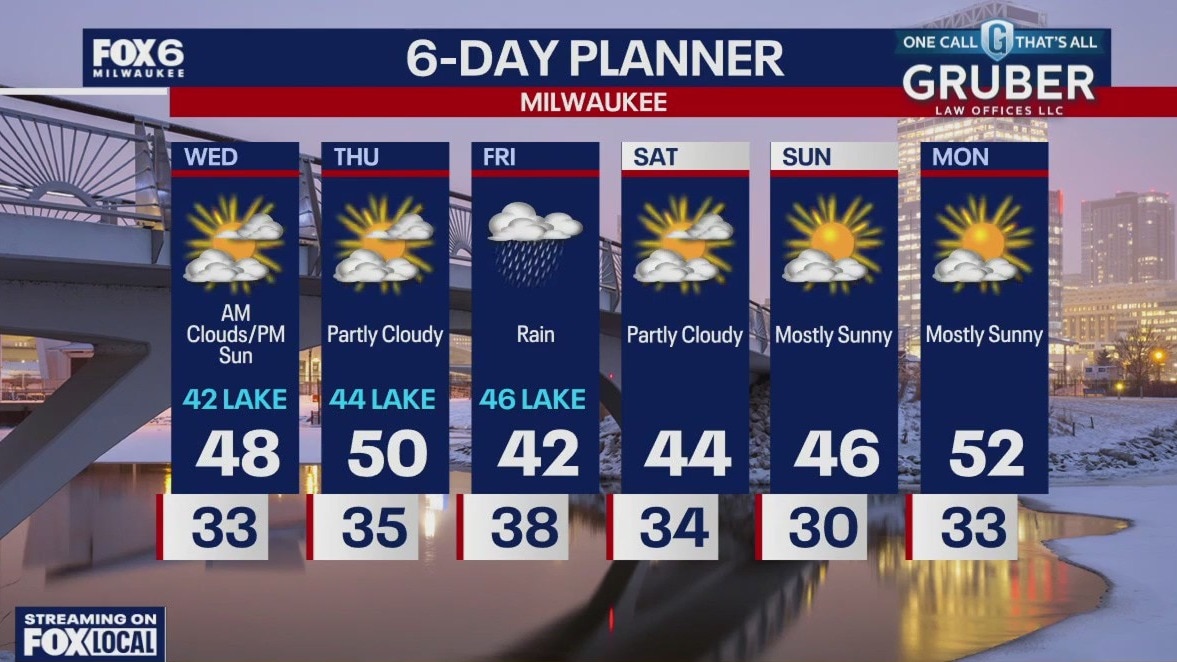
Quiet the next couple of days with some sunshine and a range of 40s, coolest lakeside. Rain showers are likely Friday. It will be a windy and raw day with temperatures in the low 40s.
Quiet the next couple of days with some sunshine and a range of 40s, coolest lakeside. Rain showers are likely Friday. It will be a windy and raw day with temperatures in the low 40s.


Wild Wisconsin winter; El Niño's impact on the weather
Winter in Wisconsin has been wild, filled with unusual weather patterns.
Winter in Wisconsin has been wild, filled with unusual weather patterns.
Weather webcast with Lisa Michaels
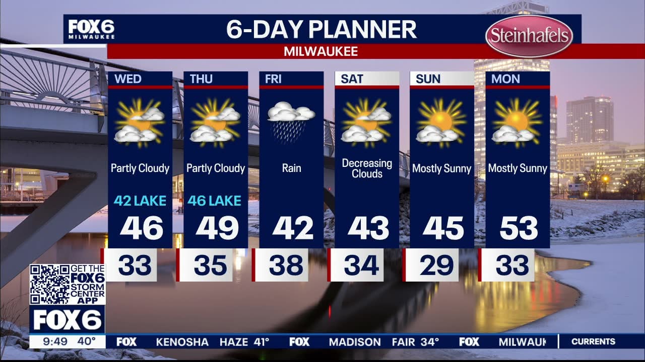
Partly cloudy tonight with temperatures falling into the low 30s. Quiet the next couple of days with some sunshine and a range of 40s, coolest lakeside. Rain showers are likely Friday. It will be a windy and raw day with temperatures in the low 40s. Rain possible early Saturday, but drying out over the weekend and gradually warming to around 50 by Monday.
Partly cloudy tonight with temperatures falling into the low 30s. Quiet the next couple of days with some sunshine and a range of 40s, coolest lakeside. Rain showers are likely Friday. It will be a windy and raw day with temperatures in the low 40s. Rain possible early Saturday, but drying out over the weekend and gradually warming to around 50 by Monday.
Weather webcast with Rob Haswell
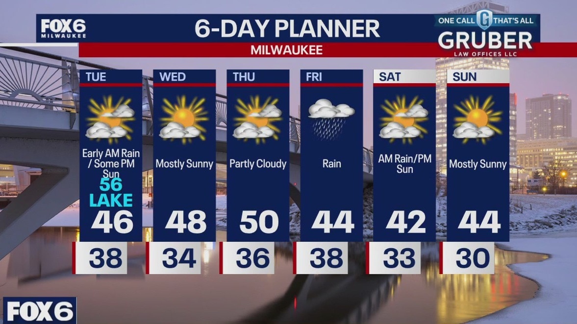
Light rain winds down early this morning and we clear to at least partly sunny by this afternoon. Cooler air takes over with highs in the mid to upper 40s inland but a strong NE wind keeps things in the low 40s lakeside.
Light rain winds down early this morning and we clear to at least partly sunny by this afternoon. Cooler air takes over with highs in the mid to upper 40s inland but a strong NE wind keeps things in the low 40s lakeside.

Weather webcast with Lisa Michaels
Rain and storms tonight. Clearing tomorrow but cooler.
Rain and storms tonight. Clearing tomorrow but cooler.


SE Wisconsin severe weather; storms race up I-43 corridor
The National Weather Service has allowed severe thunderstorm warning and tornado warning in southeast Wisconsin to expire. The threat for severe weather has wained.
The National Weather Service has allowed severe thunderstorm warning and tornado warning in southeast Wisconsin to expire. The threat for severe weather has wained.

Weather webcast with Chief Meteorologist Rob Haswell
Some early morning sunshine will give way to more clouds and eventually rain and thunderstorms this afternoon. There is a risk for strong to severe storms later today but that risk lessens after sunset. Highs will reach the 60s for inland areas - particularly SW of Milwaukee - but we will be cooler lakeside with a steady NE wind. We cool down a bit after today but remain above the seasonal average.
Some early morning sunshine will give way to more clouds and eventually rain and thunderstorms this afternoon. There is a risk for strong to severe storms later today but that risk lessens after sunset. Highs will reach the 60s for inland areas - particularly SW of Milwaukee - but we will be cooler lakeside with a steady NE wind. We cool down a bit after today but remain above the seasonal average.

Iceland's famed Blue Lagoon evacuates guests as fears of volcanic eruption continue
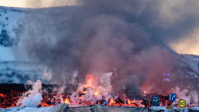
Residents of the evacuated seaside town of Grindavík in Iceland continue to hold their breath in anticipation of a possible volcanic eruption in the area after officials said magma has once again accumulated underground.
Residents of the evacuated seaside town of Grindavík in Iceland continue to hold their breath in anticipation of a possible volcanic eruption in the area after officials said magma has once again accumulated underground.

Weather Webcast with Meteorologist Eric Manges
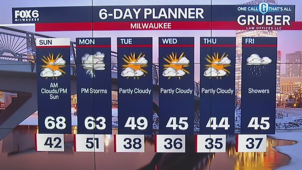
Warm into Monday but then storms Monday night
Warm into Monday but then storms Monday night
Weather webcast with Lisa Michaels
Isolated morning fog otherwise, mild as southeast winds bring in warm air pushing temps into the mid to upper 60s. Mostly sunny to party cloudy Sunday. Rain/storms return Monday afternoon into early Tuesday morning. Watching for the potential of an isolated strong storm. Another chance for rain on Friday as temperature stay in the mid-40s.
Isolated morning fog otherwise, mild as southeast winds bring in warm air pushing temps into the mid to upper 60s. Mostly sunny to party cloudy Sunday. Rain/storms return Monday afternoon into early Tuesday morning. Watching for the potential of an isolated strong storm. Another chance for rain on Friday as temperature stay in the mid-40s.

Weather Webcast with Meteorologist Eric Manges
Warm and breezy one Sunday then storm chances Monday
Warm and breezy one Sunday then storm chances Monday

Weather Webcast with Meteorologist Eric Manges
Big warm-up Sunday then some humble pie next week
Big warm-up Sunday then some humble pie next week
Weather webcast with Lisa Michaels
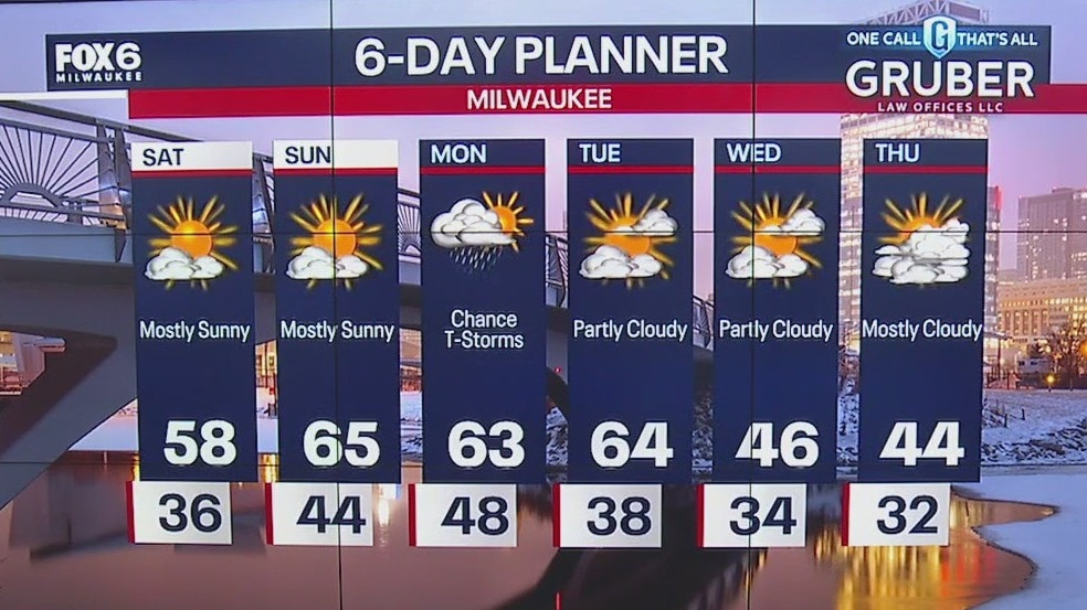
Mostly sunny to sunny skies on Saturday with highs reaching the upper 50s. Southeast wind makes it a little cooler near the lake. Sunday high temps remain in the mid-60s with breezy winds gusting near 30mph. Rain and possible storms return on Monday. Calm days mid-week with cooler temps back in the 40s.
Mostly sunny to sunny skies on Saturday with highs reaching the upper 50s. Southeast wind makes it a little cooler near the lake. Sunday high temps remain in the mid-60s with breezy winds gusting near 30mph. Rain and possible storms return on Monday. Calm days mid-week with cooler temps back in the 40s.
Weather Webcast with Meteorologist Eric Manges
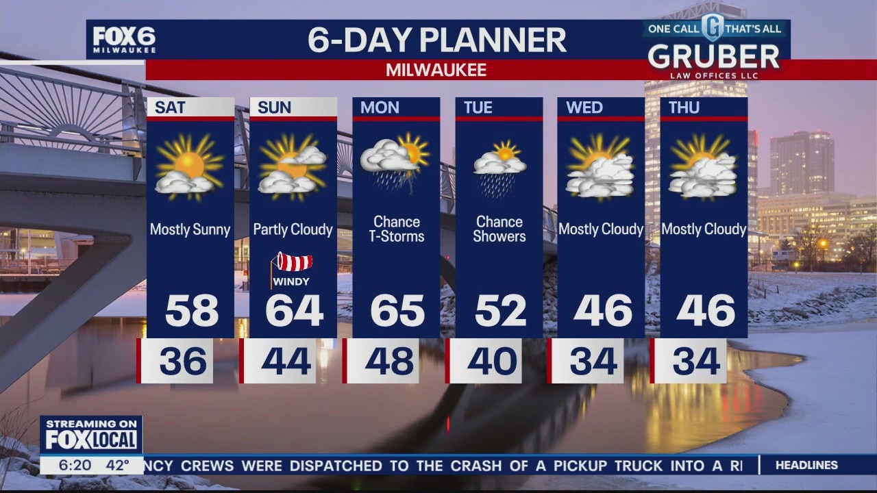
Warm up into the weekend but windy by Sunday
Warm up into the weekend but windy by Sunday