

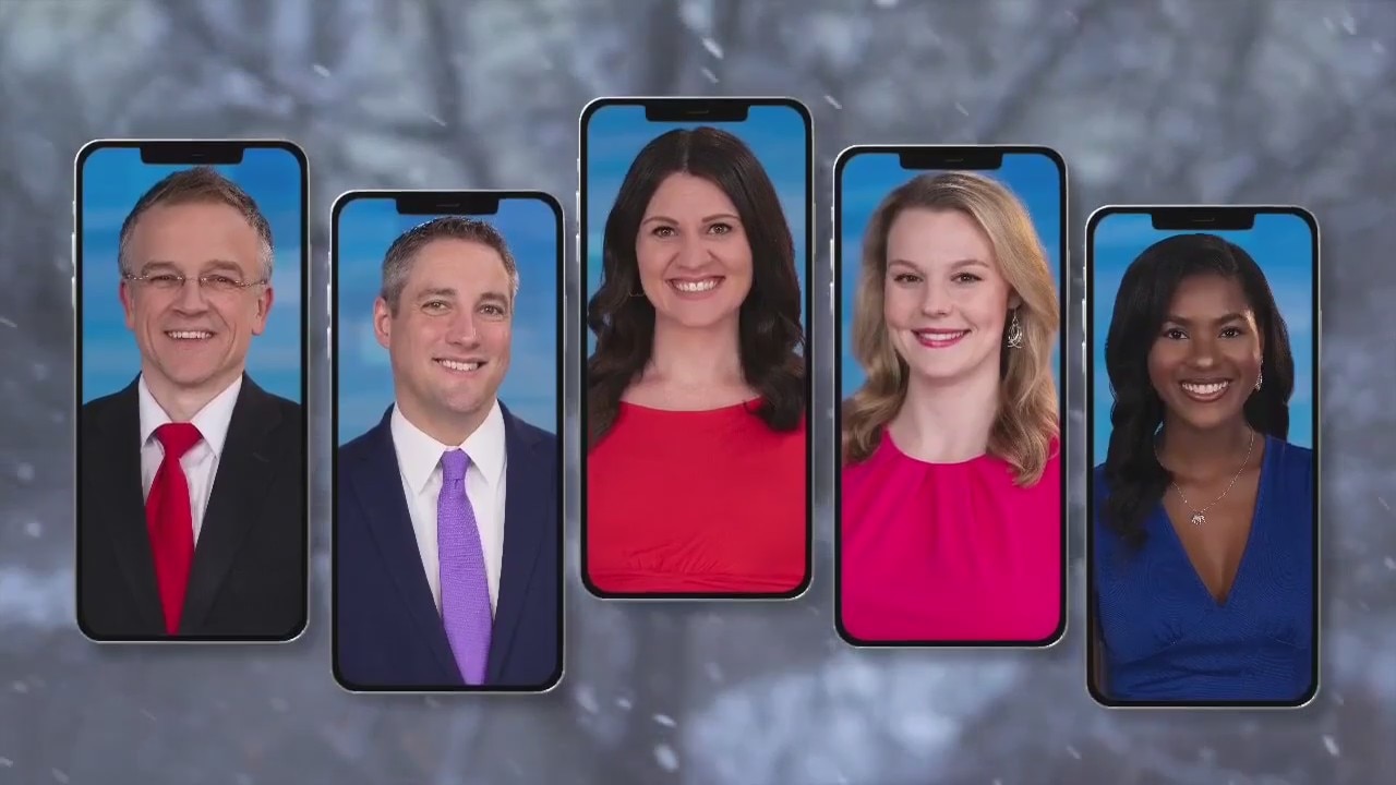
Wisconsin Weather Experts (Jan. 15)
The FOX6 Weather Experts bring you the day's weather update and offer meteorological updates.
The FOX6 Weather Experts bring you the day's weather update and offer meteorological updates.

Weather webcast with Stephanie Barichello
Sunny and warmer today with highs in the 20s, then a warm from brings light snow later this evening. Up to 1" possible, although most will stay below that.
Sunny and warmer today with highs in the 20s, then a warm from brings light snow later this evening. Up to 1" possible, although most will stay below that.
Weather webcast with Rob Haswell
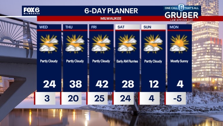
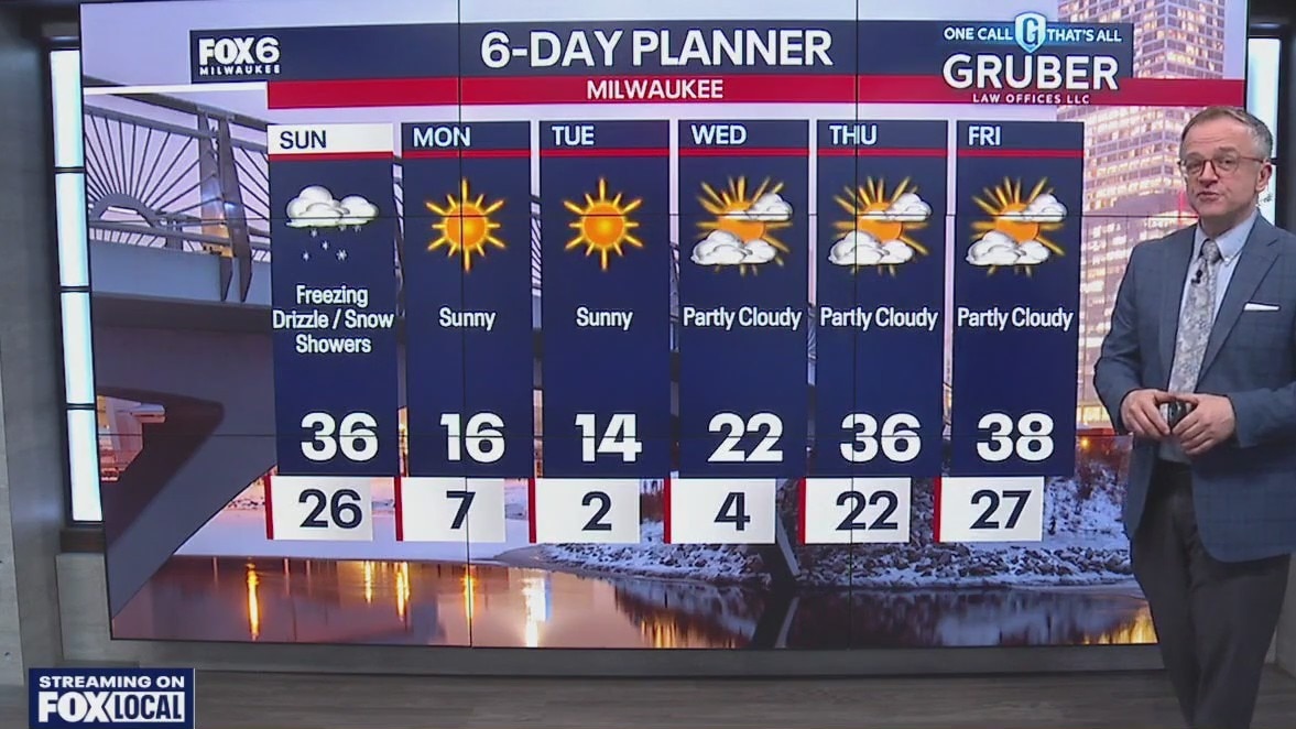
A clear and cold start to our Wednesday but we do some warming and get well above average for Thursday and Friday! After a single digit start we should see highs in the low to mid 20s followed by 30s and even 40s to wrap up the week. Clouds increase steadily and we could see some very light snow Wednesday night into Thursday morning with only a few tenths of an inch expected. Much colder air returns by Sunday into Monday.
A clear and cold start to our Wednesday but we do some warming and get well above average for Thursday and Friday! After a single digit start we should see highs in the low to mid 20s followed by 30s and even 40s to wrap up the week. Clouds increase steadily and we could see some very light snow Wednesday night into Thursday morning with only a few tenths of an inch expected. Much colder air returns by Sunday into Monday.
Weather webcast with Lisa Michaels
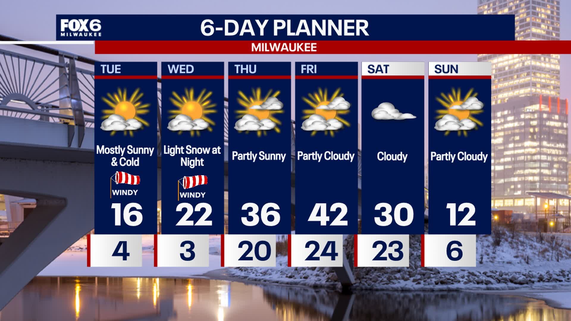
Mostly clear Tuesday night with low temperatures dropping into the single digits. Wind chills can range 0 to -5. As an area of high pressure moves on Wednesday, wind will begin to shift out of the south beginning a warming trend for the rest of the work week. Highs return to the 30s on Thrsuday and low 40s on Friday before another rush of very cold air moves in by next week. Next chance of a few light snow showers is Wednesday night. A dusting to a few tenths of an inch possible.
Mostly clear Tuesday night with low temperatures dropping into the single digits. Wind chills can range 0 to -5. As an area of high pressure moves on Wednesday, wind will begin to shift out of the south beginning a warming trend for the rest of the work week. Highs return to the 30s on Thrsuday and low 40s on Friday before another rush of very cold air moves in by next week. Next chance of a few light snow showers is Wednesday night. A dusting to a few tenths of an inch possible.
Weather Webcast with Stephanie Barichello
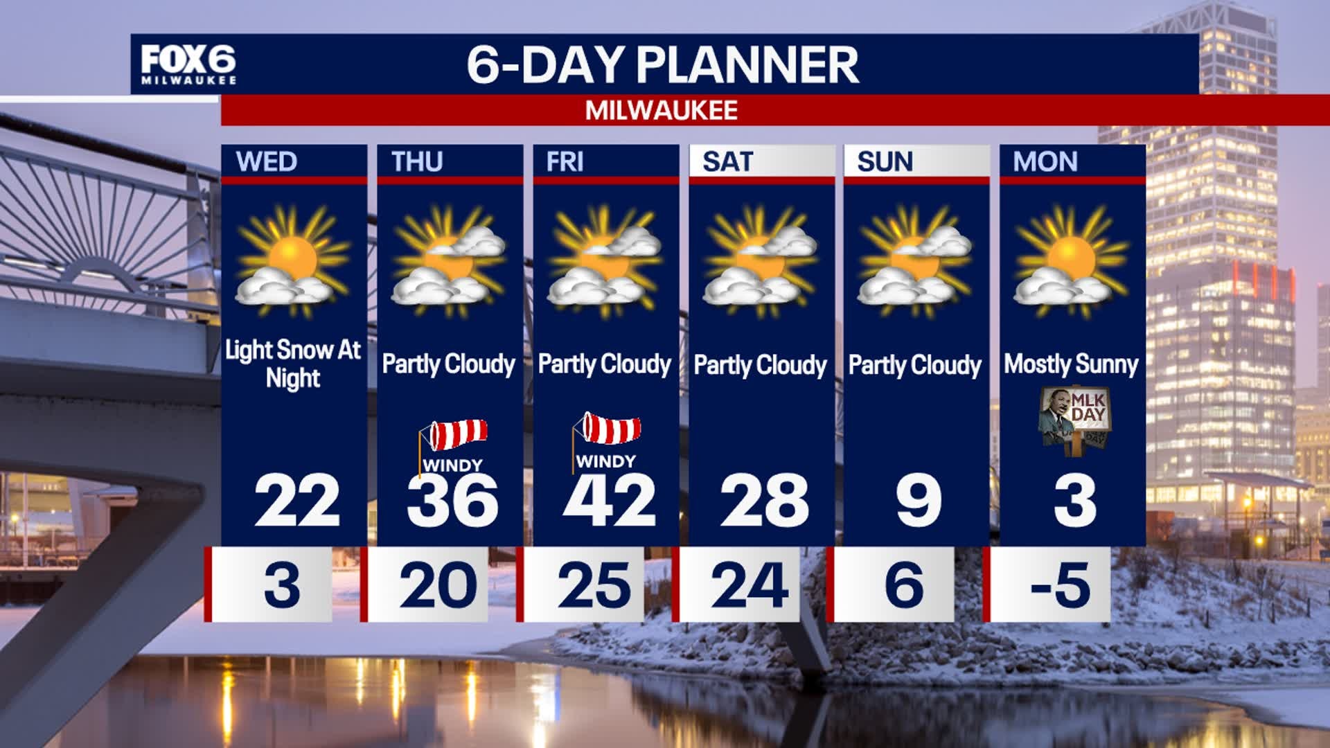
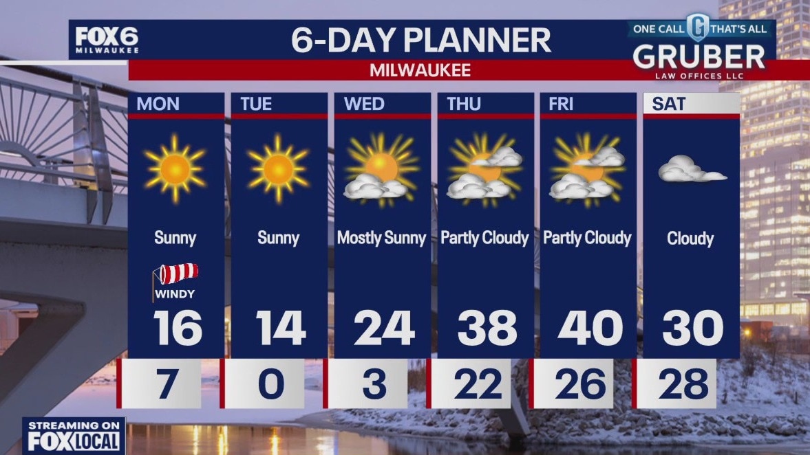
Sunny, windy and cold again today, then wind chills will once again drop into the teens below 0 overnight. A southwest wind returns Wednesday with highs in the 20s, then a chance for light snow or flurries at night. Even warmer to end the week but cold air moves back in Sunday.
Sunny, windy and cold again today, then wind chills will once again drop into the teens below 0 overnight. A southwest wind returns Wednesday with highs in the 20s, then a chance for light snow or flurries at night. Even warmer to end the week but cold air moves back in Sunday.

Weather webcast with Holly Baker
Temperatures will be cold again today with sunny skies. We start the morning with light snow/flurries, then sunny. A cold weather advisory will be in effect until 9AM. Wind chills could be as low as -15. A chance for light snow flurries late on Wednesday into Thursday morning. Temperatures will gradually warm to the 40's by Friday. Cold air returns Sunday, but still no major storm systems in sight.
Temperatures will be cold again today with sunny skies. We start the morning with light snow/flurries, then sunny. A cold weather advisory will be in effect until 9AM. Wind chills could be as low as -15. A chance for light snow flurries late on Wednesday into Thursday morning. Temperatures will gradually warm to the 40's by Friday. Cold air returns Sunday, but still no major storm systems in sight.


Wisconsin winter weather; staying safe in the cold
With the bitter cold comes safety concerns of frostbite and hypothermia. That's why doctors recommend being prepared for anything.
With the bitter cold comes safety concerns of frostbite and hypothermia. That's why doctors recommend being prepared for anything.

Weather webcast with Lisa Michaels
Mostly clear Monday night with temperatures dropping into the negative single digits inland to low single digits near the lake. A cold weather advisory has been issued for inland areas from 3AM to 9AM Tuesday. Wind chills below -20F are likely. The cold continues Tuesday and Wednesday with morning wind chills -10 to -20 below zero. Afternoon wind chills remain from -5 to 5. Temperatures begin to warm by the end of the week back in the low 40s by Friday. However, another big drop comes in time for the weekend.
Mostly clear Monday night with temperatures dropping into the negative single digits inland to low single digits near the lake. A cold weather advisory has been issued for inland areas from 3AM to 9AM Tuesday. Wind chills below -20F are likely. The cold continues Tuesday and Wednesday with morning wind chills -10 to -20 below zero. Afternoon wind chills remain from -5 to 5. Temperatures begin to warm by the end of the week back in the low 40s by Friday. However, another big drop comes in time for the weekend.


Waukesha emergency overflow shelter to reopen; bitter cold settles in
The Waukesha winter overflow shelter is set to reopen after a major setback.
The Waukesha winter overflow shelter is set to reopen after a major setback.

Milwaukee Water Works: Tips to prevent frozen, burst water pipes
Bitter cold air has descended on southeast Wisconsin and that often leads to pipes to freeze or burst. But there are steps you can take to prevent such damage in your home.
Bitter cold air has descended on southeast Wisconsin and that often leads to pipes to freeze or burst. But there are steps you can take to prevent such damage in your home.


Arctic air, potentially dangerous wind chills slated for Wisconsin
Bitter cold arctic air returns to Wisconsin. The National Weather Service may issue a Cold Weather Advisory for potentially dangerous wind chills Monday night and Tuesday morning.
Bitter cold arctic air returns to Wisconsin. The National Weather Service may issue a Cold Weather Advisory for potentially dangerous wind chills Monday night and Tuesday morning.
Weather webcast with Rob Haswell
A very cold air mass is moving over our region for today and tomorrow. Highs will be in the low teens and feel much colder with a strong W-NW wind. Wind chill readings will be in the -10 to -20 range for some areas.
A very cold air mass is moving over our region for today and tomorrow. Highs will be in the low teens and feel much colder with a strong W-NW wind. Wind chill readings will be in the -10 to -20 range for some areas.

Weather webcast with Lisa Michaels
Patchy freezing drizzle and flurries early Sunday night. Surfaces may refreeze into Monday morning. Lows in the single digits with wind chills 0 to -10. Sunny skies return at the start of the week but arctic air will make it very cold. Highs in the teens Monday and Tuesday with wind chills 0 to -10. Temperatures warm back into the upper 30s to low 40s by the end of the week. Another surge of very cold air returns by next weekend.
Patchy freezing drizzle and flurries early Sunday night. Surfaces may refreeze into Monday morning. Lows in the single digits with wind chills 0 to -10. Sunny skies return at the start of the week but arctic air will make it very cold. Highs in the teens Monday and Tuesday with wind chills 0 to -10. Temperatures warm back into the upper 30s to low 40s by the end of the week. Another surge of very cold air returns by next weekend.
Weather webcast with Rob Haswell
Patchy freezing drizzle and a few flurries expected this morning with a chance for a few flurries again this afternoon. Another milder day today with highs in the low to mid 30s which is well above the climate averages for the period.
Patchy freezing drizzle and a few flurries expected this morning with a chance for a few flurries again this afternoon. Another milder day today with highs in the low to mid 30s which is well above the climate averages for the period.

Weather Webcast with Chief Meteorologist Tom Wachs
Light snow overnight largely ending by 5am. Scattered light snow showers and a light mix possible off-and-on during the day Sunday. Blustery with a high in the mid-30s. A few tenths of an inch (dusting ) of snow possible from this system.
Light snow overnight largely ending by 5am. Scattered light snow showers and a light mix possible off-and-on during the day Sunday. Blustery with a high in the mid-30s. A few tenths of an inch (dusting ) of snow possible from this system.

Weather Webcast with Chief Meteorologist Tom Wachs
Light snow will move in overnight. The steadiest snow will be overnight with light snow/mix on Sunday morning into the afternoon. Around 1" of snow is expected, lower south and slightly higher north of Milwaukee.
Light snow will move in overnight. The steadiest snow will be overnight with light snow/mix on Sunday morning into the afternoon. Around 1" of snow is expected, lower south and slightly higher north of Milwaukee.

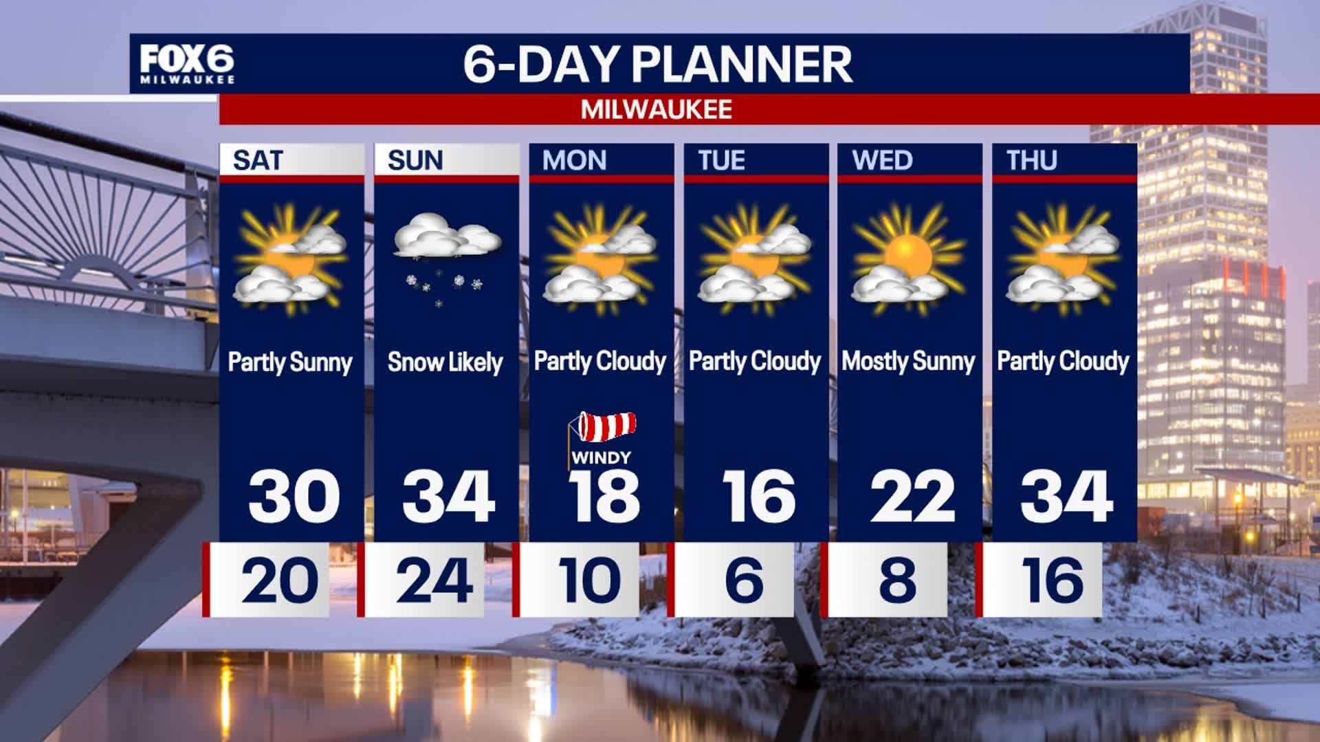
Weather webcast with Lisa Michaels
Clouds early Saturday then gradually decreasing for the day. Increasing clouds again late this afternoon into tonight. Highs in the upper 20s to low 30s. Clouds increase tonight with the approach of another low-pressure system. This will bring snow after 10PM through midday Sunday. Snow will begin to accumulate after midnight. 1-2" of snowfall accumulation will be possible with isolated areas inland that can be closer to 3". Colder air returns early next week with highs back in the teens and lows in the single digits. Wind chills back below zero Monday into Tuesday.
Clouds early Saturday then gradually decreasing for the day. Increasing clouds again late this afternoon into tonight. Highs in the upper 20s to low 30s. Clouds increase tonight with the approach of another low-pressure system. This will bring snow after 10PM through midday Sunday. Snow will begin to accumulate after midnight. 1-2" of snowfall accumulation will be possible with isolated areas inland that can be closer to 3". Colder air returns early next week with highs back in the teens and lows in the single digits. Wind chills back below zero Monday into Tuesday.
Weather Webcast with Stephanie Barichello
Some sun to start Saturday then snow returns Saturday night into Sunday morning. 1-3" will be possible, with highest totals across northern counties. Cold early next week, but a quiet week ahead.
Some sun to start Saturday then snow returns Saturday night into Sunday morning. 1-3" will be possible, with highest totals across northern counties. Cold early next week, but a quiet week ahead.


Fire weather watch vs. red flag warning: What is the difference?
We've seen reports about Los Angeles County being under "fire weather watch" and "red flag warning." What is the difference?
We've seen reports about Los Angeles County being under "fire weather watch" and "red flag warning." What is the difference?

Weather webcast with Lisa Michaels
A weak cold front moving through today could generate a few snow showers or some before we clear out this afternoon. A few flurries possible tonight. Highs will once again be near average. Our next chance for snow comes Saturday night into Sunday with a couple of inches possible. Colder air returns early next week with highs back in the teens and lows in the single digits.
A weak cold front moving through today could generate a few snow showers or some before we clear out this afternoon. A few flurries possible tonight. Highs will once again be near average. Our next chance for snow comes Saturday night into Sunday with a couple of inches possible. Colder air returns early next week with highs back in the teens and lows in the single digits.