

Weather webcast with Rob Haswell
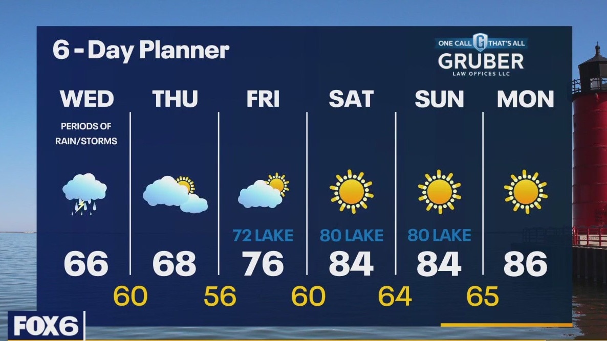
Another wet day with rounds of rain and a chance for thunderstorms. We will be cooler today with highs in the low to mid 60s. A strong SE-E wind will cause high waves and strong currents resulting in a Beach Hazards Statement until 10pm. We dry up after a few early showers Thursday and start warming up Friday with highs returning to the 80s by the weekend. We stay much warmer than average through the middle of next week.
Another wet day with rounds of rain and a chance for thunderstorms. We will be cooler today with highs in the low to mid 60s. A strong SE-E wind will cause high waves and strong currents resulting in a Beach Hazards Statement until 10pm. We dry up after a few early showers Thursday and start warming up Friday with highs returning to the 80s by the weekend. We stay much warmer than average through the middle of next week.
Weather Webcast with Tom Wachs
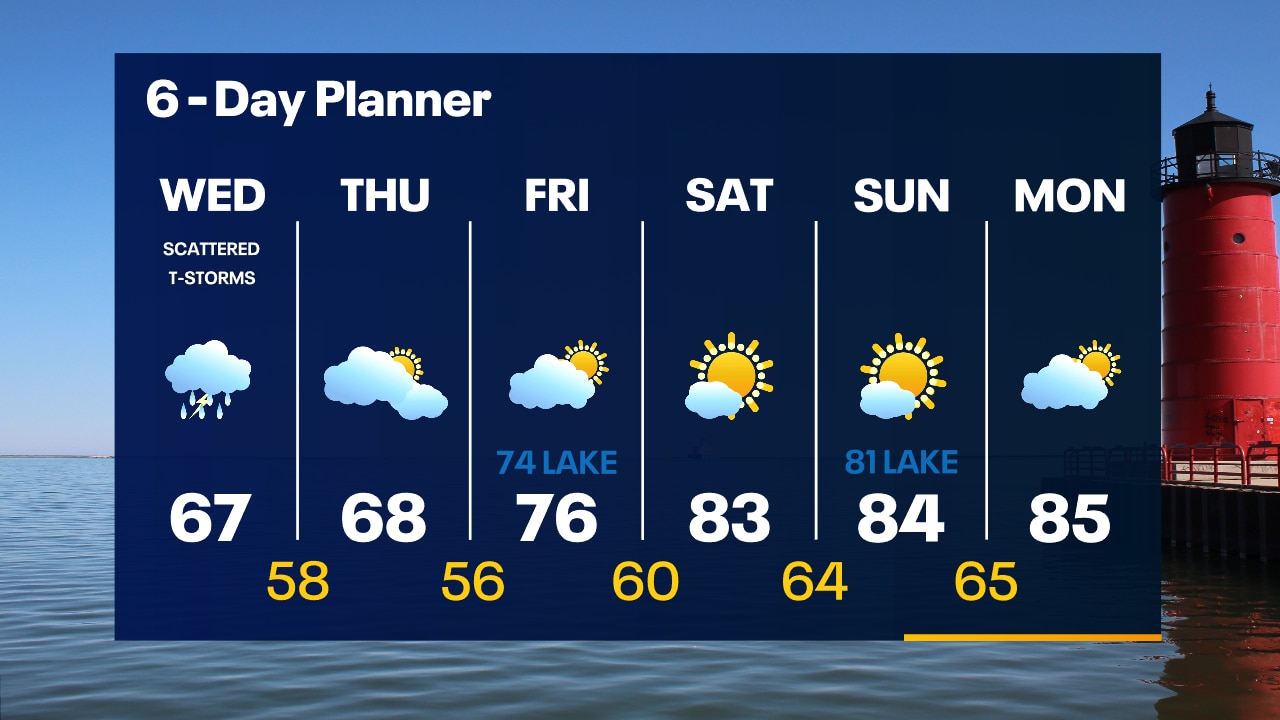
Scattered showers and a few rumbles of thunder overnight. Temperatures in the 60s. Another day with scattered showers and t-storms on Wednesday with highs in the 60s.
Scattered showers and a few rumbles of thunder overnight. Temperatures in the 60s. Another day with scattered showers and t-storms on Wednesday with highs in the 60s.

Tropical Storm Philippe continues to struggle but Invest 91L expected to develop soon in Atlantic
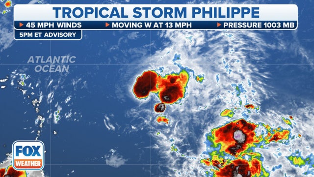
The National Hurricane Center has highlighted a disturbance several hundred miles west-southwest of the Cabo Verde Islands in the central tropical Atlantic, noting that a tropical depression is likely to form in the next couple of days.
The National Hurricane Center has highlighted a disturbance several hundred miles west-southwest of the Cabo Verde Islands in the central tropical Atlantic, noting that a tropical depression is likely to form in the next couple of days.
Weather Webcast with Tom Wachs
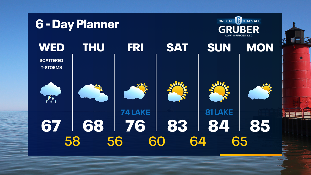
Scattered showers and t-storms will redevelop over Lake Michigan later tonight and move northwest into our area. Scattered showers and t-storms continue in the forecast on Wednesday.
Scattered showers and t-storms will redevelop over Lake Michigan later tonight and move northwest into our area. Scattered showers and t-storms continue in the forecast on Wednesday.
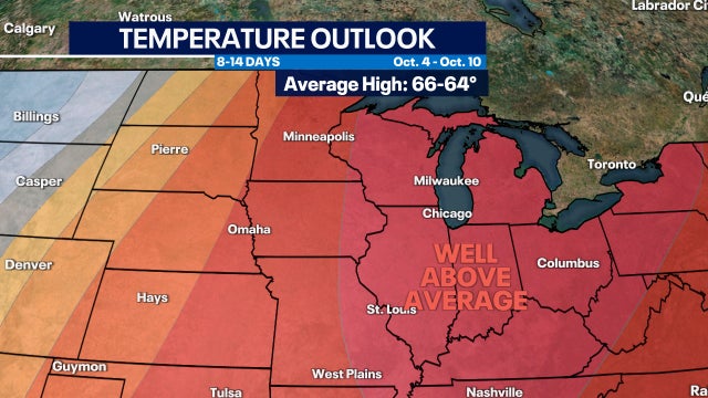

Late summer warmth favored into mid-October; will fall ever arrive?
Warmer than average temperatures are favored for the Great Lakes into mid-October but does this mean Fall will never arrive? Long term it's inevitable.
Warmer than average temperatures are favored for the Great Lakes into mid-October but does this mean Fall will never arrive? Long term it's inevitable.
Weather Webcast with Stephanie Barichello
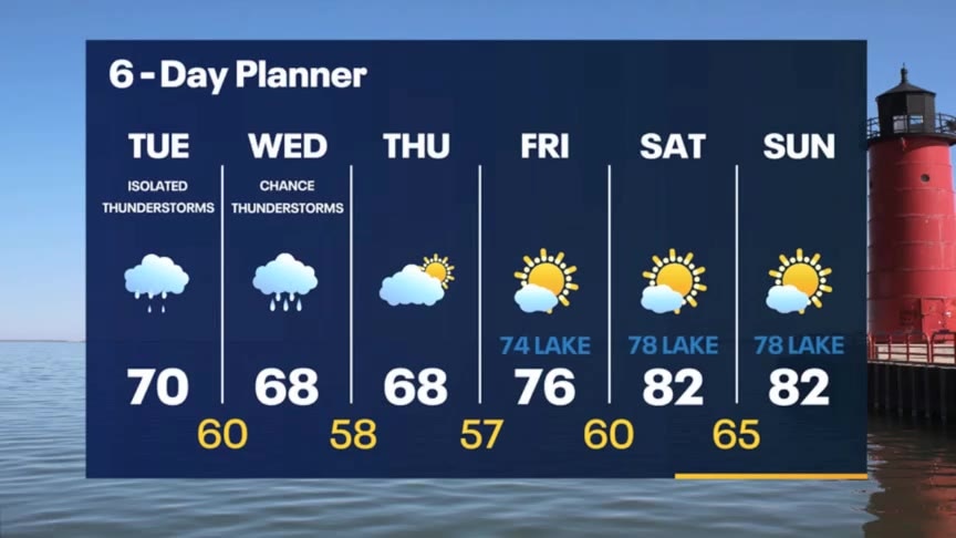
Scattered showers expected this afternoon and evening with temperatures around 70. Another soggy and dreary day Wednesday then improving conditions Thursday. Warming by the weekend with 80s inland.
Scattered showers expected this afternoon and evening with temperatures around 70. Another soggy and dreary day Wednesday then improving conditions Thursday. Warming by the weekend with 80s inland.
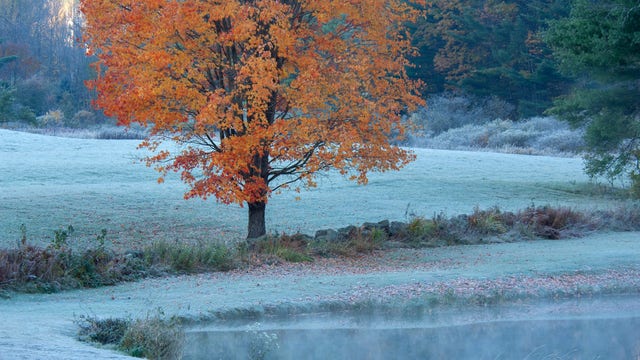

Here’s when to expect the first freeze of the season
Average weather conditions over many years provide guidance on when to expect the season’s first 32-degree temperature. Here's what's predicted for your area.
Average weather conditions over many years provide guidance on when to expect the season’s first 32-degree temperature. Here's what's predicted for your area.
Weather webcast with Rob Haswell
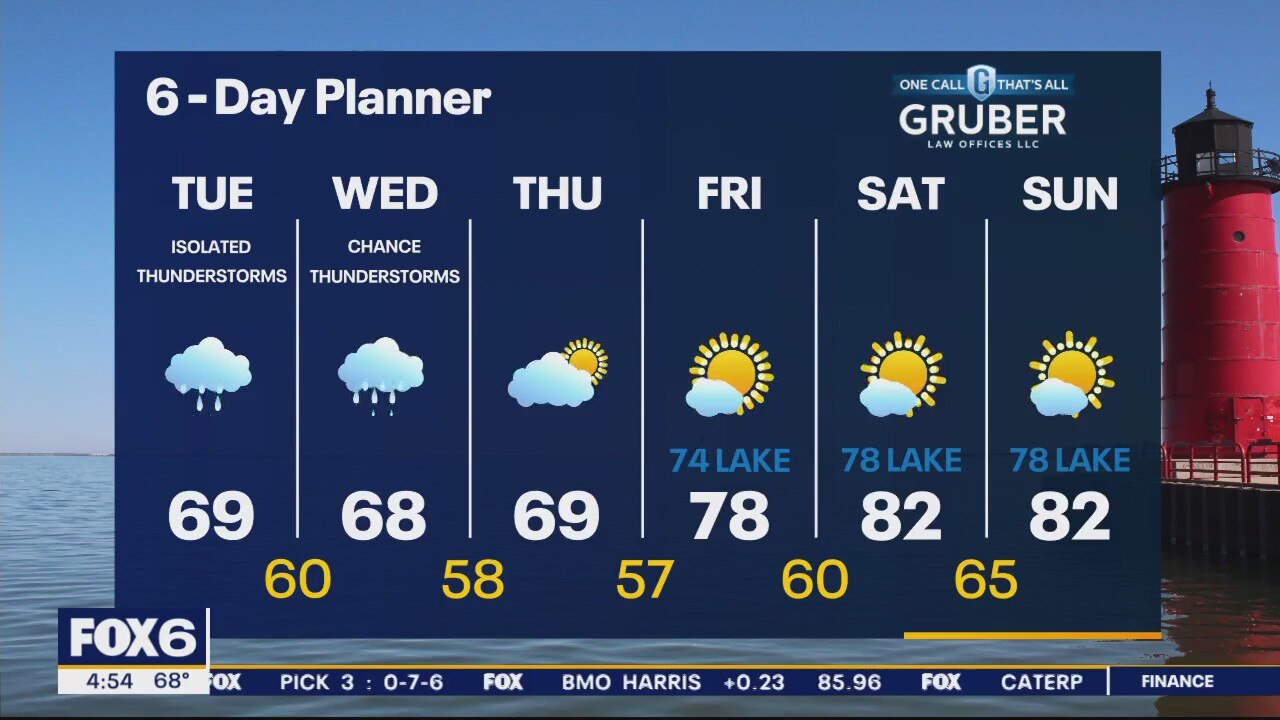
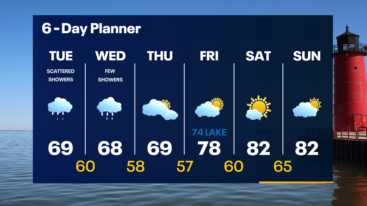
Another day with this slow-moving low-pressure system. Periods of rain and thunderstorms are likely. Highs today will be in the upper 60s to near 70. The breeze will pick up out of the SE and will generate high waves and strong currents. A Beach Hazards Statement goes into effect this evening through Wednesday evening. More showers on Wednesday then drying up and warming up by the weekend!
Another day with this slow-moving low-pressure system. Periods of rain and thunderstorms are likely. Highs today will be in the upper 60s to near 70. The breeze will pick up out of the SE and will generate high waves and strong currents. A Beach Hazards Statement goes into effect this evening through Wednesday evening. More showers on Wednesday then drying up and warming up by the weekend!
Weather Webcast with Tom Wachs
Soggy conditions Tuesday morning with spotty showers Tuesday afternoon. Highs in the upper 60s. A few more rain showers are possible Wednesday before the sun returns late in the week.
Soggy conditions Tuesday morning with spotty showers Tuesday afternoon. Highs in the upper 60s. A few more rain showers are possible Wednesday before the sun returns late in the week.
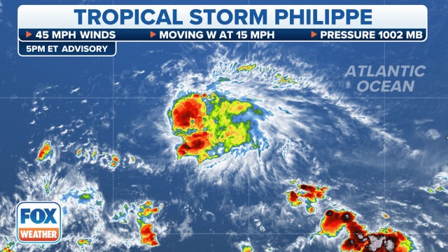

Tropical Storm Philippe continues west while Invest 91L in central Atlantic has high chance of development
The National Hurricane Center has highlighted a disturbance several hundred miles west-southwest of the Cabo Verde Islands in the eastern tropical Atlantic, currently giving it a high chance of development in the next 2-3 days.
The National Hurricane Center has highlighted a disturbance several hundred miles west-southwest of the Cabo Verde Islands in the eastern tropical Atlantic, currently giving it a high chance of development in the next 2-3 days.
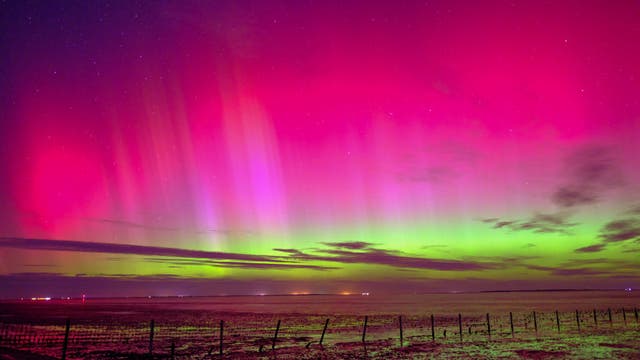

Northern Lights activity to increase, include auroras further south due to escalating Sun activity
Skygazers in the northern U.S. will want to stay tuned for more aurora light forecasts in the coming years as peak solar activity is expected in 2025 during the Solar Cycle 25.
Skygazers in the northern U.S. will want to stay tuned for more aurora light forecasts in the coming years as peak solar activity is expected in 2025 during the Solar Cycle 25.

Weather Webcast with Tom Wachs
Mostly cloudy tonight with a few off-and-on rain showers later this evening and overnight. This trend continues on Tuesday with highs in the upper 60s.
Mostly cloudy tonight with a few off-and-on rain showers later this evening and overnight. This trend continues on Tuesday with highs in the upper 60s.

Weather webcast with Lisa Michaels
An area of low pressure slowly moves from the NW to the SE over our area today and tomorrow bringing periods of rain and a few chances for thunderstorms. Highs today will be in the upper 60s to low 70s and cool to the mid to upper 60s Tuesday and Wednesday. We dry up by Thursday and temperatures start to warm up with highs returning to the upper 70s to near 80 by the weekend. Above average temperatures remain in place through early October.
An area of low pressure slowly moves from the NW to the SE over our area today and tomorrow bringing periods of rain and a few chances for thunderstorms. Highs today will be in the upper 60s to low 70s and cool to the mid to upper 60s Tuesday and Wednesday. We dry up by Thursday and temperatures start to warm up with highs returning to the upper 70s to near 80 by the weekend. Above average temperatures remain in place through early October.


After summer's extreme weather, more people view climate change as a culprit, poll finds
A new poll found that most Americans believe they've personally felt the impact of climate change because of recent extreme weather, including a summer that brought dangerous heat for much of the country.
A new poll found that most Americans believe they've personally felt the impact of climate change because of recent extreme weather, including a summer that brought dangerous heat for much of the country.

Weather webcast with Rob Haswell
An area of low pressure slowly moves from the NW to the SE over our area today and tomorrow bringing periods of rain and a few chances for thunderstorms. Highs today will be in the upper 60s to low 70s and cool to the mid to upper 60s Tuesday and Wednesday. We dry up by Thursday and temperatures start to warm up with highs returning to the upper 70s to near 80 by the weekend. Above average temperatures remain in place through early October.
An area of low pressure slowly moves from the NW to the SE over our area today and tomorrow bringing periods of rain and a few chances for thunderstorms. Highs today will be in the upper 60s to low 70s and cool to the mid to upper 60s Tuesday and Wednesday. We dry up by Thursday and temperatures start to warm up with highs returning to the upper 70s to near 80 by the weekend. Above average temperatures remain in place through early October.

Weather Webcast with Tom Wachs
A few rain showers are possible overnight with temperatures in the 60s. Spotty rain showers continue in the forecast Monday, otherwise mostly cloudy with a high around 70.
A few rain showers are possible overnight with temperatures in the 60s. Spotty rain showers continue in the forecast Monday, otherwise mostly cloudy with a high around 70.
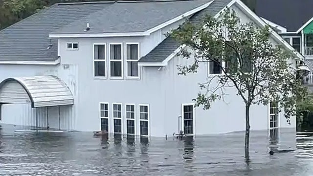

Ophelia’s remnants continue to batter US coast with large waves, strong winds from mid-Atlantic to Northeast
Lingering effects from Ophelia continued in the mid-Atlantic on Sunday, as the brunt of the storm slammed into the Northeast and New England.
Lingering effects from Ophelia continued in the mid-Atlantic on Sunday, as the brunt of the storm slammed into the Northeast and New England.

Weather Webcast with Tom Wachs
Mostly cloudy tonight with a few rain showers possible overnight. Temperatures dropping through the 60s. Mostly cloudy on Monday with a slight chance for rain showers. High around 70.
Mostly cloudy tonight with a few rain showers possible overnight. Temperatures dropping through the 60s. Mostly cloudy on Monday with a slight chance for rain showers. High around 70.

Weather Webcast with Meteorologist Lisa Michaels
Partly cloudy skies Sunday with highs in the low 70s. A few showers possible this afternoon especially in areas closer to I-90. Due to a cut-off low, additional rain chances are possible Monday through early Wednesday next week.
Partly cloudy skies Sunday with highs in the low 70s. A few showers possible this afternoon especially in areas closer to I-90. Due to a cut-off low, additional rain chances are possible Monday through early Wednesday next week.

Weather Webcast with Meteorologist Eric Manges
Cloudy to end the weekend and start next week but a couple rain chances
Cloudy to end the weekend and start next week but a couple rain chances